Six BGS datasets for assessing shrink–swell subsidence hazards
Shrink–swell subsidence is one of the most significant geological hazards affecting the UK. BGS has six datasets to help assess the problem.
17/02/2023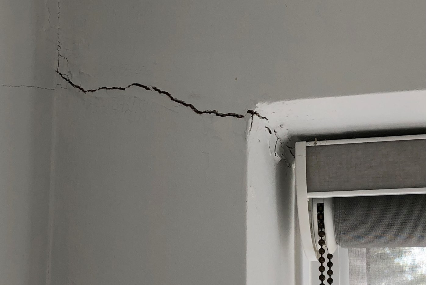

Many towns, cities and major infrastructure corridors in the UK are founded on clay-rich soils, especially in the south-east of the UK including much of London. Differences in the properties of underlying geology and regional climate across the UK result in localised changes in susceptibility due to shrink–swell subsidence (Jones and Jefferson, 2012; Jones et al., 2020). It is predicted that climate change will also have a significant effect on the magnitude and frequency of shrink–swell subsidence incidents.
Outlined here is the full range of BGS shrink–swell subsidence data products, which are designed to offer complementary assessments of susceptibility at a range of scales for a range of different uses and users. These include:
General users: Specialist users:- BGS GeoSure Insurance Product
- BGS Property Subsidence Assessment
- BGS GeoSure Extra Shrink–swell 3D
- BGS GeoSure Extra Shrink–swell Subsurface
The importance of BGS datasets
It is important to understand where shrink–swell hazard might be present to assess, adapt and mitigate for it. Natural ground instability may lead to financial loss if it is not correctly identified and infrastructure constructed accordingly.
This suite of data products from the UK’s premier geoscience institute can support the identification of this geohazard and the implementation of preventative measures, the cost of which may be very low compared to the cost of the repair following ground movement.
BGS GeoSure
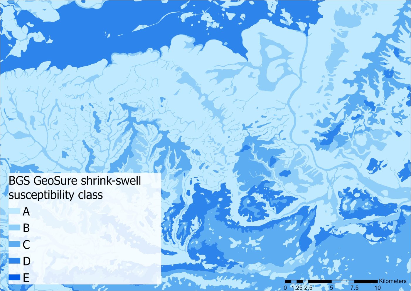
BGS GeoSure shrink–swell layer example. BGS © UKRI.
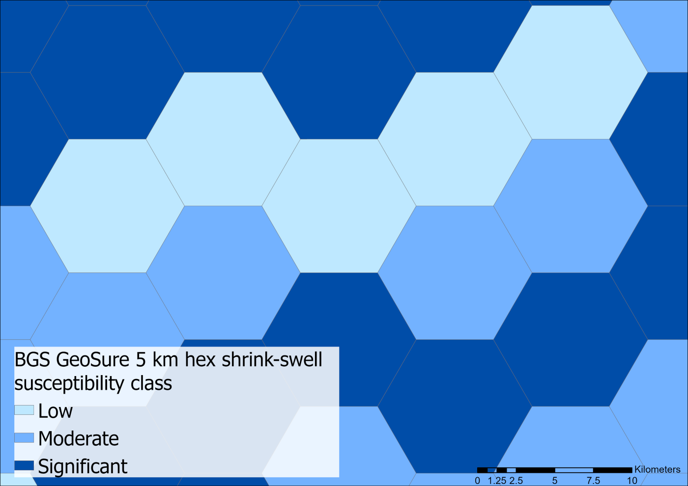
BGS GeoSure 5 km hex grid example. BGS © UKRI.
What is it?
BGS GeoSure comprises natural ground stability data and consists of six data layers, including shrink–swell. Each layer is a national hazard susceptibility map for the following ground instability hazards:
- collapsible deposits
- compressible ground
- landslides
- running sand
- shrink–swell subsidence
- soluble rocks
What information does it provide?
This dataset shows areas of susceptibility for each hazard on a scale of A to E (low to high susceptibility) along with a class description. A free, open-source version of the BGS GeoSure datasets is available as a 5 km hex grid, which provides a generalised, national to regional overview of hazard susceptibility.
Coverage
- Great Britain
Suitable uses
This dataset can be used to assess the potential presence of geohazards that might affect low-rise buildings, and for the identification and classification of those geohazards.
Users could include:
- architects and surveyors
- developers
- home owners
- insurers and loss adjusters
- local government and regional planners
- solicitors
BGS GeoClimate Shrink–swell
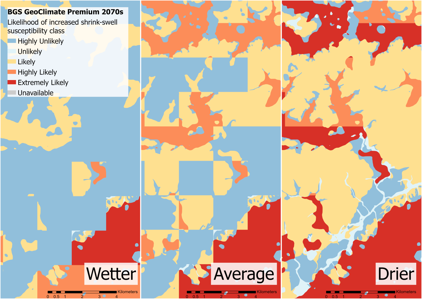
BGS GeoClimate Premium example for three different climate scenarios (wetter, average and drier) in the 2070s time period. BGS © UKRI.
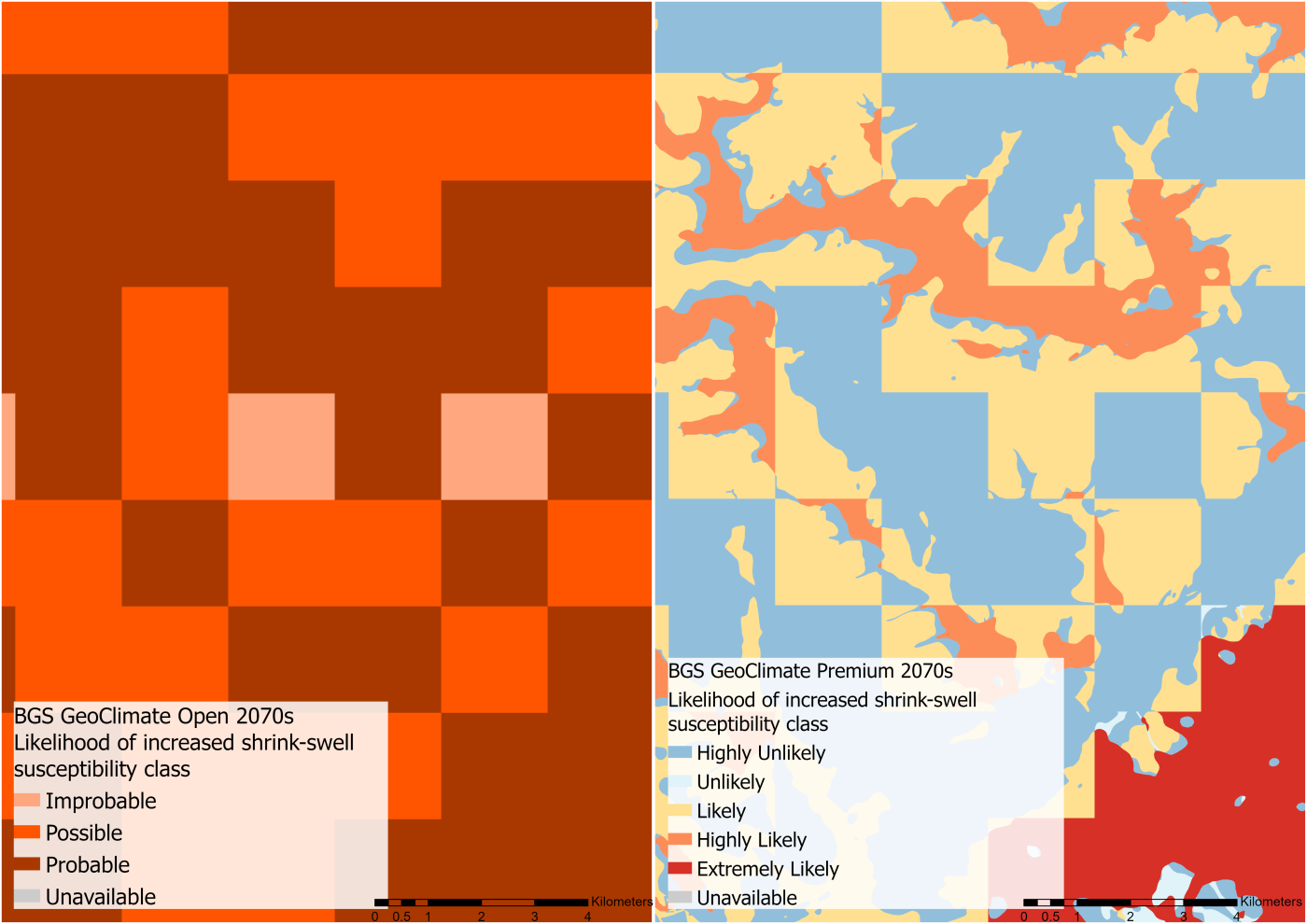
BGS GeoClimate Open (left) compared to BGS GeoClimate Premium (right). BGS © UKRI.
What is it?
BGS GeoClimate Shrink–swell comprises national datasets showing potential change in subsidence due to changes in climate for the next century.
How is it different to GeoSure?
GeoClimate provides added detail for the potential effects of climate change. This is demonstrated through a number of different climate scenario thresholds.
What information does it provide?
UKCP18 climate projections and groundwater models are combined with GeoSure Shrink–swell hazard maps to model future shrink–swell susceptibility for two time periods: 2030s (2025 to 2035) and 2070s (206 to 2075). GeoClimate provides a ‘hot spot’ map of susceptible areas, which can inform mitigation strategies, prioritise works and aid risk reduction.
An assessment of the likelihood to experience an increase in susceptibility is provided for three scenarios for each time period. These represent wetter, drier and average future climate conditions, and convey the variation and uncertainty within the scenario modelling. This allows the user to consider the best- and worst-case scenario according to their needs.
A difference map is also provided to allow for comparison, detailing the relative change in GeoClimate classification compared to a modelled baseline period.
An open version of GeoClimate is freely available and consists of the average scenario for future climate conditions for the two time periods, provided on a 2 km grid.
Coverage
- Great Britain
Suitable uses
GeoClimate is of use to a broad range of market sectors dealing with resilience to future climate change including:
- heritage
- infrastructure operators
- local authorities
- planning and development
- utilities
BGS GeoSure Insurance Product
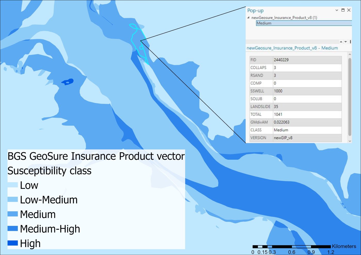
BGS GeoSure Insurance Product example. BGS © UKRI.
What is it?
The BGS GeoSure Insurance Product (GIP), designed specifically for use in the insurance sector, is an index-level assessment of the potential for a geological deposit to create financial insurance loss due to natural ground movement.
What information does it provide?
GIP incorporates the combined effects of the six BGS GeoSure hazards on (low-rise) buildings and links these to a postcode database. This database contains a normalised hazard rating for each of the six hazards (that is, each hazard has been balanced against each other). Full vector data is available for property assessment, whilst a combined unified hazard rating is available for each postcode in Great Britain.
Coverage
- Great Britain
Suitable uses
This dataset was developed for the insurance sector to quantify ground instability susceptibility in a way that is comparable between hazards and considers the potential effect on a building. It is also applicable to other financial sectors, such as banking or mortgage providers, for quantifying susceptibility of asset portfolios.
BGS Property Subsidence Assessment
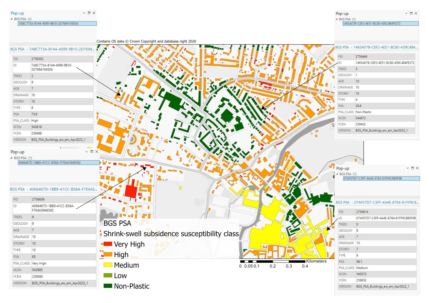
Property subsidence assessment example. BGS © UKRI.
What is it?
BGS Property Subsidence Assessment (PSA) offers property and postcode-level assessments of shrink–swell susceptibility, considering the potential influences of geological and building characteristics.
How is it different to GeoSure?
PSA focuses solely on the shrink–swell subsidence hazard, providing a higher resolution, specialised assessment. It considers key influencing factors (building characteristics; tree proximity) in its assessment. It is complemented by BGS GeoSure and the BGS GeoSure Insurance Product, which provide assessments of susceptibility for a much broader range of ground instability hazards.
What information does it provide?
This dataset uses a combination of geology, tree location and building characteristics to assess shrink–swell susceptibility. These factors are combined to calculate a subsidence hazard score at the building and postcode scales. A recent BGS blog outlines the features of this dataset in greater detail.
Coverage
- England and Wales
Suitable uses
PSA includes a risk element for the housing stock at postcode and building level, making it ideal for use in the property report and insurance sectors.
BGS GeoSure Extra Shrink–swell 3D
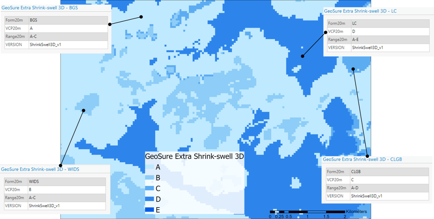
BGS GeoSure Extra Shrink–swell 3D example. BGS © UKRI.
What is it?
The BGS GeoSure Extra Shrink–swell 3D dataset identifies the shrink–swell potential for subsurface or concealed deposits in the London area.
How is it different to BGS GeoSure?
BGS GeoSure provides information on shrink–swell hazard susceptibility in the shallow subsurface (upper 5 m). The 3D model data provides additional information at greater depth, to 20 m.
What information does it provide?
Plasticity ranges in line with GeoSure A to E ratings are applied to data extracted from the London 3D geological model and provided in GIS format. The product identifies areas of potential shrink–swell hazard, in 3D space, down to 20 m in the London Lithoframe area of Great Britain. Shrink–swell/plasticity is provided on a 50 m grid at various depths below surface (1, 2, 3, 4, 5, 10, 15 and 20 m) but can be varied depending on need.
Coverage
- London and the Thames Valley
Suitable uses
This product is designed for the ground engineering markets and infrastructure sectors. Operators for infrastructure such as deep cuttings, tunneling, deep foundations for major construction projects, etc. will find this detailed information useful at a planning stage.
BGS GeoSure Extra Shrink–swell Subsurface
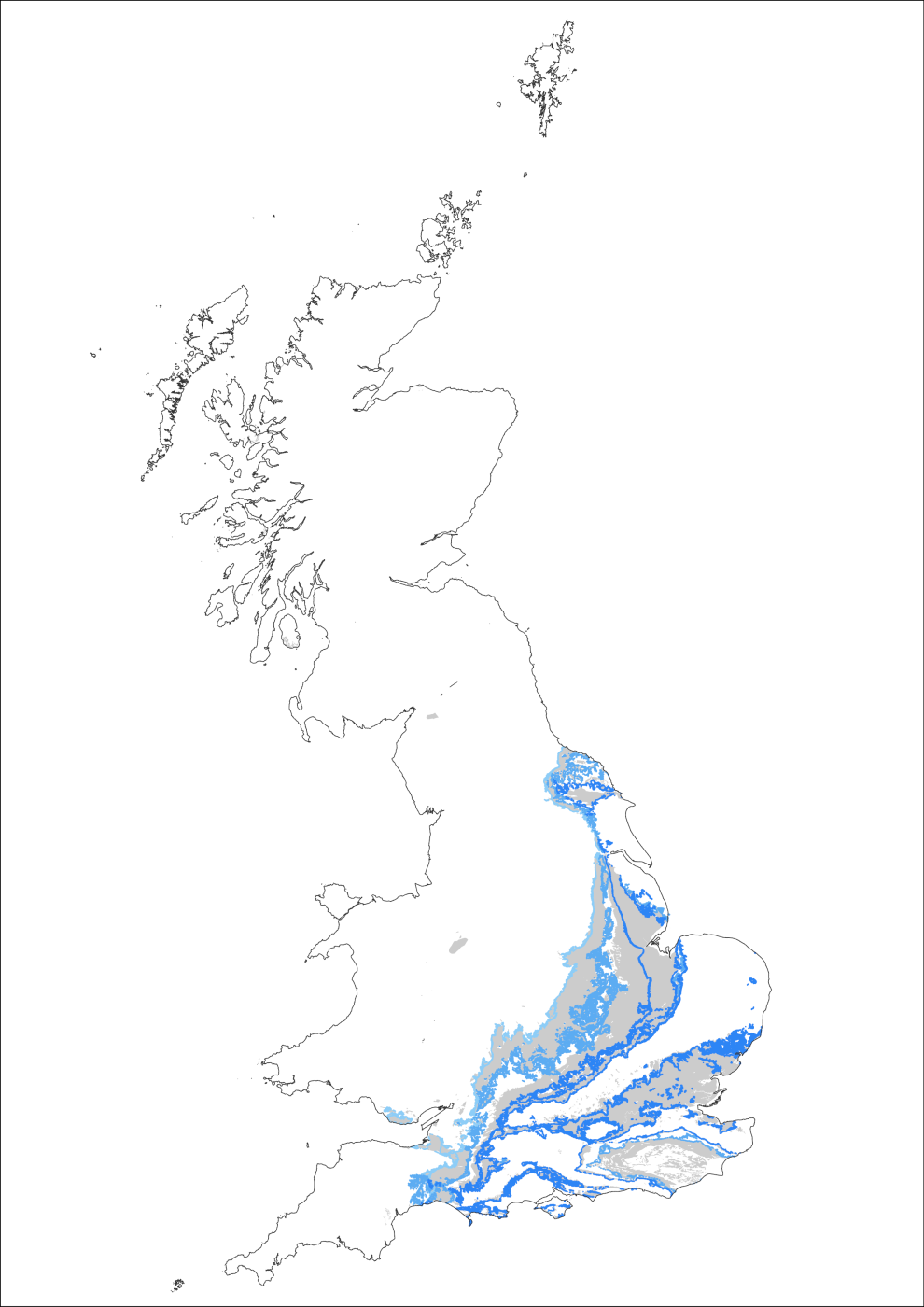
BGS GeoSure Shrink–swell Subsurface coverage. BGS © UKRI.
What is it?
BGS GeoSure Extra Shrink–swell subsurface provides information on shrink–swell potential for shallow subcrop (up to 10 m) clays.
How is it different to BGS GeoSure?
BGS GeoSure provides shrink–swell hazard susceptibility for the upper 5 m of geology only. BGS GeoSure Shrink–swell Subsurface provides a deeper assessment of susceptibility, found beneath other deposits, at a much coarser resolution.
What information does it provide?
This product extends the BGS GeoSure Shrink–swell values into the shallow subsurface, providing information for the eight major clay formations across Great Britain that are underneath another solid formation and therefore hidden from the surface. These are analysed up to 10 m depth for deeper foundation structures.
Coverage
- Partial Great Britain coverage (limited to the main clay formations)
Suitable uses
BGS GeoSure Shrink–swell Subsurface is suitable for screening and desk-based assessments of:
- construction of deep foundations, basements and other such large infrastructure
- infrastructure networks (road and rail)
- utility development
- scoping for civil engineering projects
Contact
If you have any questions or would like to discuss which of these datasets is best suited to your needs, please email the digital data team (digitaldata@bgs.ac.uk).
References
Jones, L D, and Jefferson, I. 2012. Expansive soils. Chapter 33 in ICE Manual of Geotechnical Engineering: Volume I. Burland, J, Chapman, T, Skinner, H, and Brown, M (editors). (London, UK: Institute of Civil Engineers.)
Jones, L, Banks, V, and Jefferson, I. 2020. Swelling and shrinking soils. Engineering Geology Special Publications, Vol. 29, 223–242. (London, UK: Geological Society.)
About the author

Rob Shaw
Geospatial data analyst
Relative topics
Related news

Updated geological assessment of the Southern North Sea set to underpin future offshore infrastructure development
25/03/2026
The first regional assessment for 30 years will support offshore marine and subsurface planning for the UK’s low-carbon energy infrastructure, including the 2030 target of 45 to 50 GW generated through offshore wind.

New research could help provide a more reliable water supply for millions in rural Africa
24/03/2026
A new BGS-led study has revealed crucial insights into the longstanding challenges affecting the reliability and performance of rural water supply infrastructure in sub-Saharan Africa.

Call for new members and Chair to join the NERC facilities steering committees
25/02/2026
New members are needed to join the committees over the next four years.

Your views wanted: developing a geothermal energy subsurface data portfolio
24/02/2026
BGS is aiming to support the growth of the sector by providing the best-available, location-specific geothermal and ground source heat information as an accessible product or service.

Map of BGS BritPits showing the distribution of worked mineral commodities across the country
18/02/2026
BGS’s data scientists have generated a summary map of the most commonly extracted mineral commodities by local authority area, demonstrating the diverse nature of British mineral resources.

Funding awarded to map the stocks and flows of technology metals in everyday electronic devices
12/02/2026
A new BGS project has been awarded Circular Electricals funding from Material Focus to investigate the use of technology metals in everyday electrical items.

New UK/Chile partnership prioritises sustainable practices around critical raw materials
09/02/2026
BGS and Chile’s Servicio Nacional de Geología y Minería have signed a bilateral scientific partnership to support research into critical raw materials and sustainable practices.

Extensive freshened water confirmed beneath the ocean floor off the coast of New England for the first time
09/02/2026
BGS is part of the international team that has discovered the first detailed evidence of long-suspected, hidden, freshwater aquifers.

Funding secured to help mitigate ground risk in UK construction sector
05/02/2026
The BGS Common Ground project has been awarded new funding to help unlock the value of ground investigation data.

Can sandstones under the North Sea unlock the UK’s carbon storage potential?
02/02/2026
For the UK to reach its ambitious target of storing 170 million tonnes of carbon dioxide per year by 2050, it will need to look beyond the current well-studied geographical areas.

Quaternary UK offshore data digitised for the first time
21/01/2026
The offshore wind industry will be boosted by the digitisation of a dataset showing the Quaternary geology at the seabed and the UK’s shallow subsurface.

Suite of ten new soil reference materials released
02/01/2026
BGS has a longstanding track record of producing high-quality reference materials and has released ten new soil reference materials.