The offshore GeoIndex shows the range of marine geoscience data we hold within the National Geoscience Data Centre (NGDC). This is primarily shallow geology and geophysics data collected as either part of regional or local mapping work, or provided to us by third parties. The BGS is the Marine Environment Data and Information Network (MEDIN) data archive centre (DAC) for geology, geophysics and backscatter.
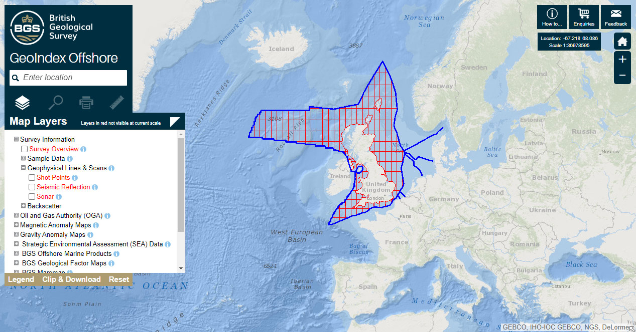

The GeoIndex Offshore interface. Contains GEBCO, IHO-IOC GEBCO, NGS and DeLorme data. BGS © UKRI.
Datasets are also available to view as a web map service (WMS), as are offshore marine information products. Open data can be accessed and downloaded via an API using OGCAPI-Features standards. You are able to filter and query on the properties to retrieve the exact data you need e.g.
Offshore Geology data in a bounding box
Offshore Strategic Environmental Assessment (SEA) Line Data which INTERSECTS a polygon area
Survey information attributes
- Survey data attributes describe information for coastal and marine surveys that resulted in the collection of data. They contain the location (outline polygon) and basic information about the survey, including the types of equipment deployed during a survey.
- Sample data attributes describe the information and data relating to offshore sampling activities.
- Activity data contains location information and metadata, plus links to scanned images of sample stations datasheets where available.
- Geochemical, geological, geotechnical and seabed sediment data includes observations and/or measurements.
- Geophysical data attributes describe information for offshore geophysical activities.
- The shot point layer contains only location information and metadata, whereas the survey line (seismic reflection and sonar) layers include information about the equipment types used on the line and links to scanned images of the geophysical records where the terms of use are available.
| COLUMN NAME | DATA TYPE | DESCRIPTION |
|---|---|---|
| CRUISE_ID | NUMBER | Unique identifier of a cruise record. |
| MDFILEID_NERC_GUID | TEXT | Unique identifier for the representation of the metadata, i.e. a different value is required for each metadata standard or version that the metadata is represented in. The value to output as MD_Metadata.fileIdentifier for representations of the metadata in NERC/GEMINI2/INSPIRE ISO 19139 xml files. |
| CRUISE | TEXT | Name by which a cruise is known. |
| CRUISE_DATA_URL | TEXT | Location of the survey data. |
| TERMS_OF_USE | TEXT | Terms under which the data can be used. |
| TERMS_OF_USE_URL | TEXT | Location of the terms of use. |
| CRUISE_ALIAS | TEXT | Alternative names by which an individual cruise may be identified. |
| RESTITLE | TEXT | Brief title for the cruise. |
| SHIP | TEXT | Name of the ship used on the survey. |
| CLIENT | TEXT | Name of the client for whom the cruise was undertaken. |
| CONTRACTOR | TEXT | Name of the contractor who undertook the cruise on behalf of the client. |
| CRUISE_AREA | TEXT | Name of the sea area(s) covered by the survey. Each group of sea areas is preceded by the category to which it belongs, e.g. Offshore 1:250K: Spurn. |
| ABSTRACT | TEXT | Brief description of the cruise. |
| ADDITIONAL_INFO | NUMBER | Any additional information relating to the acquisition techniques, operational standards and quality control of the survey data. |
| NAV_EQUIP_TYPE | TEXT | Type of navigation equipment used on the cruise. |
| GEOPHYS_EQUIP_TYPE | TEXT | Type of geophysical equipment used on the cruise. |
| SAMP_EQUIP_TYPE | TEXT | Type of sampling equipment used on the cruise. |
| START_DATE | DATE | Date on which the cruise commenced. |
| START_DATE_EST | TEXT | Whether the date on which the cruise commenced is actual or estimated. |
| END_DATE | DATE | Date on which the cruise ended. |
| END_DATE_EST | TEXT | Whether the date on which the cruise ended is actual or estimated. |
| CONFIDENTIALITY | TEXT | Confidentiality classification. |
| ACCESSUSE_RESTRIC | TEXT | Access and use restrictions. |
| SHAPE_WGS84 | SDO_GEOMETRY | Polygon in WGS84 (SRID=4326) of the cruise area. |
| COLUMN NAME | DATA TYPE | DESCRIPTION |
|---|---|---|
| ACTIVITY_ID | NUMBER | Unique identifier of a sampling activity record. |
| SAMPLE_NAME | TEXT | Unique name used to identify a sample/activity. It is a concatenation of the survey station identifier, the equipment code and the equipment attempt. |
| IMAGE_URL | TEXT | Location of the scanned image. |
| TERMS_OF_USE | TEXT | Terms under which the data can be used. |
| TERMS_OF_USE_URL | TEXT | Location of the terms of use. |
| SAMPLE_ALIAS | TEXT | Alternative name by which an activity may be identified. May have been used in literature or by an external organisation. |
| DGSQ | TEXT | One degree square of latitude and longitude defined by bottom south-west corner of the square. Format: e.g. +54-001 appended with a sequential accession number forms a unique identifier for a survey station such as +54-001/230. |
| NUM | NUMBER | Sequential accession number which is appended to the degree square to uniquely identify each survey station e.g. +54-001/123. |
| CRUISE | TEXT | Name by which a cruise is known. |
| SHIP | TEXT | Name of the ship used on the survey. |
| SOURCE_TITLE | TEXT | Title of either the associated survey or offshore report. |
| OFFSHORE_REPORT | TEXT | Report number from which details of the sample were obtained. |
| CLIENT | TEXT | If activity is linked to a cruise, client for whom the project was carried out. If activity is linked to a report, client for whom the report was produced. |
| CONTRACTOR | TEXT | If activity is linked to a cruise, contractor who undertook the project on behalf of the client. If activity is linked to a report, contractor who produced the report on behalf of the client. |
| EQUIPMENT_TYPE | TEXT | Type of equipment used for sampling. |
| EQUIPMENT_START_DATE | DATE | Date on which use of a specific piece of equipment began. |
| EQUIPMENT_ATTEMPT | NUMBER | Sequence number for the use of a specific piece of equipment at a particular survey station. There could be multiple attempts because of equipment failure or because of different operational requirements. |
| SUCCESS | TEXT | Success of an activity. Used to indicate if a sample has been recovered and if not reasons for failure. |
| RECOVERY_VOLUME | NUMBER | Volume recovered, generally from a grab or dredging device, in litres. |
| RECOVERY_VOLUME_UNITS | TEXT | Recovery volume units, litres. |
| SAMPLE_RETAINED | TEXT | Set to Y if the sample has been retained and N if the sample has been discarded after processing. |
| SEABED_PHOTO | TEXT | Set to Y if a seabed photo was taken at the site of the sampling activity. |
| EPSG_CODE | NUMBER | EPSG (OGP) code for the horizontal coordinate system. |
| EPSG | TEXT | Translation of the EPSG (OGP) code for the horizontal coordinate system. |
| X | NUMBER | The X coordinate. It may be lat/long, national grid, UTM, etc. |
| Y | NUMBER | The Y coordinate. It may be lat/long, national grid, UTM, etc. |
| XY_SOURCE | TEXT | Source of the X and Y coordinates. It should normally be the original value but may have been recalculated to give better accuracy. |
| X_ED50 | NUMBER | X coordinate using the ED50 coordinate system. |
| Y_ED50 | NUMBER | Y coordinate using the ED50 coordinate system. |
| X_WGS84 | NUMBER | X coordinate using the WGS84 coordinate system. |
| Y_WGS84 | NUMBER | Y coordinate using the WGS84 coordinate system. |
| X_BNG | NUMBER | Easting (X) using the British National Grid coordinate system. |
| Y_BNG | NUMBER | Northing (Y) using the British National Grid coordinate system. |
| DEPTH_UNITS | TEXT | Depth units, metres (to the nearest centimetre). |
| WATER_DEPTH | NUMBER | Water depth in metres. |
| DEPTH_DATUM | TEXT | Depth datum (vertical coordinate system). |
| DEPTH_SOURCE | TEXT | Source of the water depth. |
| TERMINAL_DEPTH | NUMBER | Maximum depth achieved by an activity in metres (to the nearest centimetre). |
| GEOL_SUMMARY | TEXT | Summary description of the sediments or bottom conditions encountered at a survey station. |
| ADDITIONAL_INFO | TEXT | Any additional information relating to a sampling activity e.g. collection methods, quality observations, limits or caveats on use, purpose of collection, relevant references. |
| CONFIDENTIALITY | TEXT | Confidentiality classification. |
| ACCESSUSE_RESTRIC | TEXT | Access and use restrictions. |
| RELEASE_DATE | DATE | Data release date, where set will determine settings of confidentiality and access and use restrictions. |
| SHAPE_WGS84 | SDO_GEOMETRY | Point in WGS84 (SRID=4326) derived from the X,Y coordinates of the sampling activity. |
| COLUMN NAME | DATA TYPE | DESCRIPTION |
|---|---|---|
| GEOLOGICAL_DATA_ID | NUMBER | Unique identifier of a geological data record. |
| ACTIVITY_ID | NUMBER | Unique identifier of a sampling activity. |
| SAMPLE_NAME | TEXT | Unique name used to identify a sample/activity. It is a concatenation of the survey station identifier, the equipment code and the equipment attempt. |
| TERMS_OF_USE | TEXT | Terms under which the data can be used. |
| TERMS_OF_USE_URL | TEXT | Location of the terms of use. |
| SAMPLE_ALIAS | TEXT | Alternative name by which an activity may be identified. May have been used in literature or by an external organisation. |
| SAMPLE_SOURCE | TEXT | Cruise or offshore report with which the activity is associated. |
| CLIENT | TEXT | If activity is linked to a cruise, client for whom the project was carried out. If activity is linked to a report, client for whom the report was produced. |
| CONTRACTOR | TEXT | If activity is linked to a cruise, contractor who undertook the project on behalf of the client. If activity is linked to a report, contractor who produced the report on behalf of the client. |
| EQUIPMENT_TYPE | TEXT | Type of equipment used for sampling. |
| EQUIPMENT_START_DATE | DATE | Date on which use of a specific piece of equipment began. |
| EPSG_CODE | NUMBER | EPSG (OGP) code for the horizontal coordinate system. |
| EPSG | TEXT | Translation of the EPSG (OGP) code for the horizontal coordinate system. |
| X | NUMBER | The X coordinate. It may be lat/long, national grid, UTM, etc. |
| Y | NUMBER | The Y coordinate. It may be lat/long, national grid, UTM, etc. |
| XY_SOURCE | TEXT | Source of the X and Y coordinates. It should normally be the original value but may have been recalculated to give better accuracy. |
| X_ED50 | NUMBER | X coordinate using the ED50 coordinate system. |
| Y_ED50 | NUMBER | Y coordinate using the ED50 coordinate system. |
| X_WGS84 | NUMBER | X coordinate using the WGS84 coordinate system. |
| Y_WGS84 | NUMBER | Y coordinate using the WGS84 coordinate system. |
| X_BNG | NUMBER | Easting (X) using the British National Grid coordinate system. |
| Y_BNG | NUMBER | Northing (Y) using the British National Grid coordinate system. |
| DEPTH_UNITS | TEXT | Depth units, metres (to the nearest centimetre). |
| WATER_DEPTH | NUMBER | Water depth in metres. |
| DEPTH_DATUM | TEXT | Depth datum (vertical coordinate system). |
| DEPTH_SOURCE | TEXT | Source of the water depth. |
| TERMINAL_DEPTH | NUMBER | Maximum depth achieved by an activity in metres (to the nearest centimetre). |
| UNIT_DEPTH_TOP | NUMBER | Upper depth of the lithological unit relative to the seabed in metres (to the nearest centimetre). |
| UNIT_DEPTH_BASE | NUMBER | Basal depth of the lithological unit relative to the seabed in metres (to the nearest centimetre). |
| UNIT_LENGTH | NUMBER | Length of the lithological unit in metres (to the nearest centimetre). |
| INTERP_SOURCE | TEXT | Source of the interpretation. |
| BASE_BED | TEXT | Base of bed, nature of the basal contact of a unit. |
| BED_TYPE | TEXT | Bedding type. |
| CGI_BED_TYPE | TEXT | Commission for the Management and Application of Geoscience Information (CGI) bedding type. |
| H2S_ODOUR | TEXT | H2S (hydrogen sulphide) odour presence. |
| JOINTING | TEXT | Jointing based on Bieniawski Geomechanics Classification. |
| HEAVY_MINERALS | TEXT | Heavy minerals presence. |
| MICA | TEXT | Mica presence. |
| GLAUCONITE | TEXT | Glauconite presence. |
| CALCAREOUS | TEXT | Calcareous mineral presence. |
| HCL_REACTION | TEXT | HCl reaction. |
| ROCK_CLASS_MAIN | TEXT | Main rock classification. |
| ROCK_CLASS_MINOR | TEXT | Minor rock classification. |
| CGI_SIMPLE_LITHOLOGY | TEXT | Commission for the Management and Application of Geoscience Information (CGI) simple lithology. |
| GRAIN_SIZE_MIN | TEXT | Visual estimate of the minimum grain size according to the Udden-Wentworth scale. |
| GRAIN_SIZE_MAX | TEXT | Visual estimate of the maximum grain size according to the Udden-Wentworth scale. |
| GRAIN_SIZE_MEAN | TEXT | Visual estimate of the mean grain size according to the Udden-Wentworth scale. |
| SAND_GRAIN_SIZE_MIN | TEXT | Minimum sand grain size. |
| SAND_GRAIN_SIZE_MAX | TEXT | Maximum sand grain size. |
| SORTING | TEXT | Sorting quality. |
| SAND_SPHERICITY | TEXT | Sand sphericity (high or low). |
| SAND_ROUNDNESS_MIN | TEXT | Minimum sand roundness. |
| SAND_ROUNDNESS_MAX | TEXT | Maximum sand roundness. |
| GRAVEL_PERC_SHELL | NUMBER | Percentage of the gravel fraction that is made up of shell material. |
| GRAVEL_PERC_SHELL_UNITS | TEXT | Units of measurement for percentage of the gravel fraction that is made up of shell material. |
| SAND_PERC_SHELL | NUMBER | Percentage of the sand fraction that is made up of shell material. |
| SAND_PERC_SHELL_UNITS | TEXT | Units of measurement for percentage of the sand fraction that is made up of shell material. |
| GRAVEL_MAX_CLAST_SIZE | NUMBER | Size of the biggest clast in the gravel fraction (in millimetres). |
| GRAVEL_MAX_CLAST_SIZE_UNITS | TEXT | Units of measurement for size of the biggest clast in the gravel fraction. |
| GRAVEL_SPHERICITY | TEXT | Gravel sphericity (high or low). |
| GRAVEL_ROUNDNESS_MIN | TEXT | Minimum gravel roundness. |
| GRAVEL_ROUNDNESS_MAX | TEXT | Maximum gravel roundness. |
| MUD_HARDNESS_MIN | TEXT | Minimum mud hardness. |
| MUD_HARDNESS_MAX | TEXT | Maximum mud hardness. |
| MUD_PLASTICITY_MIN | TEXT | Minimum mud plasticity. |
| MUD_PLASTICITY_MAX | TEXT | Maximum mud plasticity. |
| CHRONOSTRAT_MIN | TEXT | Minimum age chronostratigraphy. |
| CHRONOSTRAT_MAX | TEXT | Maximum age chronostratigraphy. |
| LITHOSTRAT | TEXT | Lithostratigraphy. |
| FAUNA_FOSSILS | TEXT | Fauna fossils presence. |
| WHOLE_SHELLS | TEXT | Whole shells presence. |
| FORAMS | TEXT | Foraminifera presence. |
| PLANT_REMAINS | TEXT | Plant remains presence. |
| BIOTURBATION | TEXT | Bioturbation index. |
| MUNSELL_CODE_MAIN | TEXT | Main munsell soil colour code. |
| MUNSELL_COLOUR_MAIN | TEXT | Main munsell soil colour. |
| MUNSELL_CODE_MINOR | TEXT | Minor munsell soil colour code. |
| MUNSELL_COLOUR_MINOR | TEXT | Minor munsell soil colour. |
| GEOLOGIST | TEXT | Geologist who described the geological data. |
| GEOL_DESC | TEXT | Geological description. |
| ADDITIONAL_INFO | TEXT | Any additional information. |
| CONFIDENTIALITY | TEXT | Confidentiality classification. |
| ACCESSUSE_RESTRIC | TEXT | Access and use restrictions. |
| SHAPE_WGS84 | SDO_GEOMETRY | Point in WGS84 (SRID=4326) derived from the X,Y coordinates of the sampling activity. |
| COLUMN NAME | DATA TYPE | DESCRIPTION |
|---|---|---|
| GEOTECHNICAL_DATA_ID | NUMBER | Unique identifier of a geotechnical data record. |
| ACTIVITY_ID | NUMBER | Unique identifier of a sampling activity. |
| SAMPLE_NAME | TEXT | Unique name used to identify a sample/activity. It is a concatenation of the survey station identifier, the equipment code and the equipment attempt. |
| TERMS_OF_USE | TEXT | Terms under which the data can be used. |
| TERMS_OF_USE_URL | TEXT | Location of the terms of use. |
| SAMPLE_ALIAS | TEXT | Alternative name by which an activity may be identified. May have been used in literature or by an external organisation. |
| SAMPLE_SOURCE | TEXT | Cruise or offshore report with which the activity is associated. |
| CLIENT | TEXT | If activity is linked to a cruise, client for whom the project was carried out. If activity is linked to a report, client for whom the report was produced. |
| CONTRACTOR | TEXT | If activity is linked to a cruise, contractor who undertook the project on behalf of the client. If activity is linked to a report, contractor who produced the report on behalf of the client. |
| EQUIPMENT_TYPE | TEXT | Type of equipment used for sampling. |
| EQUIPMENT_START_DATE | DATE | Date on which use of a specific piece of equipment began. |
| EPSG_CODE | NUMBER | EPSG (OGP) code for the horizontal coordinate system. |
| EPSG | TEXT | Translation of the EPSG (OGP) code for the horizontal coordinate system. |
| X | NUMBER | The X coordinate. It may be lat/long, national grid, UTM, etc. |
| Y | NUMBER | The Y coordinate. It may be lat/long, national grid, UTM, etc. |
| XY_SOURCE | TEXT | Source of the X and Y coordinates. It should normally be the original value but may have been recalculated to give better accuracy. |
| X_ED50 | NUMBER | X coordinate using the ED50 coordinate system. |
| Y_ED50 | NUMBER | Y coordinate using the ED50 coordinate system. |
| X_WGS84 | NUMBER | X coordinate using the WGS84 coordinate system. |
| Y_WGS84 | NUMBER | Y coordinate using the WGS84 coordinate system. |
| X_BNG | NUMBER | Easting (X) using the British National Grid coordinate system. |
| Y_BNG | NUMBER | Northing (Y) using the British National Grid coordinate system. |
| DEPTH_UNITS | TEXT | Depth units, metres (to the nearest centimetre). |
| WATER_DEPTH | NUMBER | Water depth in metres. |
| DEPTH_DATUM | TEXT | Depth datum (vertical coordinate system). |
| DEPTH_SOURCE | TEXT | Source of the water depth. |
| TERMINAL_DEPTH | NUMBER | Maximum depth achieved by an activity in metres (to the nearest centimetre). |
| MEAS_DEPTH | NUMBER | Depth of reading relative to the seabed in metres (to the nearest centimetre). |
| MEAS_SOURCE | TEXT | Source of the measurement. |
| MEAS_ORIENTATION | TEXT | Measurement orientation (vertical, horizontal or unknown). |
| SHEAR_STRENGTH | NUMBER | Shear strength, the average of the hand vane readings multiplied by the conversion factor (in kPa). |
| SHEAR_STRENGTH_UNITS | TEXT | Units of measurement for SHEAR_STRENGTH, kPa. |
| COMPR_STRENGTH | NUMBER | Compressive strength, the average of the penetrometer head readings multiplied by the conversion factor (in kPa). |
| COMPR_STRENGTH_UNITS | TEXT | Units of measurement for COMPR_STRENGTH, kPa. |
| MOISTURE_CONTENT | NUMBER | Ratio of the mass of water to the mass of solids, expressed as a percentage. |
| MOISTURE_CONTENT_UNITS | TEXT | Units of measurement for MOISTURE_CONTENT, per cent. |
| PLASTIC_LIMIT | NUMBER | Moisture content where the thread breaks apart at a diameter of 3.2 mm (about 1/8 inch), expressed as a percentage. |
| PLASTIC_LIMIT_UNITS | TEXT | Units of measurement for PLASTIC_LIMIT, per cent. |
| LIQUID_LIMIT | NUMBER | Liquid limit (LL) is conceptually defined as the water content at which the behavior of a clayey soil changes from plastic to liquid, expressed as percentage. |
| LIQUID_LIMIT_UNITS | TEXT | Units of measurement for LIQUID_LIMIT, per cent. |
| PLASTICITY_INDEX | NUMBER | Plasticity index (PI) is a measure of the plasticity of a soil. The plasticity index is the size of the range of water contents where the soil exhibits plastic properties, expressed as percentage. |
| PLASTICITY_INDEX_UNITS | TEXT | Units of measurement for PLASTICITY_INDEX, per cent. |
| SOIL_ACTIVITY | NUMBER | Plasticity index divided by the percent of clay–sized particles (less than 2 μm) present. Different types of clays have different specific surface areas which controls how much wetting is required to move a soil from one phase to another such as across the liquid limit or the plastic limit. From the activity, one can predict the dominant clay type present in a soil sample. |
| LIQUIDITY_INDEX | NUMBER | Liquidity index (LI) is used for scaling the natural water content of a soil sample to the limits. |
| BULK_DENSITY | NUMBER | Total mass of air, water, solids divided by the total volume of air water and solids, expressed as mg/m3. |
| BULK_DENSITY_UNITS | TEXT | Units of measurement for BULK_DENSITY, mg/m3. |
| DRY_DENSITY | NUMBER | Mass of solids divided by the total volume of air water and solids, expressed as mg/m3. |
| DRY_DENSITY_UNITS | TEXT | Units of measurement for DRY_DENSITY, mg/m3. |
| SATURATED_DENSITY | NUMBER | Bulk density of the soil when it is fully saturated, expressed as mg/m3. |
| SATURATED_DENSITY_UNITS | TEXT | Units of measurement for SATURATED_DENSITY, mg/m3. |
| VOIDS_RATIO | NUMBER | Ratio of the volume of voids to the volume of solid particles in a soil mass. |
| POROSITY | NUMBER | Ratio of the volume of voids (containing air, water, or other fluids) in a soil to the total volume of the soil, expressed as either percentage or fraction. |
| POROSITY_UNITS | TEXT | Units of measurement for POROSITY, per cent or fraction. |
| DEG_SATURATION | NUMBER | Ratio of the volume of water to the volume of voids, expressed as percentage. |
| DEG_SATURATION_UNITS | TEXT | Units of measurement for DEG_SATURATION, per cent. |
| SPECIFIC_GRAVITY | NUMBER | Ratio of the density of the sample to the density of water. |
| ADDITIONAL_INFO | TEXT | Any additional information. |
| CONFIDENTIALITY | TEXT | Confidentiality classification. |
| ACCESSUSE_RESTRIC | TEXT | Access and use restrictions. |
| SHAPE_WGS84 | SDO_GEOMETRY | Point in WGS84 (SRID=4326) derived from the X,Y coordinates of the sampling activity. |
| COLUMN NAME | DATA TYPE | DESCRIPTION |
|---|---|---|
| GEOCHEMICAL_DATA_ID | NUMBER | Unique identifier of a geochemical data record. |
| ACTIVITY_ID | NUMBER | Unique identifier of a sampling activity. |
| SAMPLE_NAME | TEXT | Unique name used to identify a sample/activity. It is a concatenation of the survey station identifier, the equipment code and the equipment attempt. |
| TERMS_OF_USE | TEXT | Terms under which the data can be used. |
| TERMS_OF_USE_URL | TEXT | Location of the terms of use. |
| SAMPLE_ALIAS | TEXT | Alternative name by which an activity may be identified. May have been used in literature or by an external organisation. |
| SAMPLE_SOURCE | TEXT | Cruise or offshore report with which the activity is associated. |
| CLIENT | TEXT | If activity is linked to a cruise, client for whom the project was carried out. If activity is linked to a report, client for whom the report was produced. |
| CONTRACTOR | TEXT | If activity is linked to a cruise, contractor who undertook the project on behalf of the client. If activity is linked to a report, contractor who produced the report on behalf of the client. |
| EQUIPMENT_TYPE | TEXT | Type of equipment used for sampling. |
| EQUIPMENT_START_DATE | DATE | Date on which use of a specific piece of equipment began. |
| EPSG_CODE | NUMBER | EPSG (OGP) code for the horizontal coordinate system. |
| EPSG | TEXT | Translation of the EPSG (OGP) code for the horizontal coordinate system. |
| X | NUMBER | The X coordinate. It may be lat/long, national grid, UTM, etc. |
| Y | NUMBER | The Y coordinate. It may be lat/long, national grid, UTM, etc. |
| XY_SOURCE | TEXT | Source of the X and Y coordinates. It should normally be the original value but may have been recalculated to give better accuracy. |
| X_ED50 | NUMBER | X coordinate using the ED50 coordinate system. |
| Y_ED50 | NUMBER | Y coordinate using the ED50 coordinate system. |
| X_WGS84 | NUMBER | X coordinate using the WGS84 coordinate system. |
| Y_WGS84 | NUMBER | Y coordinate using the WGS84 coordinate system. |
| X_BNG | NUMBER | Easting (X) using the British National Grid coordinate system. |
| Y_BNG | NUMBER | Northing (Y) using the British National Grid coordinate system. |
| DEPTH_UNITS | TEXT | Depth units, metres (to the nearest centimetre). |
| WATER_DEPTH | NUMBER | Water depth in metres. |
| DEPTH_DATUM | TEXT | Depth datum (vertical coordinate system). |
| DEPTH_SOURCE | TEXT | Source of the water depth. |
| TERMINAL_DEPTH | NUMBER | Maximum depth achieved by an activity in metres (to the nearest centimetre). |
| ANALYSIS_SOURCE | TEXT | Source of the analysis. |
| LI_PPM | NUMBER | Lithium (ppm) |
| BE_PPM | NUMBER | Beryllium (ppm) |
| B_PPM | NUMBER | Boron (ppm) |
| MGO_PER | NUMBER | Magnesium (per cent) |
| AL2O3_PER | NUMBER | Aluminium (per cent) |
| SIO2_PER | NUMBER | Silicon (per cent) |
| P_PER | NUMBER | Phosphorus (per cent) |
| K2O_PER | NUMBER | Potassium (per cent) |
| CAO_PER | NUMBER | Calcium (per cent) |
| SC_PPM | NUMBER | Scandium (ppm) |
| TIO2_PER | NUMBER | Titanium (per cent) |
| V_PPM | NUMBER | Vanadium (ppm) |
| CR_PPM | NUMBER | Chromium (ppm) |
| MN_PER | NUMBER | Manganese (per cent) |
| FE2O3_PER | NUMBER | Iron (per cent) |
| CO_PPM | NUMBER | Cobalt (ppm) |
| NI_PPM | NUMBER | Nickel (ppm) |
| CU_PPM | NUMBER | Copper (ppm) |
| ZN_PPM | NUMBER | Zinc (ppm) |
| GA_PPM | NUMBER | Gallium (ppm) |
| GE_PPM | NUMBER | Germanium (ppm) |
| RB_PPM | NUMBER | Rubidium (ppm) |
| SR_PPM | NUMBER | Strontium (ppm) |
| Y_PPM | NUMBER | Yttrium (ppm) |
| ZR_PPM | NUMBER | Zirconium (ppm) |
| NB_PPM | NUMBER | Niobium (ppm) |
| MO_PPM | NUMBER | Molybdenum (ppm) |
| AG_PPM | NUMBER | Silver (ppm) |
| CD_PPM | NUMBER | Cadmium (ppm) |
| SN_PPM | NUMBER | Strontium (ppm) |
| BA_PPM | NUMBER | Barium (ppm) |
| LA_PPM | NUMBER | Lanthanum (ppm) |
| CE_PPM | NUMBER | Cerium (ppm) |
| ND_PPM | NUMBER | Neodymium (ppm) |
| HG_PPM | NUMBER | Mercury (ppm) |
| PB_PPM | NUMBER | Lead (ppm) |
| BI_PPM | NUMBER | Bismuth (ppm) |
| U_PPM | NUMBER | Uranium (ppm) |
| CONFIDENTIALITY | TEXT | Confidentiality classification. |
| ACCESSUSE_RESTRIC | TEXT | Access and use restrictions. |
| SHAPE_WGS84 | SDO_GEOMETRY | Point in WGS84 (SRID=4326) derived from the X,Y coordinates of the sampling activity. |
| COLUMN NAME | DATA TYPE | DESCRIPTION |
|---|---|---|
| PSA_DATA_ID | NUMBER | Unique identifier of a particle size analysis data record. |
| ACTIVITY_ID | NUMBER | Unique identifier of a sampling activity. |
| SAMPLE_NAME | TEXT | Unique name used to identify a sample/activity. It is a concatenation of the survey station identifier, the equipment code and the equipment attempt. |
| TERMS_OF_USE | TEXT | Terms under which the data can be used. |
| TERMS_OF_USE_URL | TEXT | Location of the terms of use. |
| SAMPLE_ALIAS | TEXT | Alternative name by which an activity may be identified. May have been used in literature or by an external organisation. |
| SAMPLE_SOURCE | TEXT | Cruise or offshore report with which the activity is associated. |
| CLIENT | TEXT | If activity is linked to a cruise, client for whom the project was carried out. If activity is linked to a report, client for whom the report was produced. |
| CONTRACTOR | TEXT | If activity is linked to a cruise, contractor who undertook the project on behalf of the client. If activity is linked to a report, contractor who produced the report on behalf of the client. |
| EQUIPMENT_TYPE | TEXT | Type of equipment used for sampling. |
| EQUIPMENT_START_DATE | DATE | Date on which use of a specific piece of equipment began. |
| EPSG_CODE | NUMBER | EPSG (OGP) code for the horizontal coordinate system. |
| EPSG | TEXT | Translation of the EPSG (OGP) code for the horizontal coordinate system. |
| X | NUMBER | The X coordinate. It may be lat/long, national grid, UTM, etc. |
| Y | NUMBER | The Y coordinate. It may be lat/long, national grid, UTM, etc. |
| XY_SOURCE | TEXT | Source of the X and Y coordinates. It should normally be the original value but may have been recalculated to give better accuracy. |
| X_ED50 | NUMBER | X coordinate using the ED50 coordinate system. |
| Y_ED50 | NUMBER | Y coordinate using the ED50 coordinate system. |
| X_WGS84 | NUMBER | X coordinate using the WGS84 coordinate system. |
| Y_WGS84 | NUMBER | Y coordinate using the WGS84 coordinate system. |
| X_BNG | NUMBER | Easting (X) using the British National Grid coordinate system. |
| Y_BNG | NUMBER | Northing (Y) using the British National Grid coordinate system. |
| DEPTH_UNITS | TEXT | Depth units, metres (to the nearest centimetre). |
| WATER_DEPTH | NUMBER | Water depth in metres. |
| DEPTH_DATUM | TEXT | Depth datum (vertical coordinate system). |
| DEPTH_SOURCE | TEXT | Source of the water depth. |
| TERMINAL_DEPTH | NUMBER | Maximum depth achieved by an activity in metres (to the nearest centimetre). |
| DEPTH_TOP | NUMBER | Upper depth relative to the sea bed in metres (to the nearest centimetre). |
| DEPTH_BASE | NUMBER | Lower depth relative to the sea bed in metres (to the nearest centimetre). |
| ANALYSIS_SOURCE | TEXT | Source of the analysis. |
| FOLK_CLASS | TEXT | Abbreviation by which the folk classification is known. |
| FOLK | TEXT | Description of the folk classification. |
| WEIGHT | NUMBER | Total weight of sample, grams. |
| WEIGHT_UNITS | TEXT | Weight units, grams. |
| GRAV | NUMBER | Percentage gravel. |
| SAND | NUMBER | Percentage sand. |
| MUD | NUMBER | Percentage mud. |
| GSM_UNITS | TEXT | Gravel, sand and mud units, per cent. |
| TGRAV | NUMBER | Weight of gravel used in carbonate test, grams. |
| CGRAV | NUMBER | Percentage carbonate in gravel. |
| TSAND | NUMBER | Weight of sand used in carbonate test, grams. |
| CSAND | NUMBER | Percentage carbonate in sand. |
| TMUD | NUMBER | Weight of mud used in carbonate test, grams. |
| CMUD | NUMBER | Percentage carbonate in mud. |
| CTOT | NUMBER | Percentage carbonate in total sample. |
| CARBONATE_UNITS | TEXT | Carbonate units, percent. |
| PHI_MI_6_5 | NUMBER | Sediment that has passed through the -7.0 phi sieve and has been retained by the -6.5 phi sieve, or equivalent (90 510–128 000 micron). |
| PHI_MI_6_0 | NUMBER | Sediment that has passed through the -6.5 phi sieve and has been retained by the -6.0 phi sieve, or equivalent (64 000–90 510 micron). |
| PHI_MI_6 | NUMBER | Sediment that has passed through the -7.0 phi sieve and has been retained by the -6.0 phi sieve, or equivalent (64 000–128 000 micron). |
| PHI_MI_5_5 | NUMBER | Sediment that has passed through the -6.0 phi sieve and has been retained by the -5.5 phi sieve, or equivalent (45 255–64 000 micron). |
| PHI_MI_5_0 | NUMBER | Sediment that has passed through the -5.5 phi sieve and has been retained by the -5.0 phi sieve, or equivalent (32 000–45 255 micron). |
| PHI_MI_5 | NUMBER | Sediment that has passed through the -6.0 phi sieve and has been retained by the -5.0 phi sieve, or equivalent (32 000–64 000 micron). |
| PHI_MI_4_5 | NUMBER | Sediment that has passed through the -5.0 phi sieve and has been retained by the -4.5 phi sieve, or equivalent (22 627–32 000 micron). |
| PHI_MI_4_0 | NUMBER | Sediment that has passed through the -4.5 phi sieve and has been retained by the -4.0 phi sieve, or equivalent (16 000–22 627 micron). |
| PHI_MI_4 | NUMBER | Sediment that has passed through the -5.0 phi sieve and has been retained by the -4.0 phi sieve, or equivalent (16 000–32 000 micron). |
| PHI_MI_3_5 | NUMBER | Sediment that has passed through the -4.0 phi sieve and has been retained by the -3.5 phi sieve, or equivalent (11 314–16 000 micron). |
| PHI_MI_3_0 | NUMBER | Sediment that has passed through the -3.5 phi sieve and has been retained by the -3.0 phi sieve, or equivalent (8000–11 314 micron). |
| PHI_MI_3 | NUMBER | Sediment that has passed through the -4.0 phi sieve and has been retained by the -3.0 phi sieve, or equivalent (8000–16000 micron). |
| PHI_MI_2_5 | NUMBER | Sediment that has passed through the -3.0 phi sieve and has been retained by the -2.5 phi sieve, or equivalent (5657–8000 micron). |
| PHI_MI_2_0 | NUMBER | Sediment that has passed through the -2.5 phi sieve and has been retained by the -2.0 phi sieve, or equivalent (4000–5657 micron). |
| PHI_MI_2 | NUMBER | Sediment that has passed through the -3.0 phi sieve and has been retained by the -2.0 phi sieve, or equivalent (4000–8000 micron). |
| PHI_MI_1_5 | NUMBER | Sediment that has passed through the -2.0 phi sieve and has been retained by the -1.5 phi sieve, or equivalent (2828–4000 micron). |
| PHI_MI_1_0 | NUMBER | Sediment that has passed through the -1.5 phi sieve and has been retained by the -1.0 phi sieve, or equivalent (2000–2828 micron). |
| PHI_MI_1 | NUMBER | Sediment that has passed through the -2.0 phi sieve and has been retained by the -1.0 phi sieve, or equivalent (2000–4000 micron). |
| PHI_MI_0_5 | NUMBER | Sediment that has passed through the -1.0 phi sieve and has been retained by the -0.5 phi sieve, or equivalent (1414–2000 micron). |
| PHI_MI_0_25 | NUMBER | Sediment that has passed through the -0.5 phi sieve and has been retained by the -0.25 phi sieve, or equivalent (1189–1414 micron). |
| PHI_0 | NUMBER | Sediment that has passed through the -1.0 phi sieve and has been retained by the 0.0 phi sieve, or equivalent (1000–2000 micron). The range is the very coarse sand fraction according to the Wentworth classification. |
| PHI_0_0 | NUMBER | Sediment that has passed through the -0.5 phi sieve and has been retained by the 0.0 phi sieve, or equivalent (1000–1414 micron). |
| PHI_0_5 | NUMBER | Sediment that has passed through the 0.0 phi sieve and has been retained by the 0.5 phi sieve, or equivalent (707–1000 micron). |
| PHI_1 | NUMBER | Sediment that has passed through the 0.0 phi sieve and has been retained by the 1.0 phi sieve, or equivalent (500–1000 micron). The range is the coarse sand fraction according to the Wentworth classification. |
| PHI_1_0 | NUMBER | Sediment that has passed through the 0.5 phi sieve and has been retained by the 1.0 phi sieve, or equivalent (500–707 micron). |
| PHI_1_5 | NUMBER | Sediment that has passed through the 1.0 phi sieve and has been retained by the 1.5 phi sieve, or equivalent (354–500 micron). |
| PHI_2 | NUMBER | Sediment that has passed through the 1.0 phi sieve and has been retained by the 2.0 phi sieve, or equivalent (250–500 micron). The range is the medium sand fraction according to the Wentworth classification. |
| PHI_2_0 | NUMBER | Sediment that has passed through the 1.5 phi sieve and has been retained by the 2.0 phi sieve, or equivalent (250–354 micron). |
| PHI_2_5 | NUMBER | Sediment that has passed through the 2.0 phi sieve and has been retained by the 2.5 phi sieve, or equivalent (177–250 micron). |
| PHI_3 | NUMBER | Sediment that has passed through the 2.0 phi sieve and has been retained by the 3.0 phi sieve, or equivalent (125–250 micron). The range is the fine sand fraction according to the Wentworth classification. |
| PHI_3_0 | NUMBER | Sediment that has passed through the 2.5 phi sieve and has been retained by the 3.0 phi sieve, or equivalent (125–177 micron). |
| PHI_3_5 | NUMBER | Sediment that has passed through the 3.0 phi sieve and has been retained by the 3.5 phi sieve, or equivalent (88–125 micron). |
| PHI_3_75 | NUMBER | Sediment that has passed through the 3.5 phi sieve and has been retained by the 3.75 phi sieve, or equivalent (74–88 micron). |
| PHI_4 | NUMBER | Sediment that has passed through the 3.0 phi sieve and has been retained by the 4.0 phi sieve, or equivalent (62.5–125 micron). The range is the very fine sand fraction according to the Wentworth classification. |
| PHI_4_0 | NUMBER | Sediment that has passed through the 3.5 phi sieve and has been retained by the 4.0 phi sieve, or equivalent (62.5–88 micron). |
| PHI_4_5 | NUMBER | Sediment that has passed through the 4.0 phi sieve and has been retained by the 4.5 phi sieve, or equivalent (44.2–62.5 micron). |
| PHI_5 | NUMBER | Sediment that has passed through the 4.0 phi sieve and has been retained by the 5.0 phi sieve, or equivalent (31.25–62.5 micron). The range is the coarse silt fraction according to the Wentworth classification. |
| PHI_5_0 | NUMBER | Sediment that has passed through the 4.5 phi sieve and has been retained by the 5.0 phi sieve, or equivalent (31.25–44.2 micron). |
| PHI_5_5 | NUMBER | Sediment that has passed through the 5.0 phi sieve and has been retained by the 5.5 phi sieve, or equivalent (22–31.25 micron). |
| PHI_6 | NUMBER | Sediment that has passed through the 5.0 phi sieve and has been retained by the 6.0 phi sieve, or equivalent (15.6–31.25 micron). The range is the medium silt fraction according to the Wentworth classification. |
| PHI_6_0 | NUMBER | Sediment that has passed through the 5.5 phi sieve and has been retained by the 6.0 phi sieve, or equivalent (15.6–22 micron). |
| PHI_6_5 | NUMBER | Sediment that has passed through the 6.0 phi sieve and has been retained by the 6.5 phi sieve, or equivalent (11–15.6 micron). |
| PHI_7 | NUMBER | Sediment that has passed through the 6.0 phi sieve and has been retained by the 7.0 phi sieve, or equivalent (7.8–15.6 micron). The range is the fine silt fraction according to the Wentworth classification. |
| PHI_7_0 | NUMBER | Sediment that has passed through the 6.5 phi sieve and has been retained by the 7.0 phi sieve, or equivalent (7.8–11 micron). |
| PHI_7_5 | NUMBER | Sediment that has passed through the 7.0 phi sieve and has been retained by the 7.5 phi sieve, or equivalent (5.5–7.8 micron). |
| PHI_8 | NUMBER | Sediment that has passed through the 7.0 phi sieve and has been retained by the 8.0 phi sieve, or equivalent (3.9–7.8 micron). The range is the very fine silt fraction according to the Wentworth classification. |
| PHI_8_0 | NUMBER | Sediment that that has passed through the 7.5 phi sieve and has been retained by the 8.0 phi sieve, or equivalent (3.9–5.5 micron). |
| PHI_8_5 | NUMBER | Sediment that has passed through the 8.0 phi sieve and has been retained by the 8.5 phi sieve, or equivalent (2.76–3.9 micron). |
| PHI_9 | NUMBER | Sediment that has passed through the 8.0 phi sieve and has been retained by the 9.0 phi sieve, or equivalent (2–3.9 micron). |
| PHI_9_0 | NUMBER | Sediment that has passed through the 8.5 phi sieve and has been retained by the 9.0 phi sieve, or equivalent (2–2.76 micron). |
| PHI_9_5 | NUMBER | Sediment that has passed through the 9.0 phi sieve and has been retained by the 9.5 phi sieve, or equivalent (1.38–2 micron). |
| PHI_10 | NUMBER | Sediment that has passed through the 9.0 phi sieve and has been retained by the 10.0 phi sieve, or equivalent (0.98–2 micron). |
| PHI_10_0 | NUMBER | Sediment that has passed through the 9.5 phi sieve and has been retained by the 10.0 phi sieve, or equivalent (0.98–1.38 micron). |
| PHI_10_5 | NUMBER | Sediment that has passed through the 10.0 phi sieve and has been retained by the 10.5 phi sieve, or equivalent (0.69–0.98 micron). |
| PHI_11 | NUMBER | Sediment that has passed through the 10.0 phi sieve and has been retained by the 11.0 phi sieve, or equivalent (0.49–0.98 micron). |
| PHI_11_0 | NUMBER | Sediment that has passed through the 10.5 phi sieve and has been retained by the 11.0 phi sieve, or equivalent (0.49–0.69 micron). |
| PHI_11_5 | NUMBER | Sediment that has passed through the 11.0 phi sieve and has been retained by the 11.5 phi sieve, or equivalent (0.35–0.49 micron). |
| PHI_12 | NUMBER | Sediment that has passed through the 11.0 phi sieve and has been retained by the 12.0 phi sieve, or equivalent (0.25–0.49 micron). |
| PHI_12_0 | NUMBER | Sediment that has passed through the 11.5 phi sieve and has been retained by the 12.0 phi sieve, or equivalent (0.25–0.35 micron). |
| PHI_12_5 | NUMBER | Sediment that has passed through the 12.0 phi sieve and has been retained by the 12.5 phi sieve, or equivalent (0.175–0.25 micron). |
| PHI_13 | NUMBER | Sediment that has passed through the 12.0 phi sieve and has been retained by the 13.0 phi sieve, or equivalent (0.125–0.25 micron). |
| PHI_13_0 | NUMBER | Sediment that has passed through the 12.5 phi sieve and has been retained by the 13.0 phi sieve, or equivalent (0.125–0.175 micron). |
| PHI_13_5 | NUMBER | Sediment that has passed through the 13.0 phi sieve and has been retained by the 13.5 phi sieve, or equivalent (0.085–0.125 micron). |
| PHI_14 | NUMBER | Sediment that has passed through the 13.0 phi sieve and has been retained by the 14.0 phi sieve, or equivalent (0.06–01.25 micron). |
| PHI_14_0 | NUMBER | Sediment that has passed through the 13.5 phi sieve and has been retained by the 14.0 phi sieve, or equivalent (0.06–0.085 micron). |
| PHI_14_5 | NUMBER | Sediment that has passed through the 14.0 phi sieve and has been retained by the 14.5 phi sieve, or equivalent (0.04–0.06 micron). |
| PHI_UNITS | TEXT | PHI units, either grams or percent. |
| ADDITIONAL_INFO | TEXT | Any additional information relating to the particle size analysis e.g. quality control, standards. |
| CONFIDENTIALITY | TEXT | Confidentiality classification. |
| ACCESSUSE_RESTRIC | TEXT | Access and use restrictions. |
| SHAPE_WGS84 | SDO_GEOMETRY | Point in WGS84 (SRID=4326) derived from the X,Y coordinates of the sampling activity. |
| COLUMN NAME | DATA TYPE | DESCRIPTION |
|---|---|---|
| SVY_LINE_ID | NUMBER | Unique identifier of a survey line record. |
| CRUISE_DATA_URL | TEXT | Location of the survey data. |
| CRUISE_LINE | TEXT | Combination of the name by which the cruise and line is known separated by a hash (‘#’) symbol. |
| SCAN_URL | TEXT | Location of the scanned image. |
| SCAN_INFORMATION | TEXT | Additional information relating to the scanned image. |
| TERMS_OF_USE | TEXT | Terms under which the data can be used. |
| TERMS_OF_USE_URL | TEXT | Location of the terms of use. |
| CRUISE | TEXT | Name by which a cruise is known. |
| SVY_LINE | TEXT | Name by which a line is known. |
| CLIENT | TEXT | Name of the client for whom the cruise was undertaken. |
| CONTRACTOR | TEXT | Name of the contractor who undertook the cruise on behalf of the client. |
| GEOPHYS_EQUIP | TEXT | Geophysical equipment type used on a line. |
| ADDITIONAL_INFO | TEXT | Any additional information relating to the geophysical equipment type used on a line. |
| LINE_LENGTH | NUMBER | Length of the survey line calculated from SHAPE_WGS84 to the nearest kilometre. |
| LINE_LENGTH_UNITS | TEXT | Line length units, kilometres. |
| EPSG_CODE | TEXT | EPSG (OGP) code for the horizontal coordinate system. |
| EPSG | TEXT | Translation of the EPSG (OGP) code for the horizontal coordinate system. |
| START_X | NUMBER | The X coordinate at the line start. It may be lat/long, national grid, UTM, etc. |
| START_Y | NUMBER | The Y coordinate at the line start. It may be lat/long, national grid, UTM, etc. |
| START_DATETIME | DATE | Date and time of the start of the survey line where available. |
| END_X | NUMBER | The X coordinate at the line end. It may be lat/long, national grid, UTM, etc. |
| END_Y | NUMBER | The Y coordinate at the line end. It may be lat/long, national grid, UTM, etc. |
| END_DATETIME | DATE | Date and time of the end of the survey line where available. |
| START_X_ED50 | NUMBER | X coordinate of the start point of the line using the ED50 coordinate system. |
| START_Y_ED50 | NUMBER | Y coordinate of the start point of the line using the ED50 coordinate system. |
| END_X_ED50 | NUMBER | X coordinate of the end point of the line using the ED50 coordinate system. |
| END_Y_ED50 | NUMBER | Y coordinate of the end point of the line using the ED50 coordinate system. |
| START_X_WGS84 | NUMBER | X coordinate of the start point of the line using the WGS84 coordinate system. |
| START_Y_WGS84 | NUMBER | Y coordinate of the start point of the line using the WGS84 coordinate system. |
| END_X_WGS84 | NUMBER | X coordinate of the end point of the line using the WGS84 coordinate system. |
| END_Y_WGS84 | NUMBER | Y coordinate of the end point of the line using the WGS84 coordinate system. |
| START_X_BNG | NUMBER | Easting (X) of the start point of the line using the British National Grid coordinate system. |
| START_Y_BNG | NUMBER | Northing (Y) of the start point of the line using the British National Grid coordinate system. |
| END_X_BNG | NUMBER | Easting (X) of the end point of the line using the British National Grid coordinate system. |
| END_Y_BNG | NUMBER | Northing (Y) of the end point of the line using the British National Grid coordinate system. |
| CONFIDENTIALITY | TEXT | Confidentiality classification. |
| ACCESSUSE_RESTRIC | TEXT | Access and use restrictions. |
| QUALITY_ASSESSMENT | TEXT | Quality assessment of the data for the geophysical equipment type used on a line, either high, low, acceptable. |
| RELEASE_DATE | DATE | Data release date, where set will determine settings of confidentiality and access and use restrictions. |
| SHAPE_WGS84 | SDO_GEOMETRY | Line in WGS84 (SRID=4326) derived from the X,Y coordinates of the survey line. |
| COLUMN NAME | DATA TYPE | DESCRIPTION |
|---|---|---|
| SVY_LINE_PT_ID | NUMBER | Unique identifier of a survey line point record. |
| SVY_LINE_ID | NUMBER | Unique identifier of a survey line. |
| CRUISE | TEXT | Name by which a cruise is known. |
| SVY_LINE | TEXT | Name by which a line is known. |
| CRUISE_LINE | TEXT | Combination of the name by which the cruise and line is known separated by a hash symbol (#) . |
| FIX | NUMBER | Fix. |
| SUBFIX | NUMBER | Subfix. |
| DATETIME | DATE | Date and time (to the nearest second) of the fix. |
| EPSG_CODE | TEXT | EPSG (OGP) code for the horizontal coordinate system. |
| EPSG | TEXT | Translation of the EPSG (OGP) code for the horizontal coordinate system. |
| X | NUMBER | The X coordinate. It may be lat/long, national grid, UTM, etc. |
| Y | NUMBER | The Y coordinate. It may be lat/long, national grid, UTM, etc. |
| XY_SOURCE | TEXT | Source of the X and Y coordinates. It should normally be the original value but may have been recalculated to give better accuracy. |
| X_ED50 | NUMBER | X coordinate using the ED50 coordinate system. |
| Y_ED50 | NUMBER | Y coordinate using the ED50 coordinate system. |
| X_WGS84 | NUMBER | X coordinate using the WGS84 coordinate system. |
| Y_WGS84 | NUMBER | Y coordinate using the WGS84 coordinate system. |
| X_BNG | NUMBER | Easting (X) using the British National Grid coordinate system. |
| Y_BNG | NUMBER | Northing (Y) using the British National Grid coordinate system. |
| WATER_DEPTH | NUMBER | Water depth in metres. |
| WATER_DEPTH_UNITS | TEXT | Depth units, metres (to the nearest centimetre). |
| DEPTH_ACCURACY | NUMBER | Accuracy of the depth in metres. |
| DEPTH_SOURCE | TEXT | Source of the water depth. |
| SHAPE_WGS84 | SDO_GEOMETRY | Point in WGS84 (SRID=4326) derived from the X,Y coordinates of the survey line point. |
Hydrocarbon well attributes
| COLUMN NAME | DATA TYPE | DESCRIPTION |
| WELLID | NUMBER | Unique identifier of an offshore well. |
| WELLNAME | TEXT | Well registration number defined by OGA Petroleum Operations Notice No. 12. |
| DETAILS | TEXT | Link to the core sample results including photos where available. |
| DEN_NUMBER | TEXT | Unique number assigned to the well by OGA. |
| LICENCE | TEXT | The original licence number under which drilling of the well was authorised. |
| QUADRANT | TEXT | The UKCS quadrant in which the well is located. |
| BLOCK | TEXT | The UKCS shelf block in which the well is located |
| BLOCK_SUFFIX | TEXT | Block suffix letter (if any). |
| FIELDNAME | TEXT | The name of the hydrocarbon field in which the well is located |
| SPUD_DATE | DATE | The date the well was spudded or sidetracked. |
| COMPLETION_DATE | DATE | The date the well was left in one of three mechanical states, either completed for production, suspended or abandoned. |
| TD_DATE | DATE | The date on which drilling reached (or is planned to reach) the total depth of the well. |
| RELEASE_DATE | DATE | The date on which the confidentiality period of a well ends. |
| WELL_CLASS | TEXT | The original operator’s purpose in drilling the well, either appraisal, development or exploration. |
| WELL_STATUS | TEXT | The current mechanical status of the well, either drilling, completed, suspended or plugged and abandoned. |
| CURRENT_OWNER | TEXT | The current (or most recent) operating licensee as nominated under a Joint Operating Agreement (or similar). |
| ORIGINAL_OPERATOR | TEXT | The licensee who operated the well at the time it was actually drilled. |
| DATUM_ELEV_M | NUMBER | The distance between the ZMD (zero measured depth) and the ZMD elevation datum. |
| DATUM_TYPE | TEXT | Vertical datum for the well (zero measured depth). The reference point from which depths are measured. |
| EPSG_CODE | TEXT | The EPSG code for the horizontal coordinate reference system applicable to the top hole location of the well. |
| ORIG_SURFACE_LATITUDE | NUMBER | Latitude for the top hole location of the well. |
| ORIG_SURFACE_LONGITUDE | NUMBER | Longitude for the top hole location of the well. |
| WATER_DEPTH_M | NUMBER | Depth of water from mean sea level to mud line, in metres. |
| TVD_M | NUMBER | Total vertical depth subsea (in metres), the direct vertical distance from the top hole location, measured at sea level, to the bottom of the well. |
| TD_M | NUMBER | Total depth (in metres), the depth of the bottom of the well, from zero measured depth, measured by the driller or logger from the length of pipe required to reach the bottom. |
| WELL_FLOW_TYPE | TEXT | If flow is present, then whether flow is out of the well or into the well, either producer, injector, disposal or other. |
| WELL_DEVIATION | TEXT | Classification of the trajectory of the well, either vertical, horizontal or deviated. |
| WELL_FLOW_CLASS | TEXT | A description of the substance produced from or injected into the well. |
| DATA_SOURCE | TEXT | The source of the well information (e.g. OGA). |
| SHAPE_ED50 | SDO_GEOMETRY | Point in ED50 derived from the X,Y coordinates of the well. |
Site survey attributes
| COLUMN NAME | DATA TYPE | DESCRIPTION |
|---|---|---|
| SITE_SVY_ID | NUMBER | Unique identifier of the survey designed for use by the database. |
| MDFILEID_NERC_GUID | TEXT | Unique identifier for the representation of the metadata. |
| BGS_REF_NO | TEXT | Unique identifier of the survey assigned to all surveys by BGS. Format: CCYYSSNNNN where: CC is the operator code based on the set promulgated by Oil and Gas UK; YY is the year in which the survey was undertaken; SS is the survey type i.e. Site Survey; NNNN is an alphanumeric survey designator with leading blanks padded with zeroes. |
| DECC_REF_NO | TEXT | The survey consent number (formerly PON 14 reference number). Not present for legacy surveys. |
| SITE_SVY_NAME | TEXT | The name by which the survey is known within the Operator company. |
| ORIGINATOR | TEXT | The originator i.e. the organisation who created the resource. The operating Licensee as nominated under a Joint Operating Agreement (or similar) for a particular licence (or discrete part thereof) which carried the obligations for Licence Data for a specific survey (on behalf of a Licence Group) at the time that the survey was shot. |
| CONTRACTOR | TEXT | The company contracted to shoot the survey. |
| SVY_START_DATE | DATE | The date on which the survey was started. |
| SVY_END_DATE | DATE | The date on which the survey was ended. |
| ABSTRACT | TEXT | A brief statement on the content of the dataset, including what form the data takes and what purpose it was collected for. |
| ADDITIONAL_INFO | TEXT | Brief details of the techniques used during the survey e.g. data collection methods, data processing methods, quality control processes and data collection standards. |
| CUSTODIAN | TEXT | Organisation that accepts responsibility for the data and ensures its appropriate care and maintenance. Company to contact for further information about the survey. |
| CUSTODIAN_NAME | TEXT | Name of a person to contact for further information about the survey. Not present if the contact is at organisation level. |
| CUSTODIAN_EMAIL | TEXT | Email of a person to contact for further information about the survey. A generic organisation email if the contact is at organisation level. |
| CUSTODIAN_TEL | TEXT | Phone number of a person to contact for further information about the survey. A generic organisation phone number if the contact is at organisation level. |
BGS GeoIndex v1.24.0 beta
A new updated BGS GeoIndex viewer has been released for user testing which combines both onshore and offshore data. For more information about this beta release please view our frequently asked questions.
Terms of use
These data are delivered under the terms of the Open Government Licence, subject to the following acknowledgement accompanying the reproduced BGS materials: “Contains British Geological Survey materials © UKRI [year]”. Contact us (digitaldata@bgs.ac.uk) if you create something new and innovative that could benefit others.
We encourage users to use OpenGeoscience material with their own data. The BGS provides no warranty as to the quality, accuracy or completeness of this free map data or the medium on which it is supplied. This includes any warranty as to the continued provision of material or that the material taken from this site is compatible with your computer system and/or any other data with which the material is to be used.
You may also be interested in

Map viewers
Data published through map viewers allowing you to reveal more about the ground beneath your feet.
GeoIndex (onshore)
Search BGS datasets using GeoIndex, a map-based index of a wealth of information that we have collected or have obtained from other sources.
Geology of Britain viewer
The Geology of Britain viewer is a simple tool, aimed at the general public, which helps you explore the geology where you live.