There is no good science without good data. There is no understanding or managing our natural environment (which, by the way, should be viewed as geology in action ) without good data. There is an argument, too, that data should come from — as far as physically possible — a closed system.
The catchment, which here means the hydrological catchment (or watershed as it’s known in some other places) is a good start. It’s always good to be able to balance the ins and outs, or who will know what is really happening to all the mass moving around? And we care about the mass moving around, because it’s related to things like water resources — whether for drinking water, for agriculture, to control floods, or to generate energy — and the occurrence and propagation of natural hazards, as well as their impacts, and the monitoring of environmental parameters.
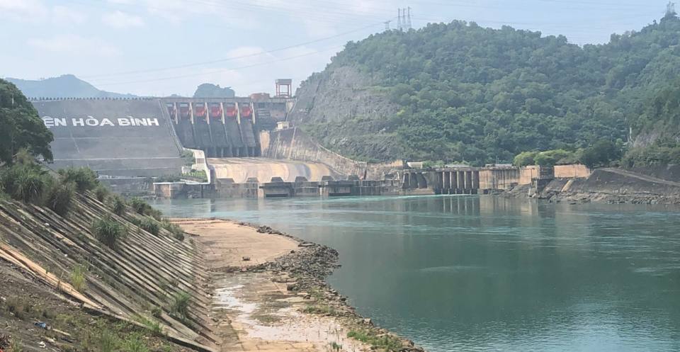

Hoa Binh Dam, Da River, Vietnam. © BGS/UKRI.
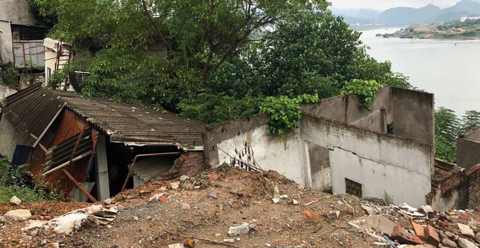
River bank and house collapse. © BGS/UKRI.
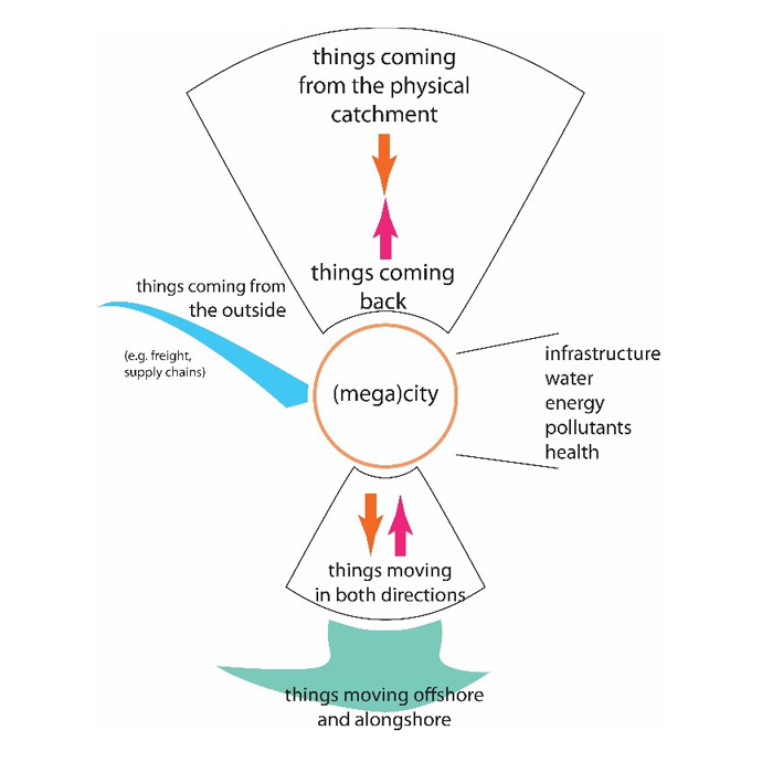
The concept of a city-catchment observatory, showing the flow of events and information. In this case, the observatory is aimed at the sustainability of the central city, which is the focus of physical, social, economic and political pressures. © BGS/UKRI.
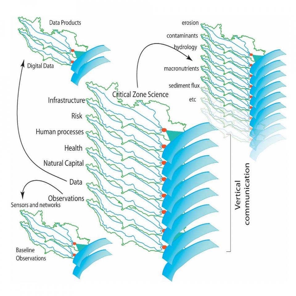
Diagram showing the ambition to develop a fully sensed catchment observatory in the Red River catchment, northern Vietnam. The different layers of the observatory correspond to different components of the system and the system goes all the way from source to sink, from mountains in the upper reaches to the shelf offshore from the delta. © BGS/UKRI.
Beyond the use and utility of the catchment as a natural organising unit, we also recognise the need to measure as many things as possible, because things are inevitably related to each other! Of course, the connections are not all of the same strength, but often we don’t know how strong and over what time scale the connection is. In principle, therefore, we have the ambition to develop a holistic catchment observatory.
The model for this is drawn in part from the Critical Zone Observatory (CZO) program begun by the US National Science Foundation (NSF) in 2007. The critical aspect of the NSF’s CZO design is that it brought together all disciplines in earth-surface process (e.g. hydrology, geohydrology, biogeochemistry and geomorphology).
We have the ambition to extend this concept further still and, at the same time, to extend the meaning of ‘catchment’. This is particularly important when the driver for an observatory is related to disaster risk reduction (writ large) in less developed countries. Thus, other components that become important are related to human elements:
- Where are people moving from when they move into a city?
- What infrastructure is being developed or exists that mitigates hazards or, conversely, exacerbates hazards?
- What policies exist that mitigate and/or exacerbate hazards?
- How do administrative boundaries that cross physical catchments cause difficulties in planning and/or responding to hazards?
The BGS is currently setting up a pilot-scale observatory to serve Hanoi, Vietnam, in the context of hazards and resilience to those hazards. Equipment for the pilot observatory was provided by the UK Natural Environment Research Council (NERC). The observatory, now called the Multi-hazard and Resilience Observatory for Hanoi (MROH), is managed jointly by the BGS and the Vietnam Institute for Geosciences and Mineral Resources (VIGMR), within the Ministry of Natural Resources and the Environment. VIGMR have dedicated lab and office space to the MROH and is coordinating with several Vietnam government agencies to deploy the initial sensors.
Contact
If you want to discover more then please contact BGS Enquiries (enquiries@bgs.ac.uk).
You may also be interested in

Urban geoscience
Providing solutions for urban land-use planning and sustainable development.
Anthropocene
The Anthropocene is a newly proposed geological time-unit, first suggested in the year 2000. It is as significant as the discovery of plate tectonics.