BGS is a world leader in visualising the subsurface, which, combined with parameterised ground models, provides a platform for characterising and quantifying the ground’s behaviour. We apply this understanding to our interactions with the subsurface to support sustainable energy, environmental and ground engineering activities. Realising the natural capital provided by the ground in these areas requires continued sampling and measurement of the subsurface and the Engineering and Geotechnical Capability was established with this in mind.
The capability provides the infrastructure underpinning field and laboratory research and development, and the long-term management of geophysical and geotechnical property data at BGS. Figure 1 shows the structure of the facility.
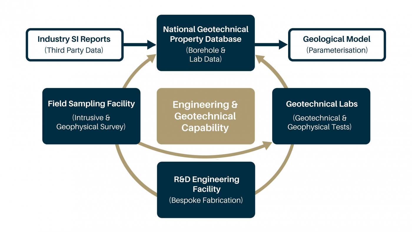

Figure 1 Engineering and Geotechnical Capability internal structure and linkages. BGS © UKRI.
Figure 1 also shows the data pathways through the capability. As well as the data generated by our research programme, we also ingest third-party data from UK site investigations. The laboratory and field data generated by our research supports the BGS’s strategic programme for multiscalar ground model visualisation and attribution.
Engineering properties and behaviour of UK rocks and soils
Understanding ground behaviour is core to understanding the performance of critical UK infrastructure and how it changes with time. Key hydrogeological, geophysical and geotechnical properties control ground behaviour in excavations, foundations, tunnels and engineered fill.
For over 20 years, our research has generated a wealth of data and information on the engineering performance of the geological formations that are strategically important to UK infrastructure and development. This research undertaking has led to the characterisation of major bedrock and superficial formations in terms of their engineering, which can be accessed via our information products, including:
- National Geotechnical Properties Database
- Formation study reports
- National engineering geology map interactive viewer
- National engineering geology map downloads
Services
We specialise in the analysis, interpretation and problem solving integral to research and development. We offer bespoke solutions to BGS core science and commissioned research programmes, providing a single facility to integrated service support.
Our services include:
- innovative research and development solutions for field and laboratory activities and apparatus
- in situ field measurement, sampling and laboratory testing of geological materials
- collation and digitisation of UK site investigation data
- maintenance of the National Geotechnical Properties Database
- data analysis to support the parameterisation of the National Geological Model
- development of geotechnical and geophysical property relationships to support and quantify geophysical monitoring activities
- geophysical monitoring activities for ground visualisation, natural and engineered asset condition and performance indices
- ground characterisation of natural and engineered ground including landslide observatories, geotechnical earthworks and seismic amplification.
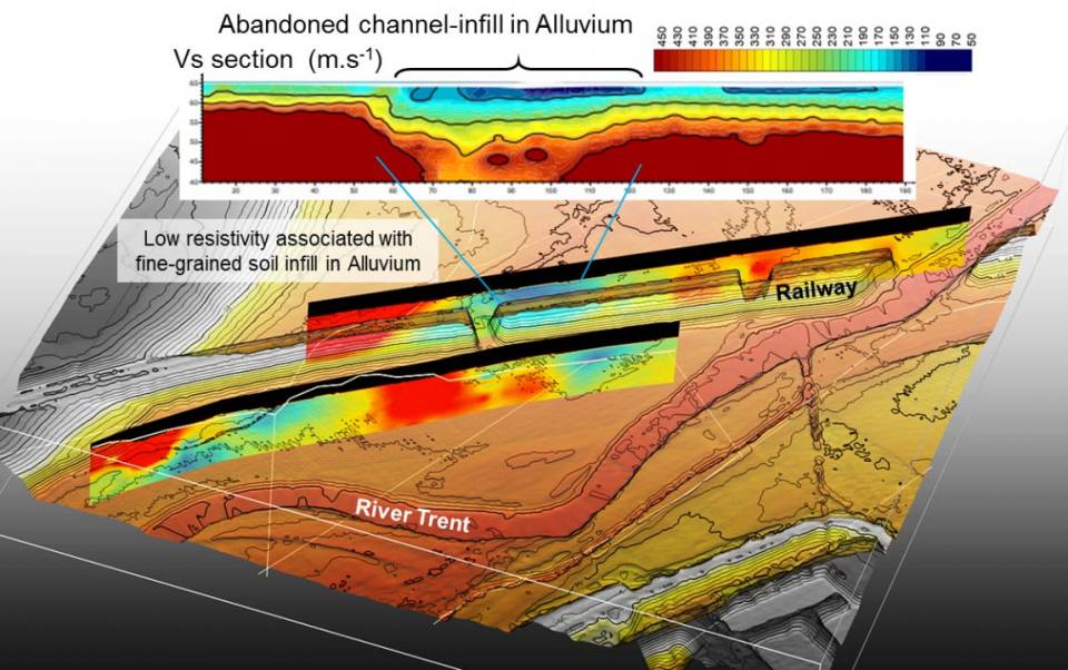 Figure 2: High-resolution ground characterisation for engineering applications. BGS © UKRI.
We don’t simply make measurements of the ground: we integrate these measurements into coherent ground models at a scale that is fit-for-purpose for a range ground engineering applications.
Figure 2 shows the application of high-resolution resistivity and non-invasive shear-wave velocity-mapping methods to image an infilled meander channel in alluvium on the River Trent floodplain.
The highlighted 2D section runs parallel to the current West Coast Rail main line and was formerly chosen as the route for the HS2 rail line. Fine soft soils infilling the meander pose potential challenges to construction due to consolidation affecting the bearing capacity and may also amplify train-induced ground vibrations. (The HS2 route has since been re-designated further to the north-west.)
Publications and case studies
This study demonstrates the use of multichannel analysis of surface waves (MASW) to measure changes in Rayleigh wave velocity relating to both the initial trench construction and subsequent simulated failures (water leaks) of a buried water pipe. The MASW field trials were undertaken in conjunction with a wider suite of geophysical monitoring techniques at a site in south-west England, within an area of clayey sandy silt.
The Rayleigh wave velocity through a soil approximately equals the shear wave velocity, which in turn is predominantly dependant on the shear modulus of the soil (G) and this can be inferred to give a measure of the relative strength of a soil. It is proposed that the time-lapse measurement of Rayleigh wave velocity may be used to monitor ongoing changes in soil strength and therefore the MASW technique could perform a significant role in monitoring the initiation or progression of any internal processes within a geotechnical asset, before they would otherwise be identified through visual inspection alone.
- Dashwood, B A J, Gunn, D A, Curioni, G, Inauen, C, Hobbs, P R N, and Reeves, H. 2019. Surface wave surveys for imaging ground property changes due to a leaking water pipe. Journal of Applied Geophysica, Vol. 174, 103923. DOI: https://doi.org/10.1016/j.jappgeo.2019.103923
At present, British (BS 1377, BSI, 1990) and American (D427-04; T92-97) standards describe soil shrinkage measurements via displacements of liquid mercury in which the sample is immersed. Both methods present a significant health hazard related to the spread of the mercury vapours, leading to a ban on its use in many soils laboratories. The BGS system, called SHRINKiT, employs laser scanning, combining successive high-resolution volume and mass measurements to determine soil shrinkage limit.
- Hobbs, P R N, Jones, L D, Kirkham, M P, Gunn, D A, and Entwisle, D C. 2019. Shrinkage limit test results and interpretation for clay soils. Quarterly Journal of Engineering Geology and Hydrogeology, Vol. 52(2), 220–229. DOI: http://dx.doi.org/10.1144/qjegh2018-100
- Hobbs, P R N, Jones, L D, Kirkham, M P, Roberts, P, Haslam, E P, and Gunn, D A. 2014. A new apparatus for determining the shrinkage limit of clay soils. Géotechnique, Vol. 64(3), 195–203. DOI: http://dx.doi.org/10.1680/geot.13.P.076
- Jones, L D, and Hobbs, P R N. 2004. The shrinkage and swelling behaviour of UK soils: the clays of the Lambeth Group. British Geological Survey Research Report RR/04/001. (Nottingham, UK: British Geological Survey.)
Surface-wave surveying is a field geophysical technique used to assess the small-strain stiffness characteristics of railway subgrade and geotechnical assets.
The surveys captured complex structures consistent with end tipping within an aged Victorian embankment. Anatomical imaging of the asset was possible, enabling location of the stiffness contrasts between different fill materials needed to understand dynamic load performance and early identification of progressive subgrade deterioration that precedes track geometry problems.
- Bergamo, P, Dashwood, B, Uhlemann, S, Swift, R, Chambers, J, Gunn, D A, and Donohue, S. 2016. Time-lapse monitoring of climate effects on earthworks using surface waves. Geophysics, Vol. 81(2), 1MA–Z17. DOI: https://doi.org/10.1190/geo2015-0275.1
- Bergamo, P, Dashwood, B, Uhlemann, S, Swift, R, Chambers, J, Gunn, D A, and Donohue, S. 2016. Time-lapse monitoring of fluid-induced geophysical property variations within an unstable earthwork using P-wave refraction. Geophysics, Vol. 81(4), 1JA–Z38. DOI: https://doi.org/10.1190/geo2015-0276.1
- Gunn, D A, Chambers, J E, Dashwood, B, Dijkstra, T, Lacinska, A, Milodowski, A, Wragg, J, Uhlemann, S, Swift, R, Kirkham, M, and Donohue, S. 2018. Deterioration model and condition monitoring of aged railway embankment using non-invasive geophysics. Construction and Building Materials, Vol. 170, 668-678. DOI: https://doi.org/10.1016/j.conbuildmat.2018.03.066
- Gunn, D, Dashwood, B A J, Bergamo, P, and Donohue, S. 2016. Aged embankment imaging and assessment using surface waves. Proceedings of the Institution of Civil Engineers — Forensic Engineering, Vol. 169(4), 149–165. DOI: http://dx.doi.org/10.1680/jfoen.16.00022
- Hen-Jones, R, Hughes, P, Stirling, R, Glendinning, S, Gunn, D, Chambers, J, and Cui, Y. 2017. Seasonal effects on geophysical-geotechnical relationships and their implications for electrical resistivity tomography monitoring of slopes. Acta Geotechnica, Vol. 12(5), 1159-1173. DOI: https://doi.org/10.1007/s11440-017-0523-7
This paper discusses the development and application of geophysical techniques from a historical UK perspective. Covering the last 50 years, this study begins in the 1960s with geophysical exploration in former African dependencies. We also show how the development of seismic surveying for hydrocarbons through the 70s and 80s is linked to our post-war motorway expansion and how the regeneration of our urban centres through the 90s and 00s provided the catalyst for geophysical methods to help characterise disturbed and contaminated ground. We take a final look at the issue of swelling urban populations and the need for very high-resolution methods to aid detection and laying of utility infrastructure within a congested cityscape.
- Gunn, D.A. (2017). The geophysics contributions from the QJEGH, 1967 – 2015. Quarterly Journal of Engineering Geology and Hydrogeology, Vol. 50, 379–392. DOI: https://doi.org/10.1144/qjegh2017-002
Fossil fuel and renewable energy supplies rely upon offshore platforms constructed in the shallow seas around the UK. Injected concrete grout joins the steel substructures used in the foundations supporting these platforms on the sea bed. The foundation substructure joint comprises concrete-grout sandwiched between two steel plates. The condition of the grout deteriorates with time and can develop cracks at its interfaces with either steel substructure.
This case study describes the development of an underwater inspection system that uses ultrasound beamed onto the outer faces of the steel plates to inspect the condition of the internal grout joint.
- Offshore infrastructure foundation inspection methods
- Brett, C R, Gunn, D A, Dashwood, B A J, Holyoake, S J, and Wilkinson, P B. 2018. Development of a technique for inspecting the foundations of offshore wind turbines. Insight – Non-Destructive Testing and Condition Monitoring, Vol. 60(1), 19–27. DOI: http://dx.doi.org/10.1784/insi.2018.60.1.19
- Gunn, D A, Holyoake, S J, Dashwood, B A J, Wilkinson, P B, Brett, C R, Wallis, H C, Leman, W, and Rees, J G. 2019. Ultrasonic testing of laboratory samples representing monopile wind turbine foundations. Insight – Non-Destructive Testing and Condition Monitoring, 61(4), 187–196. DOI: http://dx.doi.org/10.1784/insi.2019.61.4.187
- Wilkinson, P B, Gunn, D A, Holyoake, S, Dashwood, B A J, Brett, C R, and Rees, J G. 2018. Low frequency acoustic and ultrasound waves to characterise layered media. NDT & E International, Vol. 96, 35–46. DOI: https://doi.org/10.1016/j.ndteint.2018.03.005
- Chambers, J E, Gunn, D A, Wilkinson, P B, Meldrum, P I, Haslam, E, Holyoake, S, Kirkham, M, Kuras, O, Merritt, A, and Wragg, J. 2014. 4D electrical resistivity tomography monitoring of soil moisture dynamics in an operational railway embankment. Near Surface Geophysics, Vol. 12(1), 61–72. DOI: http://dx.doi.org/10.3997/1873-0604.2013002
- Haslam, E P, Gunn, D A, Jackson, P D, Lovell, M A, Aydin, A, Prance, R J, and Watson, P. 2014. Novel laboratory methods for determining the fine scale electrical resistivity structure of core. Journal of Applied Geophysics, Vol. 111, 384–392. DOI: https://doi.org/10.1016/j.jappgeo.2014.07.017
Find out more about our research
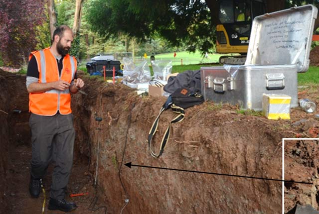
Field Sampling Facility
Undisturbed sampling offers the potential for geological characterisation critical for understanding engineering performance and ground behaviour.
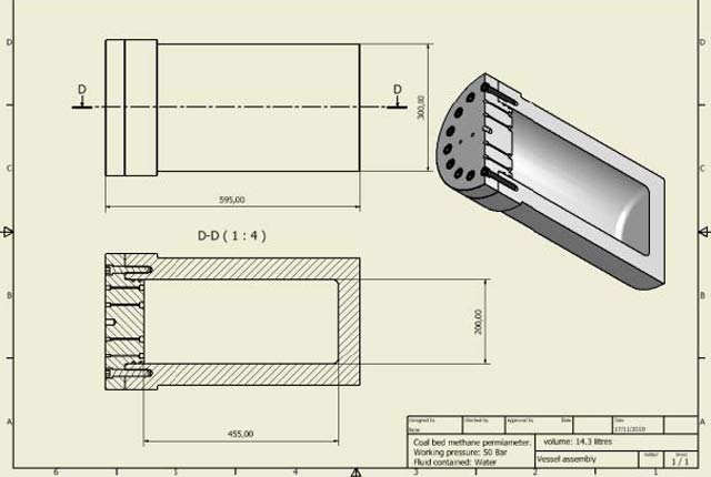
Research and Design Engineering Facility
The R&D Engineering Facility conceptualises, designs, tests and manufactures unique and novel equipment for BGS research.
Rock Mechanics and Physics Laboratory
The Rock Mechanics and Physics Laboratory researches the properties and behaviour of rocks and geomaterials at near-surface to shallow crustal depth.
Geo-laboratories
Wet and dry sample storage, preparation and standard and non-standard geotechnical and geophysical property testing.
National Geotechnical Properties Database
This is a relational database enabling interrogation of AGS 4.0 formatted geoenvironmental and geotechnical data critical to UK engineering.
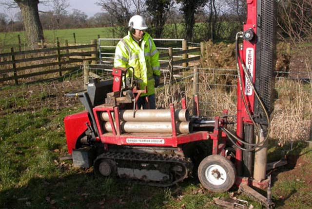
Dando Drilling Capability
The BGS Drilling Facility performs shallow drilling operations and tests to support BGS research.