Sea floor: scientific ocean drilling
BGS Research
BGS provides operations and science management for major scientific ocean-drilling projects. Since 2003, we have implemented several high-profile expeditions for the European Consortium for Ocean Research Drilling (ECORD), under the auspices of the International Ocean Discovery Program (IODP). We work closely with our partners within the ECORD Science Operator (ESO), a consortium comprising:
- BGS
- University of Bremen: Center for Marine Environmental Sciences (MARUM)
- University of Leicester: geophysics and borehole research group
- University of Montpellier: transfers in porous media team
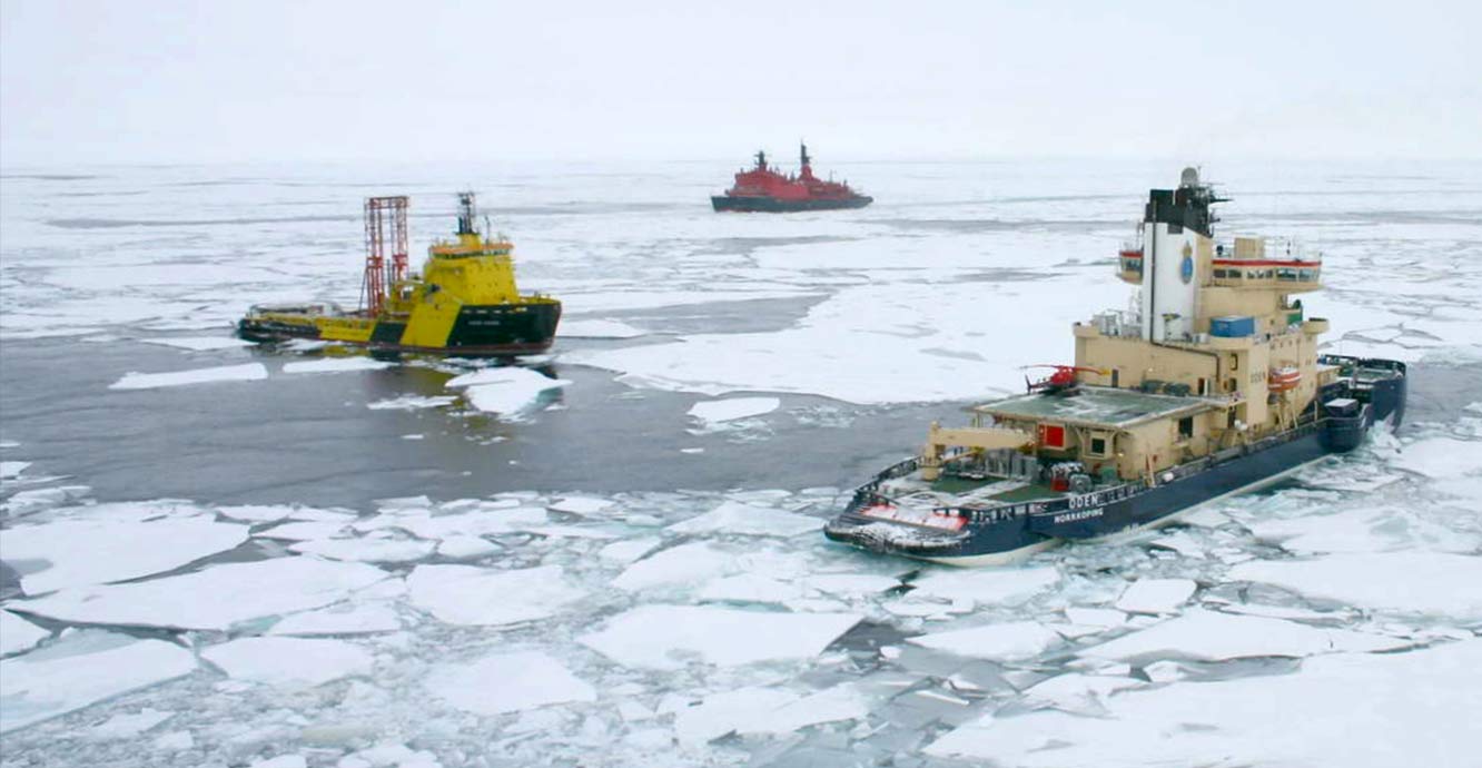

IODP Expedition 302: Arctic coring expedition, 2004. The drillship Vidar Viking (yellow) remains in position for coring and logging, while the Oden (blue) and Sovetskiy Soyuz (red) defend the drillship from moving ice, 2004. © Arno Keinonen.
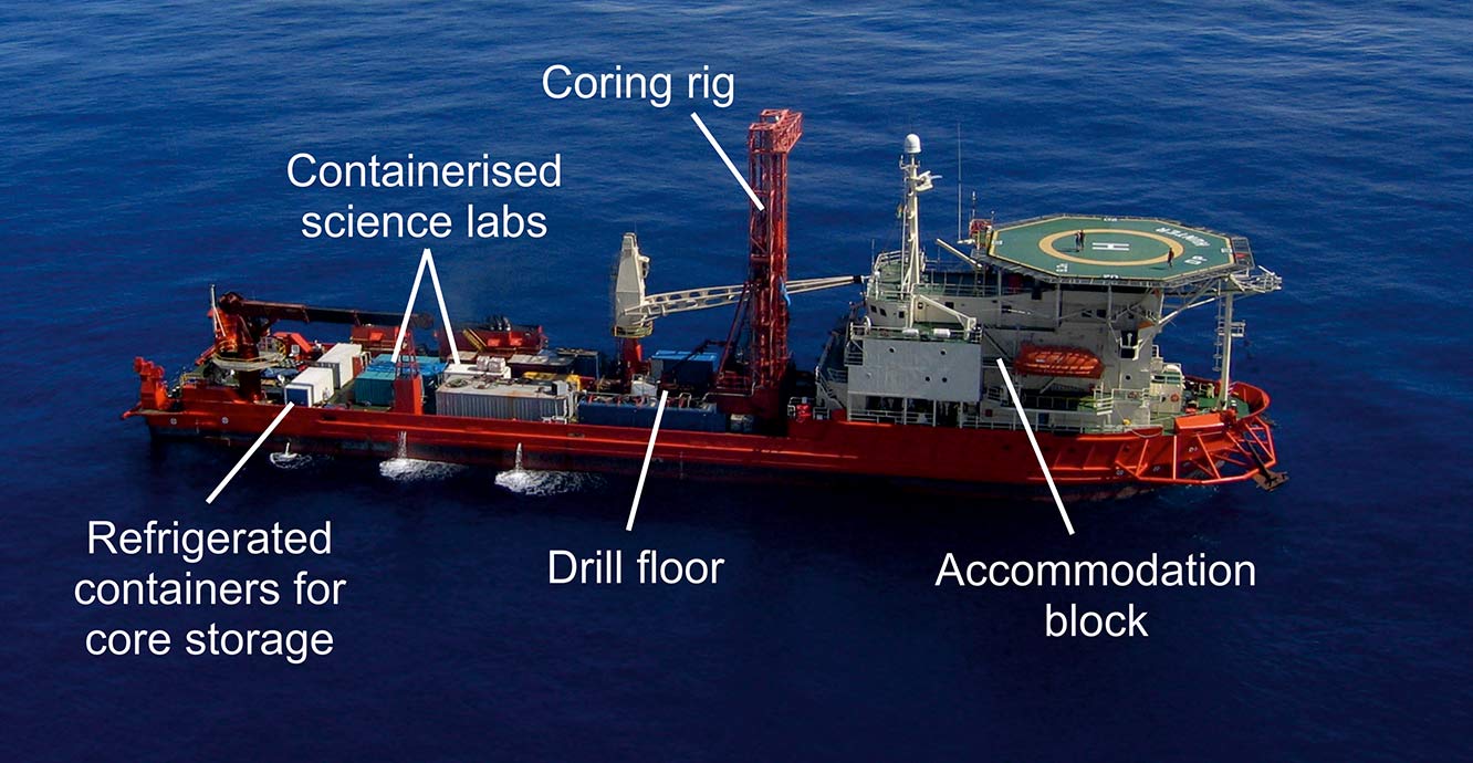
The drillship DP Hunter during IODP Expedition 310: Tahiti sea level, 2005–2006. The DP Hunter cored the shallow reefs around Tahiti to gather new data on the paleoceanographic evolution of the tropics as recorded in coral reefs located in tectonically inactive areas. BGS conducted a sister expedition in 2010 on the Great Barrier Reef (IODP Expedition 325). © ECORD/IODP.
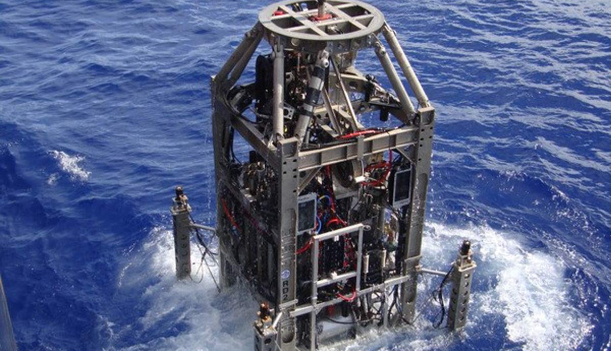
Launching of the BGS Rockdrill 2 (RD2) during IODP Expedition 357: Atlantis Massif serpentinisation and life, 2015. This was the first IODP expedition to deploy sea-floor drill technology. Two drills were deployed at various times during the expedition, the BGS RD2 and the MARUM MeBo70. © David Smith, ECORD/IODP.
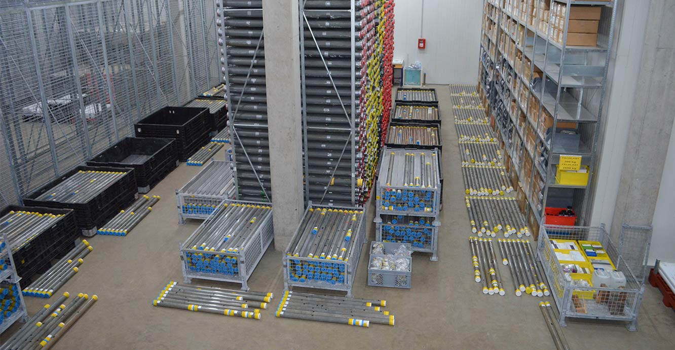
Expedition cores laid out in the IODP Bremen Core Repository, MARUM, University of Bremen, during IODP Expedition 381: Corinth active rift development, 2017–2018. The cores were readied to be processed, analysed and sampled in the nearby laboratories by the international science party. © ECORD/IODP.
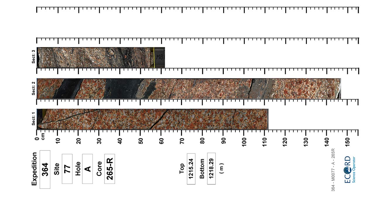
Images of the split surface of a core collected at about 1215 m below sea floor from IODP Expedition 364: Chicxulub impact crater, 2016. The cores are made of granite, which has been severely damaged by the shockwave generated by an asteroid impact 66 million years ago at the end of the Cretaceous Period (now linked to the demise of the dinosaurs). The impact moved these rocks 20 to 30 km in about 10 minutes before emplacement in their current location.
Image from IODP Expedition 364 Scientists (2017): Core overview images of IODP Hole 364-M0077A.
As part of the ESO partnership, we support the global geoscientific community in their efforts to address the challenges outlined in the IODP Science Plan:
- climate and ocean change
- biosphere frontiers
- Earth connections
- Earth in motion
We coordinate the ESO partnership. We design, build and manage offshore scientific drilling operations and provide coring expertise and operational oversight. Additionally, we provide procurement services, coordinate permitting and expedition scoping efforts, manage the science party and science outputs, and manage expedition outreach activities. Our consortium partners provide expertise, facilities and services for the curation, databasing, archiving and analysis of collected cores and samples, the acquisition of IODP standard measurements, and downhole logging services.
With our partners, we have implemented a series of eight ‘mission-specific platform’ IODP expeditions using a diverse range of vessels, including geotechnical vessels and self-raising lift boats with temporary drill rigs, multipurpose drilling vessels, and research ships equipped with robotic sea-floor drill rigs provided by BGS and MARUM.
We have carried out scientific drilling from the ice fields of the central Arctic Ocean to the barrier reefs of the South Pacific, drilling in water depths of less than 20 m to over 1.5 km. We have recovered over 6.6 km of core material from diverse lithologies including fossil corals that reveal the paleoceanographic evolution of the tropics; highly deformed, biosphere-hosting altered ultramafics from the central Atlantic Ocean, and a near-continuous lithological record from the Chicxulub impact crater in the Gulf of Mexico.
The cores and data that we gather are analysed by the expedition science parties, and later by the wider IODP community, to meet a wide range of scientific objectives.
The IODP expeditions implemented by BGS and partners within ESO are:
- Expedition 302: Arctic coring expedition, 2004
- Expedition 310: Tahiti sea level, 2005–2006
- Expedition 313: New Jersey shallow shelf, 2009
- Expedition 325: Great Barrier Reef environmental changes, 2010
- Expedition 347: Baltic Sea paleoenvironment, 2013–2014
- Expedition 357: Atlantis Massif, 2015–2016
- Expedition 364: Chicxulub impact crater, 2016
- Expedition 381: Corinth active rift development, 2017–2018
Related news

Geological research in North Sea helping to safeguard subsea cables
06/07/2026
Subsea power and telecommunications cables are critical to the UK’s energy infrastructure and global connectivity, yet they remain vulnerable to damage from ship anchors, fishing activity and natural hazards.

UK scientists unite for seabed mapping survey of the UK’s south-west coastline
15/04/2026
BGS geologists join research voyage, gathering crucial geological data to support offshore energy and infrastructure projects.

Updated geological assessment of the Southern North Sea set to underpin future offshore infrastructure development
25/03/2026
The first regional assessment for 30 years will support offshore marine and subsurface planning for the UK’s low-carbon energy infrastructure, including the 2030 target of 45 to 50 GW generated through offshore wind.

Extensive freshened water confirmed beneath the ocean floor off the coast of New England for the first time
09/02/2026
BGS is part of the international team that has discovered the first detailed evidence of long-suspected, hidden, freshwater aquifers.

Quaternary UK offshore data digitised for the first time
21/01/2026
The offshore wind industry will be boosted by the digitisation of a dataset showing the Quaternary geology at the seabed and the UK’s shallow subsurface.

Offshore Quaternary 250K
The 1:250 000-scale offshore geological map for quaternary geology (BGS Geology: marine quaternary 250k) is available digitally.

How the geology on our doorstep can help inform offshore infrastructure design
19/11/2025
BGS is part of a new collaboration using onshore field work to contextualise offshore data and update baseline geological models which can inform the sustainable use of marine resources.

Extended seabed geology map of the Bristol Channel published
07/10/2025
BGS has released significantly extended high-resolution maps that will support offshore green-energy initiatives in the area.

New seabed sediment maps reveal what lies beneath the waves
03/09/2025
Marine ecosystem science and offshore infrastructure will be boosted by a new dataset showing sediment composition across the UK continental shelf.

Seabed sediments 250K
This offshore Quaternary geology dataset shows the distribution of interpreted lithostratigraphical units within the shallow subsurface. The dataset represents the Quaternary geology immediately beneath the active seabed sediment layer.

Offshore bedrock 250K
The BGS Offshore Bedrock 250k dataset depicts the distribution of the different types of bedrock on the UK Continental Shelf.

IODP³-NSF Expedition 501: successful offshore operations launches onshore phase
06/08/2025
Scientists have managed to take water and sediment samples from beneath the ocean on the New England Shelf for the first time, with the intention of understanding this offshore aquifer system.
Sea floor: marine geoscience
Providing independent and expert geological advice, research and data acquisition to anyone working in the marine environment.
Coasts and estuaries geohazards
Providing independent and expert geoscientific tools and advice to assess different adaptation options to coastal flooding and erosion.