BGS awarded research grant to support potential offshore wind development in Iceland
BGS has been awarded the NERC-Arctic grant for a collaboration project with Iceland GeoSurvey.
13/05/2024 By BGS Press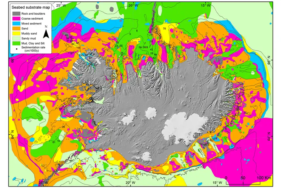

BGS and Iceland GeoSurvey (ÍSOR) will collaborate and share their knowledge on windfarm development to help drive the opportunity for offshore Icelandic renewable energy.
As part of the one-year project, there will be two field trips, one to Iceland in August 2024 and another to Scotland in September 2024. These trips will combine fieldwork and workshops focused on knowledge exchange, particularly on the process of geological ground-model development. They will highlight how geologists characterise the geology and outline potential geological constraints at the seabed, near the seabed surface, and in changing coastal domains.
As part of the Icelandic fieldwork, the BGS-ÍSOR partnership will be heading to Skeiðarársandur, the largest glacial outwash plain in the world. This site is an analogue for subsurface conditions expected in buried palaeo-landscapes found in the North Sea. Both countries have rugged coastlines with varying bedrock characteristics. Additionally, Iceland must account for geodynamic shifts due to tectonic plate movements and volcanic eruptions.
Upon project completion, the partnership will gain a deeper understanding of glacial systems, focusing on the range and distribution of sediments and bedrock properties resulting from the diverse coastal formations off the coast of Iceland compared to the UK. This insight will enable project partners to make more informed assessments regarding foundation designs for renewable energy infrastructure.

The NERC-Arctic grant and cooperation with the British Geological Survey is an exciting opportunity for Iceland to chart and access a completely new area of the renewable industry, as Iceland’s focus has been traditionally onshore in geothermal and hydropower production. This collaboration is the beginning of a better understanding of the opportunities and de-risking processes for offshore renewables in extreme environments for Iceland.
Anett Blischke, marine geoscientist at ÍSOR and the University of Iceland.
BGS and ÍSOR are part of the Geological Service for Europe (GSEU), aiming to create partnerships and knowledge exchange between countries on optimising offshore windfarm siting. The NERC-Arctic grant is an exciting example of gaining insights into subsurface variability through applied fieldwork, leading to further understanding on the potential impact on foundation design for offshore renewables in different geological settings.
Nicola Dakin, BGS Marine Geoscientist.
The Iceland Arctic Science Partnership scheme is an opportunity for researchers based in the United Kingdom and Iceland to make joint applications for bursaries ranging from £5000 to a maximum of £20 000 to support active participation in new partnerships.
Erlendsson, Ö, Blischke, A, Hjartarson, Á, Óðinsson, D Þ, and Vésteinsson, Á Þ. 2023. The Geological mapping of Iceland’s Insular Shelf and Adjacent Deep Ocean. EGU General Assembly 2023, EGU23-15536.
Erlendsson, Ö, Hjartarson, Á, Helgadóttir, G, Jónasson, J P, Ólafsdóttir, S H, and Burgos, J M. 2015. Botngerð og laus jarðlög á landgrunni Íslands. Abstract, Haustráðstefna Jarðfræðifélags Íslands 2015.
Thors, K. 1978. The seabed of the southern part of Faxaflói, Iceland. (Botngerð í sunnanverðum Faxaflóa). Jökull, 28, 42–52.
Relative topics
Related news

Building Europe’s geological future
20/07/2026
BGS scientists are contributing to a continent-wide initiative that is strengthening collaboration across borders to tackle shared subsurface challenges and unlock new opportunities.

Delving deep into mountains for future water security
16/07/2026
A BGS-led project is using new water-tracing investigation methods, geophysics and modelling to understand how water moves from mountains to the lowlands, helping to improve water security for billions of people.

Cheshire Geoenergy Observatory releases key geological datasets for UK thermal energy storage scheme design
09/07/2026
A new report and data packs from BGS will provide a unique resource for scientists working on the geology and hydrogeology of the Sherwood Sandstone Formation, an important aquifer and reservoir rock.

Geological research in North Sea helping to safeguard subsea cables
06/07/2026
Subsea power and telecommunications cables are critical to the UK’s energy infrastructure and global connectivity, yet they remain vulnerable to damage from ship anchors, fishing activity and natural hazards.

UK and Philippines scientists investigate natural hydrogen generation processes at atomic scale
22/06/2026
BGS researchers were granted access to use the Diamond Light Source facility in order to study hydrogen in light brighter than the sun.

Shortage of end-of-life materials presents challenge to UK critical minerals security
17/06/2026
A new report by the UK Critical Minerals Intelligence Centre reveals insufficient end-of-life material stocks present a supply risk over the coming decade, but offer significant long-term potential to meet critical mineral demand through recycling.

UK geothermal catalogue receives update
16/06/2026
BGS releases the second digital version of the UK geothermal catalogue of subsurface temperature and rock thermal conductivity measurements and heat flow calculations.

Ukraine and the UK strengthen their commitment to geological cooperation
10/06/2026
A new Memorandum of Understanding reaffirms the UK’s support of Ukraine’s ambitions to develop its critical mineral resources, paving the way for collaboration through capacity-building programmes.

International science consortium to survey the health, economic value and social importance of Lake Victoria
22/05/2026
The project will replicate the 1927 survey to assess changes in the lake’s health, economic value and social importance.

BGS contributes to UN sand and sustainability report
19/05/2026
The new report highlights the impact of poor governance and unsustainable sand mining practices, calling on policymakers to take action.
Natural hydrogen research
Understanding aspects of the natural hydrogen value chain on a national and international level.
BGS engineering geologist elected to CCOP
29/04/2026
Marcus Dobbs has been elected as vice-chair of the advisory group for the Coordinating Committee for Geoscience Programmes in East and Southeast Asia.