The BGS geological timechart provides colourful reference material for use in schools, colleges and at home, setting out the geological timescale and geochronological terms we use at BGS. You can browse the timechart by geological era in the page below or download the Phanerozoic Timechart as a pdf.

The BGS geological timechart is based on The Geologic Time Scale 2012. BGS © UKRI.
Cenozoic Era
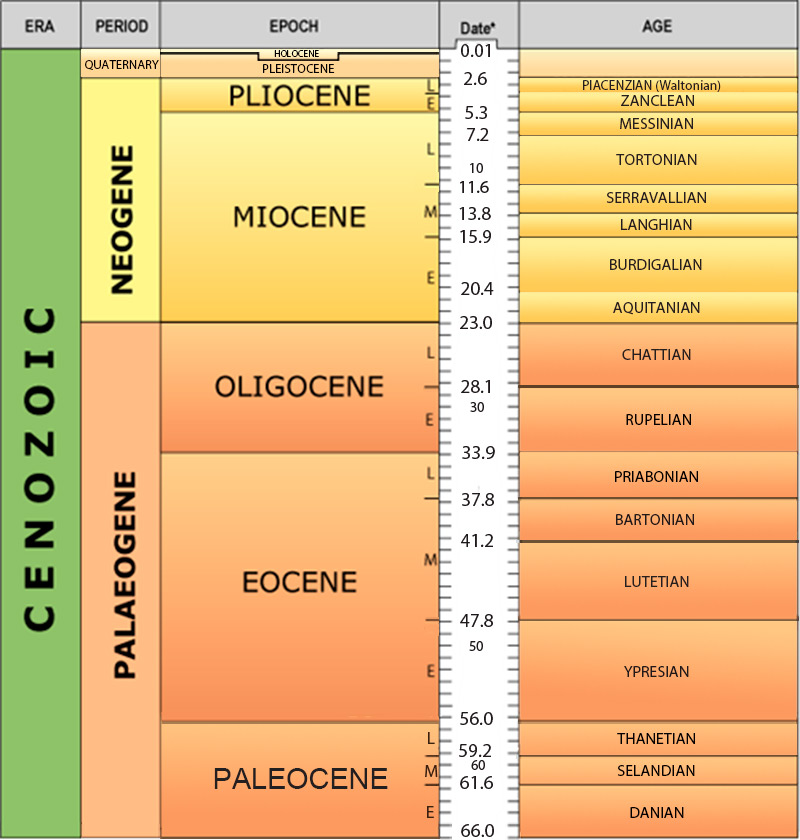
Palaeogene and Neogene timechart. BGS © UKRI.
In the Palaeogene Period, Britain had a very warm climate, but it gradually cooled as Britain drifted northwards. By the Quaternary, glaciers covered the middle and north of Britain, shaping the landscape we see today. The first humans occupied Britain during the Quaternary.
Mid to late Mesozoic Era
Cretaceous
In the Early Cretaceous, Britain experienced a warm climate with lagoonal, lake and fluvial environments. Rocks of this age contain dinosaur remains. Higher sea levels led to chalk deposition in the Late Cretaceous. Many groups of animals became extinct at the end of the Cretaceous, including ammonites and dinosaurs.
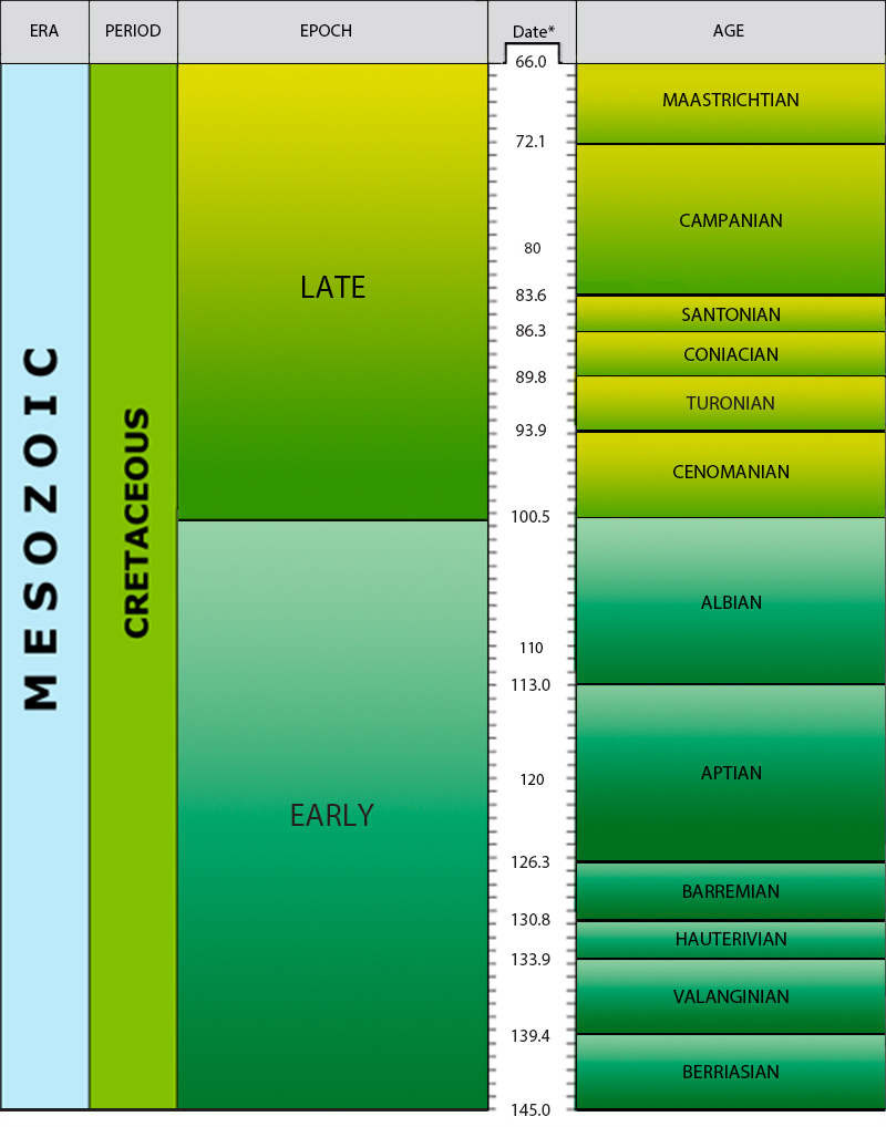
Cretaceous timechart. BGS © UKRI.
Jurassic
In the Jurassic Period, parts of Britain were covered by shallow tropical seas in which mudstones, limestones and sandstones were deposited. The abundant life in the Jurassic included ammonites and dinosaurs.
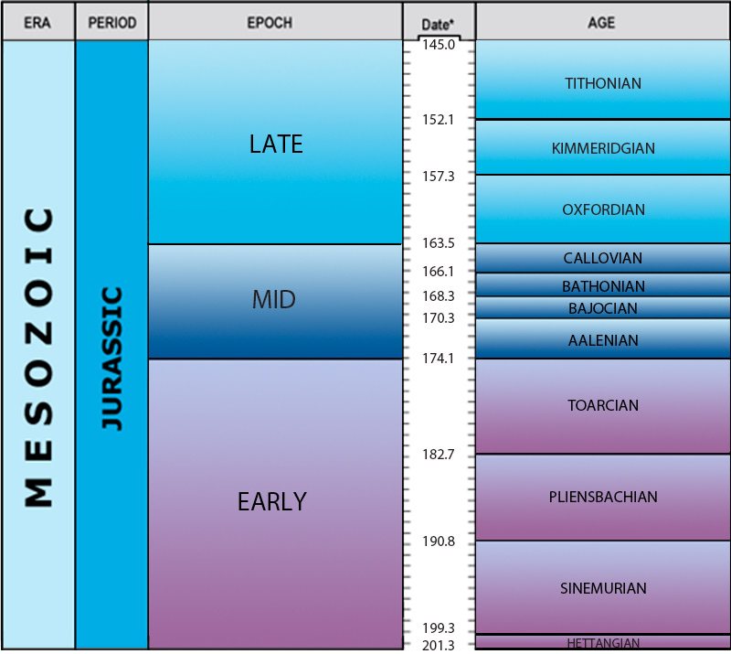
Jurassic timechart. BGS © UKRI.
Late Palaeozoic to early Mesozoic eras
Triassic
During the Triassic Period, a hot and dry environment led to the deposition of sandstones, salts and mudstones in deserts, rivers and shallow lakes. Reptiles were common and the first dinosaurs evolved.
Permian
During the Permian Period, Britain lay on the supercontinent of Pangaea and experienced hot, dry conditions. Sandstones formed from desert sand dunes. Limestones and salts were deposited in a nearby inland sea (the Zechstein Sea). Many groups of animals became extinct at the end of the Permian.
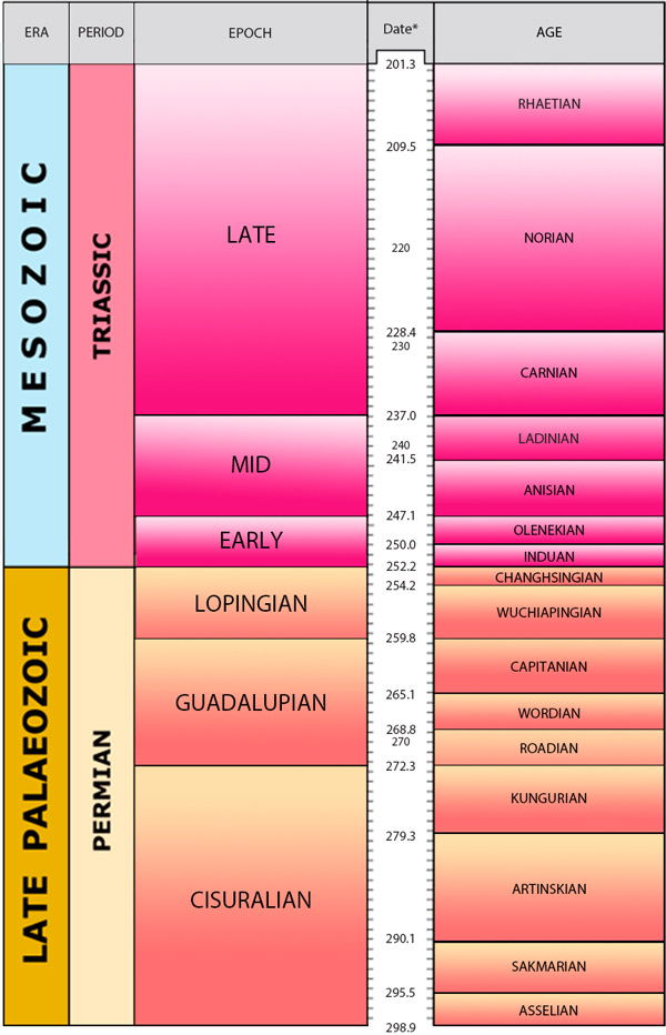
Permian and Triassic periods. BGS © UKRI.
Carboniferous
In the early Carboniferous Period, Britain lay near the equator. Limestones containing corals, brachiopods and trilobites were deposited in shallow seas. Later, sandstones, mudstones and coals were deposited in coastal swamps dominated by forests of giant ferns and horsetails.
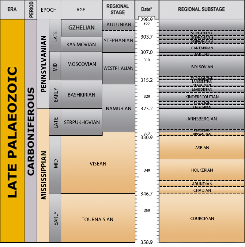
Carboniferous Period. BGS © UKRI.
Devonian
In the Devonian Period, Britain lay south of the equator and had a semi-arid climate. Marine limestones, sandstone and mudstones were developed in the south-west. Elsewhere sandstones were deposited by rivers on the coastal plain (sometimes known as the ‘Old Red Sandstone’). Fossils include fish and the first higher plants.
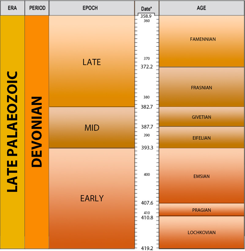
Devonian timechart. BGS © UKRI.
Early Palaeozoic Era
Silurian
In the Silurian Period, Britain lay south of the equator with a tropical to subtropical climate. A sea covered Britain that was shallower in the south (limestones) and deeper in the north (sandstones and mudstones). Silurian fossils include corals, brachiopods, trilobites and graptolites.
Ordovician
In the Ordovician Period, Britain lay south of the equator and had a cool climate. Seas covered Britain and there was dramatic volcanic activity as the ocean separating England and Wales from Scotland started to close.
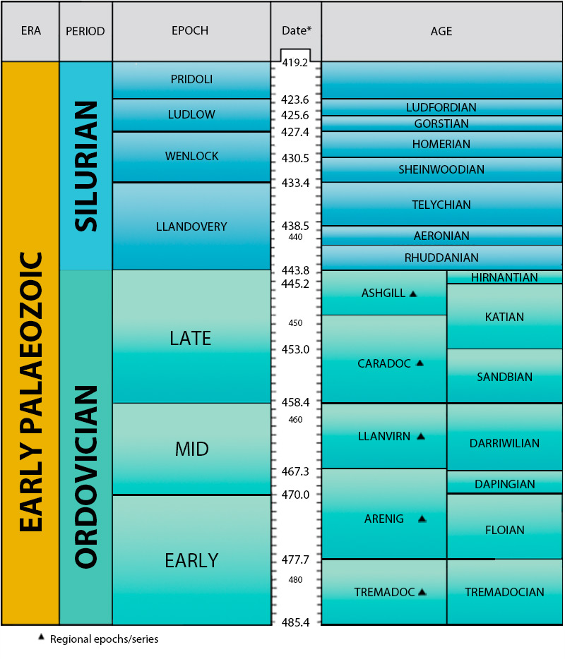
Silurian and Ordovician timechart. BGS © UKRI.
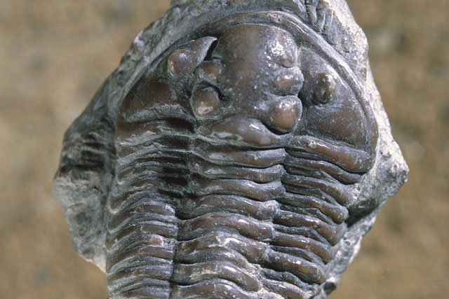
Cambrian
In the Cambrian Period, England and Wales lay near the south pole and experienced a cold climate. They were separate from Scotland, which was joined to North America. A shallow sea covered much of the area and animals such as trilobites, graptolites and molluscs first appeared.
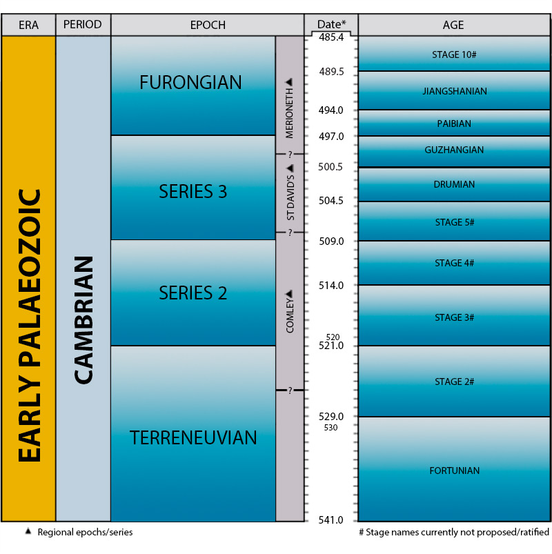
Cambrian timechart. BGS © UKRI.
Precambrian
The Precambrian is the name given to the span of time prior to the Cambrian. The Precambrian period accounts for 88 per cent of geological time.
There are very varied deposits from the Neoproterozoic, including volcanic sequences, sedimentary rocks formed in environments from deep water to terrestrial, plutonic igneous rocks and metamorphic rocks. Multicellular life developed and diversified rapidly.
In the Mesoproterozoic Era, England and Scotland lay on different continents. Mudstones, sandstones and volcanic sediments were deposited in shallow seas. Multicellular life developed.
The Palaeoproterozoic and Archaean cover a very long period of geological time during which the Earth’s crust and atmosphere were developing. The only life on Earth was single celled.
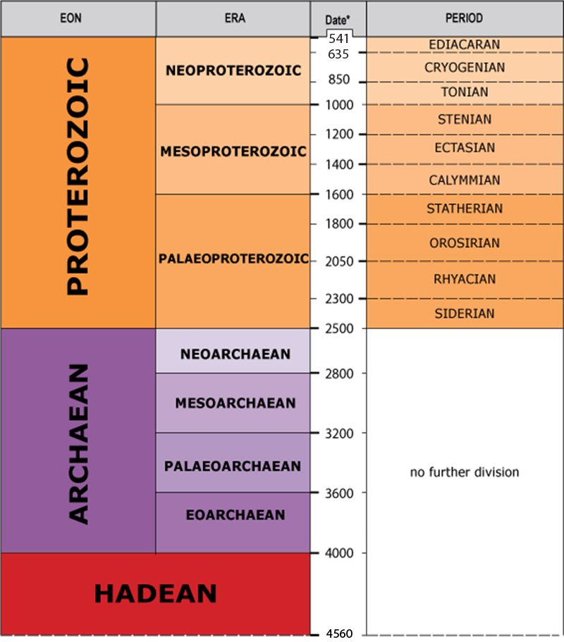
Precambrian timechart. BGS © UKRI.
Background information
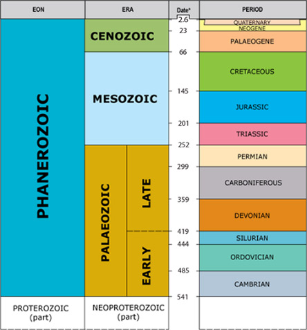
The principal chart shows the Phanerozoic (Cambrian to Quaternary) timescale. The names of the individual periods are links: each one leads to a more detailed chart showing the epochs and ages for that period.
The charts for the individual periods are all drawn to the same scale. Where there is insufficient or contradictory data on the dating of age boundaries, the ages are given an average duration within the limits of the appropriate epoch boundaries.
These age boundaries appear as dashed lines on the charts. Generally there is one period per chart except for the Palaeogene/Neogene/Quaternary, Permian/Triassic and Ordovician/Silurian.
A chart for the Archaean and Proterozoic (Precambrian) is also included.
More detailed stratigraphical information is contained in the Stratigraphical Framework Committee reports.
The BGS Geological Timechart is based on geochronology. This is the branch of earth sciences that deals with the concept of geological time and dating the sequence of events throughout the Earth’s history. Intervals of geological time are given formal names and grouped into a hierarchy according to their length (in decreasing time intervals):
- eon
- era
- period
- epoch
- age
- chron
Subdivisions are termed ‘early’, ‘mid’ or ‘late’.
Chronostratigraphy is similar, but is concerned with the relationships between time and the rocks deposited within those time intervals. Chronostratigraphical terms are applied to rocks deposited during specific intervals of time. In order of decreasing time, their hierarchical grouping is:
- eonothem
- erathem
- system
- series
- stage
- chronozone
Subdivisions are ‘lower’, ‘middle’ and ‘upper’.
Although the age of rocks can sometimes be determined directly, by radiometric dating, in most instances rocks are dated indirectly, often by means of their fossil content.
Historically, named divisions of geological time and their associated chronostratigraphical divisions have been developed independently in different parts of the world. A major task for the world stratigraphical community has been to establish a single, universal scheme for the subdivision of geological time. There is agreement at the levels of eon, era and (for the most part) period, but regional terms continue to be widely used at the lower hierarchical levels. This is because in the geological past, just like today, different environments existed on different parts of the Earth’s surface. Thus at any one time, deposits of different type and different fossil content were being deposited in different regions of the globe.
For parts of the geological column, correlation between these different regions is sufficiently well understood for the establishment of universal subdivisions at the epoch/series and age/stage levels. For some intervals and some regions, however, global correlations are poorly understood and the rocks are assigned to divisions of regional application. For example in the UK and Ireland (and, in most cases, also in north-west Europe) regional divisions are used for Cambrian series, Ordovician stages and Carboniferous epochs and stages.
A particular problem exists in relation to chronological subdivision around the Jurassic/Cretaceous boundary, where no fewer than three schemes are currently applied in different parts of the UK and Ireland. For this reason, some terms used by the BGS differ from Gradstein and Ogg (1996) in a few parts of the column.
On the BGS Geological Timechart, epoch boundaries (era boundaries in the Precambrian) have been assigned radiometric ages taken from the component timescales. Neither the dates nor even the boundaries themselves are fixed, however. Improved radiometric dating of strata is continually taking place and sometimes leads to improved age assignments for individual chronostratigraphical boundaries. Eventually, these piecemeal changes are incorporated into a revision of a complete geological timescale, such as used in this chart.
The precise definition of a chronostratigraphical boundary may also be changed by international agreement, in which case it may lie at a level younger or older than that previously established. For example, the base of the Quaternary Period has been traditionally placed in north-west Europe at a level dated at around 2.3 million years before present (2.3 Ma), whereas a recently agreed international definition places the boundary at 1.8 Ma. Similarly, some stratigraphers place the base of the Cretaceous Period at the base of the Berriasian Stage (144 Ma), whereas others place it at the base of the Ryazanian Stage, at 142 Ma. Pending international agreement on the boundary, we here we follow Gradstein and Ogg (1996) in placing it at the base of the Ryazanian Stage.
Note
Several geological timescales exist, reflecting the use of differing datasets and methods of interpretation. The BGS Geological Timechart is based on The Geologic Time Scale 2012 (Gradstein et el., 2012), with additions. The result is a composite geological timechart that will be updated as improved timescales become available.
Additional references
Cowie, J W, and Bassett, M G. 1989. International Union of Geological Sciences 1989 Global Stratigraphic Chart with geochronometric and magnetostratigraphic calibration. Supplement to Episodes, Vol. 12, No. 2.
Fortey, R A, Harper, D A T, Ingham, J K, Owen, A W, and Rushton, A W A. 1995. A revision of Ordovician series and stages from the historical type area. Geological Magazine, Vol. 132, 15–30.
Gradstein, F M, and Ogg, J. 1996. A Phanerozoic time scale. Episodes, Vol. 19, 3–5.
You may also be interested in:
Fossils and geological time
Take a look at the history of the Earth, from its formation over four and a half billion years ago to present times.