GeoIndex offers free, direct, online access to the National Geoscience Data Centre’s (NGDC) collection of over a million onshore scanned boreholes, shafts and well records.
By clicking the search button you accept the terms and conditions of using this service.
What is a borehole record?
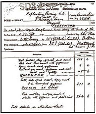
Boreholes range from one to several thousand metres deep. Borehole records are produced from a geologist’s or surveyor’s observations of the rock core extracted from the ground and typically include locality and lithological descriptions with depth and thickness. Geophysical logs may also be noted from on-site measurements.
National well archive
Searching BGS borehole records also gives you access to the the National Well Record Collection. It contains more than 130 000 classified records of wells, boreholes and springs within England and Wales; a unique database of hydrogeological information.
On-site measurements that may be noted are:
- water level measurements
- geochemistry data
Terms and conditions
- The ownership and copyright of the borehole scans (hereinafter referred to as ‘the Records’) will at all times be retained by UK Research and Innovation (UKRI) and/or the commissioning authority under whose auspices the relevant work was carried out.
- The Records are supplied on a non-exclusive basis, for use by you/your organisation. The Records may only be used for:
- personal/private use
- academic activities
- internal business purposes
- commercially, in reports
- Extracts of materials derived from the Records may be reproduced in analogue (paper/hardcopy) and/or in any non-queryable electronic format (e.g. within an appropriately secured .PDF document) in connection with the activities described at 2 above.
- Subject to any prior written arrangements with British Geological Survey (hereinafter referred to as ‘BGS’), no part of any of the Records may be traded, sold or in any other way supplied/made available to any third party as part of any commercial (fee-bearing) record provision or information service.
- The following acknowledgement should accompany material derived from the Records under 3 above: ‘Based upon records provided by British Geological Survey (UKRI).’
- The Records are provided ‘as-is’ on the understanding that they has been created using data capture standards and methodologies considered appropriate at the time of their creation. The Records have not been subjected to current BGS standards of scrutiny and approval.
- The use of information provided by the NGDC is at the users own risk. Where NGDC is providing 3rd party information deposited via sources outside the British Geological Survey (BGS), neither BGS nor our data creators or donors can give any warranty as to the quality or accuracy of that information or its suitability for any use. Therefore all implied conditions relating to the quality or suitability of that information, and all liabilities arising from the supply of the information are excluded to the fullest extent permitted by law.
- The data, information and related records supplied by NGDC should not be taken as a substitute for specialist interpretations, professional advice and/or detailed site investigations. You, as user, should seek professional advice before making technical interpretations on the basis of the materials provided.