BGS completes first mapping expedition to Ascension Island
BGS marine geoscientists travelled to Ascension Island to support its government with an ongoing, conservation-driven mapping programme.
11/12/2023 By BGS Press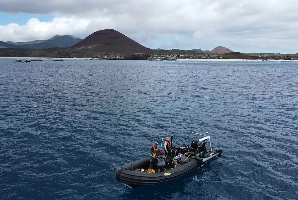

On 30 October 2023, BGS project manager and senior surveyor Rhys Cooper and marine geoscientist Catriona Macdonald took the 4000-mile journey to Ascension Island, an isolated volcanic island in the Atlantic Ocean, to undertake the first stage of a UK Government-funded project.
In 2019, BGS was awarded funding from the UK Government through Darwin Initiative, a grant scheme by the Department for Environment, Food and Rural Affairs (Defra) that funds projects aiming to protect unique biodiversity and improve resilience to climate change within the UK Overseas Territories. Following a four-year delay due to COVID-19, the project is now underway. The first expedition focused on mapping the shallow waters surrounding Ascension Island, including an area of the island that has never been mapped or surveyed before.
Working with the Ascension Island Government, this BGS-led project will determine the character, distribution and extent of the nearshore habitats of the Ascension Island Marine Protected Area (AI-MPA) through an integrated programme of surveys. The AI-MPA is rich in biodiversity; however, protected areas such as this are most at risk from anthropogenic development and climate change.
We've had a fantastic couple of weeks working with Rhys and Catriona from the @BritGeoSurvey !
The duo spent 10 days mapping #Asi's shallow waters on board the Moray with our team – no easy feat given Ascension's choppy waters!#smallislandBIGVISION
🎶:https://t.co/EUchP4ZcyO pic.twitter.com/aolJyuMgO3— Ascension Island MPA (@AscensionMPA) November 16, 2023
Resulting sea-floor habitat maps will provide the Ascension Island Government with urgently needed tools to better monitor and protect marine ecosystems, as well as underpin the evidence-based management of the AI-MPA. The data will be merged with an existing dataset collected by the Royal Navy UK Hydrographic Office (UKHO) in 2021, which has already enabled the deployment of an array of sensors to monitor the movement of sharks. The combined datasets will also allow the first detailed geomorphology, substrate and habitat maps to be produced for the island, down to a maximum depth of 1000 m.

Ascension Island is a remote location and therefore presents many unique challenges that need to be overcome if we are to be successful. We have had numerous delays that proved fortuitous: the Royal Navy completed a survey around Ascension Island during COVID-19 lockdowns, which significantly reduced the amount of data we needed to collect, lowering costs and enabling us to refine and focus our survey campaigns.
The Ascension Island Government owns a boat that was made available to the project. This simplified logistics but required a totally different methodology for deploying the survey equipment. An appropriate solution was found and trialled in the UK before shipping the equipment to Ascension Island. This ‘warm-up’ survey allowed us to check it worked, was safe to operate and ensured we had all the equipment needed.
Rhys Cooper, project manager and senior surveyor.
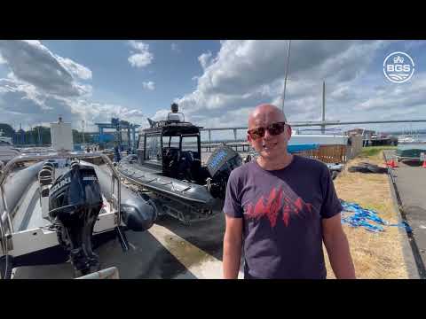

Ascension Island expedition preparation in Port Edgar. BGS © UKRI
The team is set to return to Ascension Island in January 2024 to complete the next stage of the project, which will focus on seabed sampling. A high-definition drop camera with laser scaling will be deployed to enable accurate mapping of the sea floor. The project is expected to be completed in April 2024.
This project is funded by the UK Government through Darwin Plus.

Relative topics
Related news

New NERC-funded project empowers young people to engage with environmental science
23/07/2026
BGS is part of a new, collaborative project, funded through NERC’s ‘Opening up the environment’ programme, helping the environmental research community become more accessible.

Geo-Explorers – after-school kids’ clubs
Event from 07/09/2026 to 07/12/2026
An after school club for junior geology enthusiasts

Building Europe’s geological future
20/07/2026
BGS scientists are contributing to a continent-wide initiative that is strengthening collaboration across borders to tackle shared subsurface challenges and unlock new opportunities.

Delving deep into mountains for future water security
16/07/2026
A BGS-led project is using new water-tracing investigation methods, geophysics and modelling to understand how water moves from mountains to the lowlands, helping to improve water security for billions of people.

Collecting beach pebbles: fun hobby but is it legal?
14/07/2026
The UK coastline will be inundated with keen holidaymakers this summer, many of whom will take a memento of their trip home in the shape of a pebble or two — but is it legal?

Updated national 3D model will determine the depth to the solid bedrock beneath our feet
13/07/2026
The BGS Superficial Deposit Thickness Model now includes an elevation model of geological rockhead for the first time, providing important data for civil engineers, geoscientists and environmental scientists.

UK’s world-class research organisations launch new collective
10/07/2026
The launch of the National Research Organisations Group brings together more than 100 science leaders to provide an authorativive voice on science, research policy and long-term investment.

Cheshire Geoenergy Observatory releases key geological datasets for UK thermal energy storage scheme design
09/07/2026
A new report and data packs from BGS will provide a unique resource for scientists working on the geology and hydrogeology of the Sherwood Sandstone Formation, an important aquifer and reservoir rock.

New geological mapping underway to help manage flooding along the River Tweed
08/07/2026
Scientists are surveying the Tweed catchment for the first time in over 100 years to enhance understanding of localised groundwater and improve flood forecasting.

Geological research in North Sea helping to safeguard subsea cables
06/07/2026
Subsea power and telecommunications cables are critical to the UK’s energy infrastructure and global connectivity, yet they remain vulnerable to damage from ship anchors, fishing activity and natural hazards.

UK Critical Minerals Intelligence Centre makes recommendations for the next UK criticality assessment
01/07/2026
CMIC has outlined the enhancements made to the next assessment update to ensure it is better tailored to the structure of the UK economy.

From archive to discovery: historical mineral reports support gold exploration in Scotland
25/06/2026
Digitised geological records show potential to unlock untapped mineral resources in Ardlochan, Argyllshire.