What lies beneath Loch Lomond?
BGS geoscientists have visualised what lies beneath the waves of Loch Lomond, revealing an image of the loch bed and various sedimentary features of the subsurface.
17/10/2023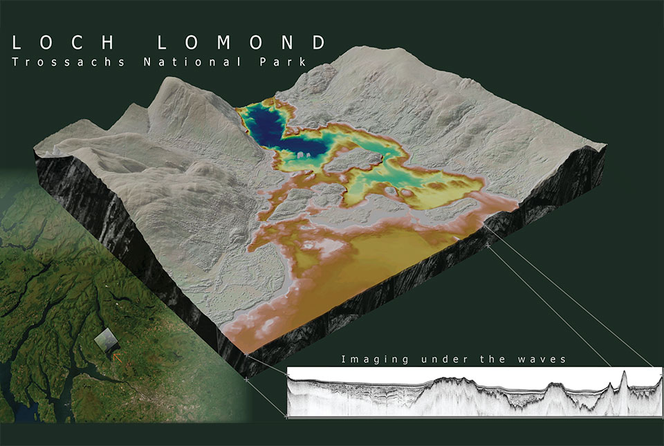

Loch Lomond is a freshwater lake at the heart of the Loch Lomond and Trossachs National Park in the south-west highlands of Scotland. It is surrounded by beautiful landscapes and vistas influenced by past ice ages.
Using seismic data, marine geoscientists at BGS have discovered a new sedimentary unit buried in deposits beneath the loch, giving new insights into its past glacial history.
Scotland in the last ice age
Much of the highlands of Scotland were covered by an extensive mountain ice cap 12 900 to 11 700 years ago, during the last period of cold climate (known as the Younger Dryas or the Loch Lomond Stadial). Decades of onshore research have shown how past ice ages have shaped the landscape of Loch Lomond, including carving of the present-day loch itself and its surroundings through processes such as erosion and deposition. However, this new dataset provides an interpretation of the stratigraphy now buried beneath the loch.
Mapping the loch bed and subsurface features
BGS used multibeam bathymetry surveys to gather detailed information about the features on the loch bed. The data revealed a series of flat-topped and prograding features (or the growth of a river delta further out into the sea over time) and ancient glacial geomorphological features. These features include drumlins, which are oval-shaped hills largely composed of glacial drift that form parallel to the direction of ice flow, and streamlined bedrock, created by glacial restructuring of hard beds that produces a collection of extended rock landforms, interpreted as showing the direction of the palaeo-ice advance.

It’s been incredibly exciting to have had the opportunity to interpret these datasets and present the loch surface and subsurface in a way we’ve never seen before. The seismic mapping and interpretation of the Inchmurrin Formation helps us understand past landscapes and geological events that are now buried under the loch bed. We are keen to undertake further research in and around the area, building on the seismostratigraphical framework that we observe in Loch Lomond.
Nicola Dakin, BGS marine geoscientist.
BGS geoscientists used seismic data to map the subsurface of the loch. Seismic data uses sound waves, which travel through buried layers of sediment, forming an acoustic image based on density variations between different sediment types. We interpreted the acoustic signature, linking sedimentary processes and depositional environments to past climatic cycles. This provided a framework to create an updated chronostratigraphy within the loch.
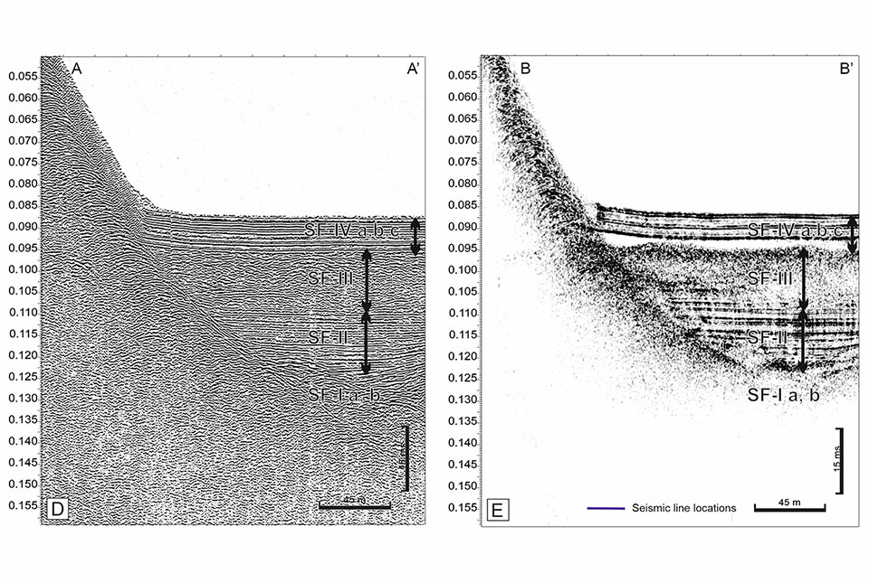
(A) Boomer and (B) EdgeTech data enabled a visual comparison of the stratigraphy imaged by different acquisition systems BGS © UKRI.
What did the survey reveal?
- during glacier advance associated with the cold Younger Dryas climate, glacial landforms were shaped underneath the ice; these can now be identified at the base of the sedimentary succession, up to 60 m below the loch bed surface
- as the ice retreated, vast volumes of water and sediment were released into the loch, leaving a sequence of layered sediments up to 44 m thick
- immediately after deglaciation of the area, exposure of steep loch margins likely resulted in landslides into the loch, producing a unit that is shown as a transparent layer in the seismic data and can represent up to 50 per cent of the sediment fill in places — we have named this new unit the ‘Inchmurrin Formation’
- as the climate transitioned from the early Holocene to the present day, a final phase of lacustrine sedimentation followed, depositing up to 127 m of the youngest, layered, grey-brown lake sediments
Global value of this work
Work is continuing to build understanding of other lochs in the area. The Loch Lomond dataset is a valuable resource that could enable BGS to offer insights into the extent and rates of landscape adjustment that accompanied the transition from glacial to non-glacial conditions. Such findings are of global importance when considering landscape stability and potential future geohazards in regions that are undergoing rapid deglaciation, such as around the European Alps, Himalayas and New Zealand’s Southern Alps.
About the author

Nicola Dakin
Marine geoscientist
Relative topics
Related news

New NERC-funded project empowers young people to engage with environmental science
23/07/2026
BGS is part of a new, collaborative project, funded through NERC’s ‘Opening up the environment’ programme, helping the environmental research community become more accessible.

Geo-Explorers – after-school kids’ clubs
Event from 07/09/2026 to 07/12/2026
An after school club for junior geology enthusiasts

Building Europe’s geological future
20/07/2026
BGS scientists are contributing to a continent-wide initiative that is strengthening collaboration across borders to tackle shared subsurface challenges and unlock new opportunities.

Delving deep into mountains for future water security
16/07/2026
A BGS-led project is using new water-tracing investigation methods, geophysics and modelling to understand how water moves from mountains to the lowlands, helping to improve water security for billions of people.

Collecting beach pebbles: fun hobby but is it legal?
14/07/2026
The UK coastline will be inundated with keen holidaymakers this summer, many of whom will take a memento of their trip home in the shape of a pebble or two — but is it legal?

Updated national 3D model will determine the depth to the solid bedrock beneath our feet
13/07/2026
The BGS Superficial Deposit Thickness Model now includes an elevation model of geological rockhead for the first time, providing important data for civil engineers, geoscientists and environmental scientists.

UK’s world-class research organisations launch new collective
10/07/2026
The launch of the National Research Organisations Group brings together more than 100 science leaders to provide an authorativive voice on science, research policy and long-term investment.

Cheshire Geoenergy Observatory releases key geological datasets for UK thermal energy storage scheme design
09/07/2026
A new report and data packs from BGS will provide a unique resource for scientists working on the geology and hydrogeology of the Sherwood Sandstone Formation, an important aquifer and reservoir rock.

New geological mapping underway to help manage flooding along the River Tweed
08/07/2026
Scientists are surveying the Tweed catchment for the first time in over 100 years to enhance understanding of localised groundwater and improve flood forecasting.

Geological research in North Sea helping to safeguard subsea cables
06/07/2026
Subsea power and telecommunications cables are critical to the UK’s energy infrastructure and global connectivity, yet they remain vulnerable to damage from ship anchors, fishing activity and natural hazards.

UK Critical Minerals Intelligence Centre makes recommendations for the next UK criticality assessment
01/07/2026
CMIC has outlined the enhancements made to the next assessment update to ensure it is better tailored to the structure of the UK economy.

From archive to discovery: historical mineral reports support gold exploration in Scotland
25/06/2026
Digitised geological records show potential to unlock untapped mineral resources in Ardlochan, Argyllshire.