Largest CT core scan completed at the BGS Core Scanning Facility
BGS has completed its largest CT core scan project to date, with around 400 m of core imaged for the IODP Drowned Reefs project.
09/05/2024 By BGS Press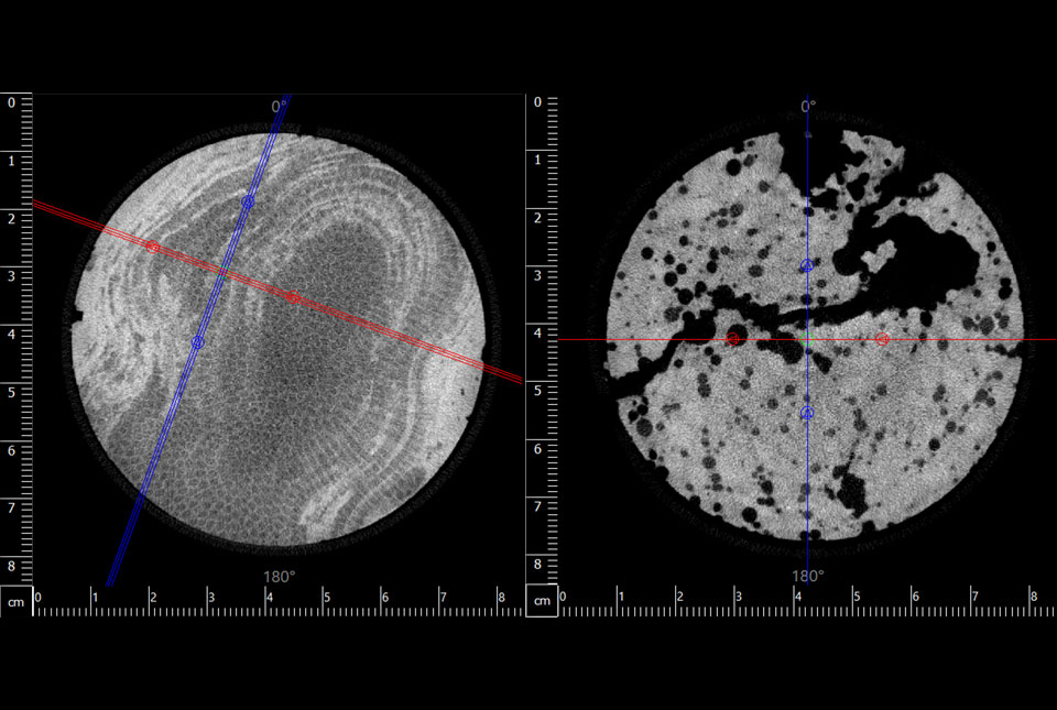

The Core Scanning Facility (CSF) at BGS has successfully completed the largest computed tomography (CT) core scanning project at this facility to date. Approximately 400 m of core from the International Ocean Discovery Program (IODP) Expedition 389: Hawai’ian Drowned Reefs project was scanned through the rotating X-ray CT (RXCT) core scanner to produce a three-dimensional X-ray image of the core.
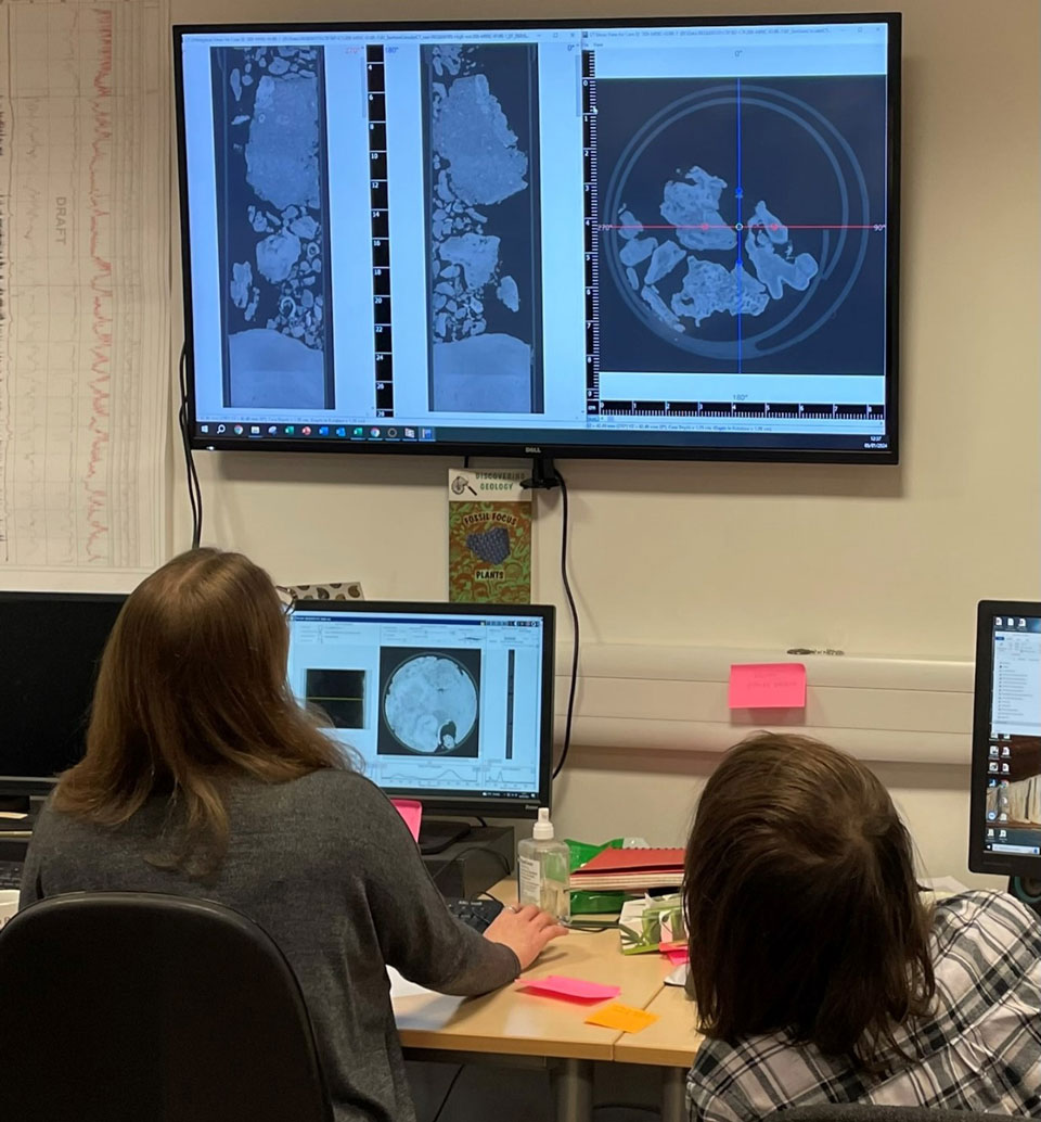
CSF staff, Elisabeth Steer (left) and Owen Rathbone (right), viewing the CT imagery after it is being reconstructed. © Marisa Rydzy, ECORD/IODP.
IODP is an international marine research programme that explores Earth’s history and structure that has been recorded in sea-floor sediments and rocks, and monitors sub-seafloor environments. Expedition 389 focuses on the submerged fossil reefs off the coast of Hawai’i where changes in sea level and global climate are preserved in a greatly expanded and near-continuous fossil coral record covering the last half a million years.
The core samples from the expedition were transported in large, refrigerated containers and kept at 4°C. A coordinated operation involving BGS’s estates, goods-in and Core Store teams, in addition to a telehandler and forklifts, were deployed on arrival to unload the core and move the stillages prior to being scanned.
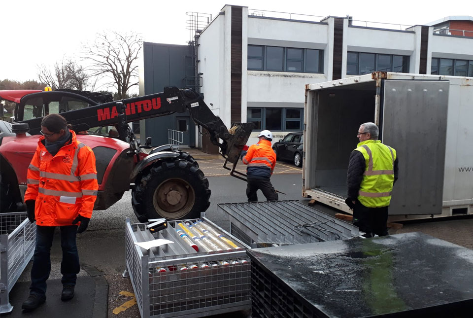
IODP core being delivered in large, refrigerated containers that are put into position using a telehandler, organised by the BGS Estates team. © Marisa Rydzy, ECORD/IODP.
The CSF staff and 21 volunteers worked 24/7, covering two shifts over the course of a two month-period. The team successfully delivered a unique dataset that will be used for years to come. Core was scanned at a resolution of 93 µm for high-priority core and 186 µm for the rest. The priority order was set out by the offshore science party and was based on core condition and scientific importance.

Seeing the core scanner run non-stop for 516 hours without any downtime is truly astonishing. This highlights the importance of regular maintenance activities and functionality and safety tests of the machinery we host at BGS.
Magret Damaschke, BGS Core Scanning Facility Manager.
CT produces large amounts of data (both raw and reconstructed), with terabytes of data being generated every couple of days. Data management was therefore at the forefront of core-scanning workflows. This helped the team to avoid overloading transfer and archiving of data drives, which could result in bottlenecks when handling such a large dataset.
This CT dataset provides the scientists with a three-dimensional X-ray image of the core. The resultant CT imagery was used by the IODP’s onshore science party in Bremen to gain detailed insight into the inner structure of the core collected during the Hawai’ian Drowned Reefs expedition. It provided the opportunity to make an informed decision where to split the core to preserve coral structures and growth patterns for future scientific analysis. In addition, CT scans can be used to generate downhole radiodensity profiles to identify potential lithological or facies changes. Specialised CT image segmentation tools allow coral species and populations to be characterised, as well as basalt porosity analysis to be performed.
The onshore science party found the CT data to be incredibly useful during sampling and commented that the images were far more informative and detailed than anticipated. Post-sampling, scientists have already discovered more coral species ‘hiding’ within the cores, which were not visible during core description.
Dr Hannah Grant, BGS Marine Geoscientist and expedition project manager.
Many thanks again for all your team’s hard work with the X389 samples. The CT scan data is already proving to be incredibly valuable. One of my colleagues just sent me an image of a particular coral genus that is not supposed to be in Hawai’i! It only revealed itself after examination of the CT scan data.
Jody Webster, co-chief scientist on IODP Expedition 389.
Relative topics
Related news

Building Europe’s geological future
20/07/2026
BGS scientists are contributing to a continent-wide initiative that is strengthening collaboration across borders to tackle shared subsurface challenges and unlock new opportunities.

Delving deep into mountains for future water security
16/07/2026
A BGS-led project is using new water-tracing investigation methods, geophysics and modelling to understand how water moves from mountains to the lowlands, helping to improve water security for billions of people.

Geological research in North Sea helping to safeguard subsea cables
06/07/2026
Subsea power and telecommunications cables are critical to the UK’s energy infrastructure and global connectivity, yet they remain vulnerable to damage from ship anchors, fishing activity and natural hazards.

Ukraine and the UK strengthen their commitment to geological cooperation
10/06/2026
A new Memorandum of Understanding reaffirms the UK’s support of Ukraine’s ambitions to develop its critical mineral resources, paving the way for collaboration through capacity-building programmes.

International science consortium to survey the health, economic value and social importance of Lake Victoria
22/05/2026
The project will replicate the 1927 survey to assess changes in the lake’s health, economic value and social importance.

BGS contributes to UN sand and sustainability report
19/05/2026
The new report highlights the impact of poor governance and unsustainable sand mining practices, calling on policymakers to take action.
BGS engineering geologist elected to CCOP
29/04/2026
Marcus Dobbs has been elected as vice-chair of the advisory group for the Coordinating Committee for Geoscience Programmes in East and Southeast Asia.

Strengthening capacity through partnership: a critical minerals perspective
28/04/2026
BGS has been working in partnership with the Geological Survey Department of Zambia (GSD) to build national capacity, improve data accessibility and support long-term, sustainable development.

UK scientists unite for seabed mapping survey of the UK’s south-west coastline
15/04/2026
BGS geologists join research voyage, gathering crucial geological data to support offshore energy and infrastructure projects.

Updated geological assessment of the Southern North Sea set to underpin future offshore infrastructure development
25/03/2026
The first regional assessment for 30 years will support offshore marine and subsurface planning for the UK’s low-carbon energy infrastructure, including the 2030 target of 45 to 50 GW generated through offshore wind.

New research could help provide a more reliable water supply for millions in rural Africa
24/03/2026
A new BGS-led study has revealed crucial insights into the longstanding challenges affecting the reliability and performance of rural water supply infrastructure in sub-Saharan Africa.

New UK/Chile partnership prioritises sustainable practices around critical raw materials
09/02/2026
BGS and Chile’s Servicio Nacional de Geología y Minería have signed a bilateral scientific partnership to support research into critical raw materials and sustainable practices.