Artificial intelligence is proving a game changer in tracking the Santorini earthquake swarm
Scientists are harnessing the power of machine learning to help residents and tourists by detecting thousands of seismic events.
07/02/2025 By BGS Press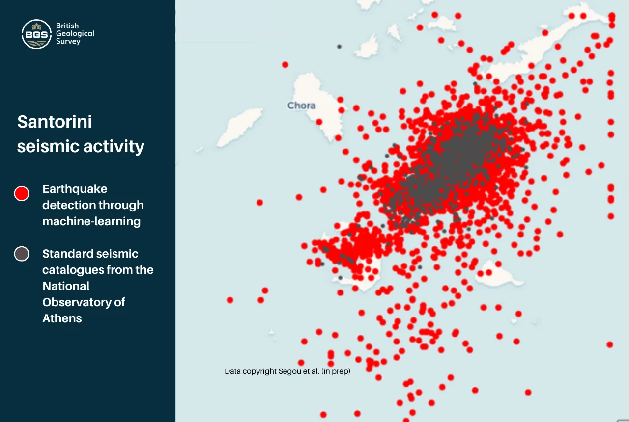

As a state of emergency is declared on the Greek island of Santorini, seismologists are increasingly turning to artificial intelligence technology to provide high-resolution images of the ongoing seismic activity, in a bid to enhance short-term forecasting accuracy.
Since the start of the crisis, a team from BGS comprising Margarita Segou, Brian Baptie, Rajat Choudhary, Wayne Shelley and Foteini Dervisi, has been employing machine learning algorithms to detect ten times as many earthquakes as standard techniques, with over 20 000 tremors accurately predicted in the Santorini area alone since 1 December 2024. This approach is allowing geologists to identify for the first time small magnitude earthquakes that were previously undetected using standard approaches.
BGS Seismologist Margarita Segou, who is leading the development of the groundbreaking research, says it has revolutionised the way scientists can learn from seismic activity and predict patterns.

This machine learning technique results in far richer data feeding into short-term forecasts, which can allow experts to track the evolution of events and better advise emergency services and at-risk communities.
Dr Margarita Segou, BGS Seismologist.
These algorithms allowed researchers to first note increased seismic activity across the Santorini region on 26 January 2025. In comparison, standard detection schemes did not register the same increase until 31 January and only picked up around 2000 seismic events in the Santorini area; ten times less than the new approach has detected.
Dr Segou says it is the ability to combine different sources of information more quickly that is at the heart of the advancement.
Through strong international partnerships, we can reprocess past and present data through machine learning and gain a new and priceless insight into the seismic activity in Santorini in previous phases of unrest and its links to the volcanic system.
Dr Margarita Segou.
Santorini is located on the Hellenic volcanic arc at the convergence of the African plate and the Eurasian plate, at a complex tectonic boundary. Currently, seismic events around the island show that seismicity bursts occur almost twice a day, with the tremors lasting for one to two hours.
Dr Segou adds the data is revealing some unique features.
We have evidence that this is fluid-driven, swarm-type seismicity that comes in pulses. This is not unheard of in other volcanic regions; however, this time it is evolving on top of active faults that complicate the expression of seismicity.
It is easy to get a disconnected story when we just look at moderate magnitude seismic events. It is only when we investigate the smaller magnitude events that occur between that we learn of the hidden mechanisms that take place between the large earthquakes.
It is critical that we track whether those pulses become more frequent and how they migrate in space and depth. So far, the largest quake in this swarm has been a 5.2 magnitude.
Dr Margarita Segou.
Contact
For more information, please contact BGS press (bgspress@bgs.ac.uk) or call 07790 607 010.
Relative topics
Related news

Delving deep into mountains for future water security
16/07/2026
A BGS-led project is using new water-tracing investigation methods, geophysics and modelling to understand how water moves from mountains to the lowlands, helping to improve water security for billions of people.

Collecting beach pebbles: fun hobby but is it legal?
14/07/2026
The UK coastline will be inundated with keen holidaymakers this summer, many of whom will take a memento of their trip home in the shape of a pebble or two — but is it legal?

New geological maps of Berwick-upon-Tweed to help future-proof natural water supply
20/05/2026
Scientists have mapped the geology under the town to better understand the groundwater system to inform decisions around abstraction.

BGS contributes to UN sand and sustainability report
19/05/2026
The new report highlights the impact of poor governance and unsustainable sand mining practices, calling on policymakers to take action.

New research could help provide a more reliable water supply for millions in rural Africa
24/03/2026
A new BGS-led study has revealed crucial insights into the longstanding challenges affecting the reliability and performance of rural water supply infrastructure in sub-Saharan Africa.

PhD adventures in Copenhagen, Denmark: revealing past recovery processes of tropical forest systems through ancient environmental DNA
12/03/2026
PhD student Chris Bengt visited the University of Copenhagen to carry out very delicate extraction of aeDNA from lake-sediment cores, in the hopes of unlocking the secrets of past volcanic eruptions.

Extensive freshened water confirmed beneath the ocean floor off the coast of New England for the first time
09/02/2026
BGS is part of the international team that has discovered the first detailed evidence of long-suspected, hidden, freshwater aquifers.

Funding secured to help mitigate ground risk in UK construction sector
05/02/2026
The BGS Common Ground project has been awarded new funding to help unlock the value of ground investigation data.

Hole-y c*@p! How bat excrement is sculpting Borneo’s hidden caves
23/12/2025
BGS researchers have delved into Borneo’s underworld to learn more about how guano deposited by bats and cave-dwelling birds is shaping the subsurface.

New geological maps of the Yorkshire Wolds to better inform groundwater management and policy decisions
17/12/2025
The new mapping provides crucial data on localised geological issues that may assist in protecting water supplies.

New 3D model to help mitigate groundwater flooding
08/12/2025
BGS has released a 3D geological model of Gateshead to enhance understanding of groundwater and improve the response to flooding.

Latest BGS Geology 50K mapping data launched
06/11/2025
Some of our most widely used maps have received a major update, including the 1:50 000-scale map series that now includes enhanced coverage of Great Britain.