New research reveals the secrets of the seabed off the East Anglian coast
New geological map will help in the hunt for new renewable energy opportunities whilst protecting delicate marine ecosystems.
11/07/2024 By BGS Press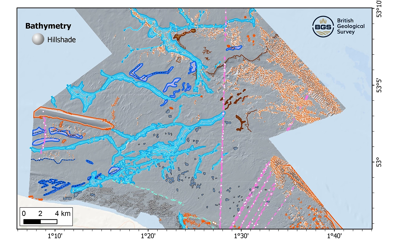
For the first time in 25 years, new geological data has been used to create an offshore East Anglia fine-scale (1:10 000) map. The map captures essential insights that will prove invaluable in the pursuit of further renewable energy development in the area, whilst allowing for better protection of nationally important habitats and species. The map, released by BGS, reveals hidden geological features of the seabed offshore north-east Norfolk. It provides new insights into the longer-term geological evolution of the region, including the extent and legacy of glaciation that affected the area during the geological past.
Results of the research include:
- the first high-resolution geological map of the offshore area around north-east Norfolk
- mapping of a prominent area of an offshore chalk (bedrock) reef, a rare ecological habitat that has been designated a Marine Conservation Zone
- geology is dominated by superficial (Pleistocene) deposits and landforms that record the eastwards growth of a large delta followed by several phases of glaciation
The map has been created by the interpretation of high-resolution bathymetric data captured by the Maritime and Coastguard Agency, shallow seismic data and historical sediment samples.
The opportunities presented by this enhanced understanding of a vital part of the UK’s offshore environment are considerable, providing the tools to support a diverse range of offshore activities and applications, including scientific research, offshore development, conservation efforts and marine management.
It is particularly interesting that we have mapped an extensive area of offshore chalk reef that corresponds to a designated Marine Conservation Zone. The mapping has also identified widespread geological and geomorphological evidence for the longer-term, ice age history of the offshore region, complementing knowledge gathered onshore from adjacent north-east Norfolk.
Collectively, this new geological mapping will help a range of users understand the geology of the seabed, enabling them to make more effective and informed decisions about how to manage or interact with it.
Dr Jonathan Lee, BGS Quaternary Geologist.
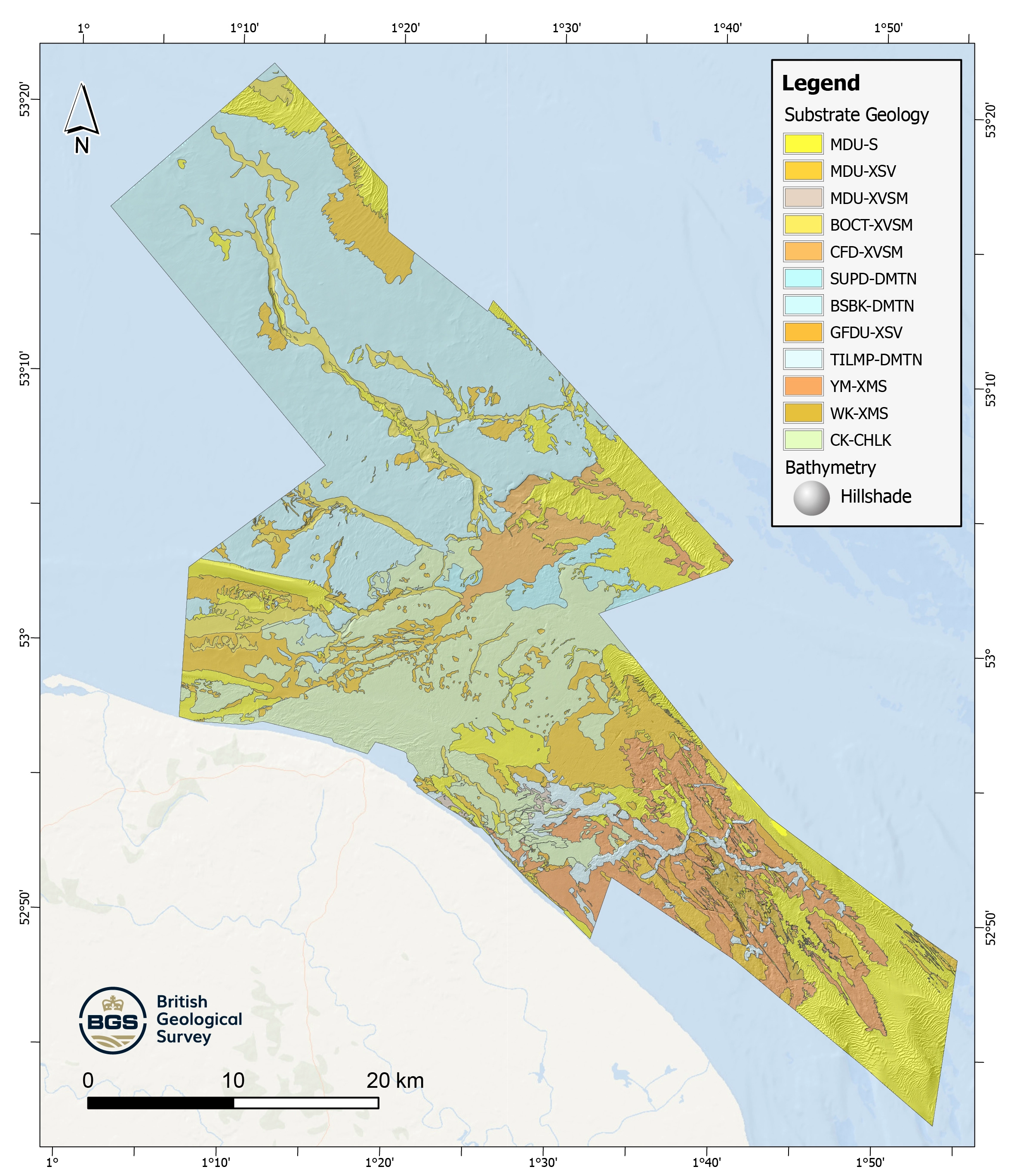
BGS Seabed Geology: offshore East Anglia. BGS © UKRI.
The offshore East Anglia area forms an important region within the nation’s energy infrastructure, being a focus for successive phases of development of offshore renewables, such as windfarms, and related infrastructure. The area is also critical for marine conservation, as it hosts Europe’s longest known offshore chalk reef.
The new offshore East Anglia geological maps are available from BGS under the ‘fine-scale maps’ (1:10 000 scale) section of the Offshore GeoIndex, or as downloadable shapefiles for offline viewing.
Through a greater understanding of the geology below the seabed, the UK can enhance its development of offshore renewable, whilst helping to protect threatened habitats and rare species that are nationally important.
Dr Jonathan Lee.
Notes to editors
The offshore East Anglia geological maps are an interpretation of the seabed, based primarily on high-resolution bathymetric data that includes information about the depths and shapes of underwater terrain. The data is captured through the Maritime and Coastguard Agency’s UK Civil Hydrography Programme.
Geological interpretation is further informed by:
- acoustic backscatter data
- grab samples and sediments
- shallow seismic data
- existing onshore and offshore geological map products
The East Anglia map forms part of a series of new fine-scale maps produced by BGS which are focused on the seabed geology of the UK’s continental shelf.
Related news
BGS digital geology maps: we want your feedback
29/05/2025
BGS is asking for user feedback on its digital geological map datasets to improve data content and delivery.

BGS scientists join international expedition off the coast of New England
20/05/2025
Latest IODP research project investigates freshened water under the ocean floor.
Geology sans frontières
24/04/2025
Geology doesn’t stop at international borders, so BGS is working with neighbouring geological surveys and research institutes to solve common problems with the geology they share.
What does the next generation of coastal environmental models look like?
15/04/2025
A new tool is now available that has been designed to help coastal engineers and practitioners better manage the compound risk of coastal erosion and flooding.
Celebrating 20 years of virtual reality innovation at BGS
08/04/2025
Twenty years after its installation, BGS Visualisation Systems lead Bruce Napier reflects on our cutting-edge virtual reality suite and looks forward to new possibilities.
New seabed geology maps to enable long term conservation around Ascension Island
01/04/2025
BGS deliver the first marine geology and habitat maps for one of the world’s largest marine protected areas.
New study reveals long-term effects of deep-sea mining and first signs of biological recovery
27/03/2025
BGS geologists were involved in new study revealing the long-term effects of seabed mining tracks, 44 years after deep-sea trials in the Pacific Ocean.

BGS announces new director of BGS National Geoscience
12/02/2025
BGS announces its new director of BGS National Geoscience.
Seabed geology data: results from stakeholder consultation
31/01/2025
BGS collected valuable stakeholder feedback as part of a new Crown Estate-led initiative to improve understanding of national-scale seabed geology requirements.
What lies beneath Liverpool?
11/10/2024
The geological secrets lying under the surface of Liverpool and Warrington have been unveiled for the first time in BGS’s 3D interactive tool.
New hazard maps set to help safeguard UK offshore energy industry
12/09/2024
Essential geological model detailing seismic hazard published as the pursuit of new renewable energy infrastructure intensifies.

New appointments to BGS Science Advisory Committee
29/08/2024
The appointments mark the latest step in the ongoing delivery of BGS’s essential geological expertise.


