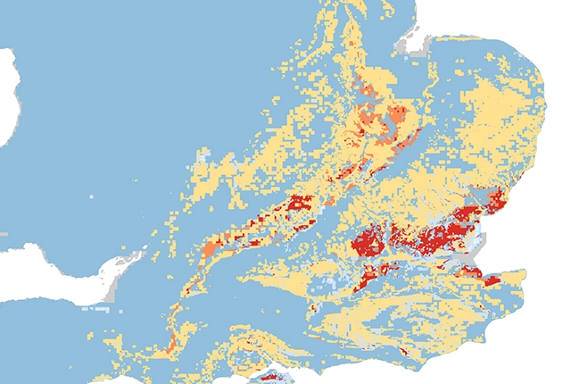

Matrix of sample BGS GeoClimate clay shrink-swell outputs for the wettest, average and driest projected climate conditions in each of the RCPs 2.6, 4.5 and 8.5, for the time period of 2065-2075. BGS © UKRI
- 1:50 000
- Great Britain
- Premium
GeoClimate looks specifically at the geological factors that influence shrink-swell subsidence and the climatic effects/interactions. It does not consider any human or artificial factors. GeoClimate Shrink-swell provides information on the potential for clay shrink-swell subsidence under a range of climate scenarios. The data provide projections for the Representative Concentration Pathways (RCPs) 2.6, 4.5 and 8.5 emission scenarios.
For more information on how this new release compares to and improves upon previous versions of BGS GeoClimate, please see our user update information note.
Key information
- Scale:
- 1:50 000
- Coverage:
- Great Britain
- Availability:
- Premium
- Price:
£0.45 per km2. Bundle price; GeoClimate shrink-swell plus GeoSure shrink-swell of £0.60 per km2.
Discounts may apply depending on area size and term of licence. Please contact us for a quote.
- Format:
- GIS polygon data (Shapefile, others available by request)
- Themes:
- Climate change, Hazards
GeoClimate shrink–swell provides information on the projected future change in susceptibility of clay shrink–swell across Great Britain due to climate change. This version of GeoClimate utilises state-of-the-art climate projection data from the UK Centre for Ecology & Hydrology’s CHESS-SCAPE future climate dataset (Robinson et al., 2023), which is explicitly derived from UKCP18 regional climate model outputs. This dataset is preceded by and replaces the BGS GeoClimate UKCP18 and UKCP09 products, improving upon previous iterations by providing outputs for more representative concentration pathways (RCPs) and a larger number of time periods.
Many soils contain clay minerals that absorb water when wet (making them swell) and lose water as they dry (making them shrink). This ‘shrink–swell’ behaviour is controlled by the type and amount of clay in the soil and by changes in soil-moisture content related to rainfall and local drainage. This shrink–swell variation can cause ground movement, which in turn may damage building foundations, pipes or utility services.
Dry weather and high temperatures are a major factor in the emergence of subsidence in clay soils. Every summer can be completely different to the last; summer 2018 had the hottest, driest June for years whereas summer 2019 had one of the wettest Junes on record. Warmer, drier summers and increases in annual temperature and rainfall variability are predicted, which will cause more shrink–swell activity.
Shrink–swell ground movement, typically reported as subsidence, is one of the most damaging geohazards in Britain today, costing the economy an estimated £3 billion over the past decade. It can lead to financial loss for anyone involved in the construction, ownership or management of property, large structures, infrastructure networks and utilities. These costs could include increased insurance premiums, depressed house prices and, in some cases, engineering works to stabilise land or property.
Armed with knowledge about potential hazards, preventative or mitigative steps can be put in place to alleviate the effects of the hazard on property and infrastructure. The cost of such prevention may be very low and is often many times lower than the repair bill following ground movement
Further information
GeoClimate looks specifically at the geological factors that influence shrink–swell subsidence and the climatic effects and interactions. It does not consider any human or artificial factors. GeoClimate shrink–swell provides information on the potential for clay shrink–swell subsidence under a range of climate scenarios. The data provides projections for the RCPs 2.6, 4.5 and 8.5 emission scenarios.
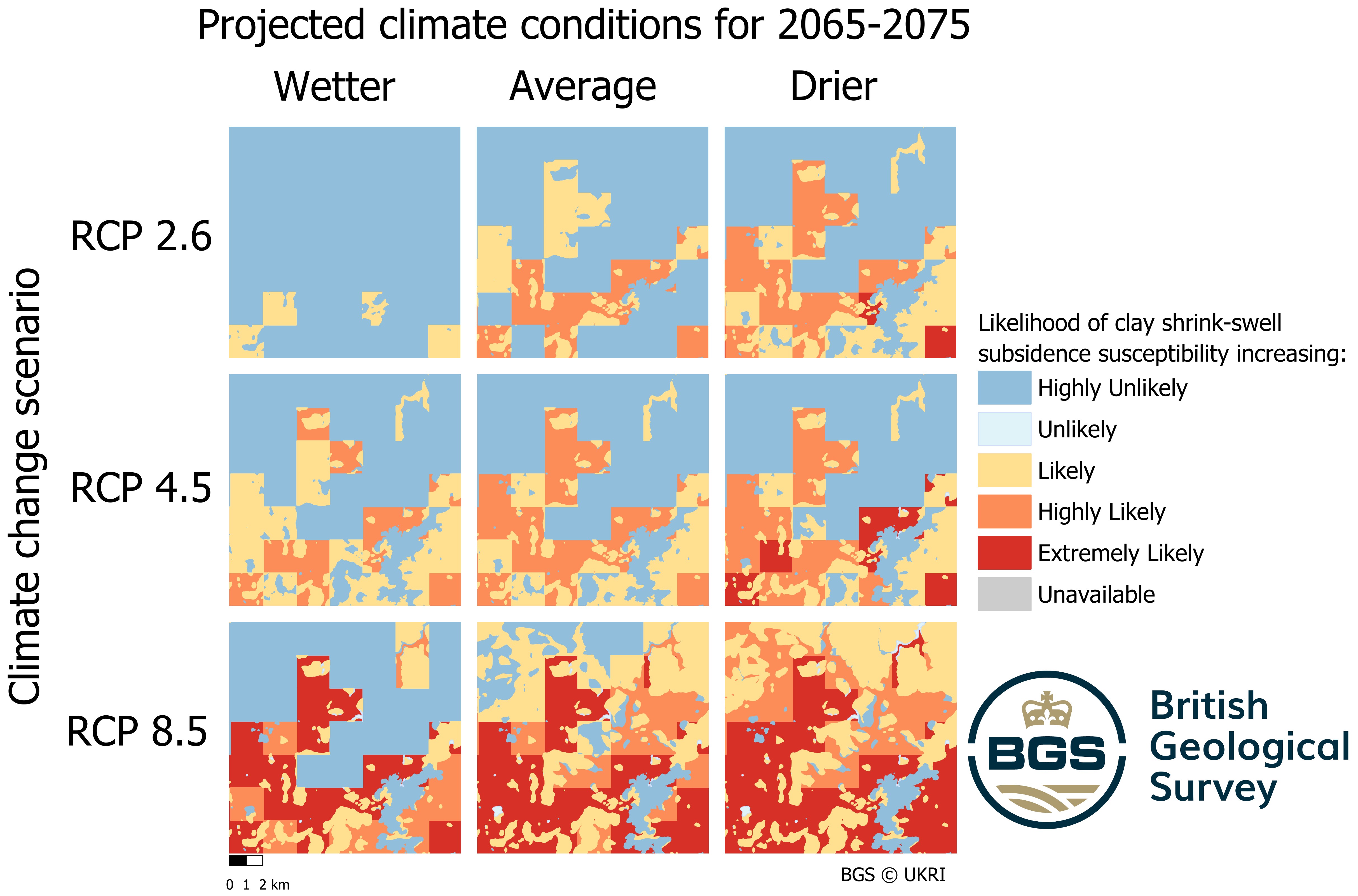
Matrix of sample BGS GeoClimate clay shrink–swell outputs for the wettest, average and driest projected climate conditions in each of the RCPs 2.6, 4.5 and 8.5, for the time period of 2065 to 2075. BGS © UKRI
GeoClimate clay shrink–swell is a national geological dataset produced by BGS and is provided at a quasi-1:50 000 scale. It is based on the best and most appropriate resolution datasets available at national scale and coverage — the 1:50 000 BGS geological data and 1 km grid CHESS-SCAPE climate projection data. CHESS-SCAPE is a high-resolution downscaled dataset derived from the UKCP18 12 km regional climate model ensemble. GeoClimate clay shrink–swell has almost complete coverage of Great Britian (not including some Hebridean islands, Shetland and parts of Orkney).
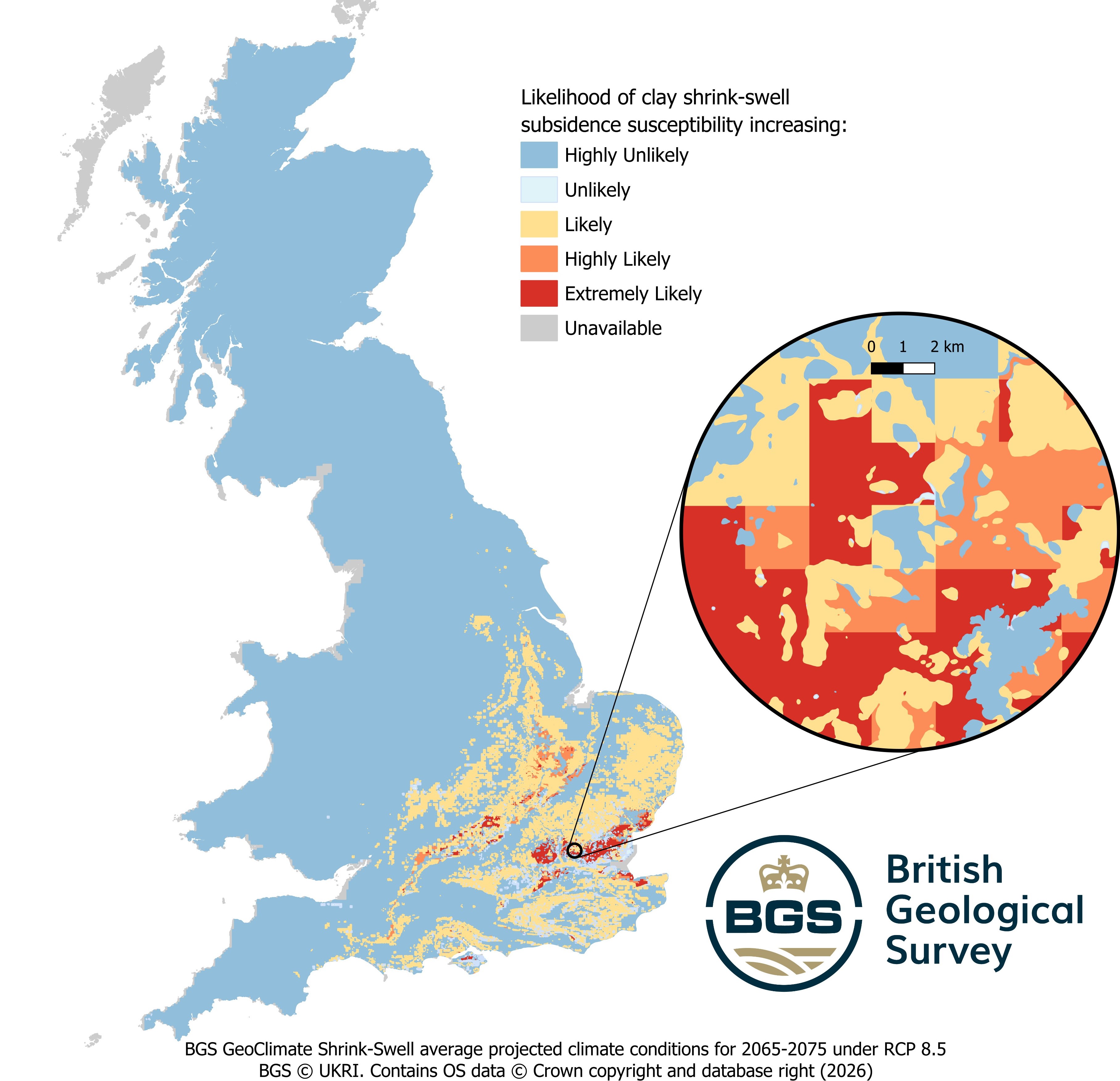
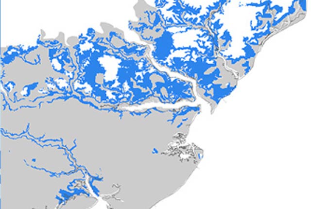
Demonstration of data coverage for GeoClimate clay shrink–swell. This instance shows the output for the average projected climate conditions for 2065 to 2075 under RCP 8.5. BGS © UKRI.
Additional dataset information
| Features | GeoClimate clay shrink-swell |
|---|---|
| Temporal projections (11-year windows) | 2030 (2025–2035)
2050 (2045-2055) 2070 (2065–2075) |
| Historical time period (11-year window) | 1996 (1991 to 2001) |
| Emissions scenarios | RCP2.6
RCP4.5 RCP8.5 |
| Climate model projection | CHESS-SCAPE (a high-resolution downscaled dataset derived from the UKCP18 regional climate model ensemble). |
| GeoClimate categories | Five (highly unlikely to extremely likely) |
| Climate data scale | Daily 1km grid |
| Outputs | 36 in total: medium, drier, wetter and difference (for each RCP and each time period) |
| Format | ESRI vector polygon data |
| Difference maps | Nine: one for each RCP time period |
Figure 1 Additional dataset information for GeoClimate clay shrink–swell
| Colour | Class | |
|---|---|---|
| Blue | Highly unlikely | It is highly unlikely that foundations will be affected by increased clay shrink-swell due to climate change. |
| Light Blue | Unlikely | It is unlikely that foundations will be affected by increased clay shrink-swell due to climate change. |
| Yellow | Likely | It is likely that foundations will be affected by increased clay shrink-swell due to climate change. |
| Orange | Highly likely | It is highly likely that foundations will be affected by increased clay shrink-swell due to climate change. |
| Red | Extremely likely | It is extremely likely that foundations will be affected by increased clay shrink-swell due to climate change. |
| Grey | Unavailable | Input datasets unavailable. |
Figure 2 GeoClimate clay shrink–swell colours, classes and susceptibility descriptors.
FAQs
These questions and answers have been provided to address any potential issues relating to how the product can be used or how it can be interpreted. If you have any additional questions, please contact BGS Digital Data (digitaldata@bgs.ac.uk).
This dataset provides information on the projected future change in susceptibility of clay shrink–swell across Great Britain due to climate change. It considers the changing climate and the associated changes in near-surface groundwater content, as well as the static variables of geology and geotechnical values.
All the GeoClimate datasets have coverage for Great Britain (except some Hebridean isalnds, Shetland and parts of Orkney).
The BGS GeoClimate datasets are available as vector GIS datasets with attribute values relating to shrink–swell hazard susceptibility under a range of climate scenarios. The dataset comprises both polygon and grid data. Please contact BGS Digital Data (digitaldata@bgs.ac.uk) to request further information.
BGS GeoSure Shrink–Swell is a hazard susceptibility rating that does not change for a geological deposit. However, the projected changes in climate vary across Great Britain, therefore the GeoSure shrink–swell rating is combined with climate projections to provide a GeoClimate rating.
GeoSure shrink–swell considers only the physical properties of the geology, whereas GeoClimate considers how these physical properties may be affected in the future as a consequence of projected changes in climate. We provide a 1996 baseline dataset (based on the time period 1991 to 2001) that should be referred to by users interested in the level of modelled ‘change’ from ‘current climatic conditions’.
GeoClimate UKCP18 was only available for RCP 8.5. The CHESS-SCAPE RCP 8.5 average climate projection is slightly drier than UKCP18, providing projections with slightly higher increases in subsidence susceptibility. Overall, the difference in outputs is very comparable, showing the robustness of the CHESS-SCAPE subset of four ensemble members to represent UKCP18.
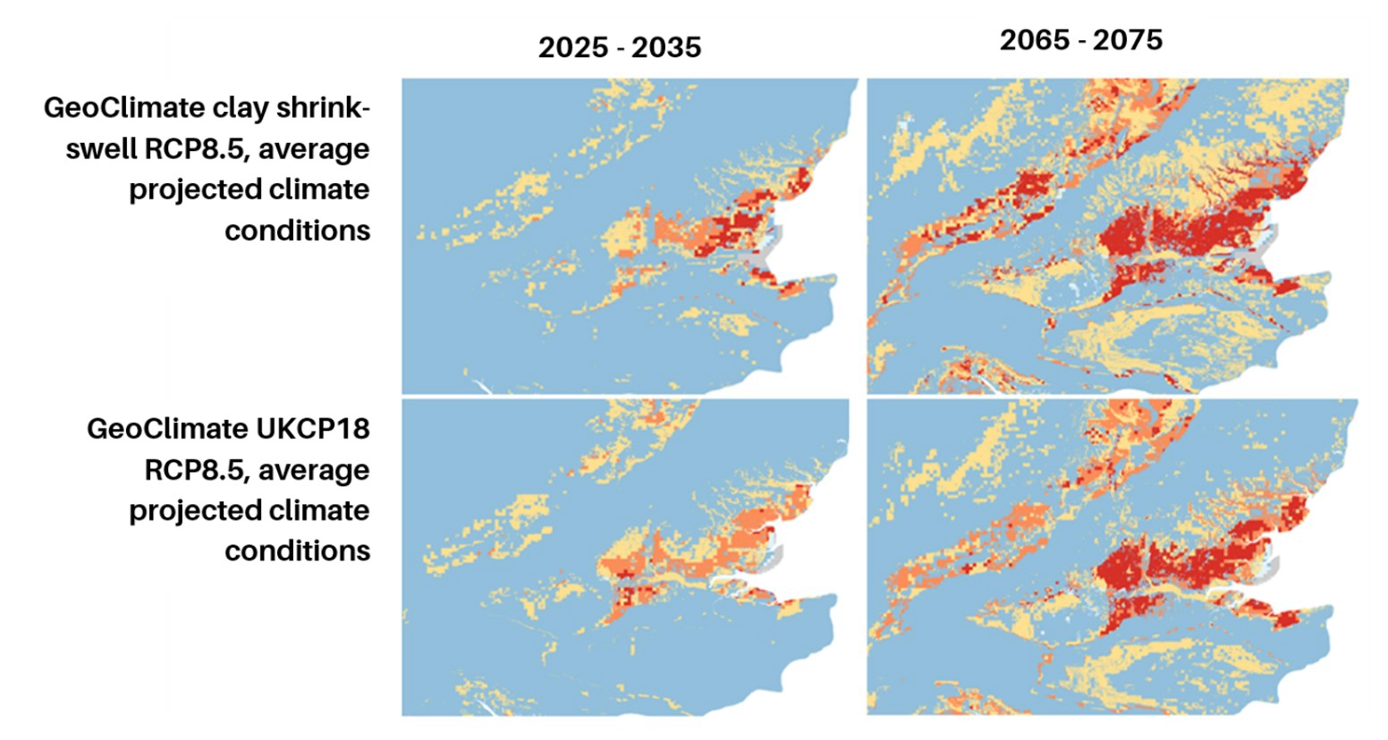
Comparison between GeoClimate clay shrink–swell RCP 8.5 and GeoClimate UKCP18 RCP 8.5 susceptibility projections for 2030 and 2070. BGS © UKRI 2026. Contains OS data © Crown copyright and database right (2026).
The gridded nature of areas of GeoClimate is due to the resolution of the soil-moisture deficit data generated using the BGS Groundwater Model (ZOODRM). This provides an output grid with a resolution of 2 km. Therefore, the grid is clearly visible when it is combined with the geological 1:50 000 polygon dataset in areas where the soil-moisture deficit values lead to a varying GeoClimate classification, across areas of consistent volume-change potential.
Changes in susceptibility are driven by both the mineralogical and lithological characteristics of the geology combined with the climate. Some areas of the country will never experience clay shrink–swell due to the underlying geology; these areas remain ‘improbable’ in every time period. In other areas, the underlying geology contains clay minerals that can shrink and swell due to varying water content but are not yet experiencing fluctuations large enough to trigger visible volume change and ground movement. As climate conditions change and become more extreme, these areas could see increased hazard and impacts.
There is a general relationship that RCP 8.5 is drier than RCP 4.5, which is drier than RCP 2.6 and, the further into the future, the larger the increase in clay shrink–swell susceptibility. However, this is greatly simplified and there are deviations from this due to complexities such as:
• reductions in aerosols accompanying the reduction in greenhouse gas (GHG) emissions: aerosols have a cooling effect and a much shorter lifetime in the atmosphere, leading to non-linear responses and potentially an increase in temperature following rapid mitigation strategies, followed by cooling in the longer term
• lag times of decades in the GHG emissions reductions and impact on global temperatures, due to long lifetime of carbon dioxide (CO2) in the atmosphere
• variation in rainfall infiltration rates due to increasing summer temperatures causing drying of the ground surface and leading to increased runoff
CHESS-SCAPE has four ensemble members, which were chosen to span the range of temperature and precipitation changes in the UKCP18 ensemble, representing the ensemble climate model uncertainty. The GeoClimate shrink–swell methodology therefore provides four soil-moisture deficit values for each grid square. The values from each of the climate realisations are sorted from wettest to driest and the 10th, 50th and 90th percentiles of the model distribution were calculated. The 10th percentile has been used to represent the wetter conditions, the 50th percentile represents median or average conditions and the 90th percentile represents drier conditions.
The reason for the ‘unavailable’ category arises from two different sources. Firstly, not all the input datasets required are available for all of the Scottish islands (including Orkney and Shetland). Therefore, results for these areas are categorised as ‘Input datasets unavailable’. Secondly, various points along the coastline produced extremely high outlying values of soil-moisture deficit during the data processing. Those events originate with the climate scenario data. To account for this, any grid point with extremely high soil-moisture deficit values was removed and replaced with a null value. It is therefore not possible to provide it with a GeoClimate score and the cell is recorded as ‘unavailable’.
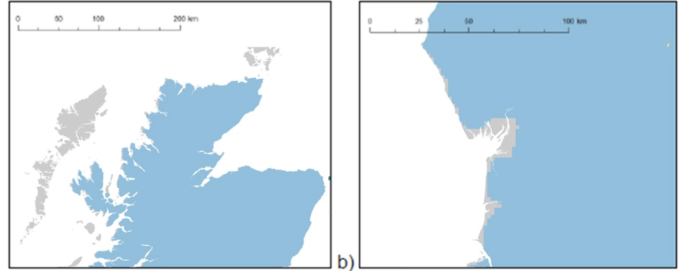
GeoClimate shrink-swell of a) the Outer Hebrides and b) Morecambe Bay, demonstrating the two origins of data unavailable areas (grey). BGS © UKRI 2026. Contains OS data © Crown copyright and database right (2026)
GeoClimate Shrink–Swell uses 1:50 000-scale geological data. It is therefore quasi- 1:50 000 scale and is intended for use at this scale. All spatial searches of the maps should be undertaken using a minimum 50 m buffer. This is because the smallest detectable feature at this scale is 50 m. Consequently, digital data should be used at about the same scale as the original compilation; for example, 1:50 000-scale data should not normally be used at the 1:10 000 scale.
Most geological maps were originally fitted to a particular topographical base and care must be taken in interpretation, for example when the geological data is draped over a more recent topography.
This dataset is not routinely updated; it is revised on an ad hoc basis, as and when there are significant changes in its source data or when it is prioritised for update.
This dataset is licenced from BGS. Please refer to the terms of your licence or contact BGS IPR (ipr@bgs.ac.uk) for further information.
Despite the aggressive mitigation described in RCP 2.6, warming is predicted to continue and peak mid-century, then gradually decline and stabilise. Even with immediate, sustained and very rapid reductions in GHG emissions globally, UKCP18 suggests the country will experience an additional warming of around 0.6°C between now and 2050 (Climate Change Committee, [year]). RCP 2.6 projects long-term stabilisation occurring by 2070, with recovery towards wetter conditions.
Due to there being relatively modest differences between the emissions for the different RCPs at the start of the century and the atmospheric lags experienced, there is no simple, clear relationship between the RCPs for the 2030 projections. Due to the lag between CO2 emission reductions and climate response (decades), these only start to have a clearer impact after the 2050s.
Burning of coal and other fossil fuels releases GHGs and sulfate aerosols. Sulfate aerosols have a cooling effect on the climate, by reflecting sunlight and promoting cloud formation, leading to less sunlight reaching the ground surface thus partially masking the warming effect of GHGs. Sulfates have a relatively short lifetime in the atmosphere (days to weeks) in comparison to CO2, of which around 50 per cent is absorbed within 30 years.
A very rapid decrease in coal use is projected for RCP 2.6 by 2020, leading to a swift reduction in GHG and sulfate emissions. The RCP 2.6 projection is dominated by the success of the reduction in GHG emissions and there is little additional impact from the reduction in sulfate aerosols. In comparison with the intermediate mitigation pathway RCP 4.5, the reduction in aerosols contributes to the warming projected for 2030 and the related increase in shrink–swell susceptibility. This is because, when production falls due to the shorter atmospheric lifetime of the sulfates, levels decrease quicker than those for CO2 and GHGs.
Just as RCP 2.6 is dominated by the impact of rapidly decreasing GHG emissions, RCP 8.5 is driven by the gradually increasing GHG emissions over the coming century, with the sulfates again playing a minor role. The near-term projections (2030) for GeoClimate shrink–swell for RCPs 4.5 and 8.5 are therefore not that dissimilar.
RCP 4.5 assumes GHG emissions peak around 2040 and then start to decline. Due to lags in atmospheric GHG concentrations, the trends of increasing summer temperatures, decreasing summer rainfall and increasing summer rainfall intensity persist until the end of century.
The GeoClimate methodology involves a hydrogeological model, which provides soil moisture deficit values at a 2 km grid resolution. Therefore, though the projected rainfall and temperature values are daily 1 km grid datasets, the output is a 2km grid, which is then combined with the 1:50000 geological data.
As there is the potential of low-resolution data being used inappropriately for site-specific or high-stakes decisions, when used outside its intended scale and limits and without a clear understanding of the methodology and input datasets, a corporate decision was made to withdraw future Open GeoClimate datasets.
BGS GeoClimate UKCP09 and BGS GeoClimate UKCP18 have now been withdrawn and superseded as BGS data products. As such the datasets are not actively maintained, although they are still scientifically correct and valid at the time that they were originally published. This BGS GeoClimate clay shrink-swell (CHESS-SCAPE) data product is being actively supported within the BGS portfolio of data products and utilises our most up to date climate projections, so we would encourage the use of this dataset.
You may also be interested in
BGS GeoSure: shrink–swell subsurface
This is a single data layer that identifies areas of potential shrink–swell hazard that are underneath another solid formation and therefore hidden from the surface.
GeoCoast Premium
GeoCoast is an integrated GIS package of datasets designed to inform and support coastal management and adaptation.