New seabed maps offer a window into the distant past
BGS has begun publishing a new series of high-resolution offshore geological maps showing the distribution of bedrock and sediments that make up the seabed around our coasts.
10/10/2022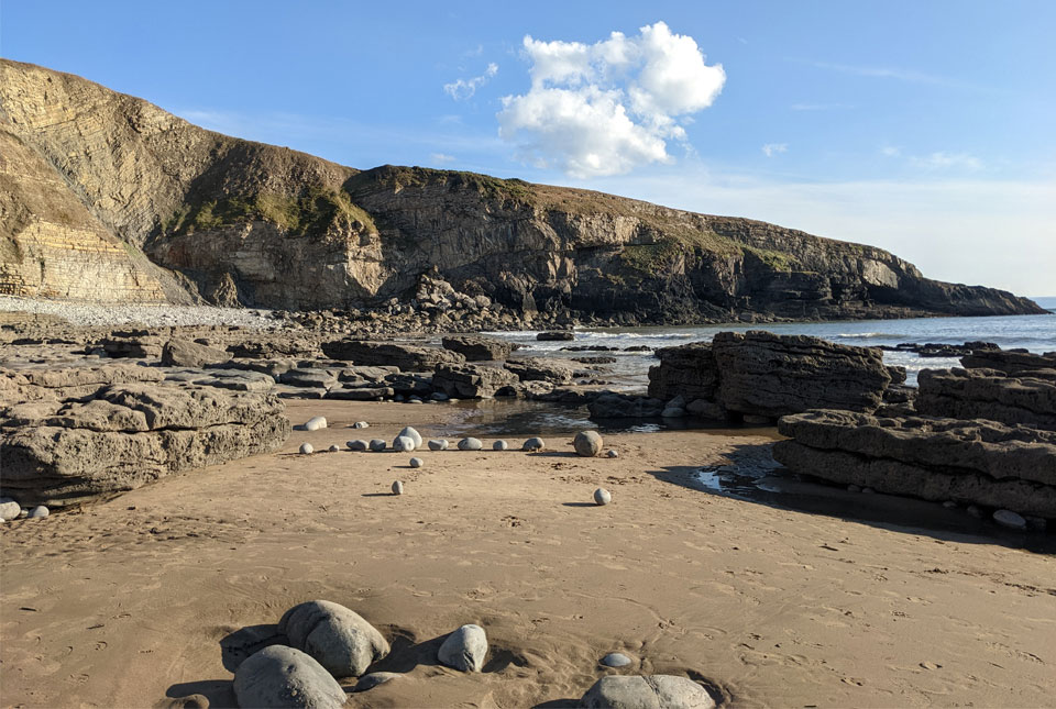

BGS has begun publishing a new series of high-resolution offshore geological maps showing the distribution of bedrock and sediments that make up the seabed around our coasts. Maps of the Bristol Channel and Anglesey were the first to be published, with further regions such as Yorkshire and East Anglia to follow as our mapping programme progresses.
This article takes a closer look at the seabed featured in the the first map of the series, which stretches along the central part of the Bristol Channel, from south of Swansea Bay in the west to Newport in the east.
The Bristol Channel
The Bristol Channel is a large estuary and river system that extends from the Celtic Sea eastwards to the limit of tidal influence along the River Severn at Gloucester. The channel separates South Wales from Devon and Somerset and has the second-largest tidal range in the world at Avonmouth, with a 12.3 m mean spring range (SouthWalesPorts.co.uk).
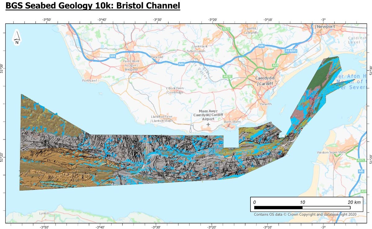
Figure 1: Extent of the Bristol Channel. Contains OS data © Crown Copyright and database right 2020.
The derived bathymetric layer was produced from Maritime and Coastguard Agency (MCA) data © Crown Copyright. Not to be used for navigational purposes.
Bedrock geology
The seabed of the Bristol Channel is partially covered by soft sediments (superficial deposits) but much of the area is free of sediment cover, allowing for the detailed mapping and interpretation of bedrock units and features. The bedrock geology recognisable in the bathymetric data will be familiar to anyone who knows the coastline of south-east Wales, which is characterised by low, Carboniferous limestone cliffs surrounded by younger, Triassic- and Jurassic-aged rocks.
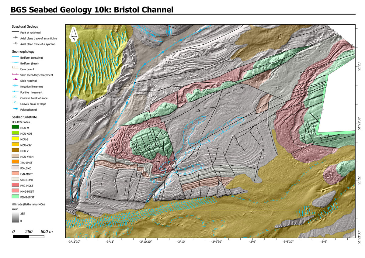
Figure 2a. Inliers of fractured Carboniferous limestone and surrounded and overlain by Mesozoic rocks – shows interpreted geology displayed on the bathymetric data.
The derived bathymetric layer was produced from Maritime and Coastguard Agency (MCA) data © Crown copyright. Not to be used for navigational purposes
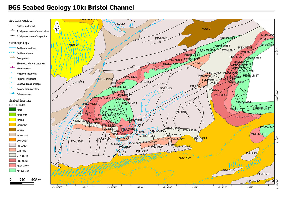
Figure 2b. Inliers of fractured Carboniferous limestone and surrounded and overlain by Mesozoic rocks – without background information.
The bedrock geology presented on the new maps shows a pattern of small outcrops of highly fractured Carboniferous rocks of the Pembroke Limestone Group, which would have formed a landscape of hills and valleys following uplift and erosion caused by the Variscan Orogeny.
A window into the distant past
During the Triassic, this part of Wales was hot and arid with wadis, flash flooding and scree slopes (Mercia Mudstone Marginal Facies) surrounding the hills and cliffs. The low ground in between featured lakes that deposited mudstones and periodically evaporated to leave salt flats (the ‘red beds’ of the Mercia Mudstone Group). These deposits sit unconformably on the Lower Palaeozoic landscape.
During the late Triassic and Lower Jurassic, a marine transgression, or rise in sea level, flooded the landscape. A series of deposits recording this event can be seen in the cliffs of the Vale of Glamorgan and traced off shore (Penarth Group). By the Jurassic, this part of Wales had become marine and units of the Lias Group were deposited, including the, which is divided into the St Marys Well Bay, Lavernock Shales and Porthkerry members. The youngest bedrock unit identified is the Inferior Oolite Group, which records deposition in a shallow, sea-shelf environment.
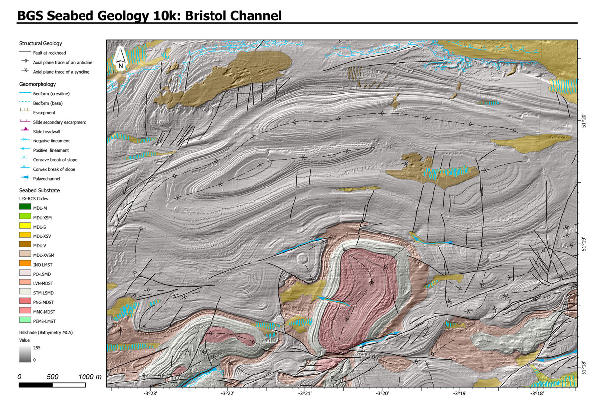
Figure 3. Cycles of limestone and calcareous mudstone of the Porthkerry member showing striking resemblance to the cliffs at Dunraven Bay. Geological interpretation is displayed on the bathymetric data.
The derived bathymetric layer was produced from Maritime and Coastguard Agency (MCA) data © Crown copyright. Not to be used for navigational purposes.
All of these rocks were subsequently deformed, most likely by the Alpine Orogeny. This was a period of mountain building in central and southern Europe and west Asia. The orogeny resulted in a network of folds, fractures and faults that is especially apparent in the deformation and offsetting of the rocks in the well-bedded Porthkerry Member and Inferior Oolite Group.
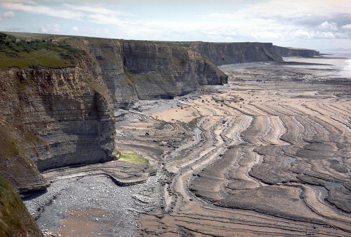
Figure 4. View from Dunraven Castle, south east across Dunraven Bay, north coast of Bristol Channel, Vale of Glamorgan. BGS © UKRI
Geological structure
The north-east to south-west orientation of the inner part of the Bristol Channel (which is included in the eastern part of our new dataset) and much of the Severn Estuary is influenced by the Severn Estuary fault zone. This is a dextral, strike-slip fault zone considered to have been active during the early Carboniferous. Comparable north-east to south-west trending faults have been recognised within the eastern part of the area covered by this dataset, where they dissect earlier-formed folds and offset the bedding within the Porthkerry Member.
However, within the central and outer parts of the Bristol Channel, the faults are dominated by:
- a set of west-north-west to east-south-east trending structures
- a locally complex network of north-north-west to south-south-east and north-north-east to south-south-west trending cross-faults
These structures have been digitised as ‘fault observed, displacement unknown’ due to the potential complexity and multiple phases of movement over time. There is also an absence of clear marker horizons or beds within, in particular, the Porthkerry Member.
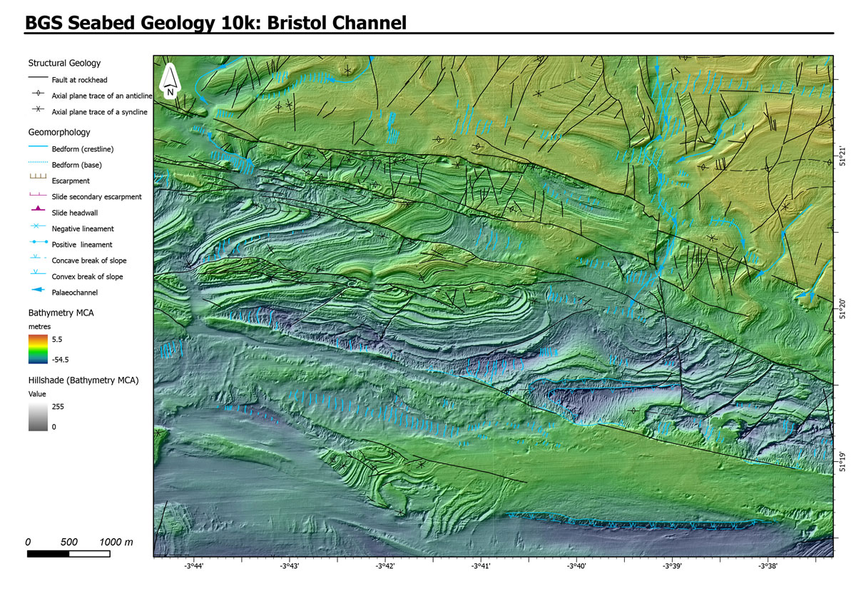
Figure 5. Example of fracture patterns mapped in the south-west area of the map. Fractures are displayed here overlaying the bathymetric data.
The derived bathymetric layer was produced from Maritime and Coastguard Agency (MCA) data © Crown copyright. Not to be used for navigational purposes
The east to west trending faults are interpreted as forming part of the central Bristol Channel fault zone, a major fault system that is believed to have developed in response to the extensional reactivation of an underlying Variscan thrust during the Mesozoic. North-west to south-east trending faults within the Bristol Channel, including the Sticklepath–Lustleigh and Watchet (also known as Cothelstone) faults, are interpreted as older Variscan structures that reactivated in response to tectonic events during the Mesozoic and Cenozoic.
Superficial deposits
The superficial sediments identified within the dataset comprise marine deposits that include:
- gravel
- sand
- mud
- sandy mud
- sand and gravel
- mud, sand and gravel
The deposits of sand and gravel within the central part of the dataset are related to areas of potentially mobile sediment within the Bristol Channel. A range of bedforms associated with recent or contemporary marine processes within a tidal-dominated environment has developed upon these superficial sediments.
Linear, ribbon-like areas of sand-and-gravel are located along a marked channel incised into the bedrock, which denotes the course of the palaeo-River Severn and its tributaries. Smaller areas of sand occur to the north and south of this palaeo-river channel, where they occur on relatively flat to very gently dipping areas of bedrock, in particular in the area underlain by the well-bedded limestone and mudstone sequence of the Porthkerry Member.
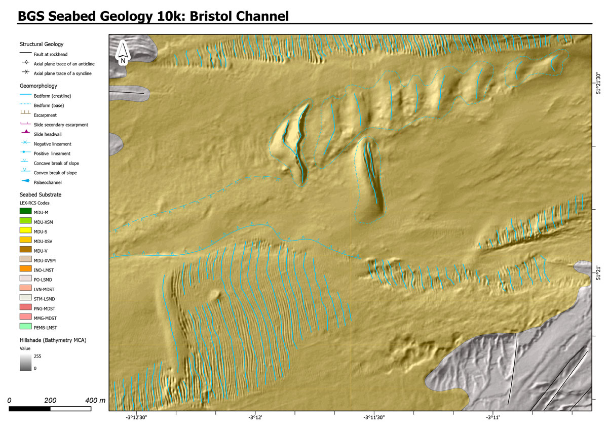
Figure 6a. Typical areas of superficial deposits captured in the new detailed geology – mobile sediments in the form of dunes and ripples.
The derived bathymetric layer was produced from Maritime and Coastguard Agency (MCA) data © Crown copyright. Not to be used for navigational purposes.
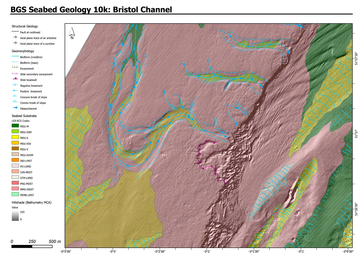
Figure 6b. Typical areas of superficial deposits captured in the new detailed geology – palaeo-channels cut into rocks of the Mercia Mudstone Group and infilled with modern sediments.
The derived bathymetric layer was produced from Maritime and Coastguard Agency (MCA) data © Crown copyright. Not to be used for navigational purposes.
In some areas, the sediment cover is relatively thin and the bedrock geology can be clearly seen or traced through these superficial deposits, or the superficial deposits are too thin to be clearly represented on a geological map designed to be viewed at the 1:10 000 scale. Consequently, only the more prominent, thicker superficial deposits have been captured (digitised) within the dataset, to provide the user with an indication of the main areas of potentially mobile sediment.
The superficial sediment cover at the eastern end of the mapped area is typically finer grained (mud and sand), reflecting its location within the inner part of the Bristol Channel.
An area of gravel and sand-and-gravel exposed at the north-western end of the dataset may represent a submerged, shallow, coastal sequence, with the sands and gravels infilling an irregular network of tidal channels. The coarse-grained nature of these deposits may, at least in part, result from the subsequent removal (winnowing) of fines (mud) by tidal currents within the high-energy environment of the central Bristol Channel.
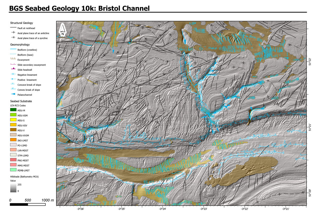
Figure 7. Extract from the central part of the map illustrating a range of linear features. These include fractures, faults and folds in the bedrock and crests of dunes and ripples, terrace margins and palaeo-channels.
The derived bathymetric layer was produced from Maritime and Coastguard Agency (MCA) data © Crown copyright. Not to be used for navigational purposes
The modern channel
The present-day geomorphology of the seabed across the Bristol Channel is influenced by events that occurred throughout the Quaternary. Evidence of fluvial processes is found in the form of the palaeo-River Severn channel and its tributaries. These palaeo-channels are incised into the bedrock in the central and inner parts of the Bristol Channel, with their margins denoted by marked breaks in slope (both convex and concave).
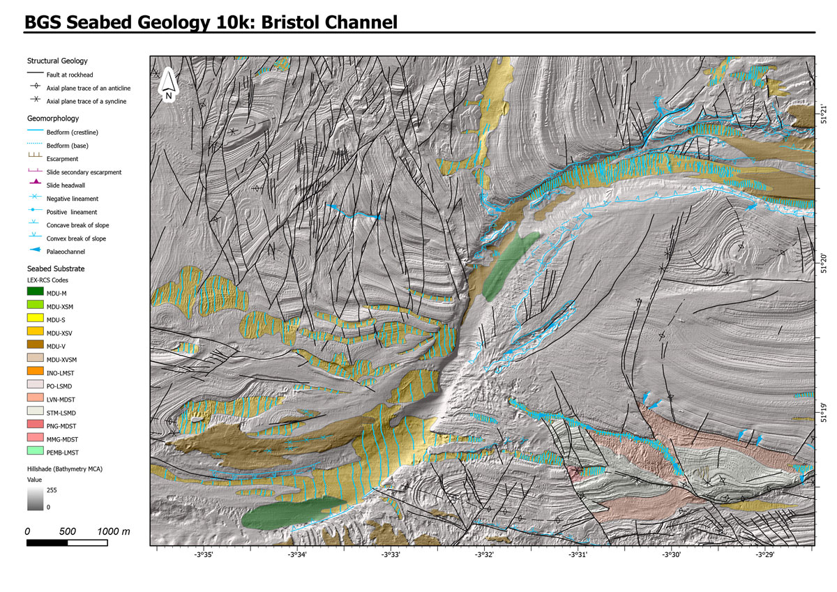
Figure 8a. The Palaeo-River Severn cut down into bedrock in the central part of the map with geological interpretation of features superimposed – including the bathymetric data.
The derived bathymetric layer was produced from Maritime and Coastguard Agency (MCA) data © Crown copyright. Not to be used for navigational purposes

Figure 8b. The Palaeo-River Severn cut down into bedrock in the central part of the map with geological interpretation of features superimposed – without the bathymetric data.
The derived bathymetric layer was produced from Maritime and Coastguard Agency (MCA) data © Crown copyright. Not to be used for navigational purposes
The floors of the larger channels are locally covered by sand and/or gravel, with well-developed bedforms on the surface of these superficial deposits. The predominantly north-to-south trend of the crestlines of the sand waves is consistent with the superficial deposits being variably reworked by tidal currents flowing parallel to the central axis of the Bristol Channel.
Breaks of slope within the largest channel marking the main course of the palaeo-River Severn are considered to mark the variably degraded edges of former river terraces. Elsewhere, the surface of the superficial sediments and bedrock is relatively smooth or incised by long, linear, positive and negative features formed as a result of scouring of the seabed by strong bottom currents.
Accessing the data
These maps are available from BGS under the fine-scale maps section of the Offshore GeoIndex and are designed to be viewed at 1:10 000 scale.
Downloadable data is also available via a commercial data licence, but fee-free for academic research, use by registered charities, or in connection with emergency or civil contingency incidents.
For details please contact iprdigital@bgs.ac.uk.

Rhian Kendall
BGS Chief Geologist, Wales
Relative topics
Related news

Geological research in North Sea helping to safeguard subsea cables
06/07/2026
Subsea power and telecommunications cables are critical to the UK’s energy infrastructure and global connectivity, yet they remain vulnerable to damage from ship anchors, fishing activity and natural hazards.

UK scientists unite for seabed mapping survey of the UK’s south-west coastline
15/04/2026
BGS geologists join research voyage, gathering crucial geological data to support offshore energy and infrastructure projects.

Updated geological assessment of the Southern North Sea set to underpin future offshore infrastructure development
25/03/2026
The first regional assessment for 30 years will support offshore marine and subsurface planning for the UK’s low-carbon energy infrastructure, including the 2030 target of 45 to 50 GW generated through offshore wind.

Extensive freshened water confirmed beneath the ocean floor off the coast of New England for the first time
09/02/2026
BGS is part of the international team that has discovered the first detailed evidence of long-suspected, hidden, freshwater aquifers.

Quaternary UK offshore data digitised for the first time
21/01/2026
The offshore wind industry will be boosted by the digitisation of a dataset showing the Quaternary geology at the seabed and the UK’s shallow subsurface.

Offshore Quaternary 250K
The 1:250 000-scale offshore geological map for quaternary geology (BGS Geology: marine quaternary 250k) is available digitally.

How the geology on our doorstep can help inform offshore infrastructure design
19/11/2025
BGS is part of a new collaboration using onshore field work to contextualise offshore data and update baseline geological models which can inform the sustainable use of marine resources.

Extended seabed geology map of the Bristol Channel published
07/10/2025
BGS has released significantly extended high-resolution maps that will support offshore green-energy initiatives in the area.

New seabed sediment maps reveal what lies beneath the waves
03/09/2025
Marine ecosystem science and offshore infrastructure will be boosted by a new dataset showing sediment composition across the UK continental shelf.

Seabed sediments 250K
This offshore Quaternary geology dataset shows the distribution of interpreted lithostratigraphical units within the shallow subsurface. The dataset represents the Quaternary geology immediately beneath the active seabed sediment layer.

Offshore bedrock 250K
The BGS Offshore Bedrock 250k dataset depicts the distribution of the different types of bedrock on the UK Continental Shelf.

IODP³-NSF Expedition 501: successful offshore operations launches onshore phase
06/08/2025
Scientists have managed to take water and sediment samples from beneath the ocean on the New England Shelf for the first time, with the intention of understanding this offshore aquifer system.