New geological map of offshore Anglesey released
BGS has released a new fine-scale digital map featuring the seabed geology of offshore Anglesey (Ynys Môn).
10/10/2022 By BGS Press

Anglesey (Welsh: Ynys Môn) follows the Bristol Channel as the second in a series of new fine-scale maps that contain combined bedrock, sediment, bedrock structure and seabed geomorphology data.
The maps are based on data produced by UK Civil Hydrography Programme of the Maritime and Coastguard Agency, which includes bathymetry data, backscatter imagery, grab samples and other existing datasets such as seismic, sediment texture sheets and existing 1:250 000-scale geological maps.
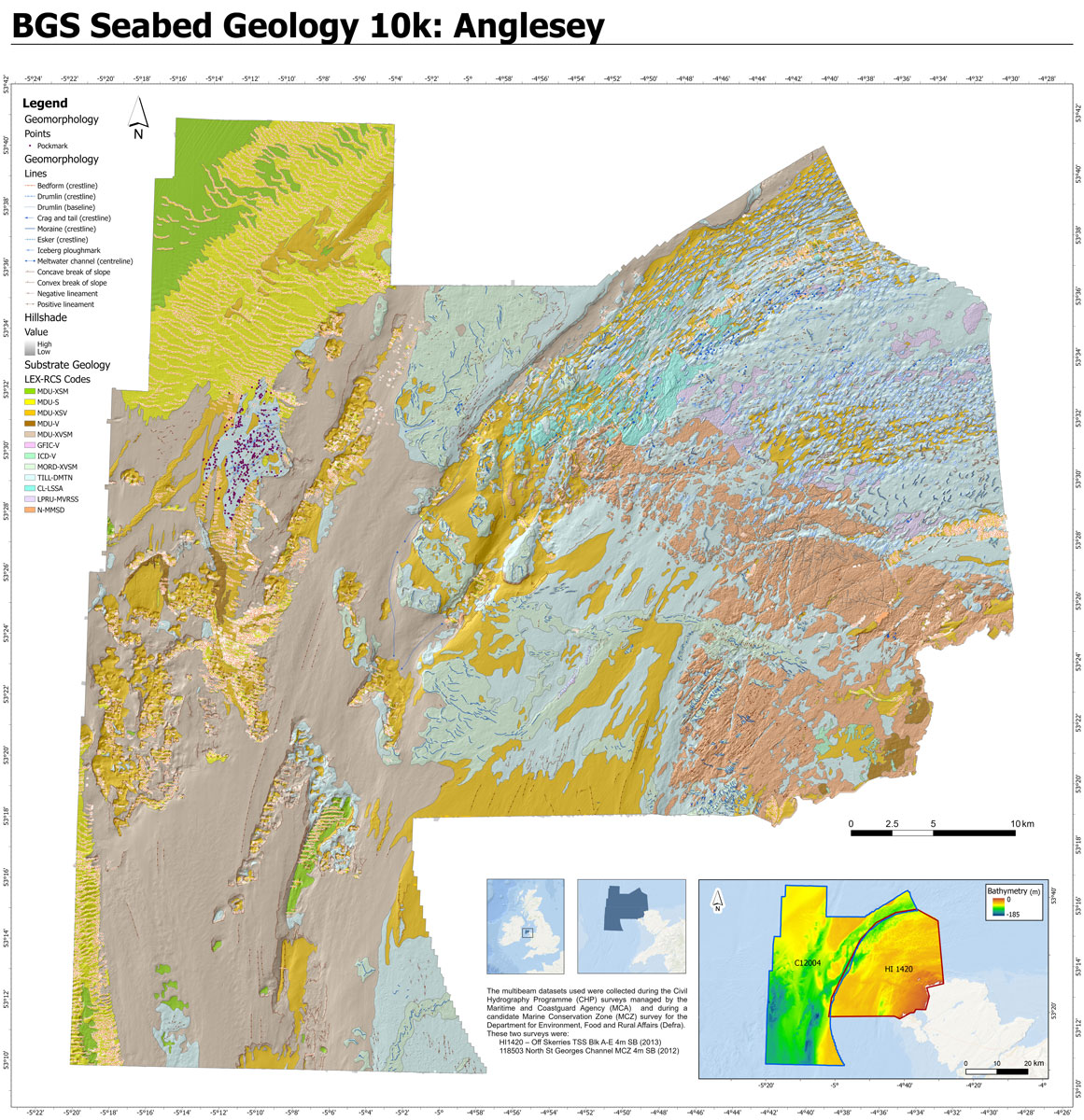
Extent of the new Anglesey seabed geology map. Contains data acquired by the MCA and by Defra © Crown Copyright 2022. Not to be used for navigational purposes
These new resources provide important evidence for policy and decision makers, who need to consider the increasing demands being placed on the marine environment from recreation, marine conservation and protection, fishing and resources (e.g. aggregates). The data may be of particular interest to developers of tidal stream energy devices wanting to deploy technology and infrastructure to create renewable energy and generate clean, low-carbon electricity, making Anglesey a hub for marine energy.
Priority areas currently being mapped also include Yorkshire and East Anglia, with other areas being added as our fine-scale mapping programme progresses.
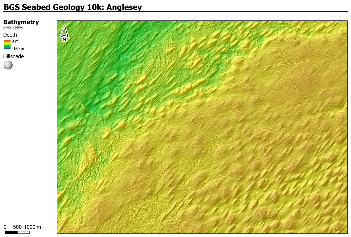
Seafloor bathymetry. Bathymetry data acquired by MCA © Crown Copyright 2022. Not to be used for navigational purposes.
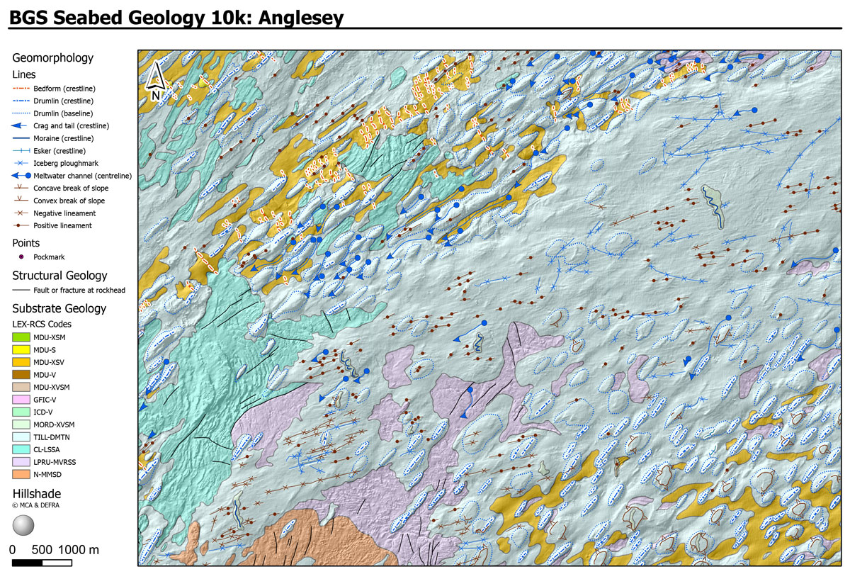
Extract from the BGS Anglesey seabed geology map. BGS © UKRI.
The seabed substrate around Anglesey forms a fascinating patchwork of bedrock, glacial deposits and more recent marine sediments. Remarkably well-preserved suites of drumlins can be seen on the sea floor in this area; these were moulded under the last ice sheet as it flowed towards the south-west. When the glacier margin retreated, icebergs began to break off, ploughing grooves that can now be seen on the seabed. Under modern marine conditions, strong currents have produced sand waves that can migrate across parts of the sea floor.
The maps are available from BGS under the fine-scale maps section of the Offshore GeoIndex and are designed to be viewed at 1:10 000 scale or offline as downloadable shapefiles.
Other maps in this series:
Relative topics
Related news

Geological research in North Sea helping to safeguard subsea cables
06/07/2026
Subsea power and telecommunications cables are critical to the UK’s energy infrastructure and global connectivity, yet they remain vulnerable to damage from ship anchors, fishing activity and natural hazards.

UK scientists unite for seabed mapping survey of the UK’s south-west coastline
15/04/2026
BGS geologists join research voyage, gathering crucial geological data to support offshore energy and infrastructure projects.

Updated geological assessment of the Southern North Sea set to underpin future offshore infrastructure development
25/03/2026
The first regional assessment for 30 years will support offshore marine and subsurface planning for the UK’s low-carbon energy infrastructure, including the 2030 target of 45 to 50 GW generated through offshore wind.

Extensive freshened water confirmed beneath the ocean floor off the coast of New England for the first time
09/02/2026
BGS is part of the international team that has discovered the first detailed evidence of long-suspected, hidden, freshwater aquifers.

Quaternary UK offshore data digitised for the first time
21/01/2026
The offshore wind industry will be boosted by the digitisation of a dataset showing the Quaternary geology at the seabed and the UK’s shallow subsurface.

Offshore Quaternary 250K
The 1:250 000-scale offshore geological map for quaternary geology (BGS Geology: marine quaternary 250k) is available digitally.

How the geology on our doorstep can help inform offshore infrastructure design
19/11/2025
BGS is part of a new collaboration using onshore field work to contextualise offshore data and update baseline geological models which can inform the sustainable use of marine resources.

Extended seabed geology map of the Bristol Channel published
07/10/2025
BGS has released significantly extended high-resolution maps that will support offshore green-energy initiatives in the area.

New seabed sediment maps reveal what lies beneath the waves
03/09/2025
Marine ecosystem science and offshore infrastructure will be boosted by a new dataset showing sediment composition across the UK continental shelf.

Seabed sediments 250K
This offshore Quaternary geology dataset shows the distribution of interpreted lithostratigraphical units within the shallow subsurface. The dataset represents the Quaternary geology immediately beneath the active seabed sediment layer.

Offshore bedrock 250K
The BGS Offshore Bedrock 250k dataset depicts the distribution of the different types of bedrock on the UK Continental Shelf.

IODP³-NSF Expedition 501: successful offshore operations launches onshore phase
06/08/2025
Scientists have managed to take water and sediment samples from beneath the ocean on the New England Shelf for the first time, with the intention of understanding this offshore aquifer system.