BGS releases first in a series of new offshore maps of the UK seabed
BGS has released the first high-resolution, offshore map in a new series featuring the seabed around the UK.
06/04/2022 By BGS Press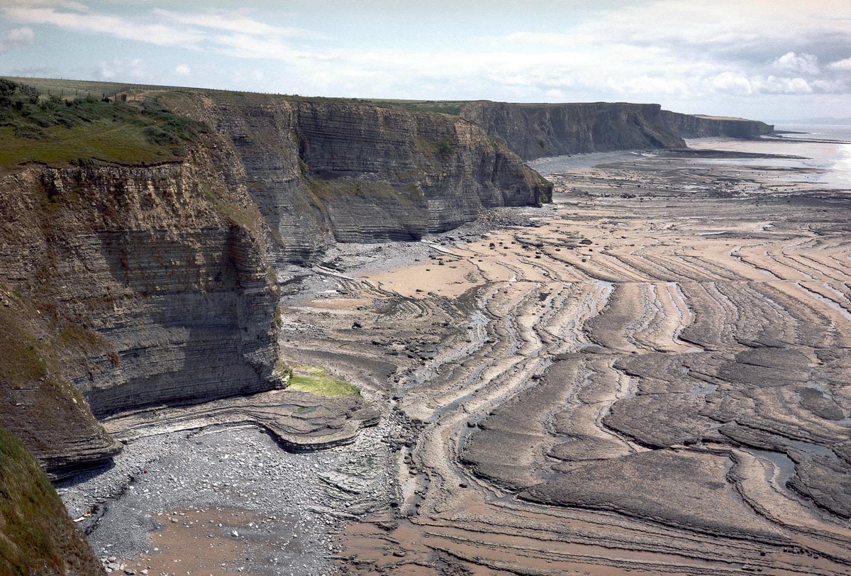

New combined bedrock, sediment, bedrock structure and seabed geomorphology maps are available from BGS under the fine-scale maps section of the Offshore GeoIndex and are designed to be viewed at 1:10 000 scale or online as downloadable shapefiles.
Based primarily on data produced by UK Civil Hydrography Programme of the Maritime and Coastguard Agency and made available by the UK Hydrographic Office, they are of relevance to offshore developers who require a detailed understanding of the geology of the seabed. The maps include bathymetry data, backscatter imagery, grab samples and other existing datasets such as seismic, marine conservation zones, sediment texture sheets and existing 1:250 000-scale geological maps.
As the UK’s transition to renewable energy gathers pace, these maps will become increasingly valuable to industry and stakeholders with an interest in developing clean energy, from offshore wind to tidal streaming, and in carbon capture and storage.
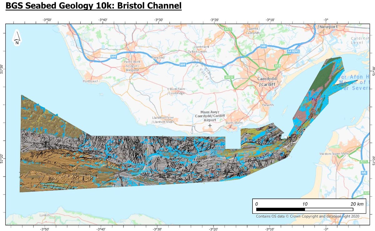
Extent of the new Bristol Channel map. Contains OS data © Crown Copyright and database right 2020. The derived bathymetric layer was produced from Maritime and Coastguard Agency (MCA) data © Crown copyright. Not to be used for navigational purposes.
The first area to be published this month features a central section of the Bristol Channel, from Swansea Bay to Newport, which is home to the second largest tidal range in the world. The high-energy environment of the channel has attracted much interest in recent years for the use of the seabed for tidal power schemes, including tidal power schemes that have the potential to produce electricity from wave energy.

Adopting renewable energy and technologies requires a deep understanding of the seabed and so developers have a growing need for access to bathymetric data, enabling more detailed observations of seabed geomorphology that are central to such evaluations.
As well as being of use to offshore developers, the release of our new maps will benefit all kinds of applications: marine spatial planning, technological research and development, fishery resource management, environmental impact studies and climate change models, providing evidence for policy and decision makers.
Prof Emrys Phillips, BGS Quaternary and Glacial Scientist.
While mapping the seabed has been a major challenge for marine geoscientists over the years, the development in acoustic technologies has allowed for the collection of more, and much better resolution, data in much less time.
BGS has plans to release a suite of high-resolution maps in the future, including offshore Anglesey, Yorkshire and East Anglia, and further areas will be added to BGS GeoIndex Offshore as its marine mapping programme progresses.
This is a great example of using the excellent high quality freely available data collected under the CHP for a different reason from its original purpose and gaining extra geological insights and value from the data.
Mary Mowat, BGS Marine Data Manager
Relative topics
Related news

New NERC-funded project empowers young people to engage with environmental science
23/07/2026
BGS is part of a new, collaborative project, funded through NERC’s ‘Opening up the environment’ programme, helping the environmental research community become more accessible.

Delving deep into mountains for future water security
16/07/2026
A BGS-led project is using new water-tracing investigation methods, geophysics and modelling to understand how water moves from mountains to the lowlands, helping to improve water security for billions of people.

Updated national 3D model will determine the depth to the solid bedrock beneath our feet
13/07/2026
The BGS Superficial Deposit Thickness Model now includes an elevation model of geological rockhead for the first time, providing important data for civil engineers, geoscientists and environmental scientists.

UK’s world-class research organisations launch new collective
10/07/2026
The launch of the National Research Organisations Group brings together more than 100 science leaders to provide an authorativive voice on science, research policy and long-term investment.

Cheshire Geoenergy Observatory releases key geological datasets for UK thermal energy storage scheme design
09/07/2026
A new report and data packs from BGS will provide a unique resource for scientists working on the geology and hydrogeology of the Sherwood Sandstone Formation, an important aquifer and reservoir rock.

New geological mapping underway to help manage flooding along the River Tweed
08/07/2026
Scientists are surveying the Tweed catchment for the first time in over 100 years to enhance understanding of localised groundwater and improve flood forecasting.

Geological research in North Sea helping to safeguard subsea cables
06/07/2026
Subsea power and telecommunications cables are critical to the UK’s energy infrastructure and global connectivity, yet they remain vulnerable to damage from ship anchors, fishing activity and natural hazards.

UK Critical Minerals Intelligence Centre makes recommendations for the next UK criticality assessment
01/07/2026
CMIC has outlined the enhancements made to the next assessment update to ensure it is better tailored to the structure of the UK economy.

From archive to discovery: historical mineral reports support gold exploration in Scotland
25/06/2026
Digitised geological records show potential to unlock untapped mineral resources in Ardlochan, Argyllshire.

UK and Philippines scientists investigate natural hydrogen generation processes at atomic scale
22/06/2026
BGS researchers were granted access to use the Diamond Light Source facility in order to study hydrogen in light brighter than the sun.

Shortage of end-of-life materials presents challenge to UK critical minerals security
17/06/2026
A new report by the UK Critical Minerals Intelligence Centre reveals insufficient end-of-life material stocks present a supply risk over the coming decade, but offer significant long-term potential to meet critical mineral demand through recycling.

UK geothermal catalogue receives update
16/06/2026
BGS releases the second digital version of the UK geothermal catalogue of subsurface temperature and rock thermal conductivity measurements and heat flow calculations.