Scientists reveal extraordinary ecosystems in the deepest part of the Indian Ocean
New technology has enabled marine scientists to capture some of the world’s first images of previously unexplored habitats in the deepest point of the Indian Ocean.
08/06/2022 By BGS Press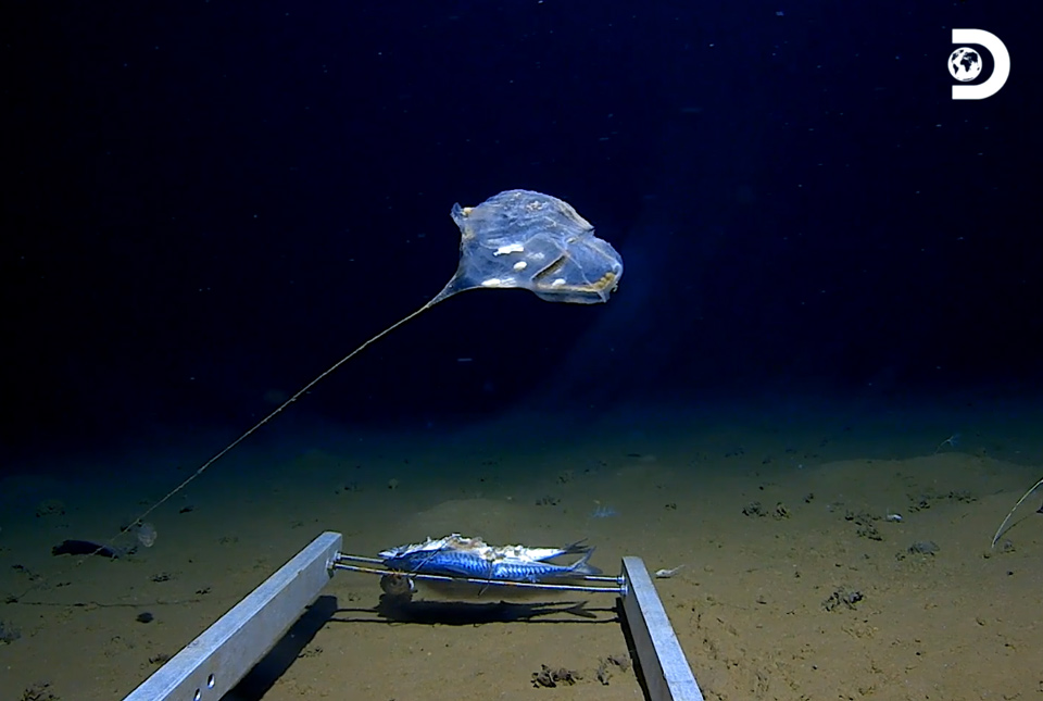

Marine scientists have long acknowledged the global importance of understanding deep-sea hadal biodiversity for habitat management. So far, however, efforts have been largely focused on shallower waters, typically in the upper 5000 m of the ocean.
In April 2019, the record-breaking Five Deeps Expedition provided a rare and exciting opportunity to apply state-of-the-art technology to observe the biodiversity and geodiversity of these deep-sea environments. A team of marine researchers, led by Alan Jamieson of Newcastle University, made the first crewed descent to the bottom of the Java Trench (also known as the Sunda Trench) – an arc-shaped, deep ocean trench some 3200 km long located in the eastern Indian Ocean, south and west of the islands of Sumatra and Java.
The world’s first — and only — fully certified crewed vessel capable of diving to full ocean depth, the DSV Limiting Factor acquired a video transect from the deepest point of the trench up a near-vertical escarpment in waters more than 7000 m deep. The team, which includes marine researchers from BGS and Newcastle University, recently confirmed their extraordinary discoveries in an open-access paper published in Frontiers in Marine Science.

Applying new technology to the largely unexplored depths of the Indian Ocean produced an extraordinary set of rare and unique discoveries in just five days.
The Java Trench is largely unexplored and it was a unique opportunity to be able to freely explore such complex terrain and observe the distribution of biological species and geological formations that make up these habitats.
Heather Stewart, BGS Marine Geologist.
One of the least understood of the world’s five oceans, the Indian Ocean is the third largest, spanning 70.56 million km2 and accounts for 19.8 per cent of the global ocean volume.
The complex sea-floor geomorphology of the Indian Ocean hosts subduction trenches, seamounts, ridges, plateaux, coral atolls and fracture zones. Despite a wealth of research into the coastal marine biodiversity of the ocean, few previous research expeditions have explored water depths exceeding 5000 m, leading to a significant knowledge gap.
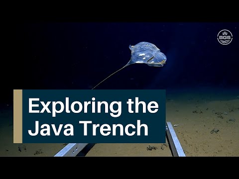

Exploring the Java Trench. Footage courtesy of and © Atlantic Productions.
At 7192 m depth (more than five times the height of Ben Nevis) the team managed to capture some incredible footage of what are thought to be entirely new species from the deepest point of the trench, using the submersible and fleet of autonomous scientific landers. During the five-day expedition they observed new species of hadal snailfish as well as an extraordinary-looking animal believed to be a stalked ascidian, otherwise known as a sea squirt, that by luck drifted past the video camera. The first hadal octopodes were found as well as the deepest larvaceans and decapods were also observed.
Researchers steered the submersible from the soft-sedimented trench axis up a 150 m-high, near-vertical escarpment and across a plateau at a depth of around 7050 m. The exposed rock face of the escarpment hosted areas of debris formed by structural weaknesses in the bedrock eventually failing leaving piles of debris at the base of steep sections. Orange, yellow and white colours pick out these bedrock fractures in a spectacular display of chemosynthetic bacterial communities that live off fluids oozing from the cracks in the rock face.
Ideally we would return and do many more submersible surveys to explore a greater area of sea floor on a variety of geomorphological and geological features. We could then assess how common these chemosynthetic communities are and figure out how important a role they play in the food web at these extreme depths.
Heather Stewart.
We’re very excited by the potential for more studies. Research like this will help to steer the first steps towards more hypothesis-driven and less exploratory-driven science at full ocean depth.
Eventually, this will bridge the gap between this type of observational research and the early taxonomic work completed in the 1950s, to lift the quality of research from the deep water hadal zones closer to that of its shallower counterparts.
Alan Jamieson, Newcastle University senior lecturer.
Relative topics
Related news

Geological research in North Sea helping to safeguard subsea cables
06/07/2026
Subsea power and telecommunications cables are critical to the UK’s energy infrastructure and global connectivity, yet they remain vulnerable to damage from ship anchors, fishing activity and natural hazards.

UK scientists unite for seabed mapping survey of the UK’s south-west coastline
15/04/2026
BGS geologists join research voyage, gathering crucial geological data to support offshore energy and infrastructure projects.

Updated geological assessment of the Southern North Sea set to underpin future offshore infrastructure development
25/03/2026
The first regional assessment for 30 years will support offshore marine and subsurface planning for the UK’s low-carbon energy infrastructure, including the 2030 target of 45 to 50 GW generated through offshore wind.

Extensive freshened water confirmed beneath the ocean floor off the coast of New England for the first time
09/02/2026
BGS is part of the international team that has discovered the first detailed evidence of long-suspected, hidden, freshwater aquifers.

Quaternary UK offshore data digitised for the first time
21/01/2026
The offshore wind industry will be boosted by the digitisation of a dataset showing the Quaternary geology at the seabed and the UK’s shallow subsurface.

Offshore Quaternary 250K
The 1:250 000-scale offshore geological map for quaternary geology (BGS Geology: marine quaternary 250k) is available digitally.

How the geology on our doorstep can help inform offshore infrastructure design
19/11/2025
BGS is part of a new collaboration using onshore field work to contextualise offshore data and update baseline geological models which can inform the sustainable use of marine resources.

Extended seabed geology map of the Bristol Channel published
07/10/2025
BGS has released significantly extended high-resolution maps that will support offshore green-energy initiatives in the area.

New seabed sediment maps reveal what lies beneath the waves
03/09/2025
Marine ecosystem science and offshore infrastructure will be boosted by a new dataset showing sediment composition across the UK continental shelf.

Seabed sediments 250K
This offshore Quaternary geology dataset shows the distribution of interpreted lithostratigraphical units within the shallow subsurface. The dataset represents the Quaternary geology immediately beneath the active seabed sediment layer.

Offshore bedrock 250K
The BGS Offshore Bedrock 250k dataset depicts the distribution of the different types of bedrock on the UK Continental Shelf.

IODP³-NSF Expedition 501: successful offshore operations launches onshore phase
06/08/2025
Scientists have managed to take water and sediment samples from beneath the ocean on the New England Shelf for the first time, with the intention of understanding this offshore aquifer system.