BGS scientists join international expedition off the coast of New England
Latest IODP research project investigates freshened water under the ocean floor.
20/05/2025 By BGS Press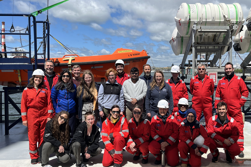

In the 1960s, scientists were quite surprised when they looked at their data: it clearly showed that there was fresh or freshened water under the ocean floor. How did it get there? How long has it been there? Scientists have been trying to find answers to these questions since their intriguing discovery.
Starting in May 2025, an international team of scientists will embark on an expedition to take a closer look at and take samples from this freshened water stored beneath the ocean floor. Prof Karen Johannesson of University of Massachusetts Boston and Prof Brandon Dugan of Colorado School of Mines are the co-chief scientists of this international expedition. Samples will be collected using the lift boat L/B Robert, which departed from the port of Bridgeport, Connecticut, USA, on May 19.
Seventy per cent of the Earth’s surface is covered with water, but water also flows beneath its surface. Most coastal communities rely on traditional onshore aquifers for fresh water; however, in many locations worldwide, onshore aquifers may have an offshore component where freshened water exists under the ocean floor. Even though the existence of these waters has been known for decades, they remain virtually unexplored. This will change through the groundbreaking research to be completed during this expedition, which is a collaboration between the International Ocean Drilling Programme (IODP³) and the US National Science Foundation (NSF). For the first time, scientists on IODP³-NSF Expedition 501 ‘New England Shelf hydrogeology’ will take water and sediment samples from beneath the ocean on the New England Shelf with the intention of understanding this offshore aquifer system.
Aim: validate hypotheses about water origin
The key priority for researchers is to gain more knowledge about the origin of freshened groundwater in offshore aquifers so that they can confirm or dismiss existing hypotheses. For example, current hypotheses are that the water could have charged the aquifers at a time when sea level was 100 m lower than it is today, or perhaps it was generated under an ice sheet or pro-glacial lake during a glacial period such as existed approximately 450 000 and approximately 20 000 years ago.

We have anecdotal evidence of offshore freshened groundwater from samples and marine geophysical surveys. We have used this evidence to develop hypotheses on timing and mechanism of emplacement. It is exciting to use established scientific ocean drilling approaches with modern data analyses to provide direct tests of our hypotheses. Overall, this work offshore New England will help us better understand offshore freshened groundwater around the world.
Prof Brandon Dugan, hydrogeologist, Colorado School of Mines.
To date, we know very little about the dynamics of these shoreline-crossing groundwater systems and the age of the water in these systems, and even less about their influence on cycling of nutrients and trace elements and their isotopes.
Prof Karen Johannesson, environmental geochemist, University of Massachusetts Boston.
The expedition is managed and technically supported by the team at BGS. A special platform, the L/B Robert, equipped with a small drilling rig, will be used to access the sediments below the ocean floor at up to three locations on the New England Shelf offshore from the coast of Massachusetts, USA. The locations are in relatively shallow water and were identified through numerous preliminary geoscientific investigations. Sediment cores and water samples will be taken down to a maximum depth of 550 m below the ocean floor and will be examined by researchers from various disciplines drawn from across the international scientific community.
High societal relevance: to better understand aquifers around the world
The team believes that the data acquired will help to better understand the processes that lead to the emplacement of freshwater lenses in offshore coastal plain sediments and why this freshened water is present. The findings will be relevant for the hydrogeology of the New England Shelf and for multiple similar settings elsewhere around the world.
The research is essential for a better understanding of the biogeochemical and elemental cycles in the continental shelf environment and will support a focus on the protection and sustainable management of offshore freshwater systems.
Staff from BGS have critical roles in the expedition, including offshore operations management (Leonardo Barbosa; Graham Tulloch), offshore project management (Jeremy Everest; Margaret Stewart; Raushan Arnhardt), IT and data management (Mary Mowat; Alan Douglas; Julian Gray), and onshore project management and leadership (David McInroy). With the expedition’s extra focus on groundwater fieldwork, BGS is providing extra hydrogeology and geochemistry technical support (Chelsea Bambrick, Rachel Bell, Bentje Brauns, Jack Brickell, Rebecca Ní Chonchubhair, Antonio Ferreira, Alex Mulcahy, Kyle Walker-Verkuil).
The team is incredibly excited to be finally heading out to sea to begin field operations, after many years of planning with project partners. We hope to recover invaluable core material and groundwater samples to improve our understanding of the development of the New England Shelf and the freshened water reservoirs underlying it. Scientific ocean drilling is technically challenging, expensive and therefore infrequent, which makes it a privilege to be part of such a project. We have a reasonable idea of what to expect in our boreholes, but there’s always the chance of discovering something unexpected scientifically, and that’s what makes offshore fieldwork so exciting.
David McInroy, BGS project lead.
The expedition aims to find answers to the following questions:
- how old is the freshened groundwater and when was it emplaced?
- how much fresh water is there?
- how does the fresh water interact with sea water?
- what microbial communities are involved?
- what sources of carbon do microbes use?
- what is the general cycling of nutrients and energy in the shelf sediments?
- how might these fresh waters influence nutrient, carbon and metal concentrations in sea water?
International approach
Forty-one science team members from 13 nations (Australia, China, France, Germany, India, Italy, Japan, Netherlands, Portugal, Sweden, Switzerland, United Kingdom, USA) will take part in the expedition, which consists of two phases: offshore and onshore operations. Offshore operations will take place between May and early August 2025. The entire science team will meet for the onshore work at the Bremen Core Repository, at MARUM Center for Marine Environmental Sciences at the University of Bremen (Germany) in January 2026 to split, sample and analyse the sediment cores and interpret the data collected. The cores will be archived and made accessible for further scientific research for the scientific community after a one-year moratorium period following an onshore operations phase of the expedition. All expedition data will be open access and resulting outcomes published.
The expedition is conducted by the European Consortium for Ocean Research Drilling (ECORD) as part of the International Ocean Drilling Programme (IODP³), funded by IODP³ and NSF. IODP³ is a publicly funded international marine research program supported by 16 countries, which explores Earth’s history and dynamics recorded in sea-floor sediments and rocks and monitors subsea-floor environments. Through multiple platforms — a feature unique to IODP³ — scientists sample the deep biosphere and subsea-floor ocean, environmental change, processes and effects, and solid-Earth cycles and dynamics.
More information
- About the expedition
- Scientific prospectus
- About the international research collaboration
- About the European part of the programme
- Mission-specific platform expeditions
- Frequently asked questions
Relative topics
Related news

Updated geological assessment of the Southern North Sea set to underpin future offshore infrastructure development
25/03/2026
The first regional assessment for 30 years will support offshore marine and subsurface planning for the UK’s low-carbon energy infrastructure, including the 2030 target of 45 to 50 GW generated through offshore wind.

Extensive freshened water confirmed beneath the ocean floor off the coast of New England for the first time
09/02/2026
BGS is part of the international team that has discovered the first detailed evidence of long-suspected, hidden, freshwater aquifers.

Quaternary UK offshore data digitised for the first time
21/01/2026
The offshore wind industry will be boosted by the digitisation of a dataset showing the Quaternary geology at the seabed and the UK’s shallow subsurface.

How the geology on our doorstep can help inform offshore infrastructure design
19/11/2025
BGS is part of a new collaboration using onshore field work to contextualise offshore data and update baseline geological models which can inform the sustainable use of marine resources.

Extended seabed geology map of the Bristol Channel published
07/10/2025
BGS has released significantly extended high-resolution maps that will support offshore green-energy initiatives in the area.

New seabed sediment maps reveal what lies beneath the waves
03/09/2025
Marine ecosystem science and offshore infrastructure will be boosted by a new dataset showing sediment composition across the UK continental shelf.

IODP³-NSF Expedition 501: successful offshore operations launches onshore phase
06/08/2025
Scientists have managed to take water and sediment samples from beneath the ocean on the New England Shelf for the first time, with the intention of understanding this offshore aquifer system.
BGS scientists join international expedition off the coast of New England
20/05/2025
Latest IODP research project investigates freshened water under the ocean floor.
New seabed geology maps to enable long term conservation around Ascension Island
01/04/2025
BGS deliver the first marine geology and habitat maps for one of the world’s largest marine protected areas.
New study reveals long-term effects of deep-sea mining and first signs of biological recovery
27/03/2025
BGS geologists were involved in new study revealing the long-term effects of seabed mining tracks, 44 years after deep-sea trials in the Pacific Ocean.
Seabed geology data: results from stakeholder consultation
31/01/2025
BGS collected valuable stakeholder feedback as part of a new Crown Estate-led initiative to improve understanding of national-scale seabed geology requirements.
New research reveals the secrets of the seabed off the East Anglian coast
11/07/2024
New geological map will help in the hunt for new renewable energy opportunities whilst protecting delicate marine ecosystems.