Sea level rise and coastal erosion: what’s the real impact?
How much of an issue are coastal vulnerabilities and what do we need to consider to increase our resilience to future events?
05/04/2022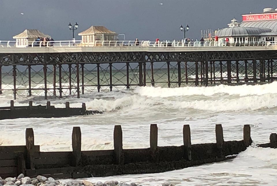
In this new series of blogs, the digital products team looks at the coastline of Great Britain, how it is changing and what important factors we should consider in terms of natural hazards, adaptation and resilience.
Coastal resilience is a key issue for our island nation, especially those who live and work around our coastline. The climate is changing, temperatures are increasing and sea-levels are set to rise. In recent years, we have witnessed numerous examples of coastal flooding, cliff falls and damage to infrastructure, businesses and homes during storms. But how much of an issue are these coastal vulnerabilities and what do we need to consider to increase our resilience to future events?
It is difficult to quantify the threat and potential economic impact of coastal erosion and flooding. The Climate Change Committee’s Adaptation Committee estimated in 2018 that, by the 2080s, over 100 000 properties may be in areas at risk from coastal erosion in England alone.
Various reports have been commissioned over recent years to assist in building a clearer picture of the situation and options to reduce this risk. The UK Government’s latest research on exploratory sea-level projections for the UK provides future projection ranges to the year 2300. Under all scenarios, sea level is expected to continue to rise. Estimates range across (approximately):
- 0.5 m to 2.2 m for low (RCP2.6) emissions
- 0.8 m to 2.6 m for medium-low (RCP4.5) emissions
- 1.4 m to 4.3 m for high (RCP8.5) emissions
To provide some context relating to the societal importance of our coastal regions, aside from their natural significance, we can consider some of the findings of a 2019 report by a Select Committee appointed through the House of Lords. This group and the subsequent report had been set up to focus on the regeneration of seaside towns and communities, which included a review of tourism and hospitality. Based on this report and the associated proceedings, the following numbers can be ascribed to our coastal regions:
- more than eight million people live on the coast, in coastal communities (Select Committee on Regenerating Seaside Towns and Communities (2018))
- according to UKHospitality, the sector employs 2.9 million people and generates £130 billion in economic activity
- VisitBritain stated that tourism was worth £127 billion to the British economy (Select Committee meeting).
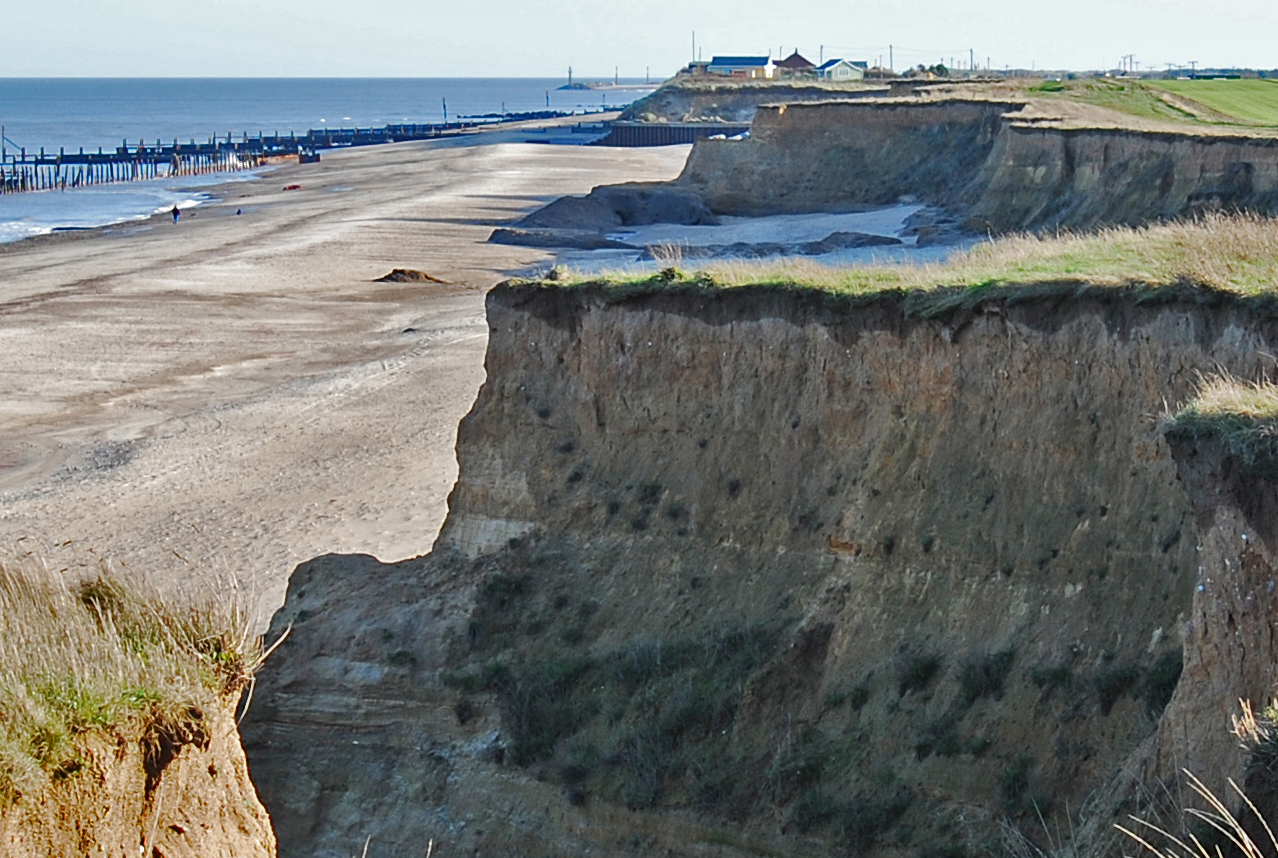
In the UK, current annual damages from coastal flooding are estimated at over £500 million per year (British Antarctic Survey) and costs are likely to increase under projections of future sea-level rise. Historic assets are also under threat: buried archaeology and historic structures, such as the Godwin Battery on Spurn Point, have already been lost to coastal erosion. The National Trust’s repair bill following the 2013/14 winter storms amounted to some £250 000, with other repairs costing many thousands of pounds.
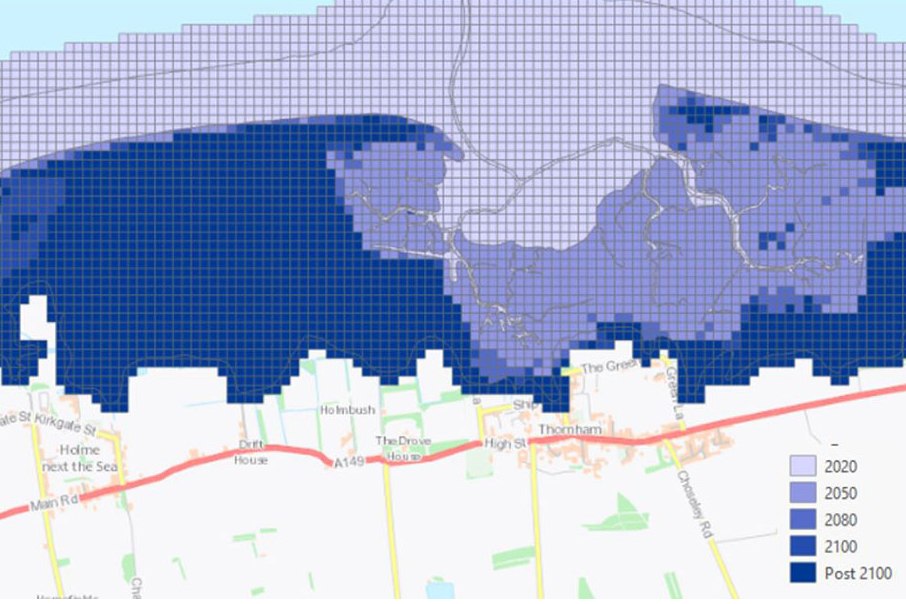
Our new GeoCoast data product can be used to inform and assist users when responding to coastal adaptation and resilience. GeoCoast is an integrated GIS package of datasets designed to inform and support coastal management and adaptation. It includes information about coastal erosion, sea-level rise and inundation, coastal subsidence and the properties of the geological deposits.
Our next post in this series will look at six areas of changing coastlines around Great Britain and how climate change could affect them.
Join us for our GeoCoast launch event
Join our data products team for a live webinar on the 28 April 2022, and discover more about our new data product to underpin coastal decision making, resilience and adaptation. > Register online
About the author

Kathryn Lee
Geologist and BGS Informatics product portfolio manager
Relative topics
You may also be interested in:
GeoCoast Premium
GeoCoast is an integrated GIS package of datasets designed to inform and support coastal management and adaptation.
Coasts and estuaries geohazards
Providing independent and expert geoscientific tools and advice to assess different adaptation options to coastal flooding and erosion.

New BGS datasets for coastal management, planning and adaptation in the face of climate change
BGS GeoCoast is a package of geospatial datasets designed to provide information on the geological conditions and constraints around the coastline of Britain.
Related news

Delving deep into mountains for future water security
16/07/2026
A BGS-led project is using new water-tracing investigation methods, geophysics and modelling to understand how water moves from mountains to the lowlands, helping to improve water security for billions of people.

Updated national 3D model will determine the depth to the solid bedrock beneath our feet
13/07/2026
The BGS Superficial Deposit Thickness Model now includes an elevation model of geological rockhead for the first time, providing important data for civil engineers, geoscientists and environmental scientists.

UK’s world-class research organisations launch new collective
10/07/2026
The launch of the National Research Organisations Group brings together more than 100 science leaders to provide an authorativive voice on science, research policy and long-term investment.

Cheshire Geoenergy Observatory releases key geological datasets for UK thermal energy storage scheme design
09/07/2026
A new report and data packs from BGS will provide a unique resource for scientists working on the geology and hydrogeology of the Sherwood Sandstone Formation, an important aquifer and reservoir rock.

New geological mapping underway to help manage flooding along the River Tweed
08/07/2026
Scientists are surveying the Tweed catchment for the first time in over 100 years to enhance understanding of localised groundwater and improve flood forecasting.

Geological research in North Sea helping to safeguard subsea cables
06/07/2026
Subsea power and telecommunications cables are critical to the UK’s energy infrastructure and global connectivity, yet they remain vulnerable to damage from ship anchors, fishing activity and natural hazards.

UK Critical Minerals Intelligence Centre makes recommendations for the next UK criticality assessment
01/07/2026
CMIC has outlined the enhancements made to the next assessment update to ensure it is better tailored to the structure of the UK economy.

From archive to discovery: historical mineral reports support gold exploration in Scotland
25/06/2026
Digitised geological records show potential to unlock untapped mineral resources in Ardlochan, Argyllshire.

UK and Philippines scientists investigate natural hydrogen generation processes at atomic scale
22/06/2026
BGS researchers were granted access to use the Diamond Light Source facility in order to study hydrogen in light brighter than the sun.

Shortage of end-of-life materials presents challenge to UK critical minerals security
17/06/2026
A new report by the UK Critical Minerals Intelligence Centre reveals insufficient end-of-life material stocks present a supply risk over the coming decade, but offer significant long-term potential to meet critical mineral demand through recycling.

UK geothermal catalogue receives update
16/06/2026
BGS releases the second digital version of the UK geothermal catalogue of subsurface temperature and rock thermal conductivity measurements and heat flow calculations.

Scientists make new discovery in the history of the Giant’s Causeway
15/06/2026
New research is changing our scientific understanding of the formation of one of the UK’s most iconic landmarks and has revealed that Northern Ireland’s volcanic past occurred over a much shorter period than previously thought.