The Kahraman Maraş earthquake sequence, Turkey/Syria, 2023
Two large earthquakes occurred within hours of each other on 6 February 2023.
14/02/2023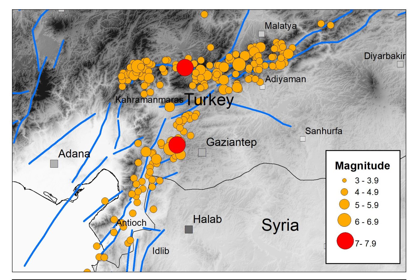

The devastating Kahraman Maraş earthquake sequence has caused widespread destruction and terrible loss of life across a large part of southern Turkey and northern Syria, with the collapse of thousands of buildings in populated areas throughout the region.
The earthquake sequence
The sequence started with a magnitude 7.8 earthquake at 01:17 UTC on 6 February 2023, rupturing a 200 km section of the north-east to south-west trending fault system that forms the boundary between the Anatolian and the Arabian tectonic plates. These plates are moving horizontally relative to each other at a speed of around 13 mm per year.
The earthquake took about 30 seconds to reach a maximum slip of around 3 m and resulted in intense shaking that lasted over a minute. Recorded ground accelerations at some sites close to the fault rupture exceeded 1.0 g. A few hours later, a magnitude 7.5 event occurred on a nearby branch of the fault system that trends east to west. This caused further strong ground shaking and destruction.
Previous seismicity in the area
The magnitude 7.8 earthquake was approximately 2.5 times bigger than the magnitude 7.4 Izmit earthquake in Turkey in 1999, which killed over 17 000 people, and was the same size as the magnitude 7.8 Erzincan earthquake in north-east Turkey in 1939, which killed over 32 000 people. The latter is considered the deadliest natural disaster in Turkey in the 20th century.
Although the earthquake risk in this part of southern Turkey was generally considered to be less than along the well-known Northern Anatolian Fault in northern Turkey, large and damaging earthquakes have struck here in the past. The city of Aleppo in northern Syria has been destroyed by several earthquakes in the last thousand years, including an earthquake in 1822 with over 20 000 fatalities.
The continuing hazard
Aftershocks are expected to cause moderate to severe ground shaking over a 300 to 500 km region for months to come. Some of these earthquakes may be several hundred kilometres away from other aftershocks and may be large enough to cause further damage, particularly to buildings that have already been weakened.
There have already been several aftershocks with a magnitude larger than 6.0. Our current understanding of the statistics of the aftershock process suggests that there may be several tens of earthquakes of this size or greater.
Over a period of months to years, the frequency of triggered seismicity (aftershocks) will reduce, with earthquake activity gradually returning to previous levels. Until then, earthquake hazard and risk in the region will remain heightened. This means that increased seismic hazard in the region where the two large earthquakes occurred is transient in nature, whilst longer seismic hazard estimates continue to be relevant.
Earthquake cascades
It is well established that large earthquakes can trigger seismicity on other nearby faults as the Earth’s Crust adjusts to the sudden change in stress. Both the permanent deformation caused by the initial earthquake and the passage of seismic waves through the Earth can trigger these subsequent earthquakes.
Other recent examples of this triggering process include the Kumamoto sequence on the island of Kyushu, Japan, in 2016, when a magnitude 6.5 earthquake was followed almost a day later by a magnitude 7.3 event. In Europe, the magnitude 6.0 Amatrice earthquake that occurred in Italy in 2016 was followed by the magnitude 6.5 Norcia earthquake two months later.
Although such cascading sequences of large-magnitude earthquake within short periods of time are relatively rare, investigation and analysis of these may promote a new understanding of the earthquake process.
Further information
About the authors

Dr Brian Baptie
Seismologist
Dr Margarita Segou
Earthquake seismologist
Relative topics
Related news

New NERC-funded project empowers young people to engage with environmental science
23/07/2026
BGS is part of a new, collaborative project, funded through NERC’s ‘Opening up the environment’ programme, helping the environmental research community become more accessible.

Delving deep into mountains for future water security
16/07/2026
A BGS-led project is using new water-tracing investigation methods, geophysics and modelling to understand how water moves from mountains to the lowlands, helping to improve water security for billions of people.

Updated national 3D model will determine the depth to the solid bedrock beneath our feet
13/07/2026
The BGS Superficial Deposit Thickness Model now includes an elevation model of geological rockhead for the first time, providing important data for civil engineers, geoscientists and environmental scientists.

UK’s world-class research organisations launch new collective
10/07/2026
The launch of the National Research Organisations Group brings together more than 100 science leaders to provide an authorativive voice on science, research policy and long-term investment.

Cheshire Geoenergy Observatory releases key geological datasets for UK thermal energy storage scheme design
09/07/2026
A new report and data packs from BGS will provide a unique resource for scientists working on the geology and hydrogeology of the Sherwood Sandstone Formation, an important aquifer and reservoir rock.

New geological mapping underway to help manage flooding along the River Tweed
08/07/2026
Scientists are surveying the Tweed catchment for the first time in over 100 years to enhance understanding of localised groundwater and improve flood forecasting.

Geological research in North Sea helping to safeguard subsea cables
06/07/2026
Subsea power and telecommunications cables are critical to the UK’s energy infrastructure and global connectivity, yet they remain vulnerable to damage from ship anchors, fishing activity and natural hazards.

UK Critical Minerals Intelligence Centre makes recommendations for the next UK criticality assessment
01/07/2026
CMIC has outlined the enhancements made to the next assessment update to ensure it is better tailored to the structure of the UK economy.

From archive to discovery: historical mineral reports support gold exploration in Scotland
25/06/2026
Digitised geological records show potential to unlock untapped mineral resources in Ardlochan, Argyllshire.

UK and Philippines scientists investigate natural hydrogen generation processes at atomic scale
22/06/2026
BGS researchers were granted access to use the Diamond Light Source facility in order to study hydrogen in light brighter than the sun.

Shortage of end-of-life materials presents challenge to UK critical minerals security
17/06/2026
A new report by the UK Critical Minerals Intelligence Centre reveals insufficient end-of-life material stocks present a supply risk over the coming decade, but offer significant long-term potential to meet critical mineral demand through recycling.

UK geothermal catalogue receives update
16/06/2026
BGS releases the second digital version of the UK geothermal catalogue of subsurface temperature and rock thermal conductivity measurements and heat flow calculations.