Six changing coastlines and how climate change could affect them
We explore how parts of the British coastline are changing and what important factors we should consider in terms of natural hazards, adaptation and resilience.
12/04/2022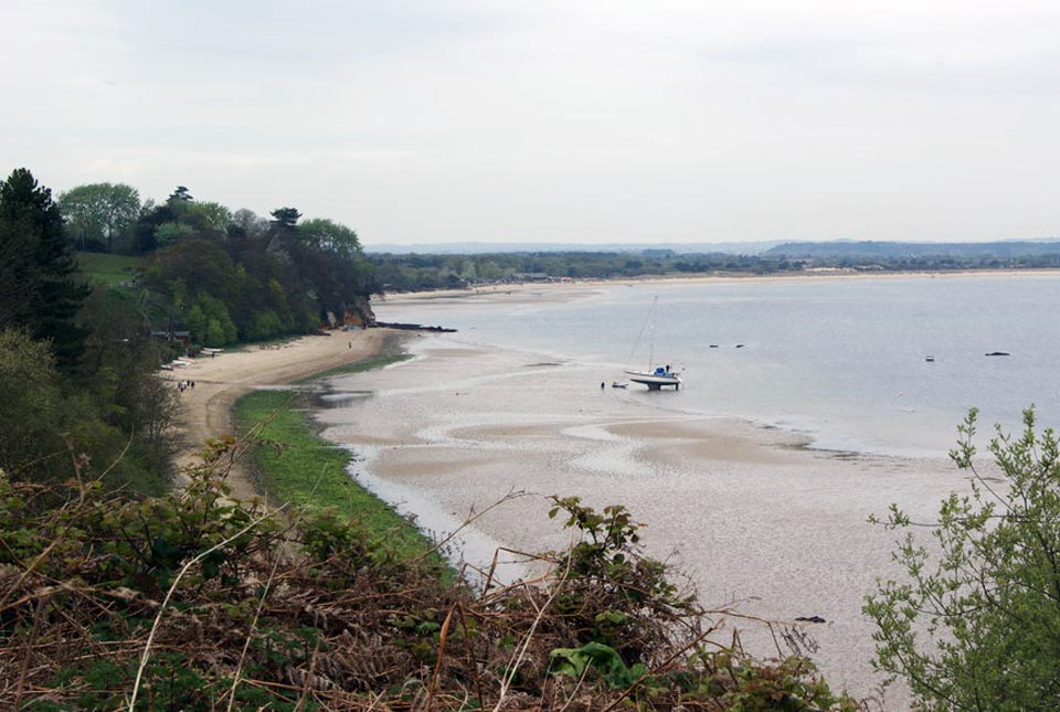

In our last post, we looked at the coastline of Great Britain, how it is changing and what important factors we should consider in terms of natural hazards, adaptation and resilience. In this article, we visit six key examples of natural environmental importance and explore their potential vulnerability to climate change.
The coastline of Great Britain, including its islands, is 31 368 km long, according to the Ordnance Survey (OS), with the mainland making up 17 819 km. Cornwall is the county with the longest coastline (1086 km) followed by Essex (905 km) and Devon (819 km). Our island nation experiences some of the largest tides in the world, with a range of up to 15 m, and a variety of geohazards and processes regularly have an impact on the changing coastline.
BGS has mapped the whole of the British coastline and now a new data product, GeoCoast, brings a whole range of data together into one package to help inform and interpret our coastal environment.
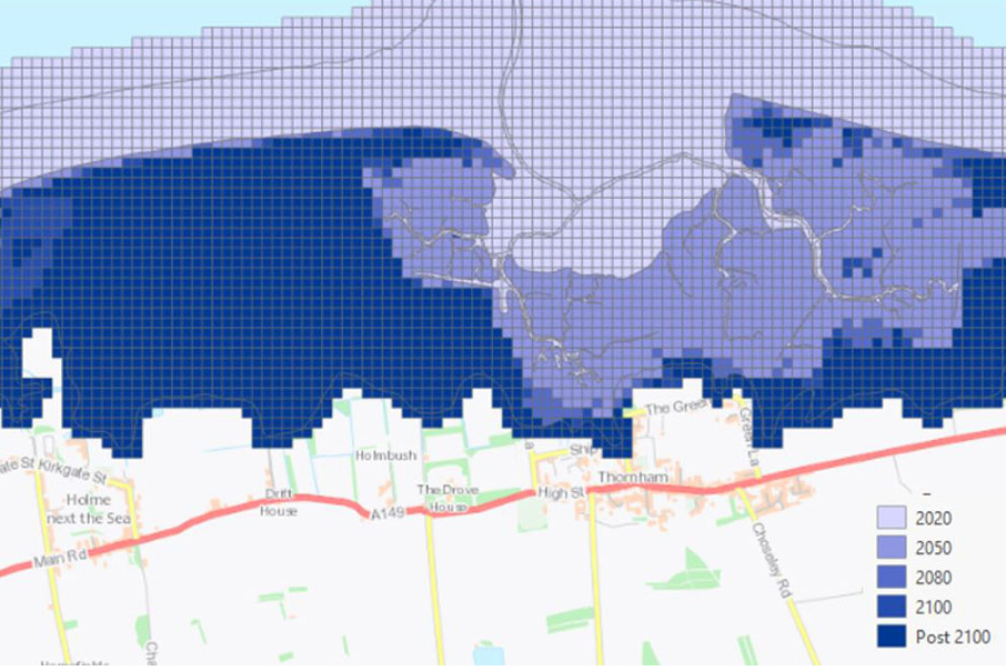
Spurn Point, East Yorkshire
View along the beach at Spurn Point. BGS © UKRI.
Overview
Spurn Point is three miles long, forming a natural protection for the Humber estuary and the port of Hull, as well as being an important site for migratory birds and other wildlife. It is an ever-changing environment composed of shingle beach and tidal flat deposits that is highly susceptible to coastal retreat. Formed as a long, narrow spit from deposits moving along the coast carried by currents, it has been breached by storms multiple times, notably in December 2013 by a huge tidal surge, bursting through the narrowest part of the spit and destroying the road.
A changing climate
Sea-level rise is predicted to completely cut off Spurn Head by 2050, according to modelled UKCP18 climate change scenarios.
More information
- Spurn National Nature Reserve
- Spurn Discovery Centre, Spurn Road, Kilnsea, Hull HU12 0UH
- Get there: take the A1033 from Hull
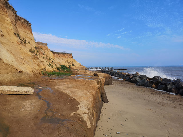
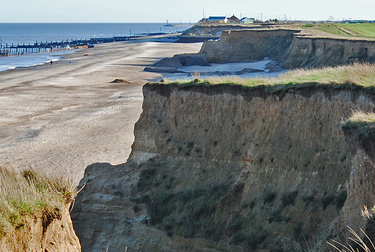
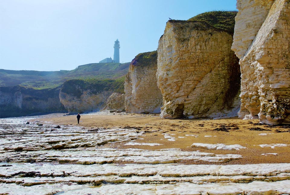
Flamborough Head, East Yorkshire
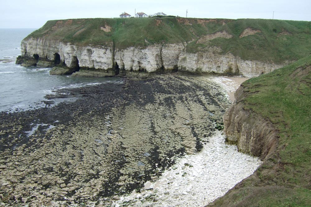
Landsliding in till at the top of the cliffs of Flamborough Head, North Yorkshire. BGS © UKRI.
Overview
Further north from Spurn Point, the geology at Flamborough Head comprises chalk cliffs capped by deposits of glacial till. Here, the chalk is more resistant to erosion than the overlying till, which is often unstable and can be susceptible to landslides.
A changing climate
Increased rainfall could increase the sensitivity of the till deposits to destabilisation. In addition, increased wave activity and storminess could impact the chalk at wave level, creating undercutting and cavities, which will eventually destabilise parts of the cliff.
More information
- Visit Danes Dyke nature reserve just a few miles from Flamborough Head. The nature reserve is characterised by its stunning array of wildlife, a flint boulder beach and chalk cliffs with fossils
- Flamborough Head car park, Flamborough, Bridlington YO15 1AR
- Get there: the nearest train station is Flamborough, or take the B1259
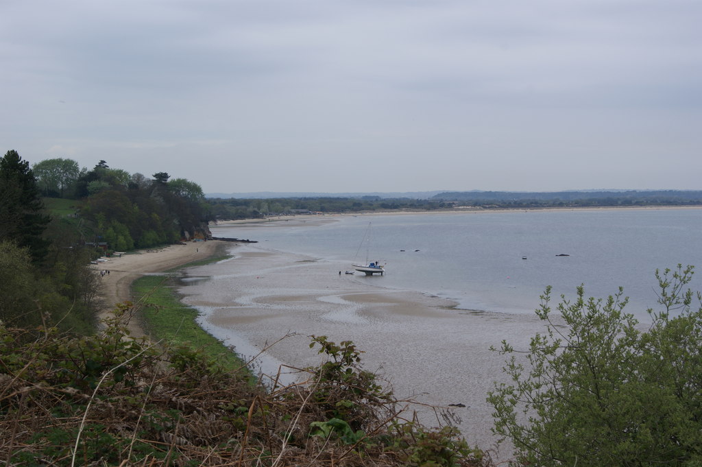
Holkham, Norfolk
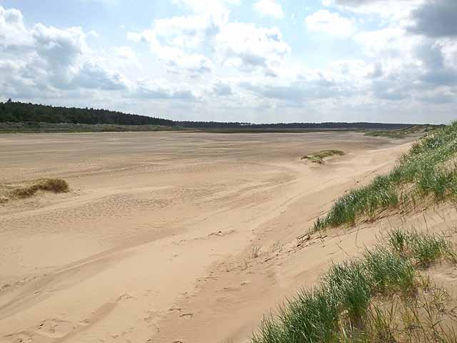
Slack behind Holkham beach. © Oliver Dixon.
Overview
Miles of empty dunes and sandy beaches at low tide, alongside estuaries, tidal creeks and salt marshes, Holkham is one of the most beautiful stretches of sand in England. This unique stretch of coastline attracts numerous nature lovers, walkers, horse riders and film makers. Some four miles long, the white sandy beach is backed by high dunes and pine woods, creating an important habitat, and is a designated Site of Special Scientific Interest (SSSI). The geology consists of tidal deposits, tidal flat and sand dunes, all with high susceptibility to coastal erosion and inundation.
The Holkham area suffered devastating consequences from floods in 1953 and 1978, then again on 5 December 2013 when a tidal surge flooded shops and homes in neighbouring Wells-next-the-Sea.
A changing climate
Continued effects of climate change are projected to see increased sea-level rises, resulting in a higher tidal reach into the tidal marshes and even higher storm surges, which could flood sensitive habitats, campsites and properties more frequently.
More information
- Holkham Nature Reserve
- Holkham beach
- Get there: the nearest train stations are Cromer (25 miles) and Sheringham (19 miles). Take thh B1105 from the south or the A149 from the east/west. Use NR23 1RH in your satnav for parking
Tillingham marshes, Essex
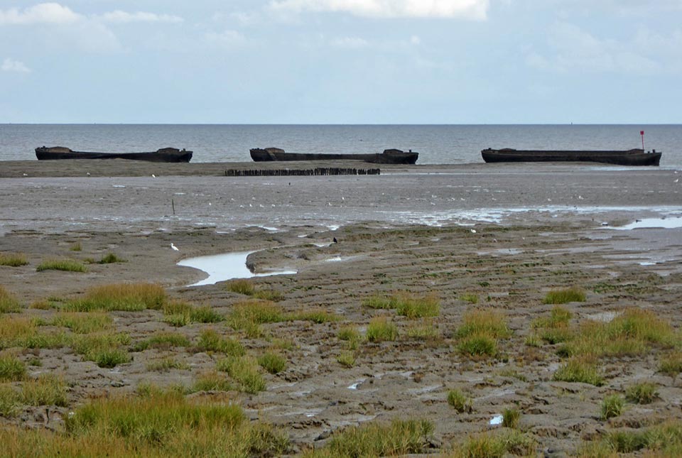
Sunken barges offshore at Tillingham. © Robin Webster.
Overview
The Dengie peninsula in Essex is a national nature reserve situated on low-lying land adjacent to the North Sea. There is evidence that the coastline was previously much further inland, as far as Tillingham village (which is 2 to 3 km from the coast). Earthen sea-wall embankments dating back to the Middle Ages have enabled the land to be reclaimed on the seaward side, forming an expansive area of saltmarsh, creeks and intertidal mudflats. This area is exposed to the waves and the saltmarsh landscape helps to attenuate the wave action, forming a natural defence against the sea.
The geology around this part of the coast is predominantly flat alluvial land, more gently undulating further inland with some steep slopes in the estuaries. The main superficial deposits are intertidal flats at the coast, fringed with saltmarsh with river terrace deposits and head landward, all underlain by the London Clay Formation.
A changing climate
Sea-level rises are accelerating erosion of the saltmarsh landward due to ‘coastal squeeze’ where the saltmarsh is eroded up against the seawall. The eroded sediment is then deposited on top of the existing saltmarsh and mudflats, building the height up on the seaward side so the marsh is higher than the land behind the seawall.
More information
- Get there: the nearest train station is Southminster, or take the B1021
Studland Bay, Dorset
Studland Bay. © Pam Goodey.
Overview
Frequent winter storms have meant loss of sand from Studland Bay over many years and, in 2014, one of the worst winter storm surges in 35 years resulted in a loss of up to 10 m of dunes in just one storm. The coastline is composed of sand dunes and beach deposits, underlain by the Broadstone Clay Member.
A changing climate
Projected increased sea-level rise and increased storminess will see the loss of these sand-rich deposits continue. The National Trust manages the coastline here and their focus is now on adaptation and the use of softer defences rather than the hard sea defences traditionally used.
More information
- Studland Bay National Trust
- Get there: you can reach Studland Bay on the B3351. Use BH19 3AH in your satnav for parking
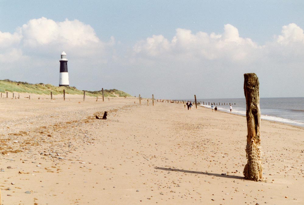
Dungeness, Kent
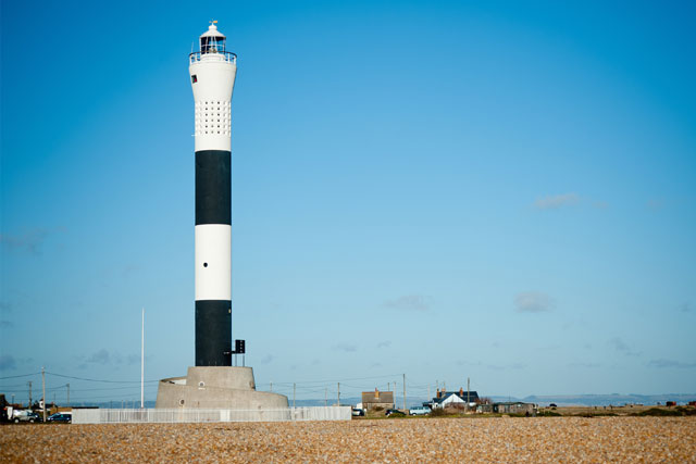
Lighthouse at Dungeness, Kent. BGS © UKRI.
Overview
Dungeness is situated at the southernmost point of Kent and is one of the most extensive examples of stable, vegetated shingle (gravel) in Europe, sheltering a large area of low-lying land.
Dungeness is almost entirely made up from flint shingle that has built up over the past six thousand years. The shingle has been redistributed over time forming a cuspate barrier, or ness, between its two shorelines. In addition to exposed shingle there are also buried shingle banks present. This barren landscape, with its landmark lighthouse, and also the site of a major nuclear power station, attracts around one million visitors annually.
The geology comprises predominantly storm beach and tidal flat deposits, alongside small amounts of blown sand and alluvium. These superficial deposits are underlain at depth by the Hasting Beds (sandstone, siltstone and mudstone).
A changing climate
Although some 30 per cent of the coastline is susceptible to erosion and 44 per cent (68km) could potentially be at risk of inundation by 2050, increasing slightly to 45 per cent (69km) by 2100, there is the requirement for continued sediment management to ensure the frontage at Dungeness nuclear power station is protected for the next 100 years..
More information
- RSPB Dungeness
- Get there: the nearest train station is Rye, one mile from Lydd on the Dungeness road. Use TN29 9PN in your satnav for parking
Further information
In our next post, we will discuss how our new GeoCoast data product can be used to inform and assist users when responding to coastal adaptation and resilience.
GeoCoast is an integrated GIS package of datasets designed to inform and support coastal management and adaptation. It includes information about coastal erosion, sea level rise and inundation, coastal subsidence and the properties of the geological deposits.
Join us for our GeoCoast launch event
Join our data products team for a live webinar on the 28 April 2022, and discover more about our new data product to underpin coastal decision making, resilience and adaptation. > Register online
About the author
Kathryn Lee
Geologist and BGS Informatics product portfolio manager
Relative topics
You may also be interested in
GeoCoast Premium
GeoCoast is an integrated GIS package of datasets designed to inform and support coastal management and adaptation.
GeoCoast Open
GeoCoast Open provides a range of historic images and diagrams extracted from our archives, memoirs and other publications, which can provide a reference for coastal change.
Coasts and estuaries geohazards
Providing independent and expert geoscientific tools and advice to assess different adaptation options to coastal flooding and erosion.
New BGS datasets for coastal management, planning and adaptation in the face of climate change
BGS GeoCoast is a package of geospatial datasets designed to provide information on the geological conditions and constraints around the coastline of Britain.
Related news

Updated geological assessment of the Southern North Sea set to underpin future offshore infrastructure development
25/03/2026
The first regional assessment for 30 years will support offshore marine and subsurface planning for the UK’s low-carbon energy infrastructure, including the 2030 target of 45 to 50 GW generated through offshore wind.

New research could help provide a more reliable water supply for millions in rural Africa
24/03/2026
A new BGS-led study has revealed crucial insights into the longstanding challenges affecting the reliability and performance of rural water supply infrastructure in sub-Saharan Africa.

Call for new members and Chair to join the NERC facilities steering committees
25/02/2026
New members are needed to join the committees over the next four years.

Your views wanted: developing a geothermal energy subsurface data portfolio
24/02/2026
BGS is aiming to support the growth of the sector by providing the best-available, location-specific geothermal and ground source heat information as an accessible product or service.

Map of BGS BritPits showing the distribution of worked mineral commodities across the country
18/02/2026
BGS’s data scientists have generated a summary map of the most commonly extracted mineral commodities by local authority area, demonstrating the diverse nature of British mineral resources.

Funding awarded to map the stocks and flows of technology metals in everyday electronic devices
12/02/2026
A new BGS project has been awarded Circular Electricals funding from Material Focus to investigate the use of technology metals in everyday electrical items.

New UK/Chile partnership prioritises sustainable practices around critical raw materials
09/02/2026
BGS and Chile’s Servicio Nacional de Geología y Minería have signed a bilateral scientific partnership to support research into critical raw materials and sustainable practices.

Extensive freshened water confirmed beneath the ocean floor off the coast of New England for the first time
09/02/2026
BGS is part of the international team that has discovered the first detailed evidence of long-suspected, hidden, freshwater aquifers.

Funding secured to help mitigate ground risk in UK construction sector
05/02/2026
The BGS Common Ground project has been awarded new funding to help unlock the value of ground investigation data.

Can sandstones under the North Sea unlock the UK’s carbon storage potential?
02/02/2026
For the UK to reach its ambitious target of storing 170 million tonnes of carbon dioxide per year by 2050, it will need to look beyond the current well-studied geographical areas.

Quaternary UK offshore data digitised for the first time
21/01/2026
The offshore wind industry will be boosted by the digitisation of a dataset showing the Quaternary geology at the seabed and the UK’s shallow subsurface.

Suite of ten new soil reference materials released
02/01/2026
BGS has a longstanding track record of producing high-quality reference materials and has released ten new soil reference materials.