New seabed geology maps for offshore Yorkshire
Offshore Yorkshire is the latest map to be released in BGS's series of fine-scale digital seabed maps.
14/03/2023 By BGS Press

BGS has initiated a new programme of mapping the seabed geology of the UK’s continental shelf, the first effort to consistently characterise the geology of the seabed in over 25 years.
The latest map offers new fine-scale digital maps featuring the seabed of offshore Yorkshire that contain combined bedrock, sediment, bedrock structure and geomorphology data. This is the third in a series of new, fine-scale maps to be released by BGS, with maps for offshore Anglesey and the Bristol Channel already available online.
The seabed geology maps are intended to support a diverse range of offshore activities and applications, including scientific research, offshore development, conservation efforts and marine management. It is part of a drive by BGS to develop new, fit-for-purpose geospatial products that, combined with the availability of new high-resolution data, can better meet current and future decarbonisation and marine science challenges. The maps are expected to be of interest to developers looking to deploy technology and infrastructure to create renewable energy.
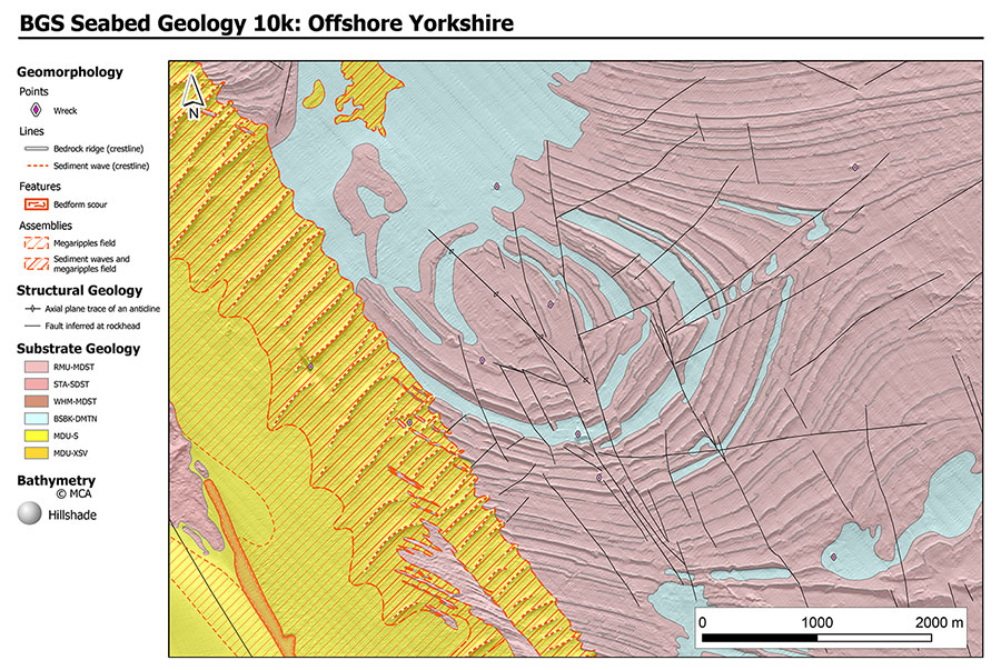
BGS Seabed Geology 10K: offshore Yorkshire. BGS © UKRI.
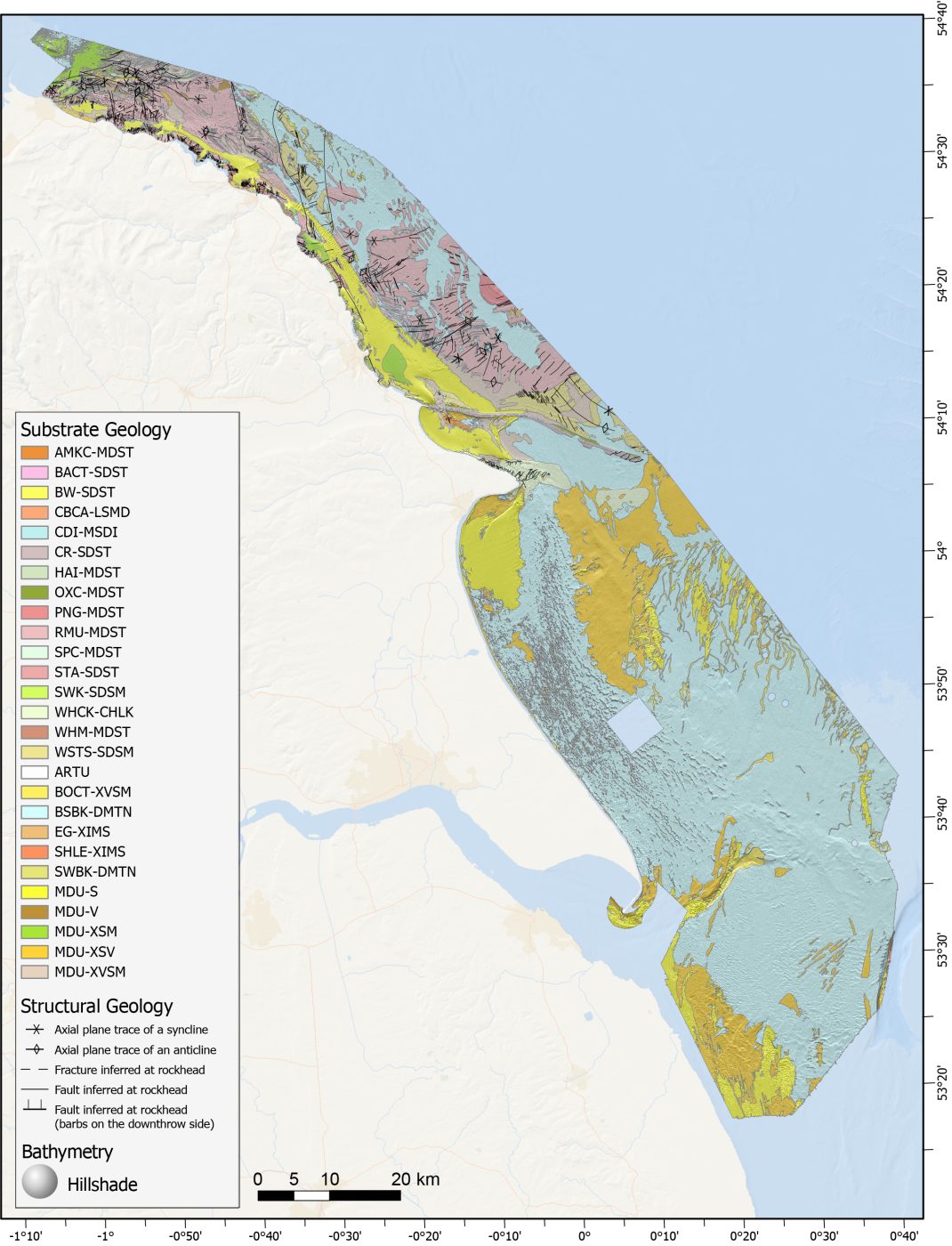
Substrate and structural geology from the full offshore Yorkshire map area. BGS © UKRI.
The maps are based primarily on high-resolution bathymetry data collected through the Maritime and Coastguard Agency’s UK Civil Hydrography Programme. They are further informed by acoustic backscatter data, sediment cores and grab samples, seismic data, and existing onshore and offshore map products (both BGS mapsand publicly available academic and industry products).

The geological character of the seabed and shallow subsurface is often complex, but is not well captured by currently available resources.
By applying a consistent approach nationally, incorporating both classical and innovative mapping approaches, these map products offer a unique resource, providing an excellent insight into complex geology, as well as active environmental processes.
Dayton Dove, BGS Marine Geoscientist.
BGS is among other public and government organisations to have joined the UK Centre for Seabed Mapping (UK CSM), helping to boost marine data and mapping standards. Improved geospatial resources will also provide important evidence for policy and decision makers, who need to consider the increasing demands placed on the marine environment from recreation, marine conservation and protection, resource development, and fisheries.
As well as providing important baseline datasets that can underpin efficiency in marine infrastructure projects, such as siting offshore renewables, the analysis and mapping process also leads to interesting new findings, providing the potential for genuine discovery.
Dayton Dove, BGS Marine Geoscientist.
The maps are available from BGS under the fine-scale maps section of the Offshore GeoIndex and are designed to be viewed at 1:10 000 scale, or offline as downloadable shapefiles.
Other areas to be added as the mapping programme progresses include offshore Orkney, East Anglia, and further areas of offshore Wales.
Other maps in this series:
Relative topics
Related news

Building Europe’s geological future
20/07/2026
BGS scientists are contributing to a continent-wide initiative that is strengthening collaboration across borders to tackle shared subsurface challenges and unlock new opportunities.

Delving deep into mountains for future water security
16/07/2026
A BGS-led project is using new water-tracing investigation methods, geophysics and modelling to understand how water moves from mountains to the lowlands, helping to improve water security for billions of people.

Collecting beach pebbles: fun hobby but is it legal?
14/07/2026
The UK coastline will be inundated with keen holidaymakers this summer, many of whom will take a memento of their trip home in the shape of a pebble or two — but is it legal?

Updated national 3D model will determine the depth to the solid bedrock beneath our feet
13/07/2026
The BGS Superficial Deposit Thickness Model now includes an elevation model of geological rockhead for the first time, providing important data for civil engineers, geoscientists and environmental scientists.

UK’s world-class research organisations launch new collective
10/07/2026
The launch of the National Research Organisations Group brings together more than 100 science leaders to provide an authorativive voice on science, research policy and long-term investment.

Cheshire Geoenergy Observatory releases key geological datasets for UK thermal energy storage scheme design
09/07/2026
A new report and data packs from BGS will provide a unique resource for scientists working on the geology and hydrogeology of the Sherwood Sandstone Formation, an important aquifer and reservoir rock.

New geological mapping underway to help manage flooding along the River Tweed
08/07/2026
Scientists are surveying the Tweed catchment for the first time in over 100 years to enhance understanding of localised groundwater and improve flood forecasting.

Geological research in North Sea helping to safeguard subsea cables
06/07/2026
Subsea power and telecommunications cables are critical to the UK’s energy infrastructure and global connectivity, yet they remain vulnerable to damage from ship anchors, fishing activity and natural hazards.

UK Critical Minerals Intelligence Centre makes recommendations for the next UK criticality assessment
01/07/2026
CMIC has outlined the enhancements made to the next assessment update to ensure it is better tailored to the structure of the UK economy.

From archive to discovery: historical mineral reports support gold exploration in Scotland
25/06/2026
Digitised geological records show potential to unlock untapped mineral resources in Ardlochan, Argyllshire.

UK and Philippines scientists investigate natural hydrogen generation processes at atomic scale
22/06/2026
BGS researchers were granted access to use the Diamond Light Source facility in order to study hydrogen in light brighter than the sun.

Shortage of end-of-life materials presents challenge to UK critical minerals security
17/06/2026
A new report by the UK Critical Minerals Intelligence Centre reveals insufficient end-of-life material stocks present a supply risk over the coming decade, but offer significant long-term potential to meet critical mineral demand through recycling.