Geology beneath the waves: developing maps and models of the sea floor
A special webinar focusing on our cutting-edge sea floor mapping research and an exciting new project exploring the deepest reaches of the world's oceans. A recording is now available.
Event on 23/11/2023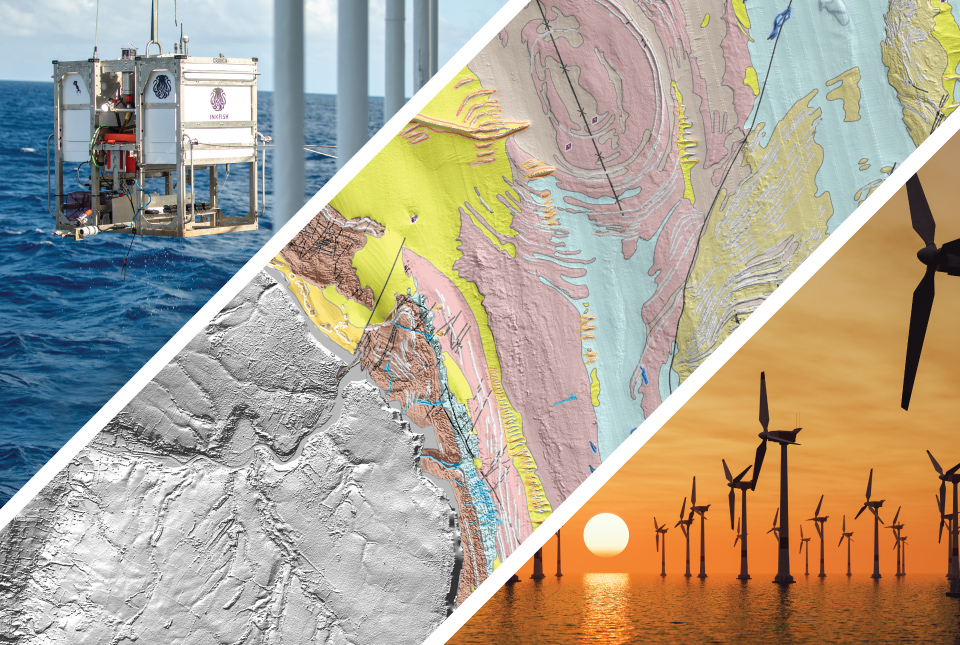
Over 70 per cent of the Earth’s surface lies beneath the waves of our seas and oceans. Most of this hidden world remains uncharted; however, scientific research, offshore development, conservation and marine management are all driving an increasing demand for offshore environmental data. This special webinar focuses on some of the cutting-edge geological sea floor mapping and modelling research that is currently being undertaken at BGS, which is both generating and using these state-of-the-art datasets.


The recording of the webinar is now available to watch online.
The webinar covers three areas of our current marine geoscience research:
- a new generation of geological mapping for the UK continental shelf and nearshore areas, highlighting key drivers for the mapping and the science that underpins it
- enhancing our understanding of sea-floor geology and developing ‘ground models’ of the shallow subsurface, providing vital support to the rapidly growing offshore renewable industry
- working with global partners on an exciting new research programme, exploring seascapes in the deepest reaches of the world’s oceans
The webinar concludes with a Q&A session, with BGS geoscientists answering questions from attendees
BGS Strategy 2023 to 2028: Understanding our Earth
Humanity faces major global challenges that require recurrent and serious consideration by decision makers. BGS have developed a programme of science to meet societal needs, with a focus on four strategic priorities:
- producing maps and models for the 21st century
- supporting a more secure energy transition
- improving water security
- living with geological hazards
Through public engagement, we aim to inspire the wider community and inform societal debate and decisions on geological solutions to global challenges.
For more information please read our full strategy.
Related news

Geological research in North Sea helping to safeguard subsea cables
06/07/2026
Subsea power and telecommunications cables are critical to the UK’s energy infrastructure and global connectivity, yet they remain vulnerable to damage from ship anchors, fishing activity and natural hazards.

UK scientists unite for seabed mapping survey of the UK’s south-west coastline
15/04/2026
BGS geologists join research voyage, gathering crucial geological data to support offshore energy and infrastructure projects.

Updated geological assessment of the Southern North Sea set to underpin future offshore infrastructure development
25/03/2026
The first regional assessment for 30 years will support offshore marine and subsurface planning for the UK’s low-carbon energy infrastructure, including the 2030 target of 45 to 50 GW generated through offshore wind.

Extensive freshened water confirmed beneath the ocean floor off the coast of New England for the first time
09/02/2026
BGS is part of the international team that has discovered the first detailed evidence of long-suspected, hidden, freshwater aquifers.

Quaternary UK offshore data digitised for the first time
21/01/2026
The offshore wind industry will be boosted by the digitisation of a dataset showing the Quaternary geology at the seabed and the UK’s shallow subsurface.

Offshore Quaternary 250K
The 1:250 000-scale offshore geological map for quaternary geology (BGS Geology: marine quaternary 250k) is available digitally.

How the geology on our doorstep can help inform offshore infrastructure design
19/11/2025
BGS is part of a new collaboration using onshore field work to contextualise offshore data and update baseline geological models which can inform the sustainable use of marine resources.

Extended seabed geology map of the Bristol Channel published
07/10/2025
BGS has released significantly extended high-resolution maps that will support offshore green-energy initiatives in the area.

New seabed sediment maps reveal what lies beneath the waves
03/09/2025
Marine ecosystem science and offshore infrastructure will be boosted by a new dataset showing sediment composition across the UK continental shelf.

Seabed sediments 250K
This offshore Quaternary geology dataset shows the distribution of interpreted lithostratigraphical units within the shallow subsurface. The dataset represents the Quaternary geology immediately beneath the active seabed sediment layer.

Offshore bedrock 250K
The BGS Offshore Bedrock 250k dataset depicts the distribution of the different types of bedrock on the UK Continental Shelf.

IODP³-NSF Expedition 501: successful offshore operations launches onshore phase
06/08/2025
Scientists have managed to take water and sediment samples from beneath the ocean on the New England Shelf for the first time, with the intention of understanding this offshore aquifer system.