Extended seabed geology map of the Bristol Channel published
BGS has released significantly extended high-resolution maps that will support offshore green-energy initiatives in the area.
07/10/2025 By BGS Press

Renewable energy infrastructure, whether on- or offshore, requires in-depth understanding and accurate characterisation of the underlying geology. Developers increasingly need detailed geospatial observations of the seabed and shallow subsurface, which are critical to the siting and design of offshore infrastructure such as submarine cables and offshore wind turbines. This is certainly true in the Bristol Channel, which is home to the second largest tidal range in the world. This high-energy environment has attracted much interest around the use of the seabed for tidal power and the potential to produce electricity from wave energy.
To support policy- and decision makers in this region, BGS has released an enhanced seabed geology map of the Bristol Channel, almost four times the size of the original, which extends from Carmarthen Bay to Newport and further south to the coast of Somerset.
Beyond offshore infrastructure, these maps also directly contribute to understanding of marine ecosystems, coastal management and defence activities. The data provides crucial information to those ensuring the port facilities along this coastline meet the requirements for these development opportunities.
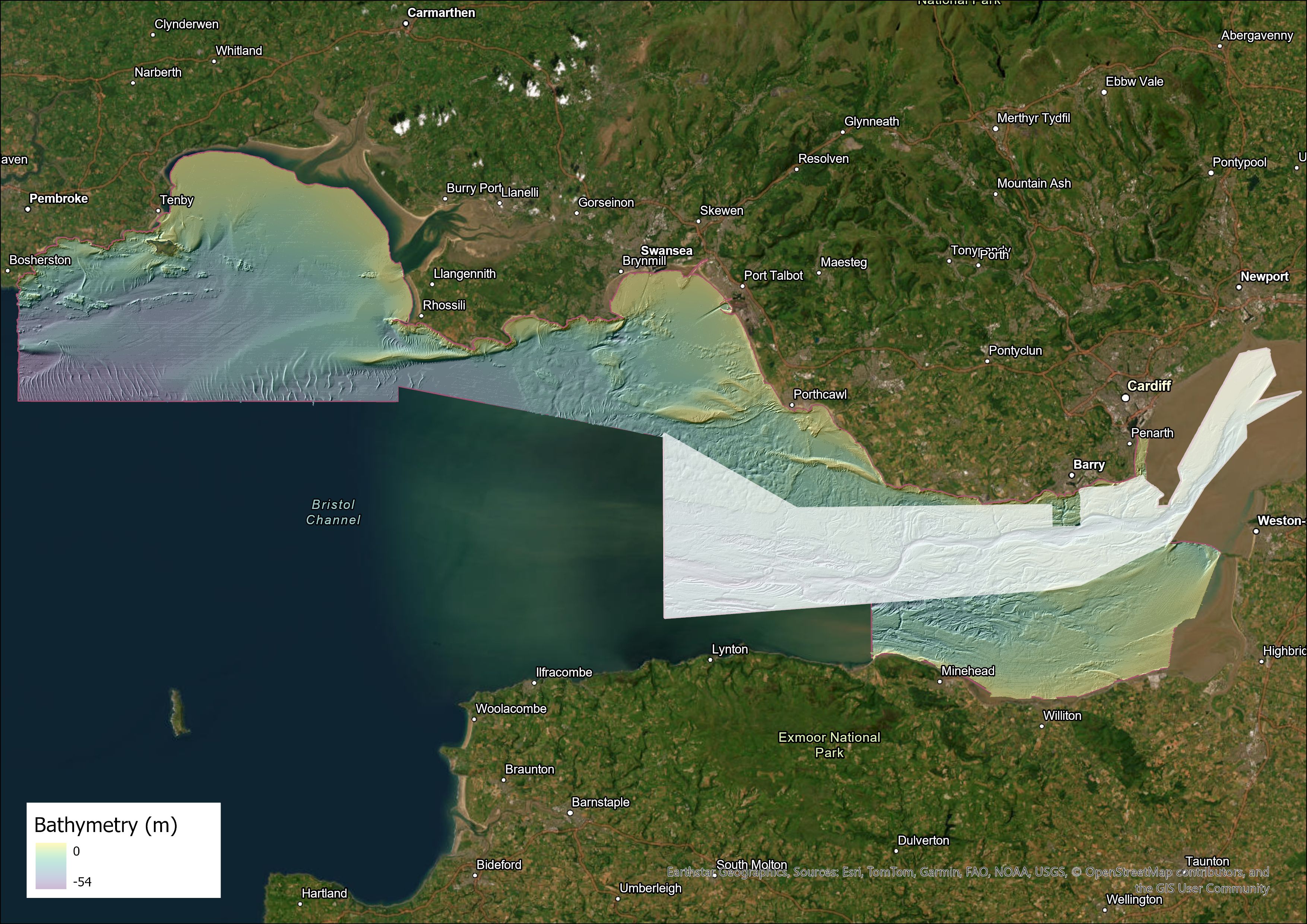
Extent of the extended Bristol Channel map, with the original shown in white. Contains OS data © Crown Copyright and database right 2020. The derived bathymetric layer was produced from Maritime and Coastguard Agency (MCA) data © Crown copyright. Not to be used for navigational purposes. BGS © UKRI.
As the UK’s transition to renewable energy gathers pace, these maps will become increasingly valuable to industry and stakeholders with an interest in developing clean energy, from offshore wind to tidal streaming, and in carbon capture and storage.

The successful implementation of offshore renewable energy projects and technologies and the development of ports in South Wales require a detailed understanding of the seabed. This new, expanded, fine-scale seabed map of the Bristol Channel will be an invaluable resource for developers, providing access to high-quality, detailed observations of the seabed geology that is vital to these kinds of developments.
Beyond its critical role in supporting the renewables sector, the map will also be useful to other data users, such as those involved with supporting marine ecosystems, coastal management and defence activities. It will also provide evidence for policy- and decision makers in the region.
Rhian Kendall, BGS Chief Geologist for Wales.
The map, featuring combined bedrock, sediment, bedrock structure and seabed geomorphology data, is available from BGS under the fine-scale maps section of the Offshore GeoIndex and is designed to be viewed at 1:10 000 scale, or online as downloadable shapefiles. For information on licensing the downloadable GIS data (ESRI format), please contact digitaldata@bgs.ac.uk.
Relative topics
Related news

New NERC-funded project empowers young people to engage with environmental science
23/07/2026
BGS is part of a new, collaborative project, funded through NERC’s ‘Opening up the environment’ programme, helping the environmental research community become more accessible.

Delving deep into mountains for future water security
16/07/2026
A BGS-led project is using new water-tracing investigation methods, geophysics and modelling to understand how water moves from mountains to the lowlands, helping to improve water security for billions of people.

Updated national 3D model will determine the depth to the solid bedrock beneath our feet
13/07/2026
The BGS Superficial Deposit Thickness Model now includes an elevation model of geological rockhead for the first time, providing important data for civil engineers, geoscientists and environmental scientists.

UK’s world-class research organisations launch new collective
10/07/2026
The launch of the National Research Organisations Group brings together more than 100 science leaders to provide an authorativive voice on science, research policy and long-term investment.

Cheshire Geoenergy Observatory releases key geological datasets for UK thermal energy storage scheme design
09/07/2026
A new report and data packs from BGS will provide a unique resource for scientists working on the geology and hydrogeology of the Sherwood Sandstone Formation, an important aquifer and reservoir rock.

New geological mapping underway to help manage flooding along the River Tweed
08/07/2026
Scientists are surveying the Tweed catchment for the first time in over 100 years to enhance understanding of localised groundwater and improve flood forecasting.

Geological research in North Sea helping to safeguard subsea cables
06/07/2026
Subsea power and telecommunications cables are critical to the UK’s energy infrastructure and global connectivity, yet they remain vulnerable to damage from ship anchors, fishing activity and natural hazards.

UK Critical Minerals Intelligence Centre makes recommendations for the next UK criticality assessment
01/07/2026
CMIC has outlined the enhancements made to the next assessment update to ensure it is better tailored to the structure of the UK economy.

From archive to discovery: historical mineral reports support gold exploration in Scotland
25/06/2026
Digitised geological records show potential to unlock untapped mineral resources in Ardlochan, Argyllshire.

UK and Philippines scientists investigate natural hydrogen generation processes at atomic scale
22/06/2026
BGS researchers were granted access to use the Diamond Light Source facility in order to study hydrogen in light brighter than the sun.

Shortage of end-of-life materials presents challenge to UK critical minerals security
17/06/2026
A new report by the UK Critical Minerals Intelligence Centre reveals insufficient end-of-life material stocks present a supply risk over the coming decade, but offer significant long-term potential to meet critical mineral demand through recycling.

UK geothermal catalogue receives update
16/06/2026
BGS releases the second digital version of the UK geothermal catalogue of subsurface temperature and rock thermal conductivity measurements and heat flow calculations.