Seabed geology data: results from stakeholder consultation
BGS collected valuable stakeholder feedback as part of a new Crown Estate-led initiative to improve understanding of national-scale seabed geology requirements.
31/01/2025 By BGS Press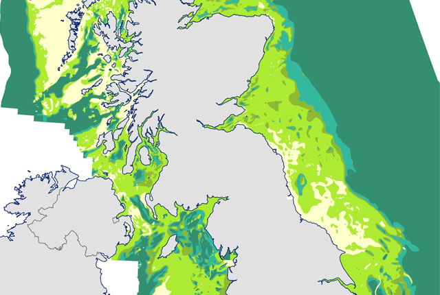

The Crown Estate uses cutting-edge data to create safe, sustainable and cost-effective new opportunities for future developments, in line with commitments to net zero and nature recovery. BGS was approached by The Crown Estate to undertake a project aimed at better understanding the current and future requirements for national-scale seabed geology and shallow subsurface information across multiple marine sectors, focusing on offshore renewables, linear assets and nature.
The project built on previous collaboration between BGS and The Crown Estate in 2014, which developed a series of geological factor maps relevant to offshore seabed activities. The availability of new data and techniques provides a timely opportunity to review evolving needs.
Part of the project involved an online survey, which included more than 80 participants from at least 60 different organisations. Participants provided feedback about access and use, seabed geology information, thematic data needs, and where improvements to existing datasets or addition of new datasets could be made. Alongside the survey, we undertook a review of existing seabed geology datasets and used it in conjunction with the survey results to inform recommendations for a potential new data compilation.
We would like to thank all participants for their input to the survey. If you have any questions, please contact the BGS Offshore Data Team (offshoredata@bgs.ac.uk).
Relative topics
Related news

UK scientists unite for seabed mapping survey of the UK’s south-west coastline
15/04/2026
BGS geologists join research voyage, gathering crucial geological data to support offshore energy and infrastructure projects.

Updated geological assessment of the Southern North Sea set to underpin future offshore infrastructure development
25/03/2026
The first regional assessment for 30 years will support offshore marine and subsurface planning for the UK’s low-carbon energy infrastructure, including the 2030 target of 45 to 50 GW generated through offshore wind.

Extensive freshened water confirmed beneath the ocean floor off the coast of New England for the first time
09/02/2026
BGS is part of the international team that has discovered the first detailed evidence of long-suspected, hidden, freshwater aquifers.

Quaternary UK offshore data digitised for the first time
21/01/2026
The offshore wind industry will be boosted by the digitisation of a dataset showing the Quaternary geology at the seabed and the UK’s shallow subsurface.

Offshore Quaternary 250K
The 1:250 000-scale offshore geological map for quaternary geology (BGS Geology: marine quaternary 250k) is available digitally.

How the geology on our doorstep can help inform offshore infrastructure design
19/11/2025
BGS is part of a new collaboration using onshore field work to contextualise offshore data and update baseline geological models which can inform the sustainable use of marine resources.

Extended seabed geology map of the Bristol Channel published
07/10/2025
BGS has released significantly extended high-resolution maps that will support offshore green-energy initiatives in the area.

New seabed sediment maps reveal what lies beneath the waves
03/09/2025
Marine ecosystem science and offshore infrastructure will be boosted by a new dataset showing sediment composition across the UK continental shelf.

Seabed sediments 250K
This offshore Quaternary geology dataset shows the distribution of interpreted lithostratigraphical units within the shallow subsurface. The dataset represents the Quaternary geology immediately beneath the active seabed sediment layer.

Offshore bedrock 250K
The BGS Offshore Bedrock 250k dataset depicts the distribution of the different types of bedrock on the UK Continental Shelf.

IODP³-NSF Expedition 501: successful offshore operations launches onshore phase
06/08/2025
Scientists have managed to take water and sediment samples from beneath the ocean on the New England Shelf for the first time, with the intention of understanding this offshore aquifer system.
BGS scientists join international expedition off the coast of New England
20/05/2025
Latest IODP research project investigates freshened water under the ocean floor.