Moving stones: faults, slopes and sediments
Fractured rock along faults affects sediment movement on slopes with implications for the design of infrastructure.
12/01/2024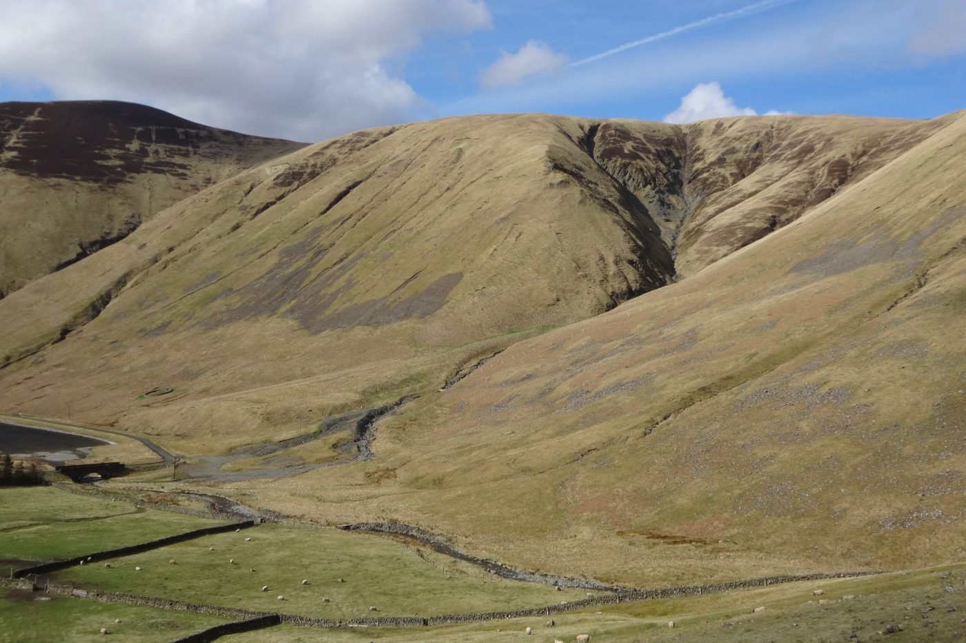

Deposits on upland hillslopes are formed by a range of processes like debris flows, rock falls, slope wash and soil creep. The movement of sediment by these processes occurs over days, years or decades and can have far-reaching implications. Over geological timescales it can influence the relief of mountain ranges, but on human timescales it is also a potential geohazard affecting roads, bridges, and reservoirs, and a key factor in managing river habitats and water quality.
Faults are important geological features, even when they are no longer active tectonic structures. They are often associated with highly fractured ‘damage zones’ that are relatively weak, providing abundant source material for slope processes and acting as conduits for groundwater flow. We investigated how faults control the types of deposits that are produced on upland slopes by weathering and erosion, and how the direction of a fault’s intersection with a hillside influences the way sediment is mobilised and transported to rivers and reservoirs.
Study area: Tweedsmuir Hills, Scotland
In the Tweedsmuir Hills, in Scotland’s Southern Uplands, the rolling upland landscape is bisected by a series of brittle faults comprising highly fractured damage zones in the otherwise hard, metasedimentary rocks. The study area, at the head of the Talla Reservoir, provides a prime opportunity to compare the geomorphological imprint of slope-oblique faults that traverse across a slope at a low angle (roughly perpendicular to the slope direction) with that of slope-parallel faults (roughly parallel to the slope direction).
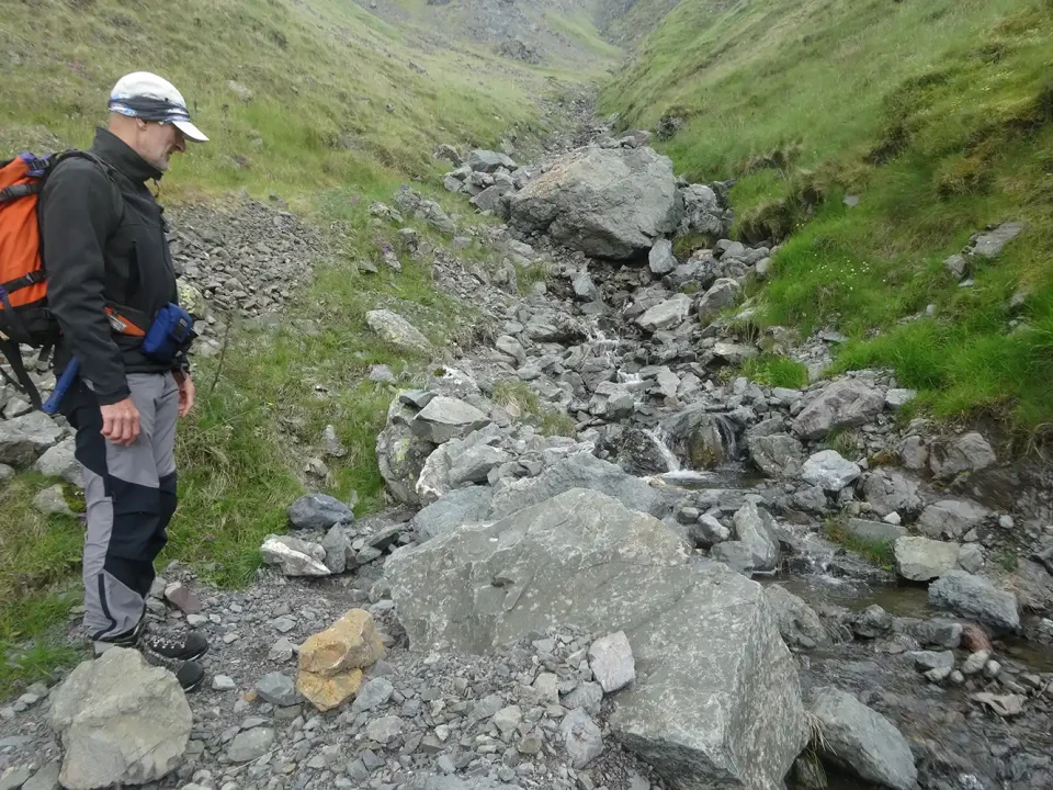
Examining debris flow deposits in the Codleteth Burn, Talla, Southern Uplands. BGS © UKRI.
Faults that traverse slopes at low angles are associated with enhanced regolith (weathered bedrock) production, which forms a more-or less continuous spread of colluvial deposits (loose sediments that move downslope under gravity) across the slope. Sediment transfer to the valley floor is limited because topographical breaks associated with the slope-crossing structures disrupt gully systems and inhibit sediment ‘flow’ downslope.
By contrast, slope-parallel faults are associated with more focused erosion along fault zones, giving rise to a deep and well-connected gully system. The alignment of slope and fault directions creates positive feedback, which enhances downslope erosion and transport to the valley floor. This feedback has resulted in approximately 20 times more rock being eroded per metre of fault length than in the slope-oblique fault system.
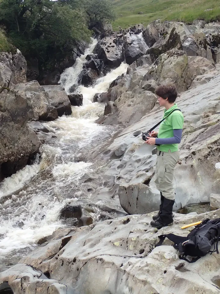
Observing the sparsely fractured (unfaulted) wacke sandstone in the bed of the Gameshope Burn. BGS © UKRI.
Influence on infrastructure design
The movement of sediment is associated with geohazards such as debris flows and rock falls as well as slope instability that can damage upland transport, energy and water infrastructure. However, sediment movement on slopes is a natural part of how our landscape behaves and interrupting or altering the flow of sediment from hillslopes into streams can affect river environments and habitats, and influence water quality in reservoirs.
Understanding the mechanisms of active slope processes and their distributions within the landscape is necessary to ensure we can design effective approaches for managing both the impact of moving sediment on our built infrastructure, and the effect this infrastructure has on our rivers and reservoirs.
Another way of looking at it is that every slope has its own story. Our work in Talla demonstrates how geomorphological mapping and quantitative field analysis can be used to help understand the dynamics of slope systems, adding to our knowledge of the ‘language’ of slopes. By understanding how their past geological history influences their present processes, we can learn to better ‘read’ slopes and ensure we develop more positive relationships with them.
About the authors

Dr Katie Whitbread
Survey geologist
Relative topics
Reference
Whitbread, K, Thomas, C, and Finlayson, A. 2023. The influence of bedrock faulting and fracturing on sediment availability and Quaternary slope systems, Talla, Southern Uplands, Scotland, UK. Proceedings of Geologists’ Association, in press. DOI: https://doi.org/10.1016/j.pgeola.2023.11.003
Latest news

Delving deep into mountains for future water security
16/07/2026
A BGS-led project is using new water-tracing investigation methods, geophysics and modelling to understand how water moves from mountains to the lowlands, helping to improve water security for billions of people.

Updated national 3D model will determine the depth to the solid bedrock beneath our feet
13/07/2026
The BGS Superficial Deposit Thickness Model now includes an elevation model of geological rockhead for the first time, providing important data for civil engineers, geoscientists and environmental scientists.

UK’s world-class research organisations launch new collective
10/07/2026
The launch of the National Research Organisations Group brings together more than 100 science leaders to provide an authorativive voice on science, research policy and long-term investment.

Cheshire Geoenergy Observatory releases key geological datasets for UK thermal energy storage scheme design
09/07/2026
A new report and data packs from BGS will provide a unique resource for scientists working on the geology and hydrogeology of the Sherwood Sandstone Formation, an important aquifer and reservoir rock.

New geological mapping underway to help manage flooding along the River Tweed
08/07/2026
Scientists are surveying the Tweed catchment for the first time in over 100 years to enhance understanding of localised groundwater and improve flood forecasting.

Geological research in North Sea helping to safeguard subsea cables
06/07/2026
Subsea power and telecommunications cables are critical to the UK’s energy infrastructure and global connectivity, yet they remain vulnerable to damage from ship anchors, fishing activity and natural hazards.

UK Critical Minerals Intelligence Centre makes recommendations for the next UK criticality assessment
01/07/2026
CMIC has outlined the enhancements made to the next assessment update to ensure it is better tailored to the structure of the UK economy.

From archive to discovery: historical mineral reports support gold exploration in Scotland
25/06/2026
Digitised geological records show potential to unlock untapped mineral resources in Ardlochan, Argyllshire.

UK and Philippines scientists investigate natural hydrogen generation processes at atomic scale
22/06/2026
BGS researchers were granted access to use the Diamond Light Source facility in order to study hydrogen in light brighter than the sun.

Shortage of end-of-life materials presents challenge to UK critical minerals security
17/06/2026
A new report by the UK Critical Minerals Intelligence Centre reveals insufficient end-of-life material stocks present a supply risk over the coming decade, but offer significant long-term potential to meet critical mineral demand through recycling.

UK geothermal catalogue receives update
16/06/2026
BGS releases the second digital version of the UK geothermal catalogue of subsurface temperature and rock thermal conductivity measurements and heat flow calculations.

Scientists make new discovery in the history of the Giant’s Causeway
15/06/2026
New research is changing our scientific understanding of the formation of one of the UK’s most iconic landmarks and has revealed that Northern Ireland’s volcanic past occurred over a much shorter period than previously thought.