Introducing the BGS Debris Flow Susceptibility Model for Great Britain
Debris flows are a landslide hazard of particular concern to transport infrastructure managers and local authorities.
21/11/2022 By BGS Press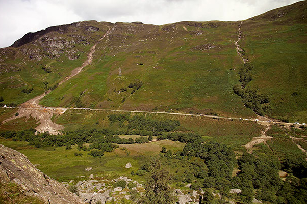
Debris flows are landslide hazard that are of particular concern to transport infrastructure managers and local authorities. They occur when poorly sorted debris mixed with water rapidly flow downslope and are potentially very destructive. Debris flows can cause considerable disruption and financial loss, particularly for owners or managers of infrastructure assets (for example road or rail), utilities or property. With increases in rainfall combined with dry weather anticipated, the UK climate change risk assessment (2021) specifically highlights future risks to transport networks from slope and embankment failure, particularly on routes in more rural areas of the UK that follow natural features such as steep-sided valleys.
In response to increasing demand for knowledge about where debris flows may potentially occur in Great Britain, BGS developed a debris flow susceptibility model for Great Britain (BGS DFSM-GB), which has been updated recently. This dataset is designed for those interested specifically in debris flow susceptibility at a regional or national planning scale, such as those involved in construction or maintenance of infrastructure networks (road, rail or utilities), other asset managers, loss adjusters, surveyors or local government.
Armed with knowledge about potential debris flows, preventative steps can be put in place to alleviate the impact of the hazard to people and assets.
About debris flow hazards
Debris flows are a widespread phenomenon in mountainous terrain. They are distinct from other types of landslides as they can occur periodically on established paths, usually gullies or existing drainage channels. Periods of prolonged and intense rainfall are a common trigger for this type of hazard and, with changes in seasonal UK precipitation patterns generally accepted as a likely consequence of ongoing climate change, the magnitude and frequency of debris flows are likely to change.
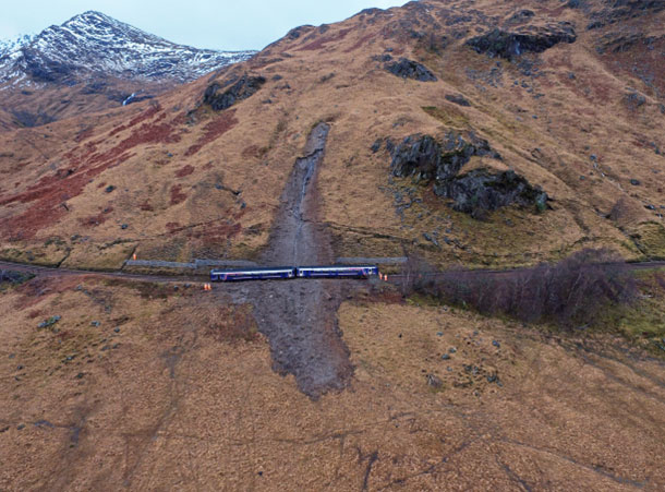
In Great Britain, most disruptive debris flow events are recorded on the Scottish road and rail network. For example, the A83 ‘Rest and Be Thankful’ Pass suffers regular blockages and closures and, although event magnitudes are usually relatively small, the disruption caused can have significant economic effects. The pass is a strategic link road to the Kintyre peninsula and other remote regions of western Scotland, and regular closures force a 55-mile diversion. A study, ‘Extending natural hazard impacts: an assessment of landslide disruptions on a national road transportation network’, suggests that the direct and indirect economic effects of a single event there in 2007 were estimated at £1.2 million over a 15-day closure.
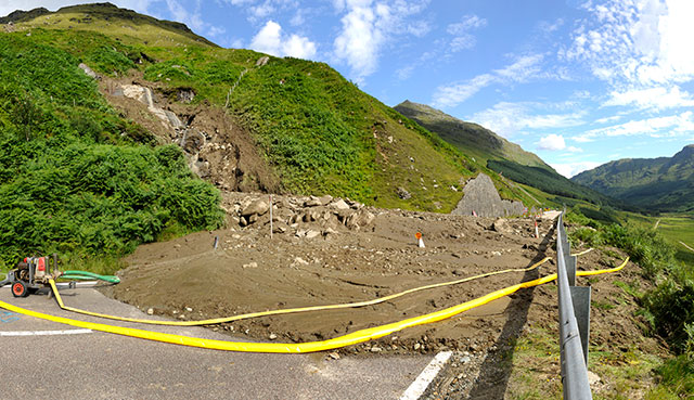

A83 road up to the ‘Rest and Be Thankful’ pass, Scotland, blocked by a debris flow in August 2012. BGS © UKRI.
Real-life incidents
As well as issues such as economic costs and inconvenience caused by disruption to travel networks, debris flows pose a threat to public safety. Near-miss examples highlight the dangers this landslide hazard poses. In August 2004, two debris flows blocked the A85 in Glen Ogle, stranding 57 people between them, some of whom required rescue via airlift. In June 2012, a debris flow blocked a railway near Loch Trieg; it was struck by a freight engine resulting in derailment of the engine and injury to the driver.A similar incident occurred in January 2018, when an occupied passenger train was derailed near Loch Eilt after hitting a debris flow deposit.
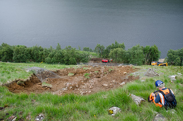
Stob Coire Sgrodain debris flow near Loch Trieg, Scotland. The debris flow covered railway tracks and caused a freight engine derailment on the Fort William to Crianlarich railway line, June 2012. BGS © UKRI.
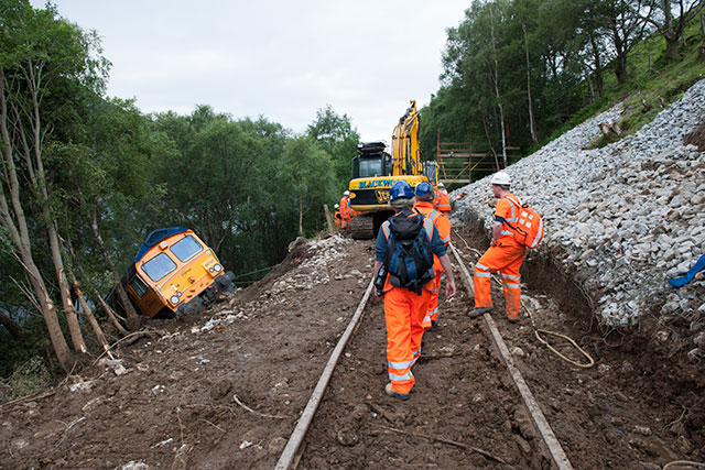
Stob Coire Sgrodain debris flow near Loch Trieg, Scotland. Repairs underway to the Fort William to Crianlarich railway line after a debris flow, June 2012. BGS © UKRI.
This debris flow covered railway tracks and caused the derailment of a passenger train on the West Highland line between Glasgow and Mallaig in the Scottish Highlands, near Loch Eilt. Image source: Rail Accident Investigation Branch report 10/2018: Landslip and derailment at Loch Eilt. © Crown copyright 2022.
About the dataset
Despite debris flows being relatively commonplace throughout upland regions of Great Britain, previous debris flow susceptibility assessments and modelling efforts by BGS had focused on Scotland. This new debris flow susceptibility model contains newly acquired data and more accurately calculated parameters.

As the national geological survey for Great Britain, our stakeholders were interested in a regional-scale susceptibility assessment of this potential hazard for other parts of the country besides Scotland. In response to this, we developed a debris flow susceptibility model in 2017 for the whole of Great Britain, building on research conducted over the previous 15 years, using the most recent data holdings available to us. When BGS acquired a new 5 m national coverage digital terrain model in 2021, we incorporated it into a new debris flow susceptibility model, which calculates slope measurements and channels more accurately.
Catherine Pennington, BGS Engineering Geologist and landslide specialist.
The BGS DFSM-GB (v6.1) is a 1:50 000-scale raster dataset of Great Britain, providing 50 m ground resolution information on potential for a debris flow to be initiated given the ground conditions present. The product is supplied as an additional layer alongside the BGS GeoSure landslides product.
The BGS DFSM-GB represents an interpretation of where debris flows could occur given natural (rather than anthropogenic) geological, hydrogeological and geomorphological properties determined by geological experts and identified through the underpinning data. It was designed to identify potential source areas for debris flows rather than identify the locations where material may be deposited.
Claire Dashwood, BGS Engineering Geohazards Geologist.
Elements considered in the model include properties and characteristics of geological materials (permeability, material availability and characteristics when weathered), slope angle and proximity to stream channels as indicators of susceptibility. Building on existing knowledge, the model also considers the presence or absence of glacial scouring which, where present, can greatly reduce the material available to flow.
Comparison of the BGS DFSM-GB against mapped debris flow occurrences from within the BGS National Landslide Database at the time of publication showed that 90 per cent of debris flows in the inventory occurred in the areas the model had identified as having high potential for instability.
Contact
For more details on this dataset, as well as a case study detailing its use in a national assessment of landslide hazards for the rail network of Great Britain, please consult the debris flow susceptibility model product user guide. If you have any further questions, do not hesitate to contact the team.