On Thursday 28 June 2012, a landslide occurred on the western slopes of Stob Coire Sgriodain by Loch Treig, in the Scottish Highlands, approximately 6 km south-south-west of Tulloch station.
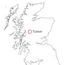

Tulloch, Scottish Highlands
Earlier remedial work, immediately north of the landslide, took place in 2010 when rock armour was placed above the track to stabilise a retaining wall. This was not related to any landslide event.
At 20.00 hours, this landslide caused the derailment of a goods train on the Crianlarich to Fort William line, causing the engine to fall down the embankment towards the loch.
BGS has no record of earlier slope failure on the eastern shore of Loch Treig. Since the railway opened in 1894 there is no record of disruption and historic Ordnance Survey maps do not show any evidence for slope failure.
The landslide was reported to the BGS on Monday 2 July and a visit was arranged by Network Rail for BGS landslide specialists to examine the event on Monday 9 July. By this time, while the failure scarp and pathway could be examined, the landslide debris had been cleared from the trackway and the track sleepers and rails were being relaid. The line reopened on Wednesday 11 July.
The landslide was initiated by a shallow planar movement that developed into a debris flow. The landslide event is recorded as BGS National Landslide Database ID 18683/1.
News reports
- Owners write off derailed locomotive due to costs news.scotsman.com, 10 February 2013
Geology
BGS mapping shows superficial deposits comprising till and morainic deposits on the loch side rising to a height of 350 m above OD on the hillside. These superficial deposits overlie the Loch Treig Schist and Quartzite bedrock, which is a metamorphic rock of Neoproterozoic age. There is little evidence for the presence of till in the vicinity of the backscarp, however, and the failure appears to have occurred in saturated soil and head containing cobbles and large (greater than 1 m diameter) boulders.
Landslide in summary
- The landslide of 28 June 2012 followed a period of heavy and prolonged rainfall. The area surrounding the backscarp was observed to be saturated with water.
- A small area of saturated superficial deposits failed and a shallow, translational slide took place.
- The slide moved downhill as a debris flow; mud-rich sediment and boulders were transported downslope onto the level ground forming the railway track.
- There is no record of earlier landslides in the vicinity of the railway along Loch Treig.
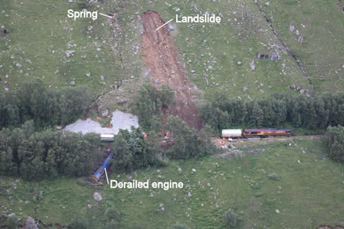
The landslide by Loch Treig, Argyll and Bute. Also seen is remedial work to a wall above the track carried out in 2010 (white rock armour above the blue derailed train). ‘Spring’ marks the smaller scarp mentioned in the text. Photograph used with permission of Route Asset Manager, Geotechnics Scotland.
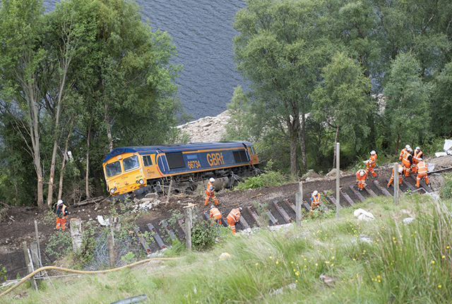
Derailed engine below the rail track. Photograph used with permission of Route Asset Manager, Geotechnics Scotland.
Backscarp
A landslide backscarp was examined on the western slope of Stob Coire Sgriodain. The backscarp is at an elevation of 325 m above OD and is roughly 15 m in width. Bedrock is not exposed within the scarp but is estimated to be within 1 m of the surface; detachment of material, therefore, is likely to have taken place close to the bedrock surface. The slide has excavated material to a length of roughly 20 m and forms a concave-upwards depression on the hillside.
A smaller scarp, 18 m to the north of the failure, was also examined. This feature comprised a 3 m-wide scar below which a narrow gully containing cobbles and boulders extended downslope for 20 m. The scarp was associated with running water and it appears that this feature is not the result of slope failure but rather a small spring, below which the fine-grained material had been washed away.
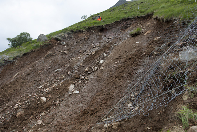
The Stob Coire Sgriodain landslide backscarp. BGS © UKRI.
Debris flow track
Below the backscarp, the debris flow track is roughly 20 m in width and extends down slope to the railway line. This pathway was marked by downslope-smoothed grass and scrub over which the debris passed. The pathway contained fragments of bedrock (metasedimentary schist and quartzite), including boulders, and was covered by a thin layer of reddened soil and head.
The majority of the debris from the landslide accumulated on the level ground forming the railway track some time before the evening of 28 June. It is understood from Network Rail that the derailment was caused by the train impacting a boulder, not from the quantity of debris on the track. A small number of boulders were observed in the trees 10 m below the level ground, but it is uncertain whether they were transported by the landslide event or removed during remedial work to restore the railway.
The lower parts of the pathway forming the railway cutting have been stabilised, fenced and netted. Tilt meters have been installed around the slide to detect any further movement and new drains have been installed.
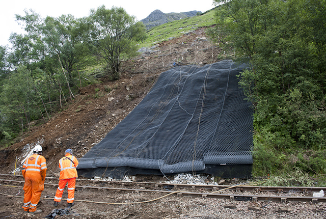
Debris pathway downslope, partly netted. Debris on the railway line has been cleared and the line is in the process of being repaired. BGS © UKRI.
You may also be interested in

Landslide case studies
The landslides team at the BGS has studied numerous landslides. This work informs our geological maps, memoirs and sheet explanations and provides data for our National Landslide Database, which underpins much of our research.

Understanding landslides
What is a landslide? Why do landslides happen? How to classify a landslide. Landslides in the UK and around the world.

How to classify a landslide
Landslides are classified by their type of movement. The four main types of movement are falls, topples, slides and flows.

Landslides in the UK and around the world
Landslides in the UK, around the world and under the sea.