A new open dataset to benefit onshore geoscience research
Data from deep onshore hydrocarbon wells is being released on an open access basis to help meet the UK’s net zero targets.
15/06/2023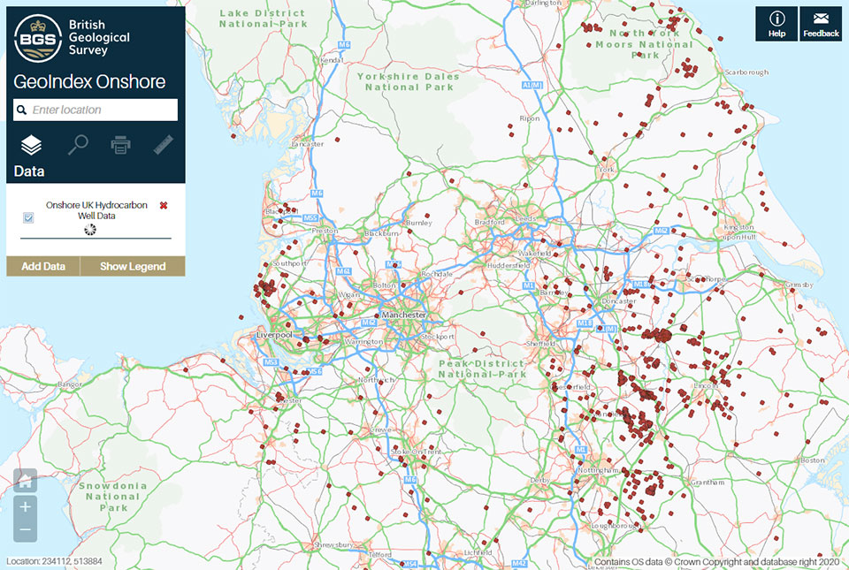

The North Sea Transition Authority (NSTA) has authorised the release of all the well data for onshore hydrocarbon boreholes held by BGS in the National Geoscience Data Centre (NGDC). Unlike borehole data from the North Sea, which has been available free of charge for some time, the data relating to these onshore boreholes was previously only available via data release agents. It is now available free of charge to industry, academics and the public via the BGS Geoindex, providing a new, free resource that will add to the knowledge necessary to meet net zero objectives.
Why is the data significant?
Few boreholes have been drilled to these depths (over 1 km) onshore in the UK and are almost exclusively a consequence of oil, gas or coal exploration. The oil and gas wells deeply penetrate the crust under the UK mainland and are geographically widespread across the UK.
Unlike coal wells, the oil and gas drilling data is better structured and better conforms to global standards of deep geological and deep geophysical data collection.
Most of the direct knowledge and samples that BGS has access to about the deep geology of the UK are based upon this data.
Why is the data being released?
Data from these deep hydrocarbon wells forms the best dataset to understand the geology of the deep UK subsurface. Widening access to the dataset could enhance the knowledge needed to meet net zero objectives:
- assessing the suitability of UK rocks for extraction of geothermal heat
- storing surplus energy from renewables and waste materials such as carbon dioxide
- identifying potential new mineral resources.
The data has been provided to BGS under regulation PON 9B, which sets out the records and samples requirements for onshore surveys and wells licensed by the NSTA. The data was previously held for BGS internal science use only, so this release widens the community of scientists who can access this important dataset. It includes the data for all boreholes that have been released (four years post-drilling) and for which BGS holds original geophysical data.
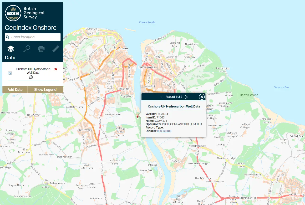
Example of onshore hydrocarbon well data on the BGS GeoIndex. Contains OS data © Crown Copyright and database right 2020
Data is being released using an Open Government Licence, which allows users to copy, publish, distribute and transmit the information, adapt the information and exploit the information commercially and non-commercially, provided that they acknowledge the source of the information.

The NSTA has collected data from more than 2200 onshore wells drilled in the search for oil and gas. Historically, half of that data were released through the British Geological Survey (BGS) with the rest provided by Data Release Agents on behalf of the NSTA. The new arrangement with the BGS means that all onshore hydrocarbon well data will be available from BGS. This free access to the unique onshore data will support the investment and innovation necessary to enable the ongoing energy transition.
Alan Poole, North Sea Transition Authority Geoscientist
BGS GeoIndex
The data is available via the BGS GeoIndex on a layer called ‘Onshore UK hydrocarbon well data’ and currently includes over 60 000 logs from 1200 wells and the number is still increasing. All related records in the BGS Borehole Index (which contains summary borehole metadata) have also been marked as open, releasing over 2000 records that were previously marked as confidential in the index.
About the authors

Andrew Kingdon
Head of BGS Digital Laboratories

Alison Steven
Data accession pipeline manager
Relative topics
Related news

Updated national 3D model will determine the depth to the solid bedrock beneath our feet
13/07/2026
The BGS Superficial Deposit Thickness Model now includes an elevation model of geological rockhead for the first time, providing important data for civil engineers, geoscientists and environmental scientists.

UK’s world-class research organisations launch new collective
10/07/2026
The launch of the National Research Organisations Group, brings together more than 100 leaders from government, research, industry and funding organisations, providing an authorativive voice on science, research policy and long-term investment.

Cheshire Geoenergy Observatory releases key geological datasets for UK thermal energy storage scheme design
09/07/2026
A new report and data packs from BGS will provide a unique resource for scientists working on the geology and hydrogeology of the Sherwood Sandstone Formation, an important aquifer and reservoir rock.

New geological mapping underway to help manage flooding along the River Tweed
08/07/2026
Scientists are surveying the Tweed catchment for the first time in over 100 years to enhance understanding of localised groundwater and improve flood forecasting.

Geological research in North Sea helping to safeguard subsea cables
06/07/2026
Subsea power and telecommunications cables are critical to the UK’s energy infrastructure and global connectivity, yet they remain vulnerable to damage from ship anchors, fishing activity and natural hazards.

UK Critical Minerals Intelligence Centre makes recommendations for the next UK criticality assessment
01/07/2026
CMIC has outlined the enhancements made to the next assessment update to ensure it is better tailored to the structure of the UK economy.

From archive to discovery: historical mineral reports support gold exploration in Scotland
25/06/2026
Digitised geological records show potential to unlock untapped mineral resources in Ardlochan, Argyllshire.

UK and Philippines scientists investigate natural hydrogen generation processes at atomic scale
22/06/2026
BGS researchers were granted access to use the Diamond Light Source facility in order to study hydrogen in light brighter than the sun.

Shortage of end-of-life materials presents challenge to UK critical minerals security
17/06/2026
A new report by the UK Critical Minerals Intelligence Centre reveals insufficient end-of-life material stocks present a supply risk over the coming decade, but offer significant long-term potential to meet critical mineral demand through recycling.

UK geothermal catalogue receives update
16/06/2026
BGS releases the second digital version of the UK geothermal catalogue of subsurface temperature and rock thermal conductivity measurements and heat flow calculations.

Scientists make new discovery in the history of the Giant’s Causeway
15/06/2026
New research is changing our scientific understanding of the formation of one of the UK’s most iconic landmarks and has revealed that Northern Ireland’s volcanic past occurred over a much shorter period than previously thought.

Latest research emphasises climate-related subsidence risk to millions of British homes
11/06/2026
New data from BGS highlights the projected future impact of warmer, drier summers and underlines the need for mitigation measures in susceptible regions.