BGS Earth Observation scientists have a long history (around 20 years) of working with interferometric synthetic aperture radar (InSAR) data. From a key role in the European Space Agency‘s pioneering Terrafirma project, via its spin offs (PanGeo; SubCoast) where early efforts were made at standardising geological outputs, all the way through to the present day where InSAR is routinely used to characterise UK shale gas sites, we have been at the forefront of its use.
The team not only develops understanding and interpretation of data but also helps develop algorithms that automatically process the vast amounts of satellite radar data now available and learn from this exciting data all over the world. To complement our in-house expertise, we now coordinate with experts at COMET to drive the development of InSAR techniques relevant to earthquakes and volcanoes.
Our research areas
Deformation monitoring is a key activity of the BGS as surface motion can be a crucial indicator of many natural and anthropogenic processes that can have significant impacts on lives and livelihoods.
The team has been working on characterising mine water rebound processes in the South Wales, Northumberland and Nottinghamshire coalfields. We have also used InSAR for the baseline monitoring of potential shale gas sites in the UK to assess the impact of hydraulic fracturing (‘fracking’) on ground stability.
In addition to work in the UK many of our international projects also use InSAR for geohazard research and monitoring.
- Monitoring of shale gas development sites
- Investigations of mine water rebound
- Groundwater abstraction rates
- Automatic InSAR processing and detection of significant motions
- Improving the InSAR signal
- Turning InSAR data into user relevant information
- European Ground Motion Service
Monitoring of shale gas development sites
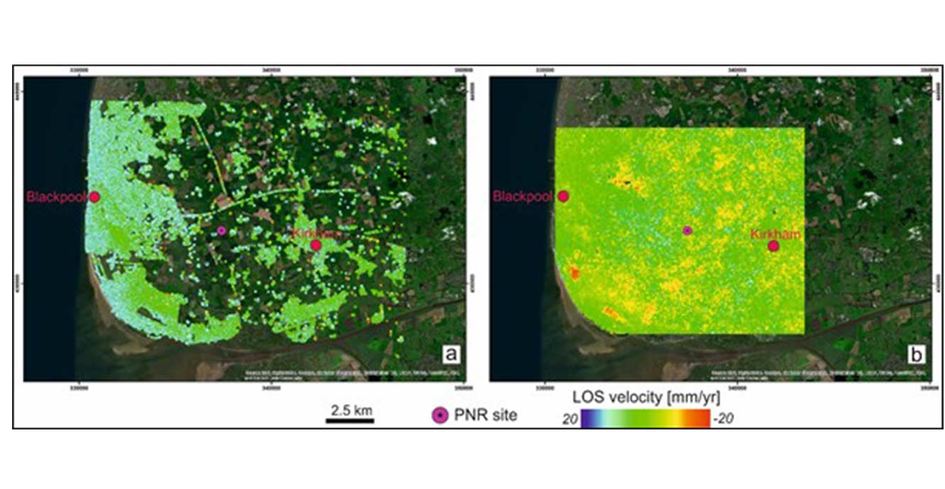

2015–2019 Fylde InSAR average velocities highlighting the Preston New Road site location. [a] RapidSAR Sentinel-1 ascending high resolution results; [b] Sentinel-1 ISBAS Sentinel-1 descending results. ISBAS data © Geomatic Ventures Limited 2019.
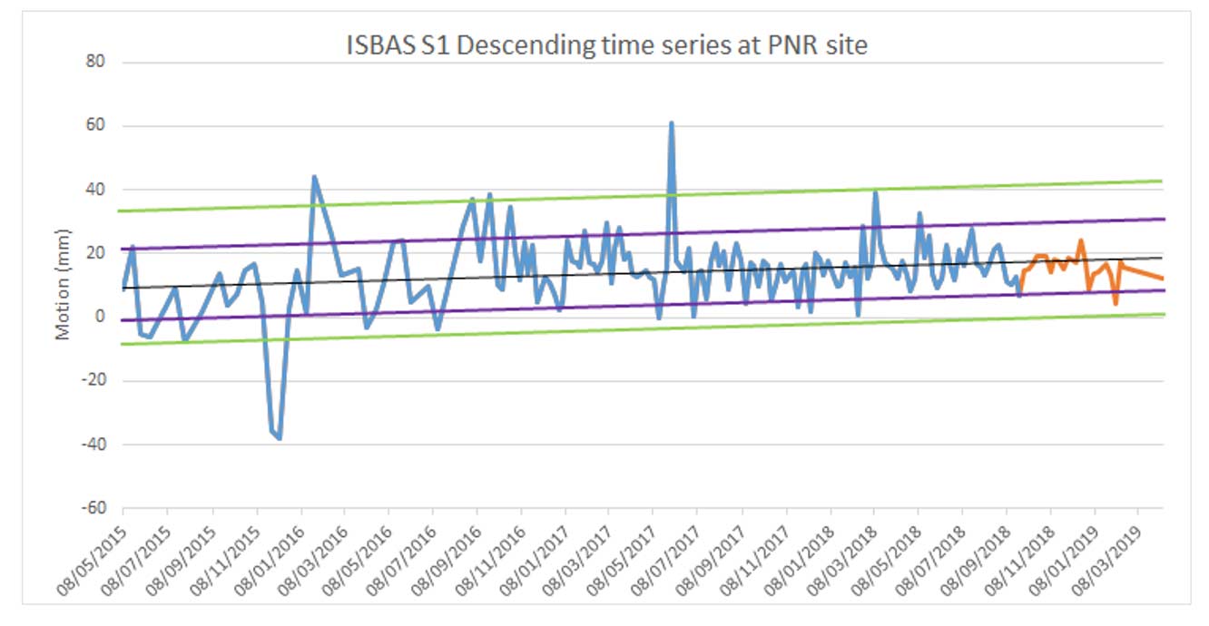
ISBAS time series for a measurement point over the Preston New Road site. The time series for the pre-fracturing baseline (blue line) and the continuation for the period of interest (orange line) are shown. The black trendline shows the average motion whilst the green lines mark the maximum and minimum deviations from the mean; the purple lines indicate one standard deviation from the average trend line. The ground motions observed following the hydraulic fracturing do not differ to the pattern of motion within the baseline period. Source: BGS © UKRI
Shale gas operations are contentious, with a degree of uncertainty regarding the effects that they may or may not have on the environment. One area of debate is whether operations could cause ground motion at the surface. This research monitored ground motion prior to operations and compared that baseline to the situation during and after shale gas operations.
The test sites are the Vale of Pickering (North Yorkshire) and the Fylde (Lancashire) in the UK. Hydraulic fracturing has only taken place at Lancashire as it was the only site to also get its hydraulic fracturing plan approved. We have applied different (InSAR) techniques to process archive and current satellite images to detect relative ground motion with millimetric accuracy in rural and semi-urban landcover.
The SBAS, ISBAS and RapidSAR processing for the period from 1992 to 2019 (extending 24 years prior to hydraulic fracturing) identified broad regions with little or no surface motion, along with discrete zones of uplift or subsidence. Analysis of the average velocities and time-series data revealed that the motion, where it occurred, related to factors including compressible ground, groundwater abstraction and underground coal mining. This research concluded that the shale gas operations in Lancashire did not alter the baseline ground motion dynamics to date, as detected by InSAR.
The successful application of InSAR for detecting and monitoring ground motion at shale gas sites in rural landcover in the UK, where radar coherence has traditionally been a major challenge, serves as a precedent for other regions where baseline monitoring is required.
Investigations of mine water rebound
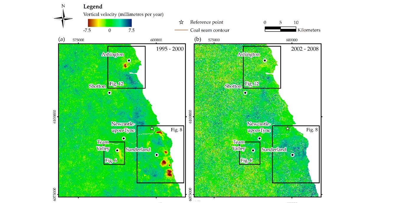
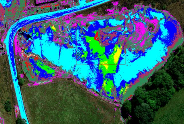
Figure 1A: InSAR-ISBAS average vertical velocities per different time spans: areas of subsidence during periods of active mining and water pumping 1995–2000.
(a) Areas of uplift as the mines close, pumping ceases and mine water moves back into the mined areas 2002–2008: from ENVISAT satellite.
(b) Areas of uplift as the mines close, pumping ceases and mine water moves back into the mined areas 2015–2016: from Sentinel-1 satellite.
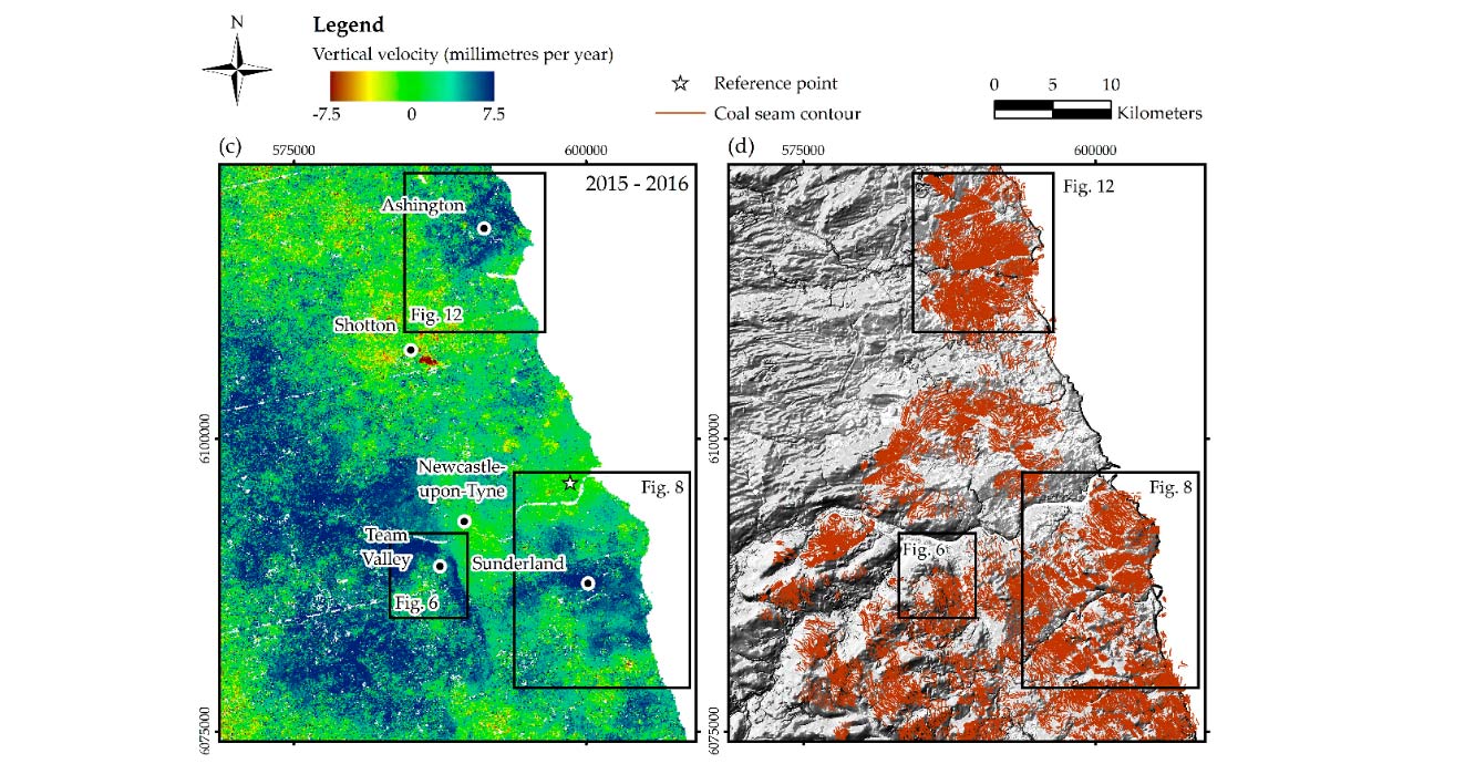
Figure 1B: InSAR-ISBAS average vertical velocities per different time spans: areas of subsidence during periods of active mining and water pumping 1995–2000.
(c) Coal seam contours.
(d) Topography.
Figure from Gee et al., (2017); InSAR data © Geomatic Ventures Limited 2016.
Coal mining and its legacy are one of the most prominent causes of ground motion in the UK. As such it is important to detect, monitor and understand the motion. We have been working with the University of Nottingham and the Mining Remediation Authority to understand this issue via the interpretation of InSAR data.
It is evident that active mining leads to subsidence and areas where mines have recently closed undergo uplift (see figures 1A and 1B). These motions are usually in response to groundwater and mine water level changes as the water is pumped out of an active mine and then flows back into a closed mine once the pumps are turned off. We have now built models that predict the amount of motion (uplift or subsidence) for a given geological succession and pumping history.
If we invert these models we can use the InSAR uplift signal to understand the mine water level changes. This has important implications for monitoring the water levels in the mines to ensure it does not reach the surface and cause pollution.
Groundwater abstraction rates
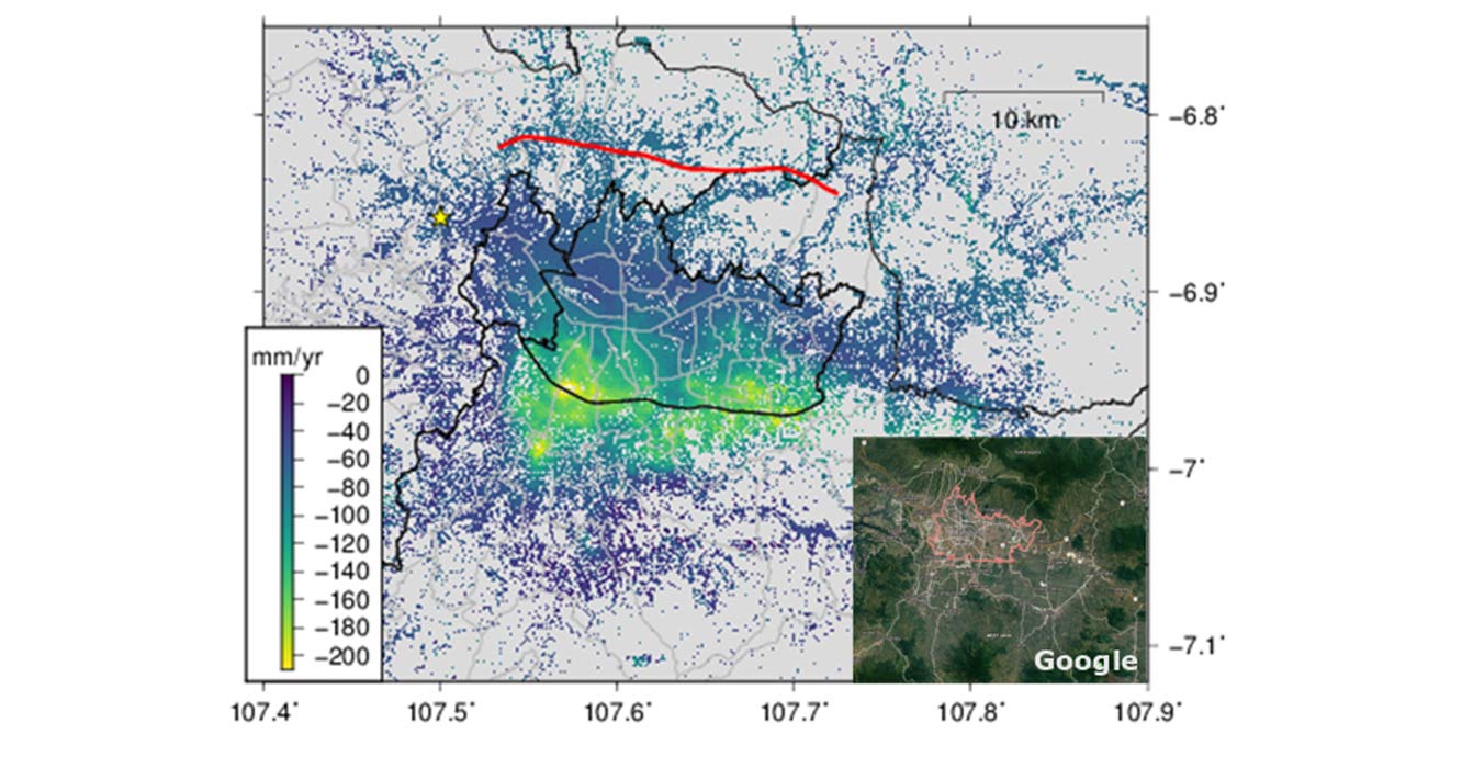
Ground subsidence across Bandung, Indonesia, measured using InSAR. The maximum subsidence rate exceeds 20 cm per year in some areas! Source: BGS © UKRI
The booming economies of many low- to middle-income nations, coupled with increasing density of people living and working in urban areas, is putting tremendous strain on the natural resources of cities. Intensive groundwater pumping for agricultural activity, industry and supplying the needs of people is depleting groundwater reserves and has led to dramatic levels of subsidence in many cities.
We are measuring this ground subsidence using InSAR in Indonesia (Bandung) and Vietnam (Hanoi) and, together with innovative modelling, we are trying to quantify groundwater extraction rates. This will help us to better understand the long-term sustainability of groundwater aquifers beneath these cities.
Automatic InSAR processing and detection of significant motions
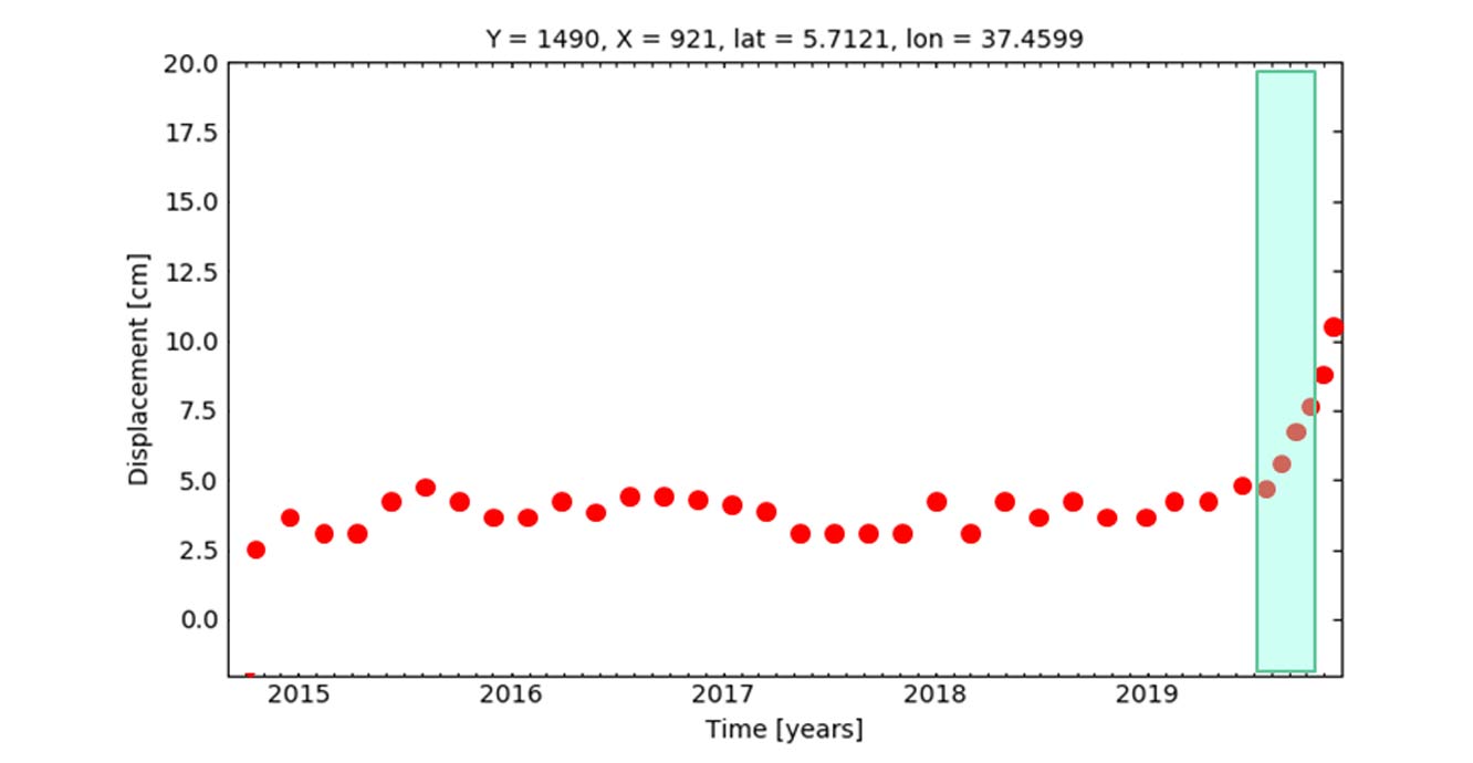
A synthetic example of an anomalous change detection in InSAR-derived time-series information. Once such changes are detected, our system will raise various levels of warnings and alerts. Source: BGS © UKRI
We are developing an InSAR processor for the Sentinel-1 radar satellite constellation that is able to automatically download, process and update all the data from this satellite over a specified region. As part of this initiative we are developing automatic methods to classify the InSAR time series into the different patterns of motion and automatically recognise when anomalous motions occur in near-real time. These tools make InSAR more accessible and the information locked within the datasets more useable.
Improving the InSAR signal
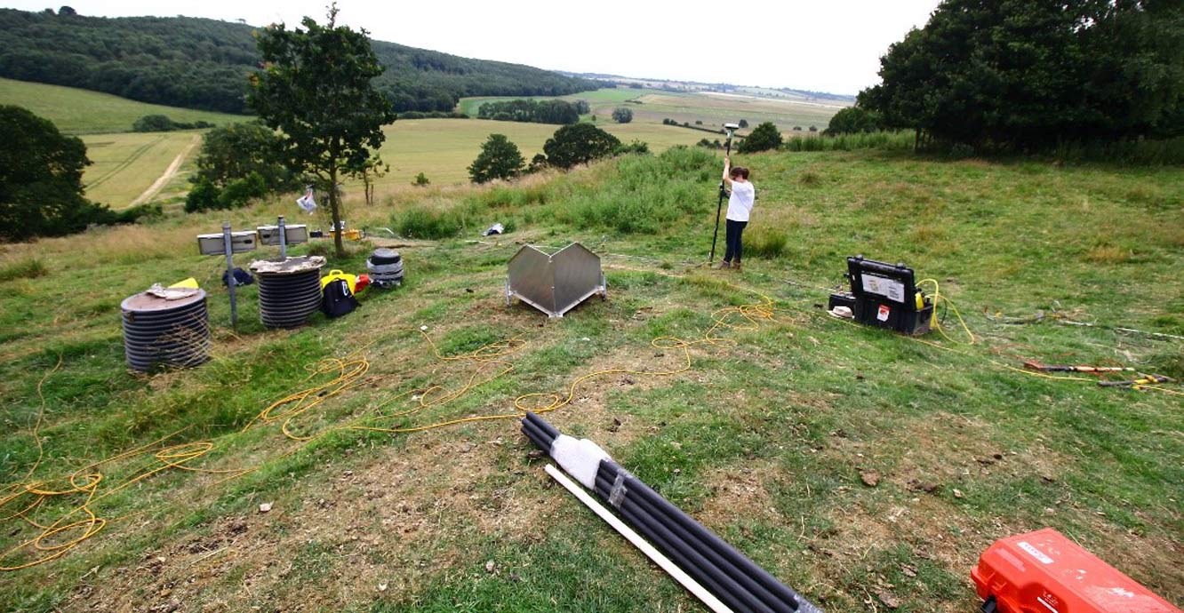
Installation of a passive radar reflector at Hollin Hill, Yorkshire. Source: BGS © UKRI
As part of our efforts to provide cutting-edge research, we deploy passive and active radar reflectors to support SAR data processing in vegetated areas that do not show sufficient temporal phase stability otherwise. Some of these radar targets are already installed or are going to be installed soon over the UK Geoenergy Observatories sites and across BGS research facilities such as Hollin Hill and Herstmonceux.
Turning InSAR data into user relevant information
We add value to InSAR data through integration with relevant datasets to generate new BGS information products.
The purpose of the property subsidence assessment dataset is to provide information on ground movement (predominately due to shrink–swell) across Great Britain for the property report and insurance sectors.
The dataset builds upon the GeoSure datasets specifically for shrink–swell hazards with the property report and insurance sectors in mind. It combines the geological understanding of shrink–swell with factors that might augment the severity of the hazard, such as building foundation depth and proximity to trees.
The result is a building-specific hazard score. This hazard score is then adjusted by observed changes in ground motions, which are derived from the InSAR time series; in this way we are able to identify which are the most susceptible properties and then highlight when they are undergoing significant measured motion.
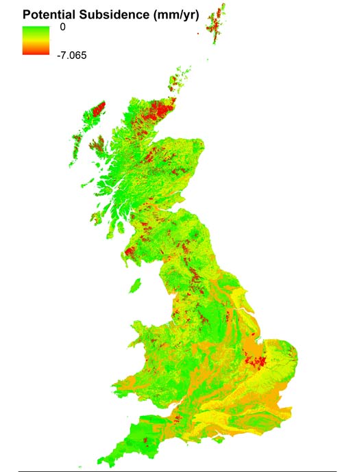
The potential subsidence rates dataset for the UK builds upon the BGS Geology 1:50 000-scale data to offer the maximum rates of motion (mm per year) that a geological deposit could undergo, under ideal conditions, as a result of natural processes. This is the result of joint working between engineering geologists and Earth observation geologists to not only rate how susceptible a lithology is to motion but also to identify a rate of motion from the geological interpretation of InSAR datasets.
This product was originally developed for coastal lowland areas to help understand the link between subsidence and sea level rise, but it is also useful for the property and construction industries.
European Ground Motion Service
A new Copernicus Land Monitoring Service is underway to produce a European-wide ground motion service. This ambitious service, funded by the European Environment Agency, will process InSAR data for the whole of Europe to produce a free-to-use, harmonised ground-motion map.
A product such as this requires careful planning, so during the first phase a team are working on the detailed specification. The BGS has been invited to be on the Ground Motion Advisory Board (GMAB), meaning we are part of a European team responsible for reviewing the specification and production plans before they go out to tender.
Once processing is underway the GMAB will also be responsible for the review of the product, its production status and plans for the future. This is a prestigious position for the BGS and has been made possible through 15 years of European Union and European Space Agency work.
You may also be interested in:
Geodesy and Earth observation
Developing and using innovative Earth observation techniques to characterise and monitor Earth processes that affect lives and livelihoods.
Hyperspectral research
The BGS has extensive experience acquiring and processing hyperspectral data for a range of geological applications.
Footnotes
1. (2017)
Gee, D., Bateson, L., Sowter, A., Grebby, S., Novellino, A., Cigna, F., Marsh, S., Banton, C. and Wyatt, L., 2017. Ground motion in areas of abandoned mining: application of the intermittent SBAS (ISBAS) to the Northumberland and Durham Coalfield, UK. Geosciences, 7(3), p.85. https://doi.org/10.3390/geosciences7030085