We have extensive experience acquiring and processing hyperspectral data for a range of geological applications, from detecting mine waste in the UK to mapping lava flow evolution in Ethiopia.
Hyperspectral data is acquired by sensors that record data for hundreds to thousands of electromagnetic wavelengths as individual bands. The imagery we use for Earth observation (EO) is acquired by aircraft or satellites, typically measuring bands of reflected radiation between 350 and 2500 nm covering the visible to the short wave infrared region of the electromagnetic spectrum (Figure 1). Each pixel in the imagery has its own spectrum, which allows us to determine the mineralogy. Many useful minerals have absorption features in the hyperspectral data, so minerals can be mapped remotely. We have a range of laboratory and field spectrometers to collect in situ spectra, to calibrate the airborne and satellite measurements.
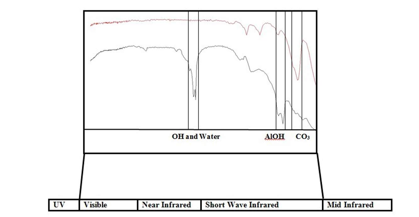

Figure 1: visible to short-wave infrared region of the electromagnetic spectrum, with positions of absorption bands for kaolinite and calcite (adapted from Spectral Interpretation Field Manual, AusSpec International). Source: BGS © UKRI
Mine waste maps
Hyperspectral airborne data can be used to produce mineral maps, especially where ground spectrometer measurements can be collected for calibration. We can also use this type of data to map mine waste and acid mine drainage at active and abandoned mine sites.
Mine waste contains complex mixtures of minerals, so ground spectral data of these mixtures is important to help classify the minerals in a site’s mine waste. Pure minerals can be identified using spectral libraries such as the USGS and JPL spectral libraries, where pure minerals have been measured spectrally in the laboratory to provide reference spectra for mineral identification, either on the ground or using remote sensing data.
We have undertaken several projects using hyperspectral data to map the distribution of mine waste in various locations around Europe, South Africa and elsewhere. In the UK we have worked in Cornwall, at Parys Mountain (a large copper mine on Anglesey), the lead mining region of mid-Wales and the lead and zinc mining region in the Pennines.
As an example, the MINEO project that was carried out by several European geological surveys (BGS, BGR, BRGM, GEUS, GTK and LNEG) acquired HyMap hyperspectral airborne data over seven mine sites around Europe. The aim of the project was to look at mine waste, rather than mineral exploration, in a populous, temperate environment. The project used the hyperspectral airborne data to produce various mine waste maps.
Extensive field work was also undertaken in order to calibrate the airborne data and also for validation of the results. Figure 2 shows an example of one of the mine waste maps over the tailings dam of the Wheal Jane mine in Cornwall. The various minerals are represented with different colours on the map.
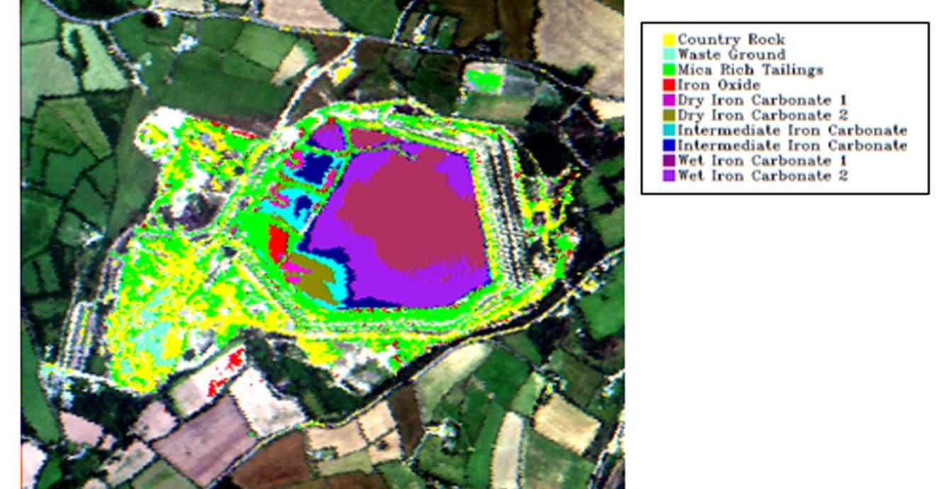
Figure 2: mine waste map of the tailings dam at Wheal Jane mine, Cornwall, from the MINEO project. Source: BGS © UKRI
Contaminated land
We are currently leading a project called ‘Remote Sensing for contaminated land management in Wales and England’ for Defra, the Welsh Government and Natural Resources Wales. The project focuses on two mines in the lead mining region of mid-Wales and one mine in the lead and zinc mining region in the Pennines.
The team, which includes 2Excel Geo, collected airborne hyperspectral data alongside drone-mounted thermal data and stereo air photos. Hyperspectral airborne data was acquired in the summer of 2019 and thermal and stereo drone data was acquired in November 2019. We are creating maps of possible seepages of mine water into water systems and estimations of the volume of mine waste present. The hyperspectral data acquired for this project is much finer spatial scale (30 to 60 cm) compared to previous projects (3.5 to 4 m).
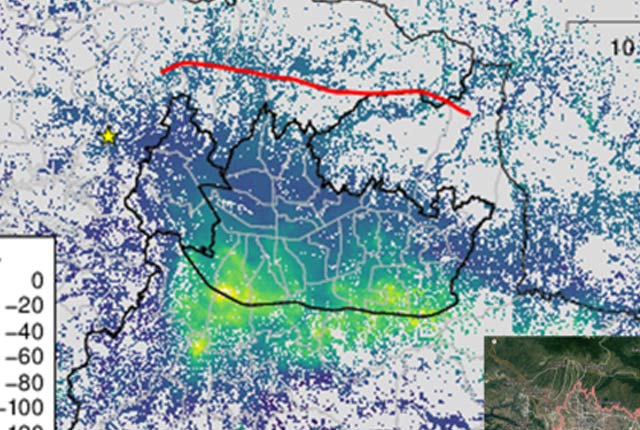
Spectrometer measurements and rock samples have also been taken in Wales and the Pennines (figures 3 and 4). This is very important for ground truthing and for verification of the classification results. Accurate GPS measurements have been taken for the sample locations and the drone survey ground control.
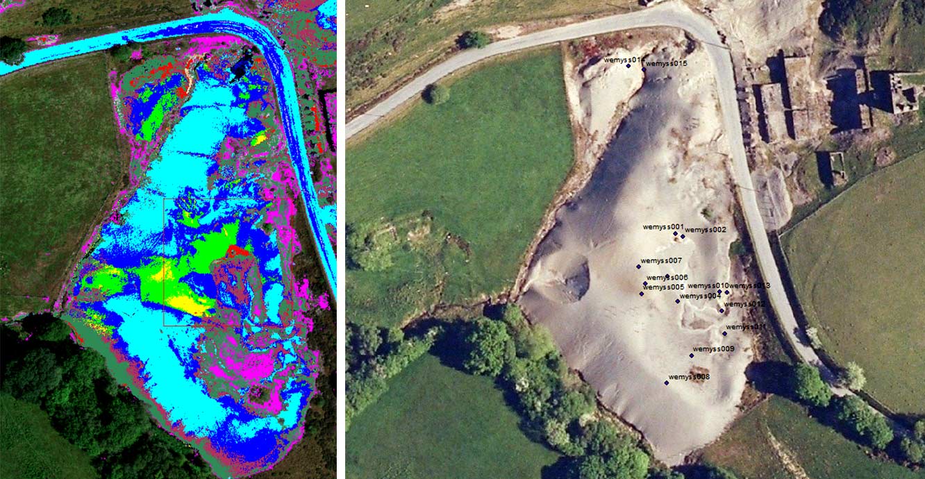
Figure 3 (left): an example of mine waste mapping at one of the mid-Wales mine sites, with the red pixels potentially indicating the most zinc- and lead-rich tailings at the site.
Figure 4 (right): GPS locations of mine waste samples gathered for XRF and XRD analysis.
Source: BGS © UKRI
BGS field and laboratory spectrometers
We have a range of laboratory and field spectrometers to collect in situ spectra to calibrate the airborne and satellite measurements. They include:
- portable infrared mineral analyser (PIMA)
- ASD FieldSpec
- Quality Spek Trek
We have recently purchased an ASD QualitySpec Trek Visible to SWIR (NIR) handheld spectrometer. This spectrometer measures reflected radiation from the visible to the shortwave infrared region of the electromagnetic spectrum in order to detect minerals with absorption features in that region of the spectrum. These measurements can be easily taken in the field using the QualitySpec Trek due to its hand-held and cable-free system (Figure 5).
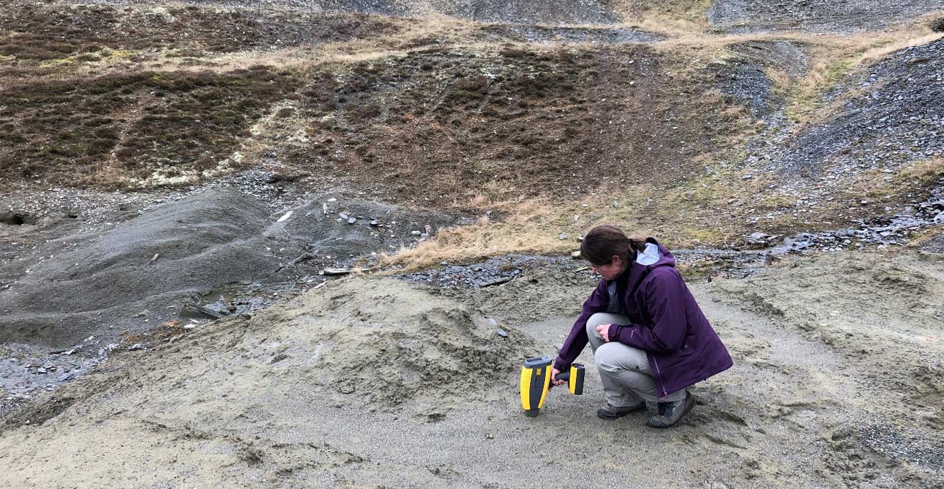
Figure 5: using the Quality Spec Trek in the field. Source: BGS © UKRI
You may also be interested in:

Geodesy and Earth observation
Developing and using innovative Earth observation techniques to characterise and monitor Earth processes that affect lives and livelihoods.
InSAR research
BGS Geodesy and Earth Observation scientists have a long history of working with InSAR data.