The BGS GeoClimate shrink–swell national datasets show potential change in subsidence susceptibility due to changes in climate. They have been developed by combining long term UK Climate Projection (UKCP) scenarios for rainfall and temperature changes with the geotechnical properties of the ground, to identify areas projected to experience the largest increases in susceptibility to subsidence over the next century.
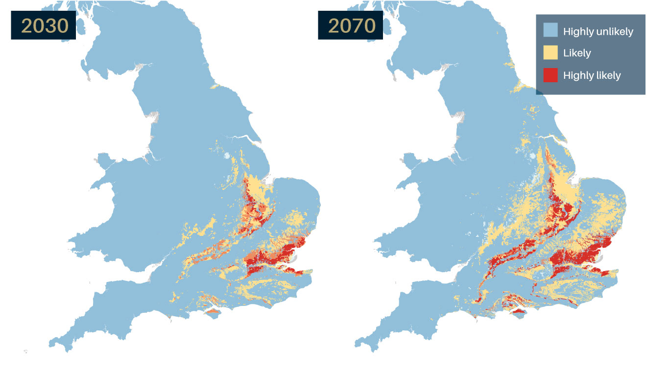

GeoClimate UKCP18 2030 and 2070 projections showing potential change in shrink-swell subsidence susceptibility due to changes in climate. BGS © UKRI – Contains Ordnance Survey data © Crown copyright and database right 2022

It is estimated that shrink-swell ground movement, typically reported as subsidence, has cost the economy an estimated £3 billion over the past decade. © National Trust Images/John Hammond.
Shrink–swell ground movement can lead to financial loss for anyone involved in the construction, ownership or management of property, large structures, infrastructure networks and the utilities. BGS © UKRI.
Many soils contain clay minerals that absorb water when wet (making them swell) and lose water as they dry (making them shrink). This ‘shrink–swell’ behaviour is controlled by the type and amount of clay in the soil and by changes in soil moisture content related to rainfall and local drainage. This shrink–swell variation can cause ground movement, which in turn may affect building foundations, pipes or utility services.
Dry weather and high temperatures are a major factor in the emergence of subsidence in clay soils. Every summer can be completely different to the last; summer 2018 had the hottest, driest June for years whereas summer 2019 had one of the wettest Junes on record. Warmer, drier summers and increases in annual temperature and rainfall variability are predicted, which will cause more shrink–swell activity.
Shrink–swell ground movement, typically reported as subsidence, is one of the most damaging geohazards in Britain today, costing the economy an estimated £3 billion over the past decade. It can lead to financial loss for anyone involved in the construction, ownership or management of property, large structures, infrastructure networks and the utilities. These costs could include increased insurance premiums, depressed house prices and, in some cases, engineering works to stabilise land or property.
Armed with knowledge about potential hazards, preventative or mitigative steps can be put in place to alleviate the effects of the hazard on property and infrastructure. The cost of such prevention may be very low and is often many times lower than the repair bill following ground movement.
GeoClimate: shrink–swell national datasets

The BGS GeoClimate: shrink–swell national datasets show potential change in subsidence due to changes in climate.
BGS has developed a suite of products, including maps and data, which show potential change in subsidence due to UKCP climate change scenarios.
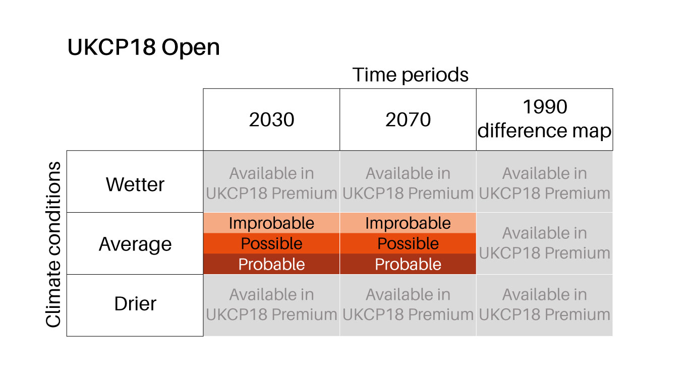
GeoClimate UKCP09 Open is provided for three time periods, 2030s, 2050s and 2080s, with one projection provided for each time period based on the average outcome for the UKCP09 medium emissions scenario and the most susceptible GeoSure value (worst case) within the grid cell.
GeoClimate UKCP09 Premium is a quasi-1:50 000-scale product, provided as area polygons, for five time-period envelopes of 2020, 2030, 2040, 2050 and 2080. It is based on the medium emissions scenario and provides projections for average, wetter and drier climate conditions, describing five categories of projected susceptibility, from highly unlikely to extremely likely.
GeoClimate UKCP18 Open is provided for two time periods, 2030s and 2070s, with one projection provided for each time period based on the average outcome for the UKCP18 higher emissions scenario and the most susceptible GeoSure value (worst case) within the grid cell.
GeoClimate UKCP18 Premium is a quasi-1:50 000-scale product, provided as area polygons, for two projected 11-year windows of 2030 and 2070. It is based on the UKCP18 higher emissions scenario and provides projections for average, wetter and drier climate conditions, describing five categories of projected susceptibility, from highly unlikely to extremely likely.
Summary of GeoClimate UKCP18 Open dataset content. BGS © UKRI.
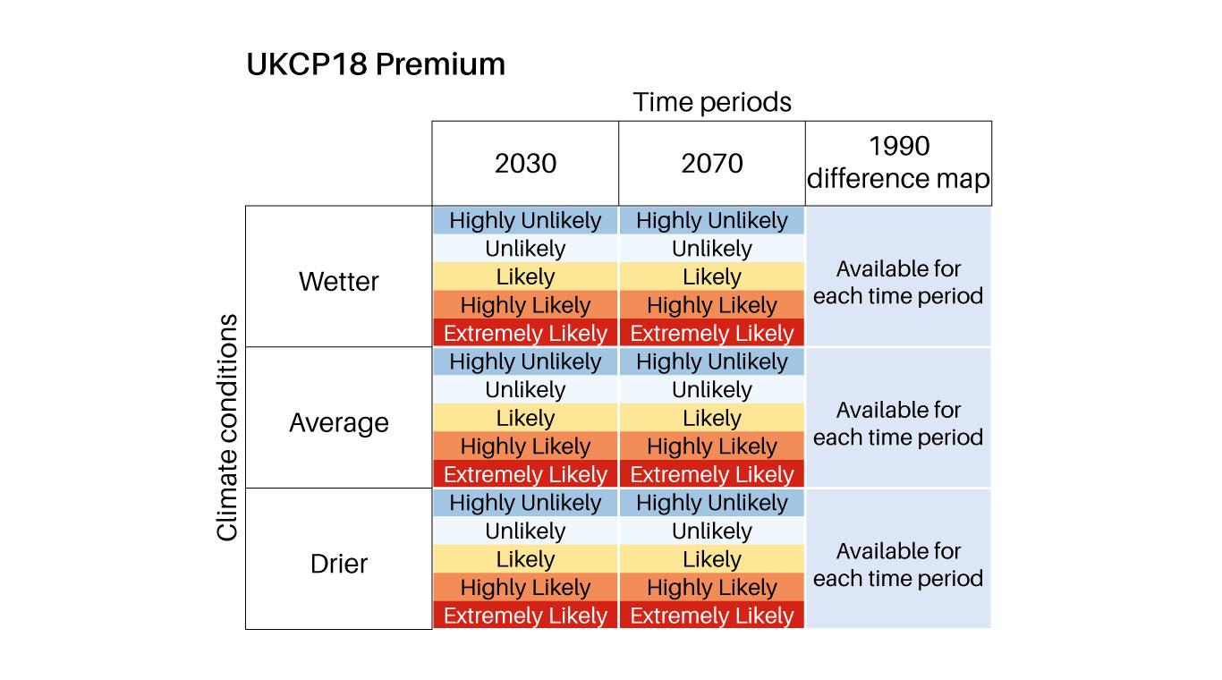
Summary of GeoClimate UKCP18 Premium dataset content. BGS © UKRI.
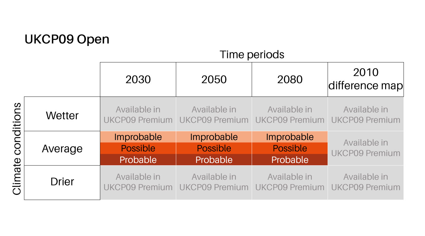
Summary of GeoClimate UKCP09 Open dataset content. BGS © UKRI.
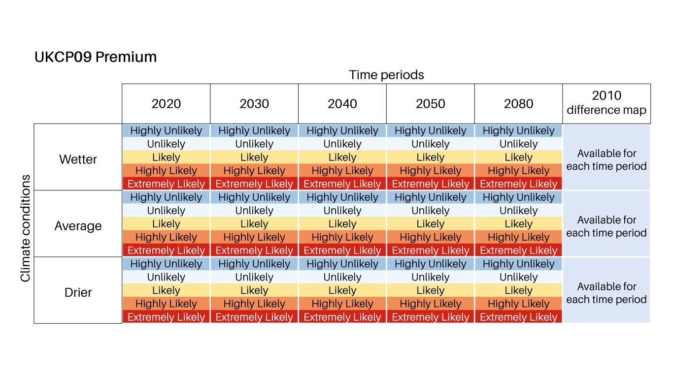
Summary of GeoClimate UKCP09 Premium dataset content. BGS © UKRI.
GeoClimate data products
GeoClimate UKCP18 Open
Based on higher emissions scenario, provides the most susceptible value for the time periods 2030s and 2070s within the grid cell.
GeoClimate UKCP18 Premium
Based on higher emissions scenario, provides five levels of susceptibility for average, wetter and drier climate conditions for the time periods 2030s and 2070s at the 1:50 000 area polygons scale.
GeoClimate UKCP09 Open
Based on medium emissions scenario, provides the most susceptible value for the time periods 2030s, 2050s and 2080s within the grid cell.
GeoClimate UKCP09 Premium
Based on medium emissions scenario, provides five levels of susceptibility for average, wetter and drier climate conditions for the time-period envelopes of 2020, 2030, 2040, 2050 and 2080 at the 1:50 000 area polygons scale.
Further information about the shrinking and swelling of soils:
What is shrink-swell?
Many soils contain clay minerals that absorb water when wet (making them swell) and lose water as they dry (making them shrink). This ‘shrink–swell’ behaviour is controlled by the type and amount of clay in the soil and by changes in soil moisture content related to rainfall and local drainage. This shrink–swell variation can cause ground movement, which in turn may affect building foundations, pipes or utility services.
How does climate change affect shrink-swell?
Dry weather and high temperatures are a major factor in the emergence of subsidence in clay soils. Every summer can be completely different to the last; summer 2018 had the hottest, driest June for years whereas summer 2019 had one of the wettest Junes on record. Warmer, drier summers and increases in annual temperature and rainfall variability are predicted, which will cause more shrink–swell activity.
What is the impact of shrink-swell?
Shrink–swell ground movement, typically reported as subsidence, is one of the most damaging geohazards in Britain today, costing the economy an estimated £3 billion over the past decade. It can lead to financial loss for anyone involved in the construction, ownership or management of property, large structures, infrastructure networks and the utilities. These costs could include increased insurance premiums, depressed house prices and, in some cases, engineering works to stabilise land or property.
Armed with knowledge about potential hazards, preventative or mitigative steps can be put in place to alleviate the effects of the hazard on property and infrastructure. The cost of such prevention may be very low and is often many times lower than the repair bill following ground movement.
Frequently asked questions
Whereas GeoSure: shrink–swell considers only the physical properties of the geology, GeoClimate considers how these physical properties may be affected in the future as a consequence of projected changes in climate according to UKCP09 and UKCP18.
The GeoSure: shrink–swell rating does not change for a geological deposit. However, the projected changes in climate vary across Great Britain and, therefore, the GeoSure: shrink–swell rating letter is combined with a number that represents the ‘dry days’ projected for that area, to provide a GeoClimate rating.
The ‘difference’ maps (based on the time period 2005–2015) can be used to identify potential change from current ‘modelled’ conditions.
Where users are interested in ‘current climatic conditions’, UKCP18 provides a baseline dataset (based on the time period 1985–1995), which should be referred to.
GeoClimate Open data has been generated at 1:400 000 scale and is intended to be used as a national overview. It has been derived from the GeoClimate Premium dataset by taking the ‘worst-case’ susceptibility classification for each grid cell, and is therefore not suitable for local assessments.
GeoClimate Premium has been developed at quasi-1:50 000 scale (due to the variable scales of input data) to provide a more detailed assessment of variations in clay shrink–swell susceptibility due to climate change. It is recommended for more detailed, local assessments.
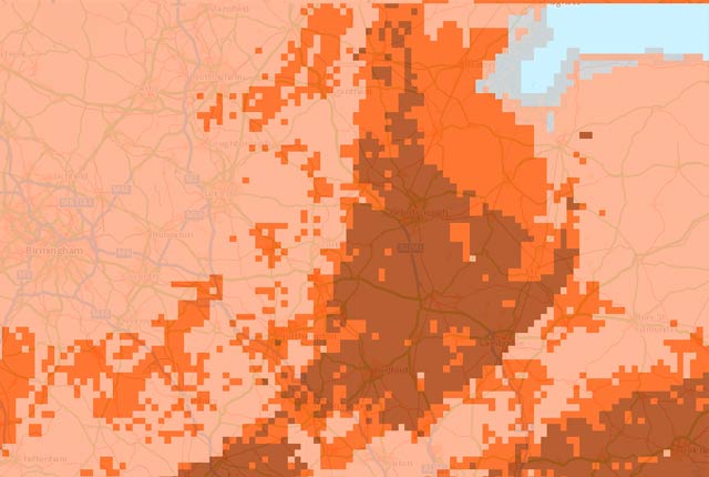
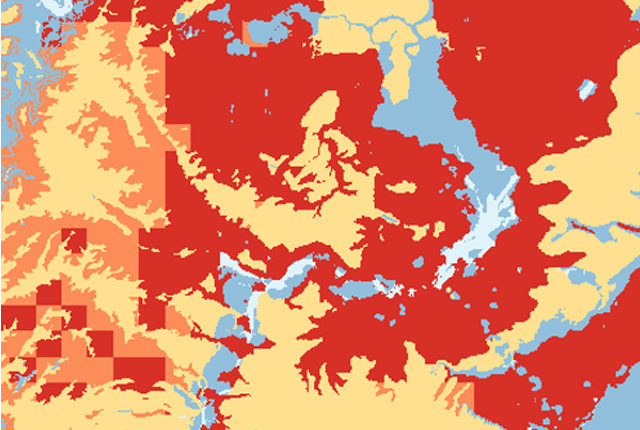
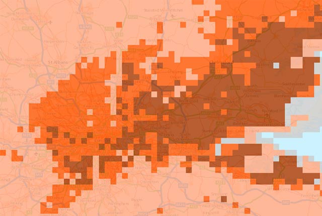
For a visual comparison of the two datasets, figures 1A and 1B demonstrate the difference of GeoClimate Premium and Open for an area in the south-east of Great Britain at a 40 km2 area, whilst figures 2A and 2B demonstrate the increased resolution provided by GeoClimate Premium in comparison to GeoClimate Open for a 2 km2 area.
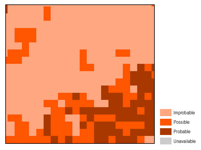
Figure 1A: GeoClimate Open for an example 40 km2 area in south-east Great Britain. BGS © UKRI.
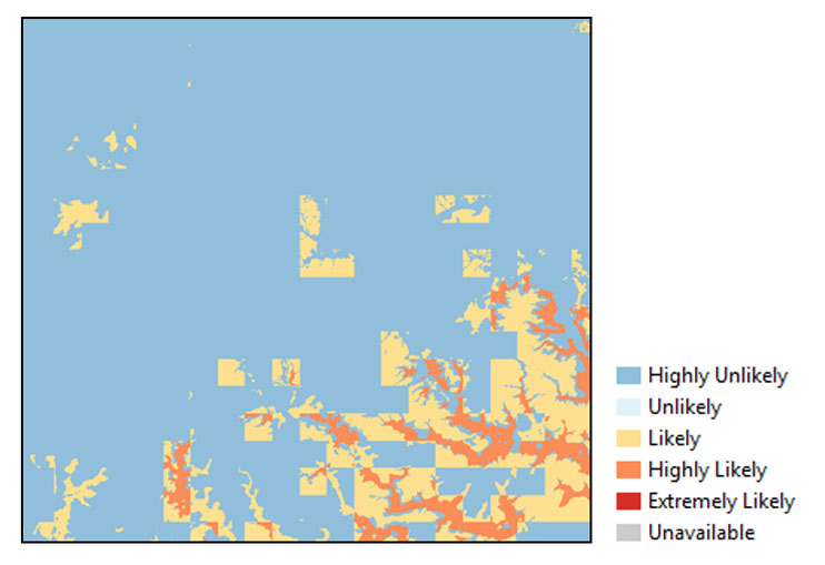
Figure 1B: GeoClimate Premium for an example 40 km2 area in south-east Great Britain. BGS © UKRI.
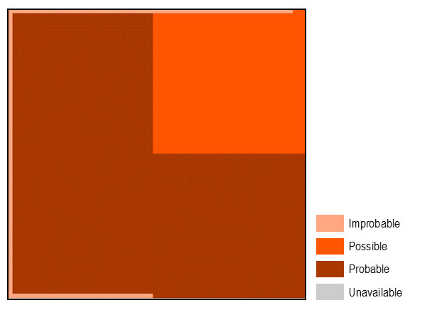
Figure 2A: data resolution of GeoClimate Open for an example 2 km2 area in central Great Britain. BGS © UKRI.
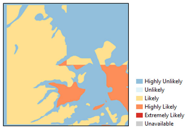
Figure 2B: data resolution of GeoClimate Premium for an example 2 km2 area in central Great Britain. BGS © UKRI.
GeoClimate UKCP09 is the first BGS product to look at the effects of climate change on geohazard susceptibility. It uses the UK Climate Projections 2009, developed under the Met Office Hadley Centre Programme, as they provided the most suitable assessment of how the UK climate may change over the 21st century. At the time of production, they were the state-of-the-art in climate projections available. GeoClimate UKCP09 utilises the UKCP09 medium emissions projections.
GeoClimateUKCP18 utilises the UKCP18 Convection Permitting Model climate projections for the UK at 2.2 km resolution. These were produced using the Met Office HadGEM3-GC3 model and are better able to represent small-scale atmospheric processes (e.g. large convective storms) than regional climate models run on a coarser resolution. The projections consist of a 12-member ensemble forced with the highest greenhouse gas concentration and emissions pathway (RCP8.5).
For further details of UKCP18 compared to UKCP09, please see the Met Office official document.
GeoClimate UKCP09 is based on the UKCP09 medium emissions scenario.
UKCP18 utilises the updated UKCP climate scenario, UKCP18, using the 2.2 km local projections (Murphy et al., 2018) to ensure the resolution provided in GeoClimate UKCP09 is maintained. These UKCP18 higher-resolution projections were provided for only one scenario, RCP8.5. Although RCPs are not strictly the same as emissions scenarios, RCP8.5 should be considered to be comparable to the high emissions scenario.
The UKCP18 clearly outlined that general climate change trends over land for the 21st century were broadly consistent with UKCP09 projections; both show increased chance of milder, wetter winters and hotter, drier summers.
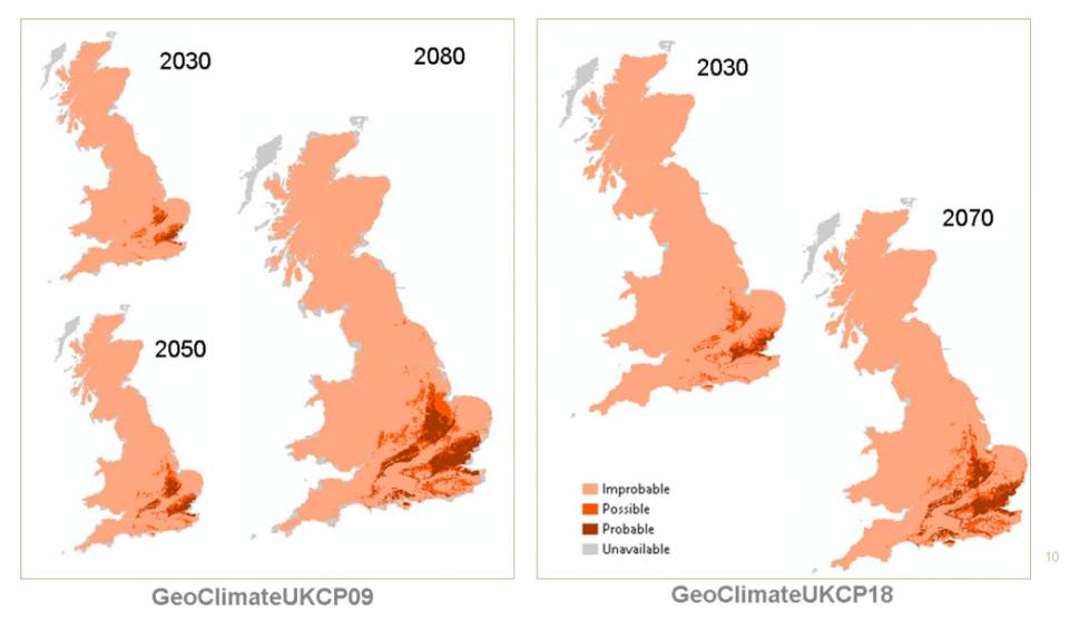
A comparison of GeoClimate UKCP09 Open and GeoClimate UKCP18 Open outputs. BGS © UKRI.
Therefore, GeoClimate UKCP09 and GeoClimate UKCP18 vary due to advancements in climate modelling and the use of a higher emissions scenarios in GeoClimate UKCP18.
For further details of UKCP18 compared to UKCP09, please see the Met Office official document.
This is a comparison of GeoClimate UKCP09 and GeoClimate UKCP18 Premium.
| GeoClimateUKCP09 Premium | GeoClimateUKCP18 Premium | |
|---|---|---|
| Time slices available (11-year window) | Five: 2020 (2015–2025); 2030 (2025–2035); 2040 (2035–2045); 2050 (2045–2055); 2080 (2075–2085) | Two: 2030 (2025–2035); 2070 (2065–2075) |
| Historical time period (11-year window) | 2010 (2005–2015) | 1990 (1985–1995) |
| Emissions scenario | Medium emissions | Higher emissions (8.5) |
| Climate models | 11 regional climate models (UKCEH) | 12 representative concentration pathways |
| GeoClimate ategories | 5 | 5 |
| Climate data scale | Daily 2 km grid | Daily 2.2 km grid |
| Statistical outputs | Medium, drier and wetter for each scenario projection (18) | Medium, drier and wetter for each scenario projection (9) |
| Format | ESRI vector polygon data | ESRI vector polygon data |
| Difference maps | 15 — three for each time slice | 6 — three for each time slice |
Changes in susceptibility are driven by both the mineralogical and lithological characteristics of the geology as well as climate. Some areas of the country will never experience clay shrink–swell due to the underlying geology and these areas remain ‘improbable’ in every time period. In other areas, the underlying geology contains clay minerals that can shrink and swell due to the presence of water, but are not yet experiencing fluctuations large enough to trigger visible volume change and ground movement. As climate changes over time, and the water content in the ground reaches new extremes, it is likely that these areas will experience some ground movement.
As the climate continues to change, more geological formations containing shrink–swell-susceptible clay minerals will experience larger fluctuations in water content. This will lead to the area projected to experience rising susceptibility becoming more widespread.
You can use GeoClimate Open to check for any modelled change over the time periods. If it is consistently ‘improbable’ that your area of interest will experience changes in shrink–swell susceptibility, then GeoClimate Open provides all the information you require to consider the impact of climate change on clay shrink–swell. You should, however, consult BGS GeoSure: shrink–swell to identify the existing susceptibility.
If however, you do see a change to the susceptibility over time, then you are then advised to look more closely and use the detailed premium data or get site-specific advice.
The methodology for UKCP09 Premium provides 11 values for each grid square, originating from the use of the UKCEH 11 regional climate models. The tenth percentile has been utilised to represent the wetter conditions; the fiftieth percentile represents median average conditions and the ninetieth percentile represents drier conditions.
The methodology for UKCP18 Premium provides 12 values for each grid square, originating from the use of a 12-member perturbed parameter ensemble of global climate simulations. The tenth percentile has been utilised to represent the wetter conditions; the fiftieth percentile represents median average conditions and the ninetieth percentile represents drier conditions.
The reason for the ‘unavailable’ category arises from two different sources. Firstly, bot all the input datasets required are available for the Scottish Islands (including Orkney and Shetland). Therefore, results for these areas are categorised as ‘Input datasets unavailable’.
Secondly, during the data processing, extremely high outlying values of soil moisture deficit were observed. Those events were associated with the coastline and originate with the UKCP09 and UKCP18 climate scenarios data. To account for this, any grid point with extremely high soil moisture deficit values was removed and replaced with a null value. It is therefore not possible to provide a GeoClimate score and the cell is recorded as ‘unavailable’.
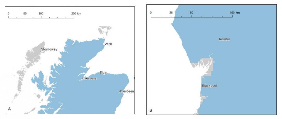
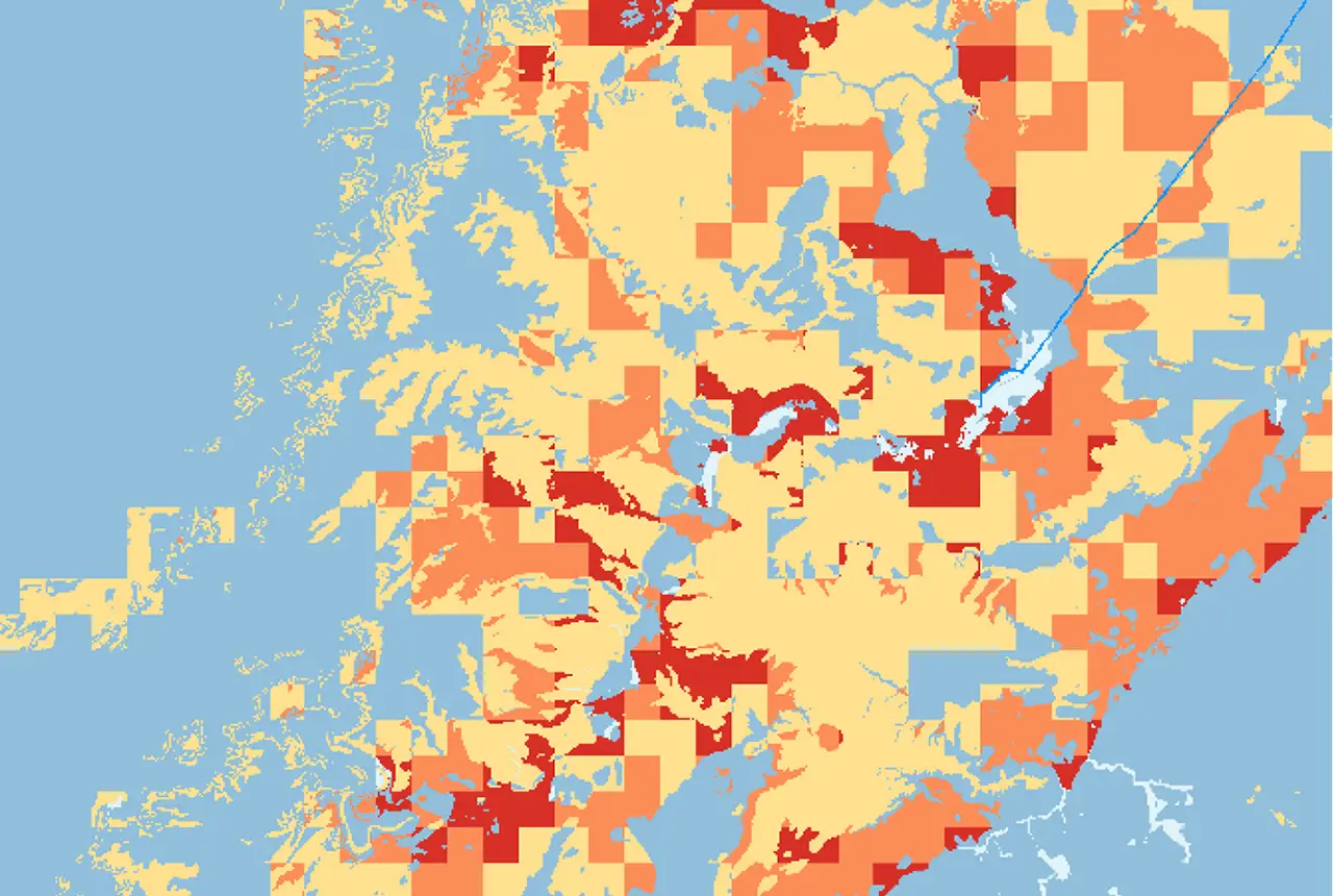
GeoClimate Premium of a) the Outer Hebrides and b) Morecambe Bay, demonstrating the two origins of data unavailable areas (grey). BGS © UKRI.
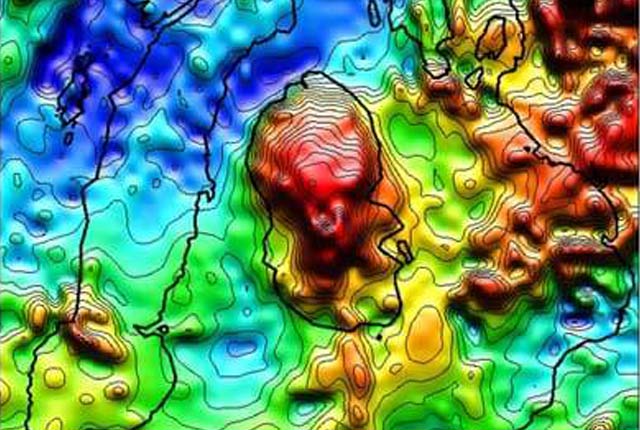
The gridded nature of areas of GeoClimate Premium is due to the resolution of the soil moisture deficit data generated using the BGS groundwater model (ZOODRM). This provides an output grid with a resolution of 2 km2. When combined with the geological 1:50 000-scale polygon dataset, in areas where the soil moisture deficit values lead to a varying GeoClimate Premium classification, across areas of consistent volume change potential, the grid is clearly visible.
In areas where there is currently low or limited clay shrink–swell susceptibility (e.g. GeoSure values of A and B) it is less likely that mitigation work will have taken place. However, if these areas are projected to experience higher susceptibility to clay shrink–swell in the future, the impact in these areas could be higher due to this vulnerability. In comparison, buildings that have been underpinned or built with deeper foundations will have a lower vulnerability and the impact of ground movement will be lessened.
We offer additional services on top on the GeoClimate data product. This could include modified projections based on different climate datasets or scenarios, thresholds or changes to the input variables. Please contact us to discuss your requirements.
Relative topics
You may also be interested in
Digital data licensing and resellers
Providing a wide range of licences for the use and utilisation of our information products by for those interested in an information product and the Open Government Licence is not applicable.

BGS GeoSure
The BGS GeoSure datasets identify areas of potential hazard and, therefore, potential natural ground movement, in Great Britain.