How the geology on our doorstep can help inform offshore infrastructure design
BGS is part of a new collaboration using onshore field work to contextualise offshore data and update baseline geological models which can inform the sustainable use of marine resources.
19/11/2025 By BGS Press

In 2023, BGS entered into a data-sharing partnership with Ossian to enhance understanding of the seabed and shallow subsurface conditions across the United Kingdom continental shelf . The partnership granted BGS access to Ossian’s extensive survey data, with the development set to become one of the world’s largest floating wind farms.
In total the lease area covers 858 km² and is located 84 km off Scotland’s east coast. Once glaciated and now submerged at approximately 72 m depth, the site offers a unique opportunity to investigate offshore stratigraphy and geomorphology in a region undergoing rapid environmental and industrial transformation. It also allows researchers to compare findings to Ossian’s parent company SSE Renewables’ other projects in the Firth of Forth: Berwick Bank and Seagreen.
As part of the project, BGS scientists hosted a dedicated workshop attended by members of the Ossian project team, which included a mini-field trip day in Midlothian close to the BGS office in Edinburgh. The field trip allowed the project teams to explore similarities to geological features found onshore and discuss the broader implications for interpreting offshore survey data. By examining glacial deposits, meltwater channels and till sequences in a terrestrial setting, geoscientists can refine offshore geological models and reduce uncertainty in infrastructure design.
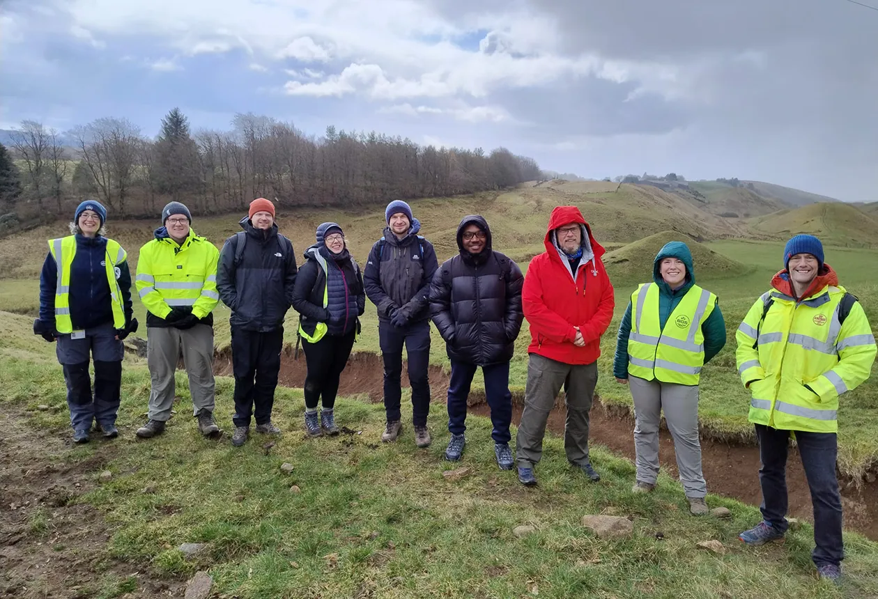
Members of the BGS and Ossian project teams at Carlops during the field trip. The site visit provided an opportunity to discuss glacial geomorphology in the field and explore how onshore analogues can inform offshore interpretations and infrastructure planning. BGS © UKRI.
A key example observed during the field trip was the heterogeneity of the sediments across relatively small areas, with notable variations in grain size, composition and depositional structure. These complexities mirror the variability of ground conditions found offshore and highlight the importance of detailed site characterisation when planning and constructing marine infrastructure.
To help contextualise the offshore data, the field trip explored several key geological sites in Midlothian, each offering valuable insights into glacial processes and sedimentary environments similar to those observed beneath the sea.
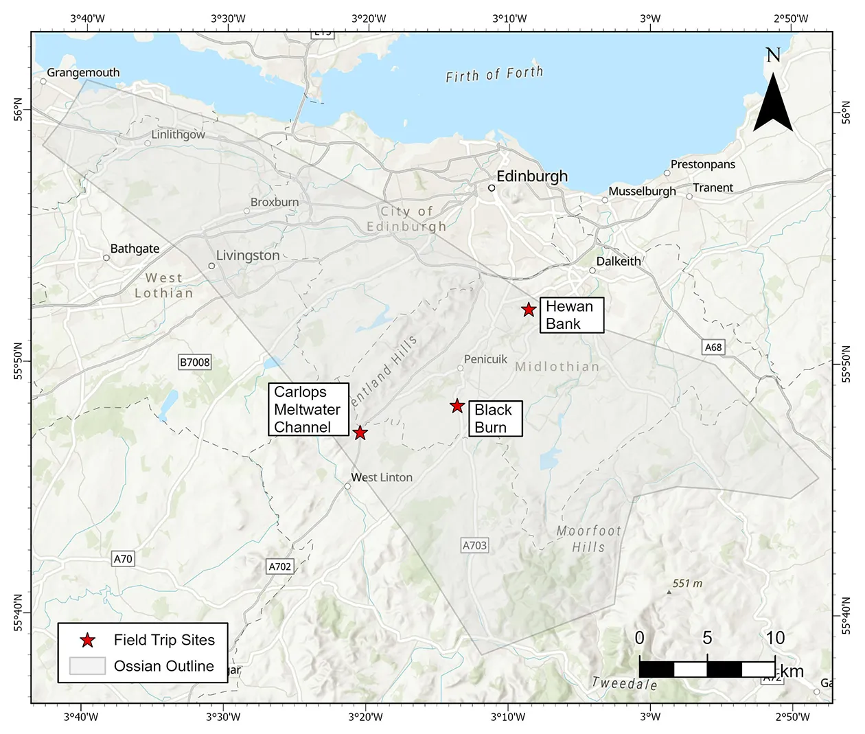
Locations of field trip sites visited during the BGS/Ossian field day in Midlothian. The three sites, Carlops meltwater channel, Black Burn and Hewan Bank, are all featured on the Scottish Geology Trust website. The outline of the Ossian offshore wind farm lease area is overlaid to illustrate the scale of the offshore development relative to the onshore sites. This visual comparison helps contextualise how small-scale geological variability observed onshore can inform interpretations of much larger offshore environments. Base map © OpenStreetMap. BGS © UKRI.
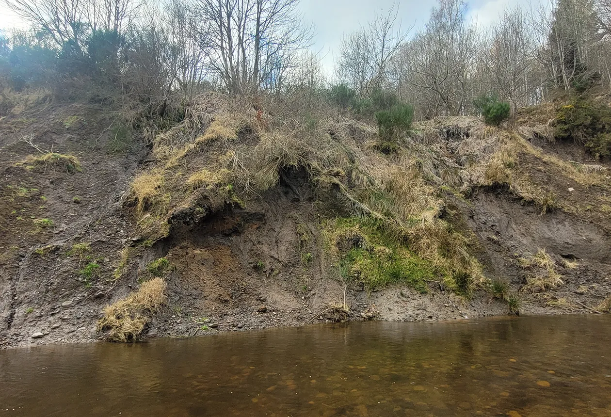
Auchencorth Moss: Black Burn exposure (Local Geodiversity Site)
Auchencorth Moss is an extensive, peat-covered plateau dissected by small streams and drainage channels. The Black Burn site, where a tributary joins the River North Esk near Penicuik, features an exposure of three distinct glacial tills with varying physical characteristics and compositions. Though partially obscured by slope wash and vegetation, the upper sections remain visible and accessible for study. The exposure reveals how glacial processes deposited and reworked sediments, which act as a useful analogue for interpreting stratified units offshore.
Carlops meltwater channel
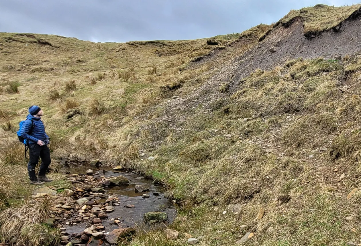
There is a classic example of a subglacial meltwater channel systems at Carlops, a Geological Conservation Review Site and partially a Site of Special Scientific Interest (SSSI).
The bedrock-cut channels at Carlops exhibit braided forms, rock islands and chute features. These geomorphological structures help explain the evolution of meltwater systems beneath ice sheets, which are also evident in offshore channel features. The site also provides a good opportunity to emphasise the scale of channel features, helping to conceptualise the variability of the offshore landscape.
Hewan Bank
Hewan Bank, an SSSI located close to Roslin Glen, presents a textbook sequence of two tills overlain by sands and gravels. The locality has been used to construct the regional glacial stratigraphy for the Edinburgh and Lothians area.
The debate over whether these represent separate glaciations or complex depositional environments mirrors the interpretive challenges faced offshore, where seismic and core data must be carefully analysed to distinguish between similar units. The wider Roslin Glen area, known for its meltwater gorge and incised meanders, also illustrates the erosional power of glacial meltwater and the formation of geomorphological features that can be traced in offshore bathymetry and sediment records.
Collaboration
The collaboration between Ossian, SSE Renewables and BGS provides important new data that is being used to update baseline geological models for the Central North Sea and the Firth of Forth. These feed into BGS’s publicly available offshore maps and datasets, which support a wide range of users including developers, regulators, researchers and marine planners. Integrating data from offshore wind farms such as Ossian with existing geological frameworks will help to guide future offshore developments and promote the sustainable use of marine resources.
This initiative also builds on BGS’s longstanding relationship with Ossian joint venture partner SSE Renewables and highlights the value of sustained collaboration in delivering large-scale renewable energy projects. The Ossian floating wind farm, which is a joint venture between SSE Renewables, Marubeni and Copenhagen Infrastructure Partners (CIP), is set to deliver up to 3.6 GW of renewable energy, enough to power 6 million homes and offset up to 7.5 million tonnes of carbon emissions, marking a significant step forward in the UK’s journey to net zero.
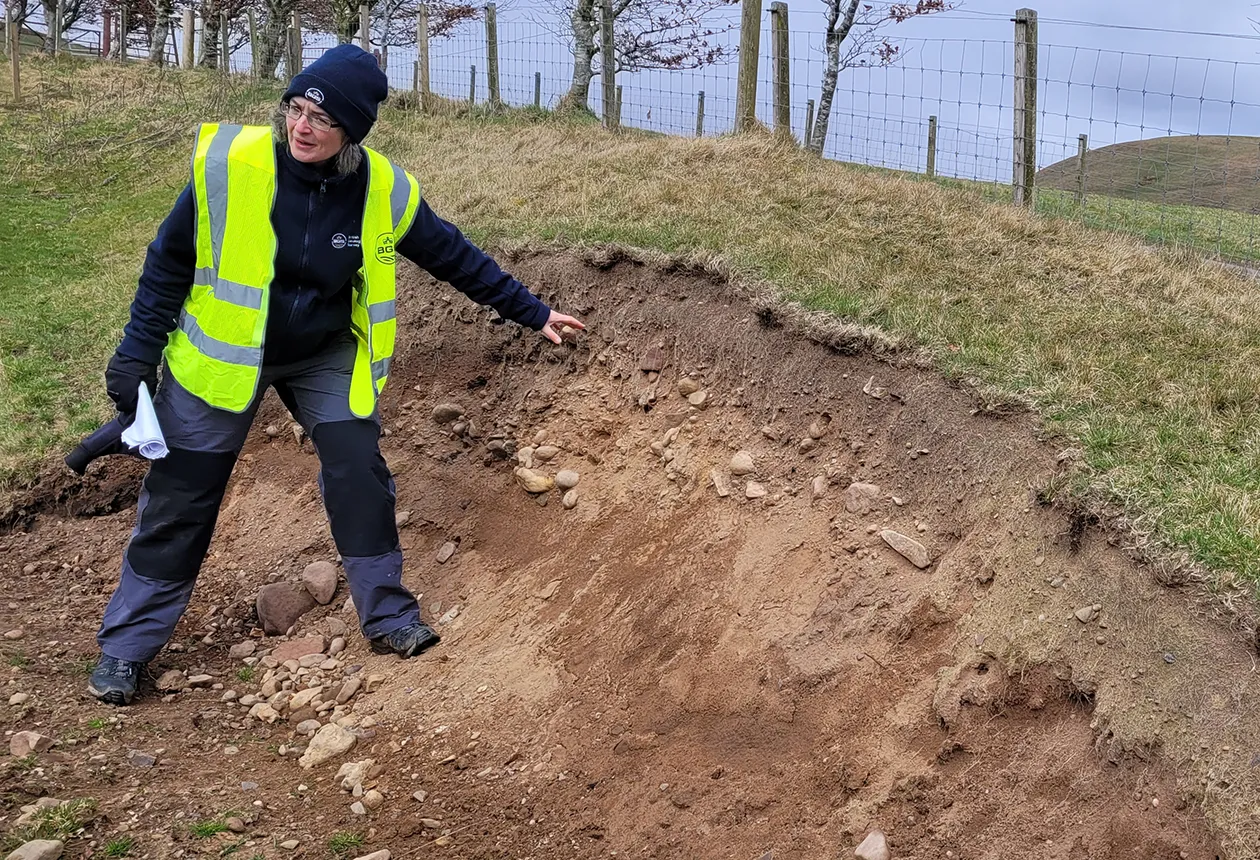
BGS Marine Geoscientist Duncan Stevens observing the glacial till exposure at the Black Burn site, Auchencorth Moss. The site shows multiple stacked till units with varying composition and structure, offering valuable insights into sediment heterogeneity, a key consideration when interpreting offshore stratigraphy and designing marine infrastructure. BGS © UKRI.
BGS Marine Geoscientist Margaret Stewart describes the till and topsoil overlying the bedrock-cut meltwater channels at Carlops, a classic example of a subglacial drainage system. BGS © UKRI.
Hewan Bank, showing the basal till within the exposed glacial succession. Only the basal section is visible in the photograph; however, the wider site provides an example of stratigraphic layering used to interpret glacial history, offering valuable parallels to offshore sediment sequences. BGS © UKRI.
About the author
Related news

Updated national 3D model will determine the depth to the solid bedrock beneath our feet
13/07/2026
The BGS Superficial Deposit Thickness Model now includes an elevation model of geological rockhead for the first time, providing important data for civil engineers, geoscientists and environmental scientists.

Cheshire Geoenergy Observatory releases key geological datasets for UK thermal energy storage scheme design
09/07/2026
A new report and data packs from BGS will provide a unique resource for scientists working on the geology and hydrogeology of the Sherwood Sandstone Formation, an important aquifer and reservoir rock.

Geological research in North Sea helping to safeguard subsea cables
06/07/2026
Subsea power and telecommunications cables are critical to the UK’s energy infrastructure and global connectivity, yet they remain vulnerable to damage from ship anchors, fishing activity and natural hazards.

UK and Philippines scientists investigate natural hydrogen generation processes at atomic scale
22/06/2026
BGS researchers were granted access to use the Diamond Light Source facility in order to study hydrogen in light brighter than the sun.

Shortage of end-of-life materials presents challenge to UK critical minerals security
17/06/2026
A new report by the UK Critical Minerals Intelligence Centre reveals insufficient end-of-life material stocks present a supply risk over the coming decade, but offer significant long-term potential to meet critical mineral demand through recycling.

UK geothermal catalogue receives update
16/06/2026
BGS releases the second digital version of the UK geothermal catalogue of subsurface temperature and rock thermal conductivity measurements and heat flow calculations.
Natural hydrogen research
Understanding aspects of the natural hydrogen value chain on a national and international level.

Strengthening capacity through partnership: a critical minerals perspective
28/04/2026
BGS has been working in partnership with the Geological Survey Department of Zambia (GSD) to build national capacity, improve data accessibility and support long-term, sustainable development.

UK scientists unite for seabed mapping survey of the UK’s south-west coastline
15/04/2026
BGS geologists join research voyage, gathering crucial geological data to support offshore energy and infrastructure projects.

Isotopes and science: my student placement at BGS
08/04/2026
Industrial placements at BGS for undergraduate students give real-life experience of working in laboratories and learning different analytical techniques.

Updated geological assessment of the Southern North Sea set to underpin future offshore infrastructure development
25/03/2026
The first regional assessment for 30 years will support offshore marine and subsurface planning for the UK’s low-carbon energy infrastructure, including the 2030 target of 45 to 50 GW generated through offshore wind.

UK Critical Minerals Intelligence Centre 2026 showcase
Event on 31/03/2026
A special live webinar with the team from the Critical Minerals Intelligence Centre showcasing the latest research from 2026 on copper, the future of digital, and what’s next for the criticality assessment. A recording of the event is now available.