World Cities Day: the geological story of our cities
Understanding the rocks that underlie our towns and cities, the risks they can present and how they influence urban planning and redevelopment.
31/10/2025 By BGS Press

Every city has a story hidden beneath its surface, shaped not just by people but by ancient landscapes and geological forces too. Under our streets, buildings and parks lies an unseen subsurface that has a major influence on how our cities function, grow and adapt.
On World Cities Day, we are highlighting urban geoscience — the study of the ground beneath our towns and cities — and why understanding this hidden world is essential for building safer and more resilient urban environments.
What is urban geoscience?
Urban geoscience helps us to understand the geology and both the natural (for example, ancient river valleys and glacial deposits) and human-made features (for example, old mine workings) beneath our cities. This knowledge helps planners and decision makers to more safely utilise the subsurface — for example, for water, energy and transport tunnels — while avoiding any challenges caused by the complex and sometimes unpredictable geology beneath our feet. As cities develop, urban geoscience offers the insight needed to mitigate risk and plan with confidence.
Examples of how British cities are influenced by geology
There are countless ways in which geology influences the evolution of our towns and cities. Here are four examples from around Britain.
London: shrink–swell clay and the changing climate
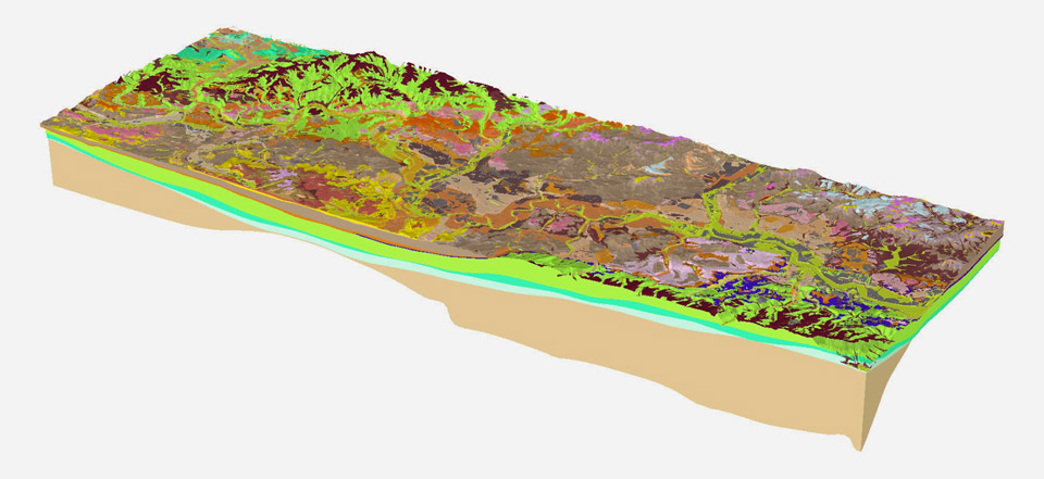
3D geological model of London. BGS © UKRI.
Much of London is built on the London Clay Formation. This unit has clay-rich deposits that expand when wet and shrinks when dry, a phenomenon known as shrink–swell. This movement can cause cracks in buildings, damage roads and disrupt underground utilities.
With climate change, hotter and drier summers followed by intense rainfall are worsening the effects of shrink–swell. The BGS GeoClimate dataset models how these risks may change over time, showing areas most likely to experience future subsidence. Such modelling can allow for preventative or mitigative steps to be put in place to alleviate the effects of the hazard on property and infrastructure.
Glasgow: mining and geothermal energy
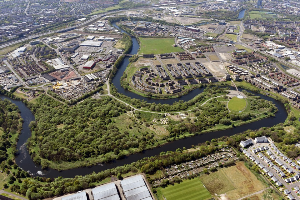
Cuningar Loop in Glasgow is home to one of the UK Geoenergy Observatories, investigating the potential to use heat stored in flooded, abandoned mines as a sustainable energy source. Photo by Clyde Gateway.
Glasgow sits on the Carboniferous-aged Limestone Coal Formation and the coal mined from beneath the city powered its industrial growth. The old mine workings have left voids in the subsurface that can collapse and, if the collapse is close to the surface, cause subsidence. However, if potential issues are known, preventative measures can be put in place to reduce the risk.
The BGS Mining Hazard dataset helps identify areas where past underground mining might pose a risk, supporting safer planning and development. Old mine workings are also providing new opportunities as warm water in flooded mine workings can be used to supply low-carbon heat and hot water to offices and homes, turning a legacy of coal mining into a resource for clean energy.
Truro: radon risk from granite

Aerial view of Truro in Cornwall, England. © Alexey_Fedoren / iStockPhoto.com
Truro in Cornwall is a city built on Carboniferous to Permian-aged granite intrusions, which were formed when molten rock slowly cooled deep underground. Granite contains small amounts of the radioactive element uranium, which naturally breaks down (via a series of intermediate, unstable elements) over millions of years to produce radioactive radon gas.
In enclosed spaces like homes and offices, radon may build up to levels that pose a health risk, with prolonged exposure to elevated levels of radon increasing the risk of lung cancer. For most people, the risk of developing lung cancer from exposure to radon remains low. However, the UK Health Security Agency advises you to test your home if you live or work in a radon affected area and there are several methods of reducing high radon levels in buildings.
Cornwall is just one of several areas around the UK were radon gas needs to be considered. The BGS/UKHSA Radon Potential dataset shows where elevated radon levels are most likely, showing where testing and mitigation are needed around the UK to make homes safer.
Cardiff: complex ground and urban redevelopment
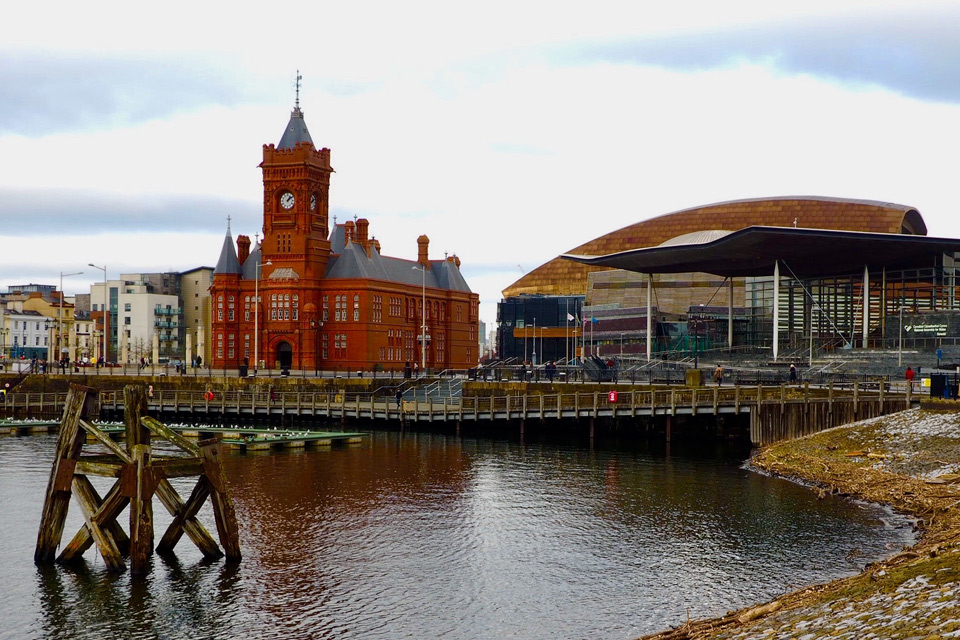
View of Cardiff Bay with the Pierhead Building and the Senedd. BGS © UKRI.
The combination of river sands and gravels, glacial deposits and rocks of the Triassic-aged Mercia Mudstone Group beneath the city of Cardiff affect drainage, groundwater flow and how easily the ground can be built on. As the city continues to grow and redevelop, understanding the subsurface is key for managing groundwater, avoiding subsidence and planning safe infrastructure.
The BGS 3D urban geology model for Cardiff helps to visualise the deposits beneath the city, while the BGS Civils dataset provides practical information on ground stability, excavation difficulty and chemical risks to construction materials.
Every city around the world is shaped or influenced to some degree by the rocks that lie beneath its foundations, a changing coastline along its shore or the risks posed by geohazards such as earthquakes, landslides or radon. As cities continue to grow and face new challenges, from a need to become climate resilient to an increasingly crowded subsurface, understanding the ground beneath them becomes more important than ever.
Urban geoscience connects the past with the present, helping us build cities that are not only functional but also resilient.
Relative topics
Related news

Isotopes and science: my student placement at BGS
08/04/2026
Industrial placements at BGS for undergraduate students give real-life experience of working in laboratories and learning different analytical techniques.

Updated geological assessment of the Southern North Sea set to underpin future offshore infrastructure development
25/03/2026
The first regional assessment for 30 years will support offshore marine and subsurface planning for the UK’s low-carbon energy infrastructure, including the 2030 target of 45 to 50 GW generated through offshore wind.

New research could help provide a more reliable water supply for millions in rural Africa
24/03/2026
A new BGS-led study has revealed crucial insights into the longstanding challenges affecting the reliability and performance of rural water supply infrastructure in sub-Saharan Africa.

Call for new members and Chair to join the NERC facilities steering committees
25/02/2026
New members are needed to join the committees over the next four years.

Your views wanted: developing a geothermal energy subsurface data portfolio
24/02/2026
BGS is aiming to support the growth of the sector by providing the best-available, location-specific geothermal and ground source heat information as an accessible product or service.

Map of BGS BritPits showing the distribution of worked mineral commodities across the country
18/02/2026
BGS’s data scientists have generated a summary map of the most commonly extracted mineral commodities by local authority area, demonstrating the diverse nature of British mineral resources.

Funding awarded to map the stocks and flows of technology metals in everyday electronic devices
12/02/2026
A new BGS project has been awarded Circular Electricals funding from Material Focus to investigate the use of technology metals in everyday electrical items.

New UK/Chile partnership prioritises sustainable practices around critical raw materials
09/02/2026
BGS and Chile’s Servicio Nacional de Geología y Minería have signed a bilateral scientific partnership to support research into critical raw materials and sustainable practices.

Extensive freshened water confirmed beneath the ocean floor off the coast of New England for the first time
09/02/2026
BGS is part of the international team that has discovered the first detailed evidence of long-suspected, hidden, freshwater aquifers.

Funding secured to help mitigate ground risk in UK construction sector
05/02/2026
The BGS Common Ground project has been awarded new funding to help unlock the value of ground investigation data.

Can sandstones under the North Sea unlock the UK’s carbon storage potential?
02/02/2026
For the UK to reach its ambitious target of storing 170 million tonnes of carbon dioxide per year by 2050, it will need to look beyond the current well-studied geographical areas.

Quaternary UK offshore data digitised for the first time
21/01/2026
The offshore wind industry will be boosted by the digitisation of a dataset showing the Quaternary geology at the seabed and the UK’s shallow subsurface.