We have developed a series of 3D geology models and urban study reports to support planning and development within major cities of the UK. Underpinned by BGS geological data and expertise, the models and reports provide an enhanced understanding of the geological structures and sediments for urban practitioners to inform construction projects, infrastructure design, groundwater assessments and land use planning.

Gateshead 3D Geological Model BGS © UKRI.
The 3D geology models for London, Glasgow, Cardiff and Liverpool can be accessed without charge on our Onshore GeoIndex viewer. Through the GeoIndex platform users can create geological cross-sections, synthetic boreholes and horizontal slices through the 3D models.
> Go to the GeoIndex viewer (includes the Gateshead 3D geolocial model)
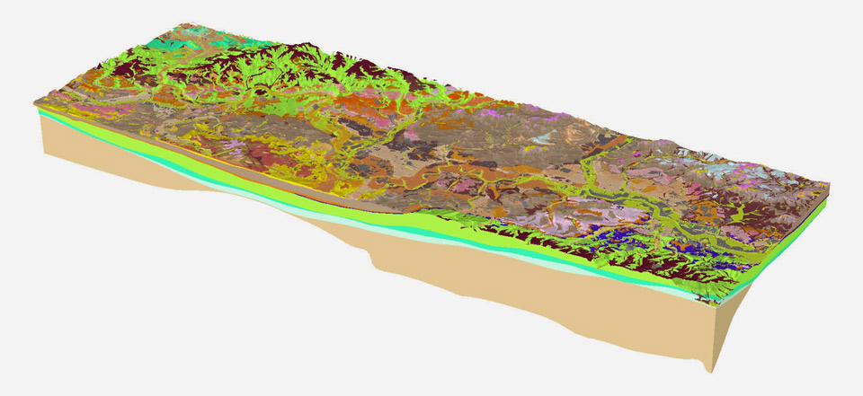
A 3D view of the London Model. Source: BGS © UKRI
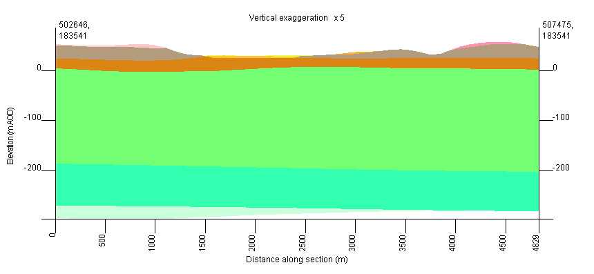
A virtual geological cross-section from the London 3D Geology Model. Source: BGS © UKRI
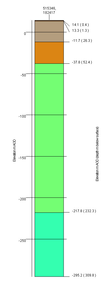
A virtual borehole section from the London 3D Geology Model. Source: BGS © UKRI
Urban study reports
Alongside our 3D geology models, we have published a series of open reports that provide detailed information about 3D model development (metadata reports), as well as information about the geology, hydrogeology, geochemistry and engineering geology of major cities and towns in the UK, to assist urban planners and developers.
| 3D model: | 3D model report |
| Geology: | Geology of London – Memoir |
| Hydrogeology: | Hydraulic conductivity of the Quaternary deposits |
| Geochemistry: | London Earth Soil Geochemistry Viewer |
| Further resources: | Modelling volume change potential in the London Clay |
| 3D model: | 3D model report |
| Geology: | Quaternary geology of the Clyde Valley |
| Hydrogeology: | Quaternary groundwater system |
| Geochemistry: | Soil pollutant impacts on shallow groundwater |
| Further resources: | Lithology of glacial and fluvial deposits in Glasgow |
| 3D model: | 3D model report |
| Geology: | Superficial deposits in Cardiff |
| Hydrogeology: | Urban groundwater temperatures
Groundwater heat pump feasibility |
| Geochemistry: | Baseline geochemistry data |
The Manchester model is currently being updated and is not yet available in the GeoIndex Tool. Please contact our data licensing service (digitaldata@bgs.ac.uk) for more information about accessing model data.
| 3D model: | 3D model report |
| Geology: | Geology of the Manchester district |
| Hydrogeology: | Hydrogeological pathways |
| Further resources: | Engineering geology of the Mercia Mudstone |
| 3D model: | 3D model report |
| Geology: | Geology of Liverpool and District |
| Hydrogeology: | Interpreting borehole water chemistry of the Permo-Trias in Liverpool |
| Geochemistry: | Desk study to identify ground contamination in Warrington, UK |
| Further resources: | Sustainable use of underground space: case studies from UK
Interpretation, description, and representation of anthropogenic deposits |
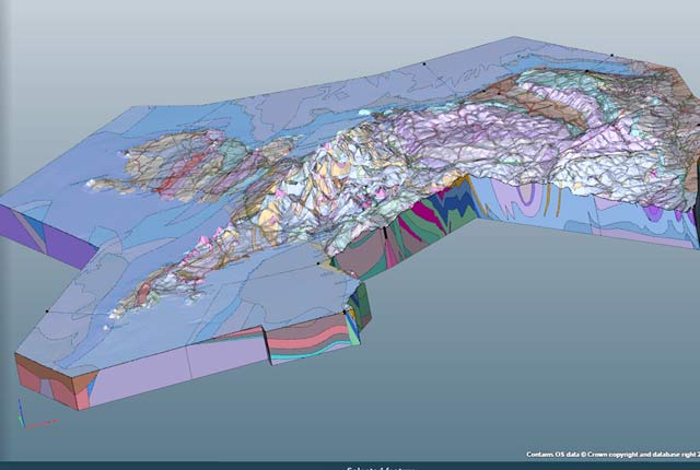
Project Groundwater Northumbria (led by Gateshead Council) is part of the Environment Agency Flood and Coastal Resilience Innovation Programme. As a partner on this project, the BGS have constructed a hydrodomains map of the superficial deposits and a 3D geological model of the bedrock in the Gateshead area to help better understand the subsurface factors that will affect the direction of groundwater flow to help manage and mitigate against groundwater flooding. The BGS reports from this project are openly available through the NERC Open Research Archive (see below), and the sketchfab scene embedded highlights some of the geological considerations for groundwater flow.
Blackburn, J, MacAllister, D J, and Terrington, R. 2026. Hydrogeological conceptual model of the Gateshead Area – Project Groundwater Northumbria. Nottingham, UK, British Geological Survey, 42pp. (Project Groundwater Northumbria series, CR/26/045N)
Kearsey, T, Callaghan, E, Arkley, S, and Reeves, T. 2025. Bedrock Sandstone channel subsurface mapping for the Gateshead area – Project Groundwater Northumbria. Nottingham, UK, British Geological Survey, 29pp. (Project Groundwater Northumbria series, CR/24/080N)
Kearsey, T, Arkley, S, Callaghan, E, Murphy, B, Reeves, T, and Terrington, R. 2025. 3D geological model report of the bedrock geology underlying the Gateshead area – Project Groundwater Northumbria. Nottingham, UK, British Geological Survey, 44pp. (Project Groundwater Northumbria series, CR/24/123N)
Whitbread, K, Dewald, N, Banks, V, Murphy, B, and Reeves, T. 2024. Superficial hydrogeological domains for the Gateshead area – Project Groundwater Northumbria. Nottingham, UK, British Geological Survey, 46pp. (Project Groundwater Northumbria series, CR/24/066N)
Kearsey, T, Whitbread, K, and Callaghan, E. 2023. Project Groundwater Northumbria (FCRIP) – phase 1 geological cross-sections. Nottingham, UK, British Geological Survey, 30pp. (Project Groundwater Northumbria series, CR/22/136N)
Spittal (Berwick Upon Tweed)
Blackburn, J, MacAllister, D J, Terrington, R.. 2026 Hydrogeological conceptual model of the Spittal area – Project Groundwater Northumbria. Nottingham, UK, British Geological Survey, 41pp. (Project Groundwater Northumbria series, CR/26/048N)
Burke, H, Terrington, R, Reeves, T, Murphy, B, Dewald, N, and Banks, V. 2024. Superficial hydrogeological domains for the Spittal area – Project Groundwater Northumbria. Nottingham, UK, British Geological Survey, 44pp. (Project Groundwater Northumbria series, CR/24/064N)
Further urban study reports can be downloaded from GeoIndex viewer (Engineering Geology data layers) and are available for:
|
|
Engineering geology maps of the UK and engineering geology formation reports are also available through the map viewer. For further information about the availability of 3D urban models and urban study reports please contact our enquiries team.
You may also be interested in

Urban geoscience
Providing solutions for urban land-use planning and sustainable development.
Regional geological visualisation models
Interactive 3D models are available for exploring the geology of regional areas of England, Wales and Northern Ireland.
Engineering and Geotechnical Capability
Leading the development and application of field and laboratory infrastructure and long-term management of geophysical and geotechnical property data.