Using satellite imagery for emergency disaster response
BGS has a long history of assisting relief efforts by providing satellite maps, data and interpretation to those affected by disasters, helping to identify hazardous areas to avoid.
06/07/2021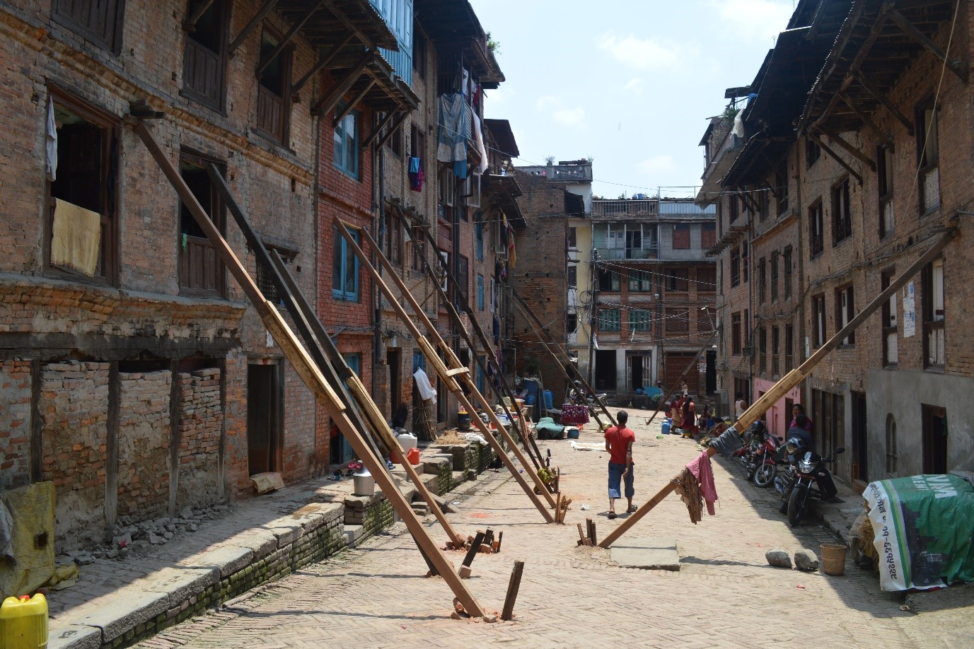

Over the past 35 years, there has been almost a fivefold increase in the number of recorded disaster events, which include geohazards such as landslides, earthquakes, tsunamis and volcanic activity. In the immediate aftermath of these disasters, the timely use of satellite imagery can help to substantially reduce further humanitarian impact and loss of life.
Since 2008, BGS has responded to international calls for satellite-based, disaster situation maps to aid relief efforts and, later, to help build resilience to future events. Working remotely, we rapidly create maps and deliver advice required by a range of stakeholders including governments, international non-governmental organisations (NGOs) and local relief teams working on the ground. In some cases, remote working is also followed by targeted fieldwork.

‘There is no such thing as a natural disaster. Disasters result when a hazard affects human settlement which is not appropriately resourced or organized to withstand the impact and whose population is vulnerable because of poverty, exclusion or socially disadvantaged in some way.’
Mizutori, United Nations Office for Disaster Risk Reduction, 2020.
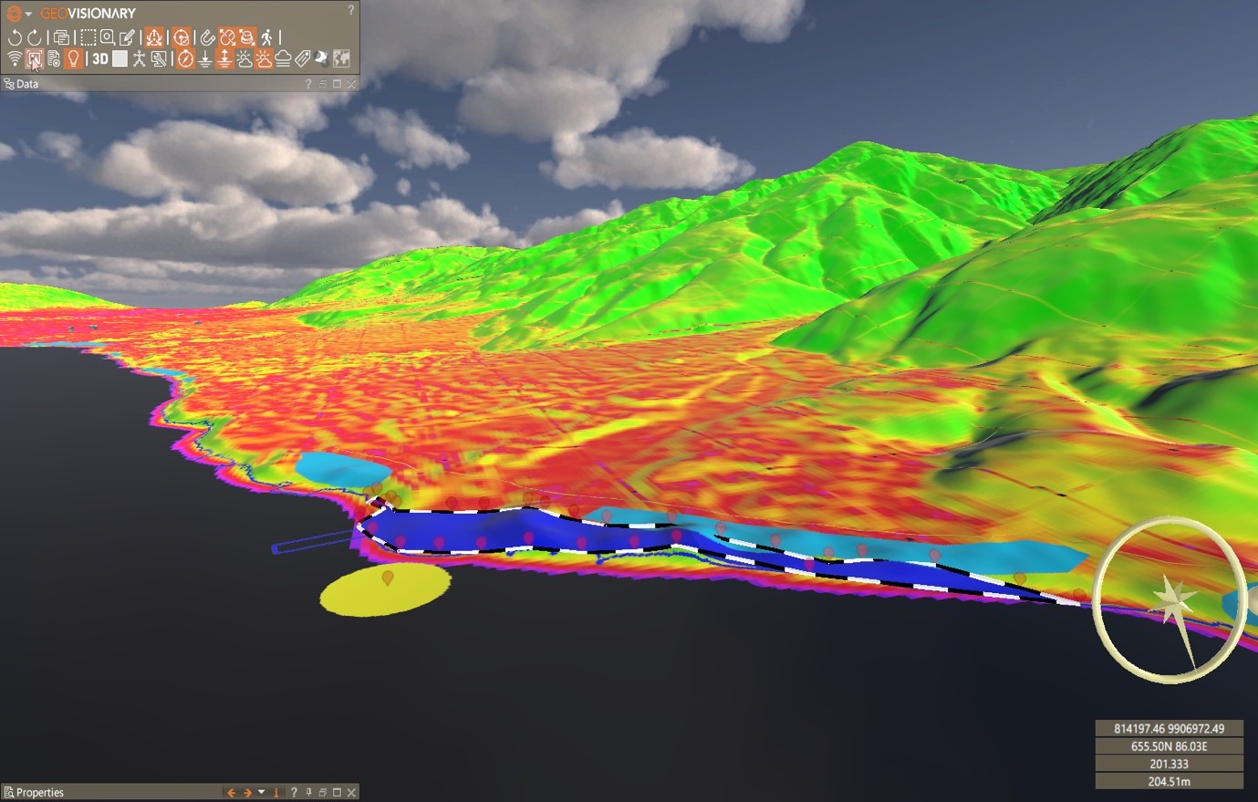
BGS routinely gathers and pre-prepares global imagery and elevation datasets. When a disaster occurs, we have base data ready and can quickly integrate new imagery and data to respond to disasters using custom 3D geological interpretation environments. BGS © UKRI.
Emergency response
Satellite imagery has wide applicability for the full disaster lifecycle, including response. Satellites capture consistent data of differing spatial and spectral resolutions over large areas (up to thousands of square kilometres) with no risk to human life. These characteristics, along with the complementary nature of optical and radar data, improve what can be monitored over difficult terrain at times when access is made impossible by the disaster.
In many cases, satellite imagery is the only timely source of data for emergency response. Recognising these benefits, many satellite imagery providers are making their imagery freely available for disaster response through a variety of mechanisms, e.g. the UN International Charter: Space and Major Disasters.
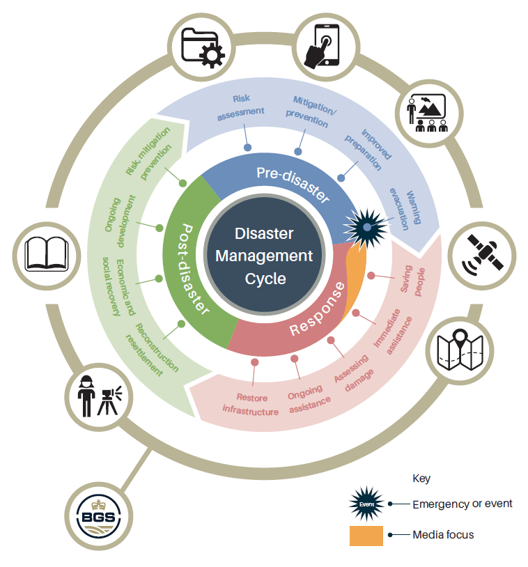
The full disaster management cycle is shown by the inner two circles. The outer (gold) circle shows the BGS activities that support immediate relief efforts (response). This includes satellite map production and interpretation, which may be followed by fieldwork and published reports (post-disaster). The last step of the cycle may include the delivery of data products and training in preparation for future events (pre-disaster). BGS © UKRI; adapted from The International Charter Space and Major Disaster/ESA GSE RESPOND.
BGS emergency response timeline
2008 — Montserrat: volcanic eruption
he International Charter: Space and Major Disasters was activated to acquire satellite observation data covering the eruption event of the Soufrière Hills volcano on the Caribbean island of Montserrat on 29 July 2008. Earth observation data, provided rapidly by BGS and the University of Reading, was a crucial piece of evidence used by scientists in advising government on the post-eruption state of the volcano. As a result, people who had been evacuated following the eruption were able to return to their homes.
2011 — Japan: earthquake and tsunami
On 11 March 2011, a M9.0 earthquake caused a devastating tsunami along a 500 km length of the eastern shoreline of Honshu Island, Japan. The earthquake itself caused relatively little damage, but the resulting tsunami caused a great loss of life and damage. BGS used satellite imagery to quickly determine where the tsunami had inundated and to help decipher its flow paths and assess the damage caused. Soon afterwards, BGS staff joined an international team studying sediments laid down by the tsunami. The research led to a better understanding of the impact of future tsunamis and how they will affect lives and livelihoods. This work also improved international collaboration on this key topic.
2015 — Pakistan: earthquake and landslides
On 26 October 2015, a M7.5 earthquake struck north-west Pakistan. The earthquake caused damage to more than 100 000 houses, which led to a significant loss of life. Landslides blocked roads, which further hindered relief efforts. BGS provided a limited response for the FCDO, DfID and Civil Contingencies Secretariat, which included a briefing document on ‘Any information on landslide and risk of future landslides’.
2015 — Nepal: earthquake and landslides
The 2015 earthquake sequence in Nepal, including the M7.8 Gorkha earthquake of 25 April and the M7.3 Dolakha aftershock of 12 May, triggered several thousand landslides. BGS led the UK response to an urgent UK Government request to provide advice on landslide hazard and impacts. Imagery from the International Charter: Space and Major Disaster (and from other suppliers) was used to deliver ) to UK Government, to help coordinate and inform our response on the ground, and to relief organisations (e.g. World Food Programme; MapAction; UNOSAT) to help plan and deliver aid. Subsequently, BGS also led the UK Government-funded project to monitor landslide activity throughout the following six months when the monsoon hit Nepal.
‘In the name of ESA congratulations… BGS is really tackling an important piece of work in the context of DRM [disaster risk management] in Nepal.’
‘Thank you, and all your team for all the fantastic work you are doing on producing imagery following the two earthquakes in Nepal and for future monsoon work [….] and as always BGS give excellent products, which I have put in front of ministers at every opportunity.’
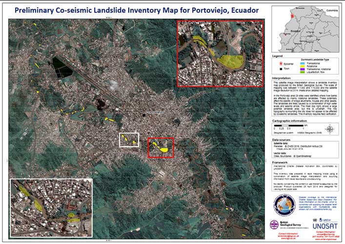
2016 — Ecuador: earthquake
BGS played a leading role in building an inventory of landslides and advising on the associated hazards following the M7.8 Ecuador earthquake on 16 April 2016. Landslide situation analyses were produced for a number of areas in Ecuador, providing valuable advice to the UK Government and international agencies. A variety of satellite imagery (obtained via the International Charter: Space and Major Disasters) was used to create maps of landslides active since the earthquake.
‘558 landslides were detected by our partners from the British Geological Survey using data provided by UNOSAT. This information is made available for the recovery efforts to rebuild after the earthquake, thus helping to bridge the data gap from emergency situation to reconstruction.’
BGS was included in the group that won the USGS-NASA Pecora Award in 2017 for ‘outstanding support to the global community during times of crisis’. The award recognised the project management and mapping products provided by BGS as part of several responses worldwide.
2017 — Sierra Leone: landslides
On 14 August 2017, heavy rain fell in the Sierra Leone capital, Freetown, which triggered a catastrophic landslide that travelled 6 km through the city to the sea. A national emergency was declared; more than 3000 were left homeless, hundreds of buildings were buried or completely destroyed and over 1000 fatalities were recorded. The International Charter (264) was activated on behalf of the Food and Agricultural Organisation (FAO) Sierra Leone Office and BGS immediately provided maps and advice. The recently elected President approved a new Mudslide Prevention Inter Agency Committee to tackle the issue of landslides and urban development.
‘The [2018] Sierra Leone Multi-City Hazard Review and Risk Assessment would not have been possible without the dedication and support of different partners and stakeholders at national and local levels, who contributed both time and expertise.’
Ove Arup & Partners International Ltd (report authors) on behalf of The World Bank.
2018 — Philippines: typhoon and landslides
Following the activation of Charter 586, Typhoon Mangkhut in Philippines, in September 2018, BGS scientists produced a landslide inventory, which mapped 263 landslides. The inventory was prepared in rapid mapping mode based on satellite interpretation, which focused on areas near roads, buildings and rivers.
2018 — Indonesia: earthquake, tsunami and landslides
A large M7.5 earthquake in Palu, Sulawesi, Indonesia, on 28 September 2018, triggered liquefaction flows and coastal landslides leading to tsunami. The BGS study assessed ‘before and after’ high-resolution optical imagery to establish inundation limits and coastline changes. Fieldwork was then undertaken to assess coastal landslides as sources of the tsunami.
This work was funded through a NERC urgency grant. BGS worked with the Indonesian Agency for the Assessment and Application of Technology (BPPT), who assisted with data collection, fieldwork and logistics. The impacts of this work included a strengthening of research partnerships, increased understanding of tsunami mechanisms and, therefore, better-informed tsunami generation models.
2018 — Anak Krakatau: tsunami
The volcano Anak Krakatau (‘Child of Krakatoa’), located between Java and Sumatra, collapsed on 22 December 2018, causing a devastating tsunami that killed hundreds of people and displaced tens of thousands more living on the coasts of Indonesia.
BGS earth observation staff used satellite data to assist the fieldwork, which required the collection of laboratory samples and to understand the interactions between eruptive activity and sector collapse at Anak Krakatau. Satellite data was the only consistent source of data between June and December 2018. This data provided evidence of relatively low-intensity Strombolian activity, which prevented any fieldwork on the ground. This low-intensity activity was a precursor to the final collapse, which halved the original size of the island.
The work was funded by Global Geological Risk Platform of the BGS NC-ODA grant NE/R000069/1: Geoscience for Sustainable Futures and two NERC grants: NE/S003509/1 and NE/T002018/1
2019 — Mozambique and Zimbabwe: Cyclone Idai
Tropical Cyclone Idai made landfall on 14 March 2019 through Beira City, central Mozambique. Heavy rains, flash flooding and landslides caused extensive damage to key road routes and bridges before cutting off many affected areas. BGS was approached by the FCDO (DfID at the time), which was leading the UK humanitarian response to the event. We supplied UK Government with a rainfall-triggered landslide hazard classification based on satellite data. Our results were passed to the EU Emergency Response Coordination Centre (ERCC) for use by civil protection teams.
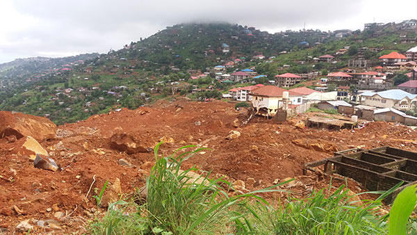
Debris from the Freetown landslide, including huge boulders. Freetown, Sierra Leone, 15 August 2017. BGS © UKRI.
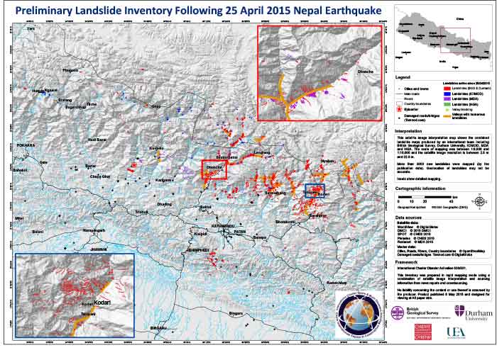
Map of over 3000 active landslides in Nepal, produced by BGS and Durham University and other agencies. Published 8 May 2015. BGS © UKRI.
Practice change
In the immediate aftermath of geohazard events, rapid response is necessary, so preparing and establishing workflows, processes and output templates is crucial. For example, prior to events, preparation of susceptibility maps facilitates pre-positioning for potential future events. After events, mobile data-capture systems are used in the field to quickly and accurately record information on the ground.
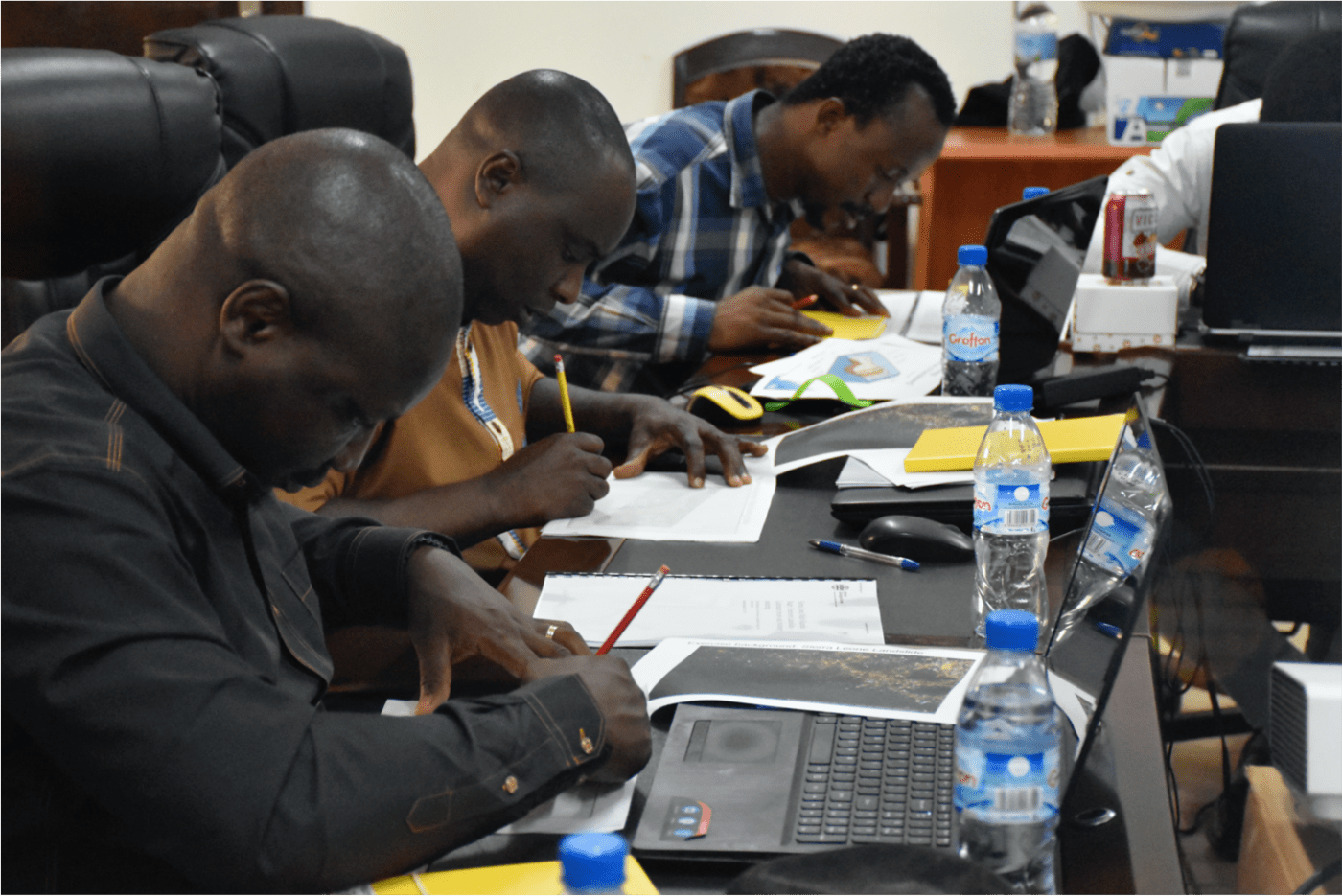
National Minerals Agency staff working through a BGS-led training exercise in hazard mapping, Sierra Leone. BGS © UKRI.
The BGS-led METEOR project takes a step-change in the application of earth observation. This project not only looks at exposure to hazards; it also addresses multi-hazards and their impacts on lives and livelihoods. The project has released exposure data that we developed for 44 countries, which will help our international disaster planning and responses for events in the future. We are specifically working with two countries, Nepal and Tanzania, to provide robust data at national scale for disaster risk management (DRM). However, the direct impacts on lives and livelihoods are difficult to quantify and/or evidence due to the dynamic way disaster events unfold.
Sustainable development goals
![E-WEB-Goal-01[1]](https://www.bgs.ac.uk/wp-content/uploads/2021/01/E-WEB-Goal-011-960x960.png)
Target 1.5 of SDG 1: by 2030, build the resilience of the poor and those in vulnerable situations and reduce their exposure and vulnerability to climate-related extreme events and other economic, social and environmental shocks and disasters.
The BGS ODA Programme is addressing this by working with partners from the Caribbean to Nepal to develop tools (such as smartphone apps) and improve our knowledge of hazard processes (e.g. landslides) and their impacts on lives and livelihoods
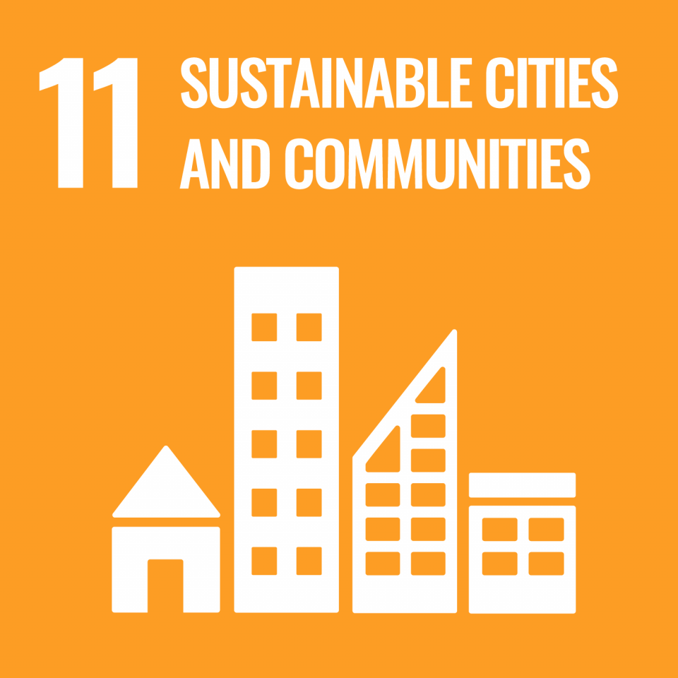
Target 11.5 of SDG 11: by 2030, significantly reduce the number of deaths and the number of people affected and substantially decrease the direct economic losses relative to global gross domestic product caused by disasters, including water-related disasters, with a focus on protecting the poor and people in vulnerable situations.
The METEOR project supports this aim by providing robust exposure data for all 47 least developed countries on the OECD list to help make informed Disaster Risk Management decisions.
Target 17.16 of SDG 17: enhance the global partnership for sustainable development, complemented by multi-stakeholder partnerships that mobilise and share knowledge, expertise, technology and financial resources, to support the achievement of the sustainable development goals in all countries, in particular developing countries.
The METEOR project is committed to working with a range of partners within the project framework and with local governments and relief agencies to facilitate resource mobilization, technology and capacity-building.
Partners and funding
Our disaster response efforts are supported by funding streams such as NERC Urgency Grants, the Global Geological Risk Platform of the British Geological Survey NC-ODA grant NE/R000069/1: Geoscience for Sustainable Futures, and BGS National Capability funds.
Further information
Find out more about BGS disaster response research or contact BGS Enquiries.
About the author

Luke Bateson
Acting head of shallow geohazards and Earth observation; head of geodesy and remote sensing (Keyworth)
Relative topics
References
Bateson, L, Tappin, D R, Novellino, A, Udrekh, Frederik, M, and Putra, P S. 2020. Report on NERC Urgency Grant NE/S015930/1 — September 28th 2018 Sulawesi Tsunami — BGS disaster response. British Geological Survey Internal Report.
British Geological Survey. 2008. Charter final operation report Charter ID 213: volcanic eruption of 29th July 2008 on the island of Montserrat. (Keyworth, Nottingham: British Geological Survey.)
Grilli, S T, Tappin, D R, Carey, S, Watt, S F, Ward, S N, Grilli, A R, Engwell, S L, Zhang, C, Kirby, J T, Schambach, L, and Muin, M, 2019. Modelling of the tsunami from the December 22, 2018 lateral collapse of Anak Krakatau volcano in the Sunda Straits, Indonesia. Scientific Reports, Vol. 9(1), 1–13. DOI: https://doi.org/10.1038/s41598-019-48327-6
International Charter: Space and Major Disasters. 2015. [Online] Charter activations: earthquake and landslide in Nepal and India. [Cited 1 February 2021]. Available at https://disasterscharter.org/web/guest/activations/-/article/landslide-in-nep-2
International Charter: Space and Major Disasters. 2016. [Online] Earthquake in Ecuador. [Cited 1 February 2021]. Available at https://disasterscharter.org/web/guest/activations/-/article/earthquake-in-ecuador
International Charter: Space and Major Disasters. 2018. [Online] Earthquake and tsunami in Indonesia. [Cited 2 February 2021]. Available at https://disasterscharter.org/web/guest/activations/-/article/earthquake-in-indonesia-activation-587–
International Charter: Space and Major Disasters. 2018. [Online] Typhoon Mangkhut in Philippines. [Cited 2 February 2021]. Available at https://disasterscharter.org/web/guest/activations/-/article/cyclone-in-philippines-activation-586–
International Federation of Red Cross and Red Crescent Societies. 2020. World Disasters Report. (Geneva). Available from https://redcross.eu/uploads/files/Latest%20News/World%20Disasters%20Report%202020/World%20Disasters%20Report%202020.pdf.
III.ORG. World Weather-Related Natural Catastrophes by Peril, 1980–2018. [Graphs]. Insurance Information Institute (Source Munich Re). [Cited 29 November 2020]. Available at https://www.iii.org/fact-statistic/facts-statistics-global-catastrophes
Novellino, A, Engwell, S L, Grebby, S, Day, S, Cassidy, M, Madden-Nadeau, A, Watt, S, Pyle, D, Abdurrachman, M, Edo Marshal Nurshal, M, Tappin, D R, Kurniawan, I A, and Hunt, J. 2020. Mapping recent shoreline changes spanning the lateral collapse of Anak Krakatau Volcano, Indonesia. Applied Sciences, Vol. 10(2), 536. DOI: https://doi.org/10.3390/app10020536
Novellino, A, Jordan, C, Ager, G, Bateson, L, Fleming, C, and Confuorto, P. 2019. Remote sensing for natural or man-made disasters and environmental changes. 23–31 in Geological Disaster Monitoring Based on Sensor Networks. Durrani, T, Wang, W, and Forbes S (editors). (Singapore: Springer.) DOI: https://doi.org/10.1007/978-*******0992-2_3
Sierra Leone Telegraph. 2017. Sierra Leone government to provide financial package for mudslide victims. Sierra Leone: Sierra Leone Telegraph. [Cited 1 February 2021]. Available at https://www.thesierraleonetelegraph.com/sierra-leone-government-to-provide-financial-package-for-mudslide-victims/
Tappin, D R. 2018. The importance of geologists and geology in tsunami science and tsunami hazard. Geological Society, London, Special Publications, Vol. 456, 5–38. DOI: http://dx.doi.org/10.1144/SP456.11
The World Bank. 2018. Sierra Leone Multi-City Hazard Review and Risk Assessment; Final Report (Volume 1 of 5). Available from http://documents1.worldbank.org/curated/en/821161549318730387/pdf/130797-v1-FInal-Report-Volume-1-of-5-Technical-Methodology-and-SoR.pdf.