New seabed geology maps for offshore Yorkshire
Offshore Yorkshire is the latest map to be released in BGS's series of fine-scale digital seabed maps.
14/03/2023 By BGS Press

BGS has initiated a new programme of mapping the seabed geology of the UK’s continental shelf, the first effort to consistently characterise the geology of the seabed in over 25 years.
The latest map offers new fine-scale digital maps featuring the seabed of offshore Yorkshire that contain combined bedrock, sediment, bedrock structure and geomorphology data. This is the third in a series of new, fine-scale maps to be released by BGS, with maps for offshore Anglesey and the Bristol Channel already available online.
The seabed geology maps are intended to support a diverse range of offshore activities and applications, including scientific research, offshore development, conservation efforts and marine management. It is part of a drive by BGS to develop new, fit-for-purpose geospatial products that, combined with the availability of new high-resolution data, can better meet current and future decarbonisation and marine science challenges. The maps are expected to be of interest to developers looking to deploy technology and infrastructure to create renewable energy.
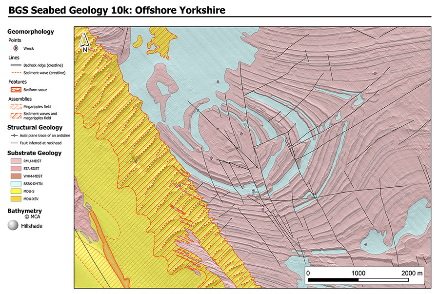
BGS Seabed Geology 10K: offshore Yorkshire. BGS © UKRI.
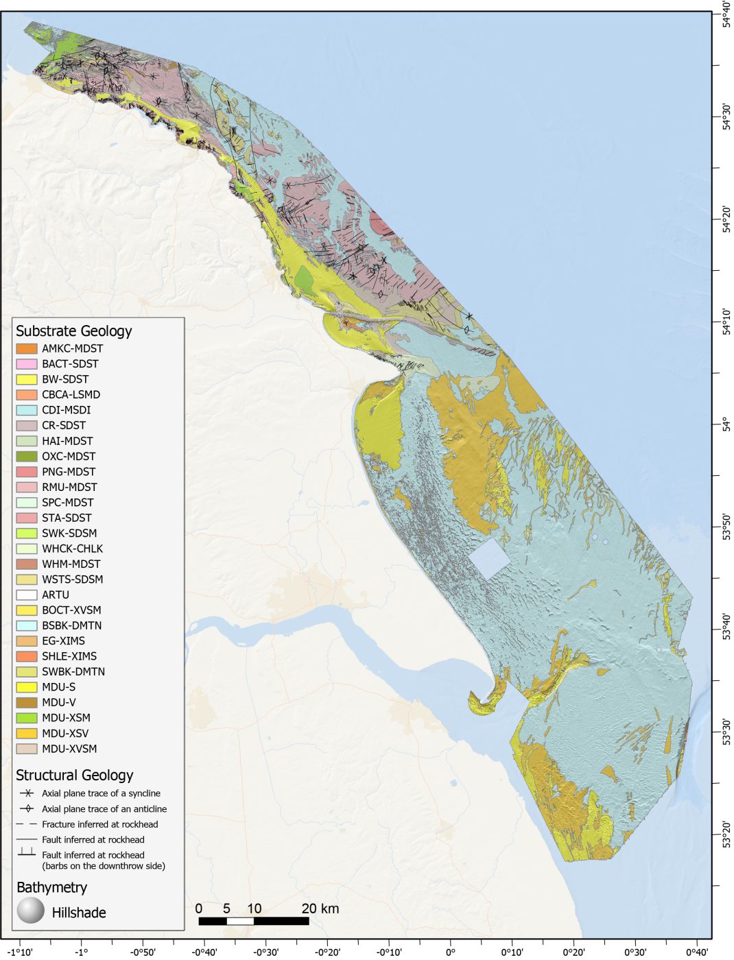
Substrate and structural geology from the full offshore Yorkshire map area. BGS © UKRI.
The maps are based primarily on high-resolution bathymetry data collected through the Maritime and Coastguard Agency’s UK Civil Hydrography Programme. They are further informed by acoustic backscatter data, sediment cores and grab samples, seismic data, and existing onshore and offshore map products (both BGS mapsand publicly available academic and industry products).

The geological character of the seabed and shallow subsurface is often complex, but is not well captured by currently available resources.
By applying a consistent approach nationally, incorporating both classical and innovative mapping approaches, these map products offer a unique resource, providing an excellent insight into complex geology, as well as active environmental processes.
Dayton Dove, BGS Marine Geoscientist.
BGS is among other public and government organisations to have joined the UK Centre for Seabed Mapping (UK CSM), helping to boost marine data and mapping standards. Improved geospatial resources will also provide important evidence for policy and decision makers, who need to consider the increasing demands placed on the marine environment from recreation, marine conservation and protection, resource development, and fisheries.
As well as providing important baseline datasets that can underpin efficiency in marine infrastructure projects, such as siting offshore renewables, the analysis and mapping process also leads to interesting new findings, providing the potential for genuine discovery.
Dayton Dove, BGS Marine Geoscientist.
The maps are available from BGS under the fine-scale maps section of the Offshore GeoIndex and are designed to be viewed at 1:10 000 scale, or offline as downloadable shapefiles.
Other areas to be added as the mapping programme progresses include offshore Orkney, East Anglia, and further areas of offshore Wales.
Other maps in this series:
Relative topics
Related news

Updated geological assessment of the Southern North Sea set to underpin future offshore infrastructure development
25/03/2026
The first regional assessment for 30 years will support offshore marine and subsurface planning for the UK’s low-carbon energy infrastructure, including the 2030 target of 45 to 50 GW generated through offshore wind.

New research could help provide a more reliable water supply for millions in rural Africa
24/03/2026
A new BGS-led study has revealed crucial insights into the longstanding challenges affecting the reliability and performance of rural water supply infrastructure in sub-Saharan Africa.

UK Critical Minerals Intelligence Centre 2026 showcase
Event on 31/03/2026
A special live webinar with the team from the Critical Minerals Intelligence Centre showcasing the latest research from 2026 on copper, the future of digital, and what’s next for the criticality assessment. A recording of the event is now available.

PhD adventures in Copenhagen, Denmark: revealing past recovery processes of tropical forest systems through ancient environmental DNA
12/03/2026
PhD student Chris Bengt visited the University of Copenhagen to carry out very delicate extraction of aeDNA from lake-sediment cores, in the hopes of unlocking the secrets of past volcanic eruptions.

Call for new members and Chair to join the NERC facilities steering committees
25/02/2026
New members are needed to join the committees over the next four years.

Your views wanted: developing a geothermal energy subsurface data portfolio
24/02/2026
BGS is aiming to support the growth of the sector by providing the best-available, location-specific geothermal and ground source heat information as an accessible product or service.

Map of BGS BritPits showing the distribution of worked mineral commodities across the country
18/02/2026
BGS’s data scientists have generated a summary map of the most commonly extracted mineral commodities by local authority area, demonstrating the diverse nature of British mineral resources.

MARC Conference 2025: highlighting the importance of conferences to PhD students
16/02/2026
BGS and University of Nottingham PhD student Paulina Baranowska shares her experience presenting her research on nuclear forensics at her first international conference.

Funding awarded to map the stocks and flows of technology metals in everyday electronic devices
12/02/2026
A new BGS project has been awarded Circular Electricals funding from Material Focus to investigate the use of technology metals in everyday electrical items.

New UK/Chile partnership prioritises sustainable practices around critical raw materials
09/02/2026
BGS and Chile’s Servicio Nacional de Geología y Minería have signed a bilateral scientific partnership to support research into critical raw materials and sustainable practices.