First national-scale groundwater model in Great Britain developed
BGS has developed a new model that provides a unique tool for simulating groundwater resources at a national scale.
14/05/2024 By BGS Press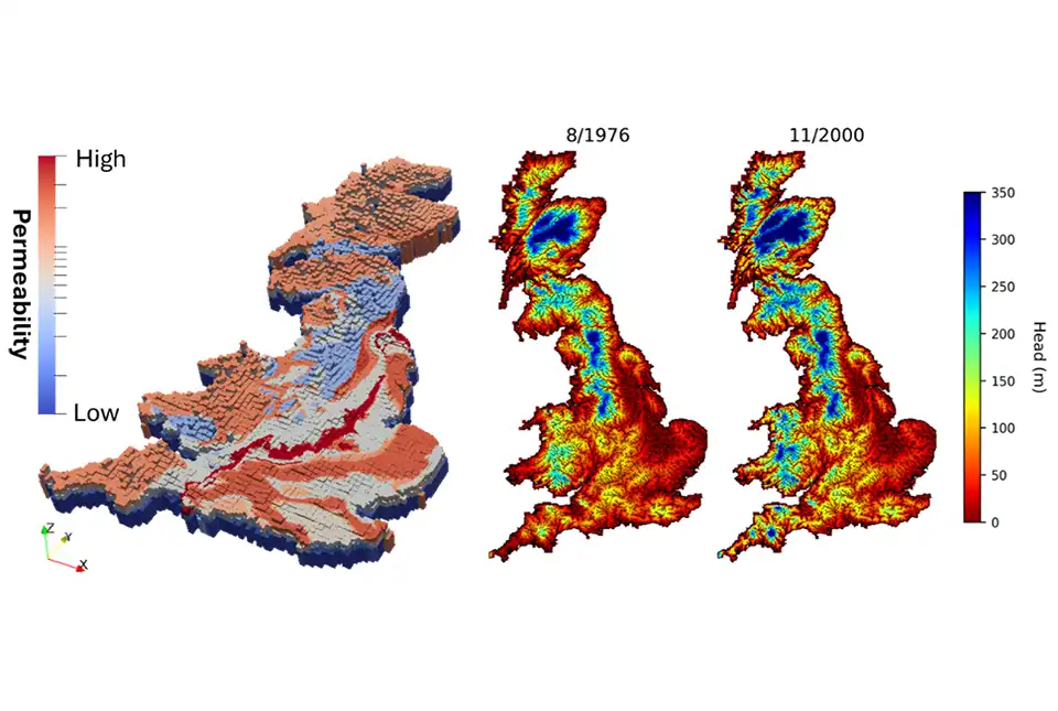

Groundwater accounts for the largest volume of liquid fresh water on Earth. It represents an essential resource for public and private supply, agriculture, industry and recreation around the world.
Groundwater flow can be visually shown through computer models, which helps us understand temporal variations in groundwater levels and interactions between groundwater and surface waters.
The British Groundwater Model (BGWM) is the first integrated groundwater model covering Great Britain to simulate transient groundwater dynamics and surface water/groundwater interactions at the national scale. The model provides a tool for a general assessment of groundwater resources in British aquifers and for improving current representations of groundwater flow in existing UK-focused land-surface and water-quality models.
BGWM uses the MODFLOW 6 code and includes British 3D geology. Model parameters were calibrated against measured groundwater levels and estimated baseflows using the PEST code.
The next phase of development will involve increasing the sophistication of the parameterisation, as well as a more realistic simulation of aquifer–marine interactions (coastal processes). By undertaking this future work, the BGWM will be improved so that it will become a robust decision support tool to test different solutions in the context of a changing population and climate.

This model represents the first attempt at simulating British groundwater systems as a whole. This is a tool that will be used to address a wide range of problems related to the use and conservation of groundwater resources at the national scale.
Marco Bianchi, BGS Principal Groundwater Modeller.
This model is the culmination of dedication and hard work from many BGS colleagues over the last five years. It gives the UK groundwater community the ability to address national-scale groundwater resources questions for the first time.
Andrew Hughes, BGS: manager of the Hydro-JULES research programme.
Further reading
Funding
The development of the BGWM was supported by the Hydro-JULES research programme through NERC National Capability funding. The programme, which aims to improve the understanding and simulation of the terrestrial hydrological cycle for the British mainland and global scales, is led by:
- UK Centre for Ecology & Hydrology
- BGS
- National Centre for Atmospheric Science
- National Centre for Earth Observation
Relative topics
Related news

Updated national 3D model will determine the depth to the solid bedrock beneath our feet
13/07/2026
The BGS Superficial Deposit Thickness Model now includes an elevation model of geological rockhead for the first time, providing important data for civil engineers, geoscientists and environmental scientists.

New geological mapping underway to help manage flooding along the River Tweed
08/07/2026
Scientists are surveying the Tweed catchment for the first time in over 100 years to enhance understanding of localised groundwater and improve flood forecasting.

New geological maps of Berwick-upon-Tweed to help future-proof natural water supply
20/05/2026
Scientists have mapped the geology under the town to better understand the groundwater system to inform decisions around abstraction.

Updated geological assessment of the Southern North Sea set to underpin future offshore infrastructure development
25/03/2026
The first regional assessment for 30 years will support offshore marine and subsurface planning for the UK’s low-carbon energy infrastructure, including the 2030 target of 45 to 50 GW generated through offshore wind.

New research could help provide a more reliable water supply for millions in rural Africa
24/03/2026
A new BGS-led study has revealed crucial insights into the longstanding challenges affecting the reliability and performance of rural water supply infrastructure in sub-Saharan Africa.

Map of BGS BritPits showing the distribution of worked mineral commodities across the country
18/02/2026
BGS’s data scientists have generated a summary map of the most commonly extracted mineral commodities by local authority area, demonstrating the diverse nature of British mineral resources.

Extensive freshened water confirmed beneath the ocean floor off the coast of New England for the first time
09/02/2026
BGS is part of the international team that has discovered the first detailed evidence of long-suspected, hidden, freshwater aquifers.

Can sandstones under the North Sea unlock the UK’s carbon storage potential?
02/02/2026
For the UK to reach its ambitious target of storing 170 million tonnes of carbon dioxide per year by 2050, it will need to look beyond the current well-studied geographical areas.

Quaternary UK offshore data digitised for the first time
21/01/2026
The offshore wind industry will be boosted by the digitisation of a dataset showing the Quaternary geology at the seabed and the UK’s shallow subsurface.

Hole-y c*@p! How bat excrement is sculpting Borneo’s hidden caves
23/12/2025
BGS researchers have delved into Borneo’s underworld to learn more about how guano deposited by bats and cave-dwelling birds is shaping the subsurface.

New geological maps of the Yorkshire Wolds to better inform groundwater management and policy decisions
17/12/2025
The new mapping provides crucial data on localised geological issues that may assist in protecting water supplies.

New 3D model to help mitigate groundwater flooding
08/12/2025
BGS has released a 3D geological model of Gateshead to enhance understanding of groundwater and improve the response to flooding.