BGS to deliver three-year groundwater flood forecasting service to support emergency response to flooding
BGS is delivering a national-scale early warning system for groundwater flooding, alongside the Environment Agency and the Met Office.
29/11/2021 By BGS Press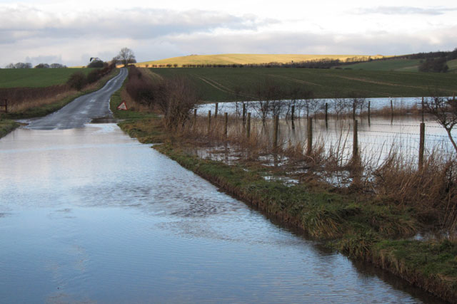

BGS has been appointed to forecast groundwater flooding for the Flood Forecasting Centre (FFC) until 2024.
BGS will deliver a three-year groundwater flood forecasting service (GWFFS), providing a national-scale early warning system for England for groundwater flooding.
The service officially went live at the beginning of November 2021 and is being used by the FFC to help inform their daily flood guidance statements, which are delivered to support the Category 1 and 2 emergency response community.
Groundwater flooding represents a significant part of the overall flood risk in the UK, but is challenging to forecast as it results from subsurface flow processes that are hard to observe and difficult to characterise.

The service not only builds on our expertise in national groundwater flood mapping and modelling, but also our continued collaboration with the Met Office and Environment Agency in delivering operational groundwater forecasts for other services such as the UK Hydrological Outlook. At the heart of the system is our AquiMod groundwater model software, which allows us to provide skillful forecasts quickly and at an appropriate scale, helping the FCC to deliver relevant information to those that need it.
The opportunity to provide essential data of this scale to the FCC, which combines meteorological and hydrological expertise with extensive regional- and local-scale knowledge and community engagement practices, will ensure there is a reliable link between science and the impact that flooding has on everyday lives.
Dr Jonathan Mackay, BGS groundwater flood forecasting service project lead.
The FCC, which is a working partnership between the Environment Agency and Met Office, uses flood forecast information to assess the likelihood, location and scale of groundwater flooding.
The GWFFS forms part of the FCC’s commitment to continually improve its ability to deliver skillful flood forecasts with more targeted information for emergency flood responders.
It’s great to have the expertise and skills of British Geological Survey hydrogeologists on board as partners to support the FFC. This service will enable the FFC to deliver timely and accurate groundwater flood forecasts to be used to assist emergency responders with tactical, strategic and operational planning decisions.
Steve Stanbridge, Flood Forecasting Centre.
Relative topics
Related news

New NERC-funded project empowers young people to engage with environmental science
23/07/2026
BGS is part of a new, collaborative project, funded through NERC’s ‘Opening up the environment’ programme, helping the environmental research community become more accessible.

Delving deep into mountains for future water security
16/07/2026
A BGS-led project is using new water-tracing investigation methods, geophysics and modelling to understand how water moves from mountains to the lowlands, helping to improve water security for billions of people.

Updated national 3D model will determine the depth to the solid bedrock beneath our feet
13/07/2026
The BGS Superficial Deposit Thickness Model now includes an elevation model of geological rockhead for the first time, providing important data for civil engineers, geoscientists and environmental scientists.

UK’s world-class research organisations launch new collective
10/07/2026
The launch of the National Research Organisations Group brings together more than 100 science leaders to provide an authorativive voice on science, research policy and long-term investment.

Cheshire Geoenergy Observatory releases key geological datasets for UK thermal energy storage scheme design
09/07/2026
A new report and data packs from BGS will provide a unique resource for scientists working on the geology and hydrogeology of the Sherwood Sandstone Formation, an important aquifer and reservoir rock.

New geological mapping underway to help manage flooding along the River Tweed
08/07/2026
Scientists are surveying the Tweed catchment for the first time in over 100 years to enhance understanding of localised groundwater and improve flood forecasting.

Geological research in North Sea helping to safeguard subsea cables
06/07/2026
Subsea power and telecommunications cables are critical to the UK’s energy infrastructure and global connectivity, yet they remain vulnerable to damage from ship anchors, fishing activity and natural hazards.

UK Critical Minerals Intelligence Centre makes recommendations for the next UK criticality assessment
01/07/2026
CMIC has outlined the enhancements made to the next assessment update to ensure it is better tailored to the structure of the UK economy.

From archive to discovery: historical mineral reports support gold exploration in Scotland
25/06/2026
Digitised geological records show potential to unlock untapped mineral resources in Ardlochan, Argyllshire.

UK and Philippines scientists investigate natural hydrogen generation processes at atomic scale
22/06/2026
BGS researchers were granted access to use the Diamond Light Source facility in order to study hydrogen in light brighter than the sun.

Shortage of end-of-life materials presents challenge to UK critical minerals security
17/06/2026
A new report by the UK Critical Minerals Intelligence Centre reveals insufficient end-of-life material stocks present a supply risk over the coming decade, but offer significant long-term potential to meet critical mineral demand through recycling.

UK geothermal catalogue receives update
16/06/2026
BGS releases the second digital version of the UK geothermal catalogue of subsurface temperature and rock thermal conductivity measurements and heat flow calculations.