BGS data supports new tool to track geological changes in abandoned coal mines
BGS data supports new tool to track geological changes in abandoned coal mines.
20/11/2020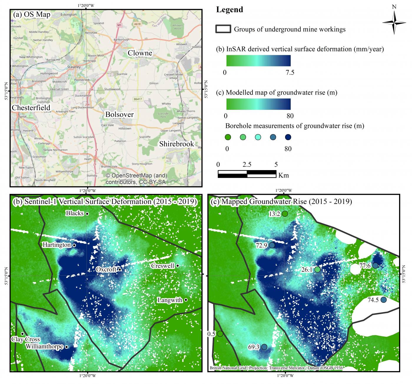

BGS is part of a multi-disciplinary team led by the University of Nottingham to develop a remote monitoring tool designed to help authorities manage public safety and environmental issues in recently abandoned coal mines.
The tool uses satellite radar imagery to capture millimeter-scale measurements of changes in terrain height. These measurements, when integrated with geological process models, can be used to monitor and forecast groundwater levels and changes in geological conditions deep below the earth’s surface in former mining areas. Ultimately this can help forecast where surface discharge of mine water may occur.
The study uses an advanced InSAR technique, called Intermittent Small Baseline Subset (ISBAS), developed by the University of Nottingham and Terra Motion Ltd and uses geological data provided by the BGS.
The method has been implemented over Nottinghamshire coalfields and the findings published in a paper ‘Modelling groundwater rebound in recently abandoned coalfields using DInSAR’ in the journal Remote Sensing of the Environment.
The team hopes to integrate results into an existing screening tool developed by the Environment Agency and Coal Authority to help local planning authorities, developers and consultants design sustainable drainage systems in coalfield areas, with potential to be scaled to coalfields across the UK.
The research was led by University of Nottingham PhD, David Gee and funded by the GeoEnergy Research Centre and Terra Motion Limited. ENVISAT and Sentinel-1 SAR data were provided by the European Space Agency with geological data by BGS and hydrogeological data by the Coal Authority.
Luke Bateson and Alessandro Novellino from the BGS Earth Observation and Geodesy capability have supported the geological interpretation and modelling of the InSAR results.
Read the full story on the University of Nottingham website
You can read more about the Interferometric Synthetic Aperture Radar (InSAR) technique from BGS Remote Sensing Geologist, Alessandro Novellino in ‘Mapping Ground Deformation from Space’, on the British Geological Survey blog.

Luke Bateson
Acting head of shallow geohazards and Earth observation; head of geodesy and remote sensing (Keyworth)

Dr Alessandro Novellino
Remote sensing geoscientist
Relative topics
Related news

New NERC-funded project empowers young people to engage with environmental science
23/07/2026
BGS is part of a new, collaborative project, funded through NERC’s ‘Opening up the environment’ programme, helping the environmental research community become more accessible.

Delving deep into mountains for future water security
16/07/2026
A BGS-led project is using new water-tracing investigation methods, geophysics and modelling to understand how water moves from mountains to the lowlands, helping to improve water security for billions of people.

Updated national 3D model will determine the depth to the solid bedrock beneath our feet
13/07/2026
The BGS Superficial Deposit Thickness Model now includes an elevation model of geological rockhead for the first time, providing important data for civil engineers, geoscientists and environmental scientists.

UK’s world-class research organisations launch new collective
10/07/2026
The launch of the National Research Organisations Group brings together more than 100 science leaders to provide an authorativive voice on science, research policy and long-term investment.

Cheshire Geoenergy Observatory releases key geological datasets for UK thermal energy storage scheme design
09/07/2026
A new report and data packs from BGS will provide a unique resource for scientists working on the geology and hydrogeology of the Sherwood Sandstone Formation, an important aquifer and reservoir rock.

New geological mapping underway to help manage flooding along the River Tweed
08/07/2026
Scientists are surveying the Tweed catchment for the first time in over 100 years to enhance understanding of localised groundwater and improve flood forecasting.

Geological research in North Sea helping to safeguard subsea cables
06/07/2026
Subsea power and telecommunications cables are critical to the UK’s energy infrastructure and global connectivity, yet they remain vulnerable to damage from ship anchors, fishing activity and natural hazards.

UK Critical Minerals Intelligence Centre makes recommendations for the next UK criticality assessment
01/07/2026
CMIC has outlined the enhancements made to the next assessment update to ensure it is better tailored to the structure of the UK economy.

From archive to discovery: historical mineral reports support gold exploration in Scotland
25/06/2026
Digitised geological records show potential to unlock untapped mineral resources in Ardlochan, Argyllshire.

UK and Philippines scientists investigate natural hydrogen generation processes at atomic scale
22/06/2026
BGS researchers were granted access to use the Diamond Light Source facility in order to study hydrogen in light brighter than the sun.

Shortage of end-of-life materials presents challenge to UK critical minerals security
17/06/2026
A new report by the UK Critical Minerals Intelligence Centre reveals insufficient end-of-life material stocks present a supply risk over the coming decade, but offer significant long-term potential to meet critical mineral demand through recycling.

UK geothermal catalogue receives update
16/06/2026
BGS releases the second digital version of the UK geothermal catalogue of subsurface temperature and rock thermal conductivity measurements and heat flow calculations.