10 years on: the 2011 Great East Japan Earthquake and Tsunami
In remembrance, Prof David Tappin discusses the importance of tsunami anniversaries
11/03/2021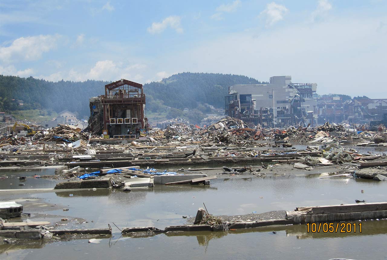

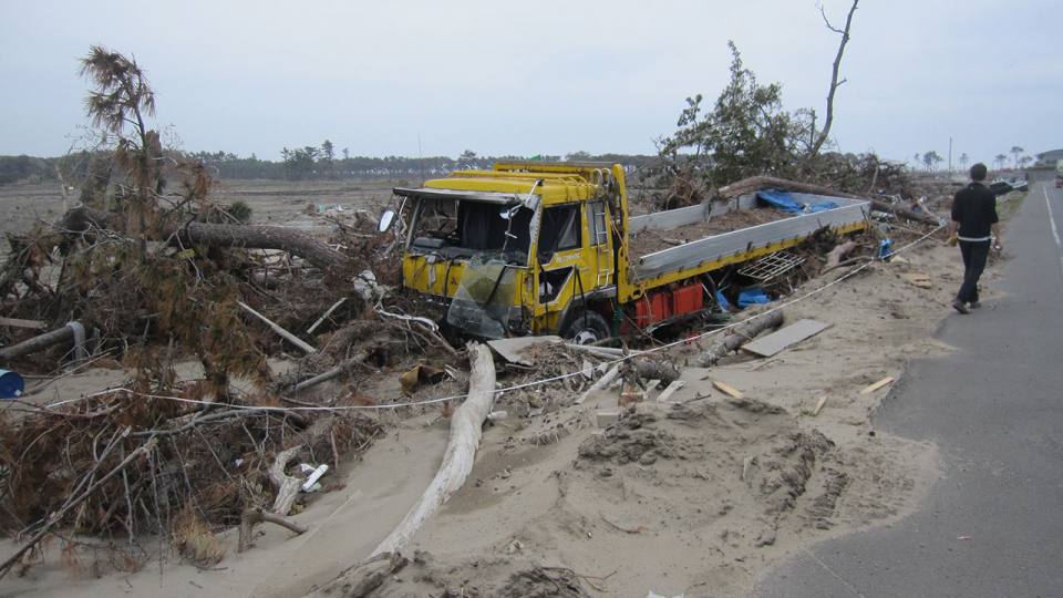
It is a time for remembrance; on the 11th March 2011 at 2.46 in the afternoon, a 9.1 magnitude earthquake off the east coast of Honshu Island, Japan caused a tsunami up to 40 metres high that flooded local coastlines, causing over 18,500 fatalities and over 280 billion dollars’ worth of damage. This was the most recent devastating tsunami, and its magnitude was a major surprise. Seven years previously, in 2004, in the Indian Ocean, another surprise earthquake generated tsunami resulted in over 220,000 deaths. Afterward, there was still some uncertainty over where these events would strike, and Japan demonstrated that the hazard was global but, also, that their mechanisms (earthquake or submarine landslide) might not be as clear cut as first observations might suggest.
Over the past 20 years there have been a number of devastating tsunamis, which suggests that we are living in the ‘Age of Tsunamis’. Perhaps the first of these important recent events was in 1998, in Papua New Guinea, where 2,200 people died in tsunami up to 15 metres high. Here the earthquake magnitude 7.1 was too small to explain the tsunami height, and for the first time, a submarine sediment failure, termed a slump was proved to explain the tsunami. At that time submarine landslides were not considered effective at causing hazardous tsunamis; and the landslide was identified by new technology available to map the seabed, with the surveys mainly funded by Japan. Six years after the Papua New Guinea tsunami, in December 2004 over 220,000 people died in the devastating tsunami that struck the eastern Indian Ocean. Then in March 2011 the Japan tsunami struck. Here, although the earthquake generated most of the tsunami along the low-lying Sendai Plain, the very high, up to 40 metre elevations, father north along the ‘Sanriku’ coast have been proposed as being from a secondary, submarine landslide. This is still not completely certain, but without the Papua New Guinea tsunami of 1998, it would have been an impossible idea.
May 2011 – overview of tsunami damage in Minamisanriku, North Honshu Island. Source: © David Tappin / BGS
The tsunami events of 1998, 2004 and 2011 were catastrophic, with many hundreds of thousands of fatalities, but they all resulted in improved understandings of tsunami mechanisms and tsunami hazard which led to improved mitigation; there are now tsunami warning systems in all the world’s major oceans, whereas in 2004, only the Pacific was covered. The recent earthquake event in New Zealand testifies to the importance of these global warning systems; here there was no dangerous tsunami, but if there had been many lives would have saved.
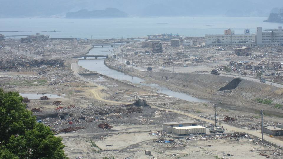
Tsunami 2011 damage on the Sendai Plain. Source: © David Tappin / BGS
Our knowledge base today, to plan and respond to tsunamis is far beyond anything considered possible 20 years ago. The result is that all the major ocean basins have warning systems. Devastating tsunami events are, fortunately, quite rare, but not impossible. In this context rather than letting time subdue our memories of these devastating events, anniversaries are important, both in remembering and honouring those who died and suffered in them, but also in reminding us that they will happen again in the future, and when they do we will be aware and prepared. Today’s anniversary of the Japan 2011 tsunami is critically important in this respect.
References:
Tappin, D.R., Evans, H.M., Jordan, C.J., Richmond, B., Sugawara, D., Goto, K., 2012. Coastal changes in the Sendai area from the impact of the 2011 Tōhoku-oki tsunami: Interpretations of time series satellite images, helicopter-borne video footage and field observations. Sedimentary Geology 282, 151-174.
Tappin, D.R., Grilli, S.T., Harris, J.C., Geller, R.J., Masterlark, T., Kirby, J.T., Shi, F., Ma, G., Thingbaijam, K.K.S., Mai, P.M., 2014. Did a submarine landslide contribute to the 2011 Tohoku tsunami? Marine Geology 357, 344-361
David Tappin is a BGS scientist, and Visiting Professor at University College, London, who has researched tsunamis for over 20 years, including those in Papua New Guinea, the Indian Ocean and Indonesia. After the Japan 2011 tsunami struck, he participated in a number of post-tsunami field surveys in Japan and published on the possibility that the tsunami was in part caused by a submarine landslide. Most recently he has researched the Indonesian tsunamis of 2018 in Palu, Sulawesi and the Sunda Strait.
Prof David Tappin
Principal researcher
Relative topics
Latest news

New NERC-funded project empowers young people to engage with environmental science
23/07/2026
BGS is part of a new, collaborative project, funded through NERC’s ‘Opening up the environment’ programme, helping the environmental research community become more accessible.

Delving deep into mountains for future water security
16/07/2026
A BGS-led project is using new water-tracing investigation methods, geophysics and modelling to understand how water moves from mountains to the lowlands, helping to improve water security for billions of people.

Updated national 3D model will determine the depth to the solid bedrock beneath our feet
13/07/2026
The BGS Superficial Deposit Thickness Model now includes an elevation model of geological rockhead for the first time, providing important data for civil engineers, geoscientists and environmental scientists.

UK’s world-class research organisations launch new collective
10/07/2026
The launch of the National Research Organisations Group brings together more than 100 science leaders to provide an authorativive voice on science, research policy and long-term investment.

Cheshire Geoenergy Observatory releases key geological datasets for UK thermal energy storage scheme design
09/07/2026
A new report and data packs from BGS will provide a unique resource for scientists working on the geology and hydrogeology of the Sherwood Sandstone Formation, an important aquifer and reservoir rock.

New geological mapping underway to help manage flooding along the River Tweed
08/07/2026
Scientists are surveying the Tweed catchment for the first time in over 100 years to enhance understanding of localised groundwater and improve flood forecasting.

Geological research in North Sea helping to safeguard subsea cables
06/07/2026
Subsea power and telecommunications cables are critical to the UK’s energy infrastructure and global connectivity, yet they remain vulnerable to damage from ship anchors, fishing activity and natural hazards.

UK Critical Minerals Intelligence Centre makes recommendations for the next UK criticality assessment
01/07/2026
CMIC has outlined the enhancements made to the next assessment update to ensure it is better tailored to the structure of the UK economy.

From archive to discovery: historical mineral reports support gold exploration in Scotland
25/06/2026
Digitised geological records show potential to unlock untapped mineral resources in Ardlochan, Argyllshire.

UK and Philippines scientists investigate natural hydrogen generation processes at atomic scale
22/06/2026
BGS researchers were granted access to use the Diamond Light Source facility in order to study hydrogen in light brighter than the sun.

Shortage of end-of-life materials presents challenge to UK critical minerals security
17/06/2026
A new report by the UK Critical Minerals Intelligence Centre reveals insufficient end-of-life material stocks present a supply risk over the coming decade, but offer significant long-term potential to meet critical mineral demand through recycling.

UK geothermal catalogue receives update
16/06/2026
BGS releases the second digital version of the UK geothermal catalogue of subsurface temperature and rock thermal conductivity measurements and heat flow calculations.