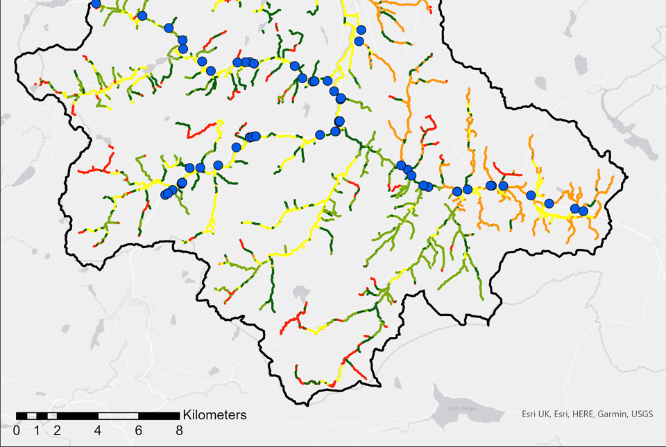

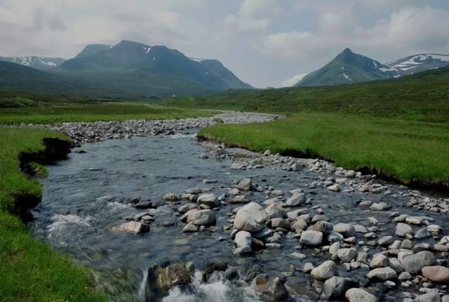
BGS GeoScour Tier 3 catchment data for Conwy. Source: ESRI UK, ESri, HERE, Garmin, USGS
BGS GeoScour
-
Tier 1: 1:625 000
Tier 2: 1:250 000
Tier 3: 1:50 000 - Great Britain
- Open / Premium
The BGS GeoScour datasets provide a generalised overview of the natural characteristics and properties of catchment and riverine environments for the assessment of river scour in Great Britain.
Key information
- Scale:
- Tier 1: 1:625 000
Tier 2: 1:250 000
Tier 3: 1:50 000 - Coverage:
- Great Britain
- Availability:
- Open / Premium
- Price:
Tier 1 and 2 available via Open Government Licence (OGL)
Tier 3 priced per catchment based on river length
Band 0.5 (catchment with river length less than 500 kilometres): £56.78
Band 1 (catchment with river length less than 500 kilometres): £113.56
Band 2 (catchment with river length between 500-1400 kilometres) : £227.12
Band 3 (catchment with river length greater than 1400 kilometres): £340.67
- Format:
- Format: GIS polyline and point data (ESRI. Other formats available on request)
- Uses:
- Local-level to Regional-level use
- Themes:
- Hazards, Hydrogeology
- Sector:
- Infrastructure, Weathering and erosion
The BGS GeoScour datasets provide a generalised overview of the natural characteristics and properties of catchment and riverine environments for the assessment of river scour in Great Britain.
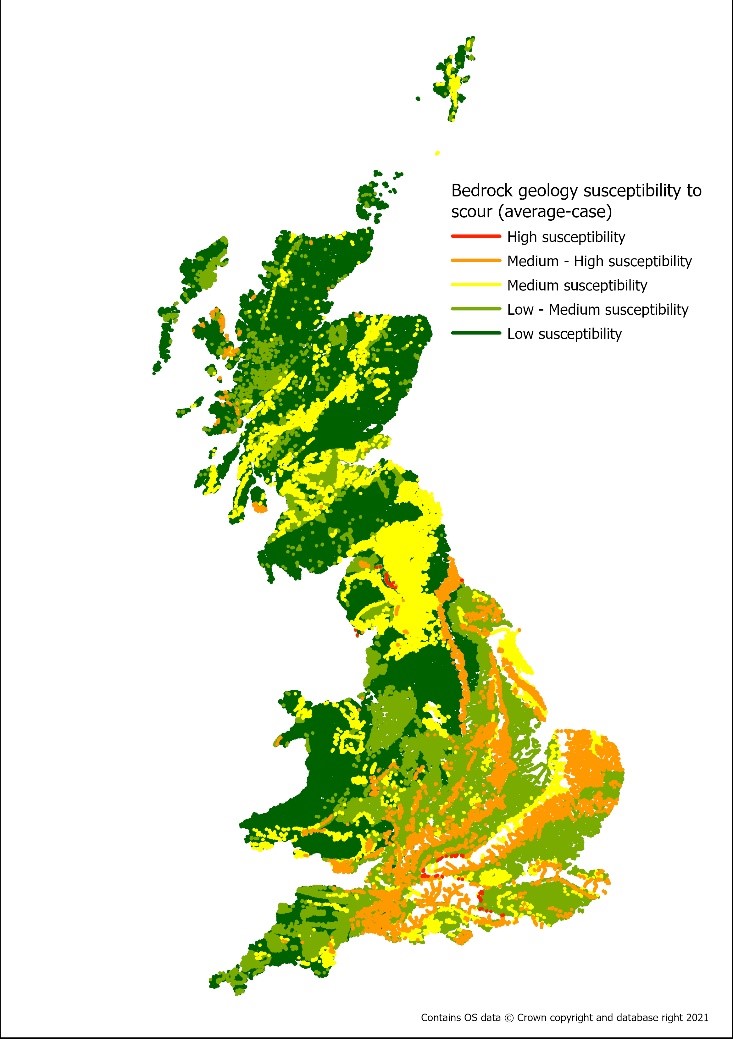
Tier 3 example: bedrock susceptibility. BGS © UKRI – Contains OS data © Crown copyright 2021.
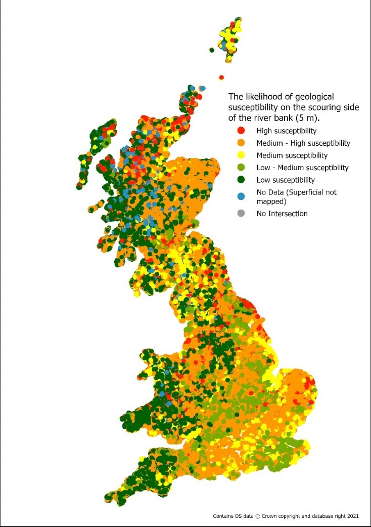
Tier 3 example: lateral erosion. BGS © UKRI – Contains OS data © Crown copyright 2021.
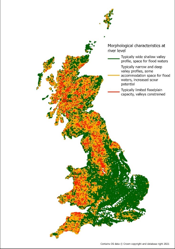
Tier 3 example: River-morphology. BGS © UKRI – Contains OS data © Crown copyright 2021.
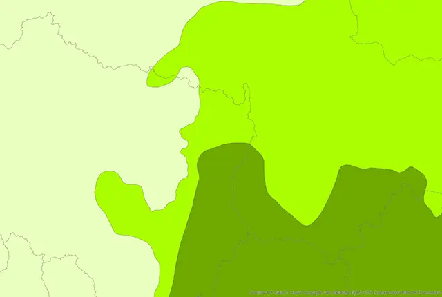
Geoscour Premium coverage map. BGS © UKRI – Contains OS data © Crown copyright 2020.
This dataset
The GeoScour Premium comprises the most detailed, tier 3 suite of datasets in geographical information system (GIS) format. Tier 3 contains a suite of 4 datasets including:
- River geological susceptibility
- Surface geology susceptibility
- Bedrock geology susceptibility (new in V2)
- River geological properties
- River morphology
- River lateral erosion (new in V2)
The datasets are provided as river lines (polylines) and one as point data which are described using straightforward classifications, enabling a scour susceptibility assessment.
The Premium licensed dataset contains all the datasets in GeoScour Open plus 4 additional, detailed layers at the tier 3 (riverine; 1:50 000) level. Tier 1 and 2 data can also be viewed via the GeoIndex.

The BGS GeoScour datasets provide a generalised overview of the natural characteristics and properties of catchment and riverine environments for the assessment of river scour in Great Britain.
River geological susceptibility data
This assessment is provided as two datasets:
- Surface Geology Susceptibility: an assessment of the uppermost deposits along the river. These data could provide susceptibility classifications for all deposits at surface, therefore showing superficial deposits where present or bedrock deposits where no superficial is present.
- Bedrock Geology Susceptibility: an assessment of the underlying bedrock deposits for susceptibility to scour. These data assess the susceptibility to scour of the bedrock geology whether superficial deposits are present or not. This classification is important especially in areas where the bedrock is a higher susceptibility to scour such as soluble rocks. Even where superficial deposits are present, it is important to understand the underlying properties of the bedrock as more frequent or extreme flood events might remove the overlying sediment to expose the bedrock to erosion.
Both analyses are provided as average-case, best-case and worst-case parameters to convey the variation and heterogeneous behaviour of geological deposits and to allow the user to consider both end members for scour potential according to their needs. These data layers identify the primary geological properties influencing scour potential including material density, strength (in line with technical engineering terminology BS5930:2015), and mineralogy.
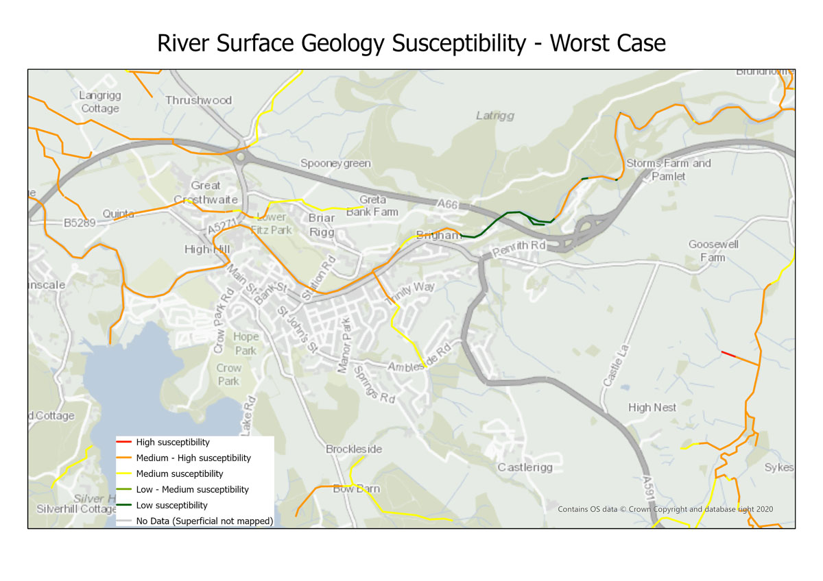
GeoScour Tier 3: River surface geology susceptibility (worst case). BGS © UKRI – Contains OS data © Crown copyright 2020.
River geological properties data
This dataset provides the representation or coverage of four geological properties (bedrock, strength, density and mineralogy of materials) per river reach. It assesses the percentage length of each type of geological property (different densities, strengths, mineralogy) and the percentage length of bedrock for each individual river reach.
River morphology layer data
The river morphology data layer contains information on the key morphological characteristics of the catchment at the riverine level. These include the flood accommodation space available per river reach, the vertical fall of the river per reach and the sinuosity factor.
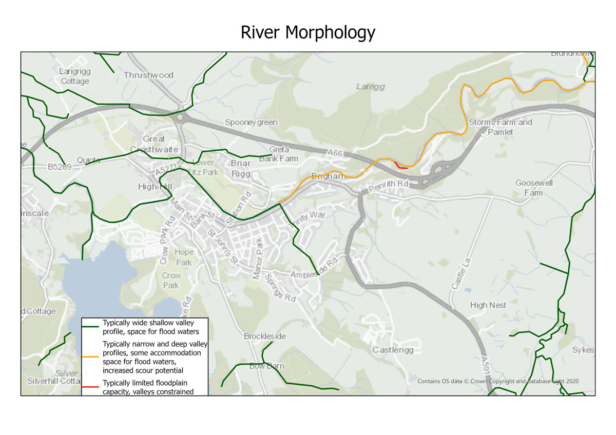
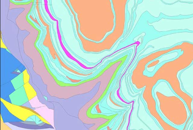
GeoScour Tier 3: River morphology. BGS © UKRI – Contains OS data © Crown copyright 2020.
River lateral erosion
This dataset provides an assessment of any lateral change in susceptibility to scour, which is calculated on the scouring bank of the river course in the direction of river flow. An interpretation of the geology and its susceptibility to scour is assessed over set distances using transects perpendicular to the river line (OS WatercourseLink 2021).
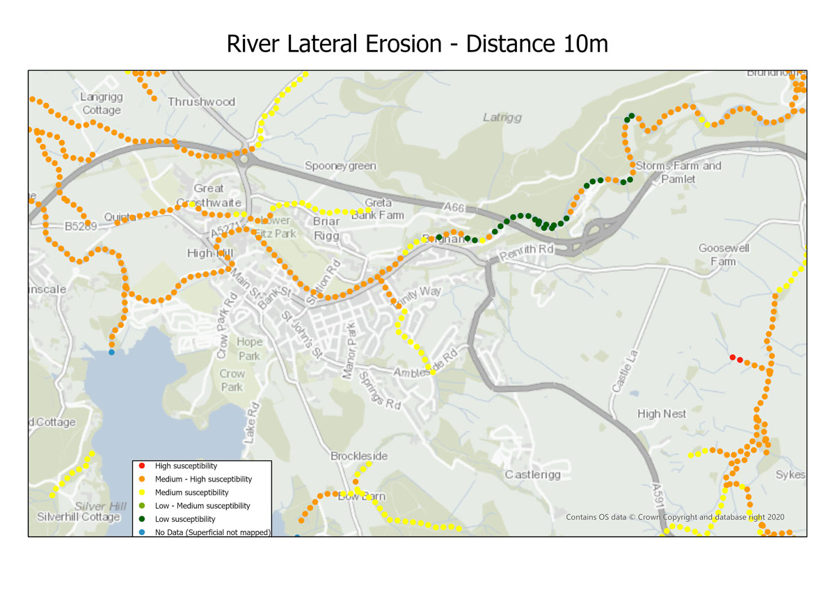
GeoScour Tier 3: River lateral erosion susceptibility. BGS © UKRI – Contains OS data © Crown copyright 2020.
The assessment is based on the worst-case geological susceptibility data and considers transects up to 200 m from the line of the river. This assessment allows owners of riverside assets, such as road or pipeline infrastructure, to assess the location of any change in geology and therefore any change in susceptibility.
Relative topics
Related content
BGS GeoScour: bridging the river erosion data gap
31/08/2022
The geological properties of bedrock and superficial deposits that make up riverbeds and banks are fundamental controls on the susceptibility of any given river reach to scouring.
River erosion: the forgotten hazard of flooding
03/08/2022
Impacts from flood events can be widespread, long-lasting and extremely costly. The UK Government and environmental protection agencies continue to invest heavily in mitigation measures, as well as trying to predict which areas are most at risk.
GeoScour dataset launch event
Event on 08/09/2022
Access a recording of our 30-minute webinar for an overview of river scour and its associated river erosion hazards, including surface geology susceptibility and bedrock geology susceptibility.
BGS GeoScour Open
The BGS GeoScour Open datasets provide a generalised overview of the natural characteristics and properties of catchment and riverine environments for the assessment of river scour in Great Britain.
BGS GeoScour Premium
The BGS GeoScour datasets provide a generalised overview of the natural characteristics and properties of catchment and riverine environments for the assessment of river scour in Great Britain.
You may also be interested in
BGS Geology 50K
This generalised digital geological data is based on BGS’s 1:50 000 and 1:63 360-scale maps. Covering almost all of Great Britain, it provides a detailed local to regional description of geology and underpins many of our national map services and products. Lithostratigraphic nomenclature is updated to current usage.
BGS GeoScour Open
The BGS GeoScour Open datasets provide a generalised overview of the natural characteristics and properties of catchment and riverine environments for the assessment of river scour in Great Britain.
BGS GeoScour Premium
The BGS GeoScour datasets provide a generalised overview of the natural characteristics and properties of catchment and riverine environments for the assessment of river scour in Great Britain.
GeoCoast Premium
GeoCoast is an integrated GIS package of datasets designed to inform and support coastal management and adaptation.

Geological indicators of flooding
BGS has produced the geological indicators of flooding dataset from geological maps detailing the floodplains and coastal plains in Britain.