UK’s geomagnetic blind spots tackled with new observatories
Three new geomagnetic observatories have been installed across the UK to fill in the country’s 'blind spots' and tackle the risk posed by space weather.
28/07/2022 By BGS Press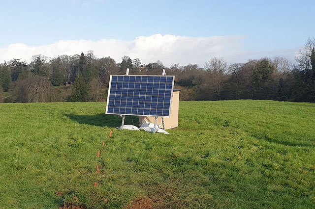

Three new underground geomagnetic observatories in County Fermanagh, Leicestershire and Sussex will detect and eventually help predict space weather, which can potentially disrupt power grids, satellite communications and the GPS on smartphones.
They were installed underground in quiet, rural locations by the BGS Geomagnetism team. The solar-powered observatories will collect data about Earth’s natural magnetic field and send it back to BGS in real-time, using the mobile phone network.
Why do we need new geomagnetic observatories?
Intense geomagnetic storms can have an adverse impact on technology like
power systems, satellite operations and smartphones.

The new magnetometers mean we now have full coverage of magnetic field change across the UK.
Very large geomagnetic storms produce widespread aurora. While beautiful, they have the potential to be incredibly disruptive.
They could cause power disruption and affect essential services like satellite communications and transport.
Now that we have monitors in our blind spots, we will better understand in detail where and what ground effects can occur and understand why they happened.
Dr Ciarán Beggan, BGS Geophysicist.
Britain has had geomagnetic observatories in Shetland, Eskdalemuir and
Devon since 1908, covering the country from north to south; the three new observatories will improve the breadth of measurements from west to east.
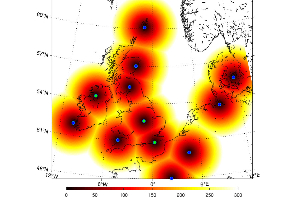
Zones of influence for the geomagnetic observatories.
The blue dots are existing observatories in the UK, Ireland and in northern Europe. The green dots are new UK observatories, three of which BGS installed in the past six months. The graded colouring from red to yellow shows the distance away from each location (up to 300 km away). No UK observatory is more than about 350 km (yellow colour) from its nearest neighbour and every part of the UK is within 200 km of an observatory.
The Aberdeen observatory is operated by Lancaster AuroraWatch, not BGS.
BGS © UKRI.
Mitigating a national risk
Severe space weather was included in the UK Government’s National Risk Register 2020.
Geomagnetic storms are one form of space weather. They interrupt essential
services by creating geoelectric fields in the subsurface, which then flow
into transformers, pipelines and railways, causing malfunctions.
Other effects include an increase in the density of the upper atmosphere (ionosphere), which disrupts radio waves passing through it. This leads to a loss of signal between the ground and satellites, affecting communications and the accuracy of global navigation satellite systems (GNSS). A huge number of technology systems rely on GNSS, including:
- phones
- trains
- self-driving vehicles
- timing for internet transactions
Major geomagnetic storms are relatively rare but, as Dr Beggan points out, they
have a pattern.
Major geomagnetic storms happen every 30 or 40 years in the UK, but we haven’t had a big one since 1989.
We live in a completely different society now, where we are all reliant on
continuous electricity supplies, smartphones and satellite communications — a major geomagnetic storm could significantly reduce those services.We’re currently moving into a stronger part of the solar cycle, which means the chance of large geomagnetic storms is greater.
Geomagnetic storms are currently hard to predict in terms of size or even arrival time from the Sun. Adding the new sensors means we are able to measure their effects on the ground in real-time and advise on the impact on technology.
Dr Ciarán Beggan, BGS Geophysicist.
Further reading
- Find out more about geomagnetism from BGS
Funding
The geomagnetic observatories were funded by UK Research and Innovation’s £20 million Space weather innovation, measurement, modelling and risk (SWIMMR) programme.
Relative topics
Media contact: Sarah McDaid (sarah@mcdaidpr.co.uk 07866789688)
How were the new sites selected?
Ciarán Beggan said: ‘We need a magnetically quiet, secure site. A magnetically quiet site must be at least 250 m from buildings, power lines and electric fences and 5 km from an electrified train line.
‘Ideally, it will have a south-facing aspect for the solar panel and 1 m of soil to allow the sensor to be buried. We ask permission from the landowner prior to installation. We want locations that are around 200–250 km from the existing observatories as this is the general “scale” of magnetic field changes during geomagnetic storms.
‘Fermanagh is the most westerly part of Northern Ireland. The Sussex site is relatively easterly and is part of an existing BGS facility at Herstmonceux. The Leicestershire site is approximately in the middle of England, equidistant between the observatories in Devon and Eskdalemuir.’
Examples of geomagnetic storms having adverse impact:
- 2022: Elon Musk’s SpaceX lost 40 satellites in one day as the result of a geomagnetic storm
- 2003: power outage in Sweden caused by geomagnetic storm
- 1989: Quebec 12-hour blackout caused by geomagnetic storm
- 1859: the ‘Carrington storm’, the biggest ever geomagnetic storm recorded, when people could see the northern lights in the tropics
- What if the Carrington storm happened today, in the satellite comms and smartphone era?
Related news

New NERC-funded project empowers young people to engage with environmental science
23/07/2026
BGS is part of a new, collaborative project, funded through NERC’s ‘Opening up the environment’ programme, helping the environmental research community become more accessible.

Delving deep into mountains for future water security
16/07/2026
A BGS-led project is using new water-tracing investigation methods, geophysics and modelling to understand how water moves from mountains to the lowlands, helping to improve water security for billions of people.

Updated national 3D model will determine the depth to the solid bedrock beneath our feet
13/07/2026
The BGS Superficial Deposit Thickness Model now includes an elevation model of geological rockhead for the first time, providing important data for civil engineers, geoscientists and environmental scientists.

UK’s world-class research organisations launch new collective
10/07/2026
The launch of the National Research Organisations Group brings together more than 100 science leaders to provide an authorativive voice on science, research policy and long-term investment.

Cheshire Geoenergy Observatory releases key geological datasets for UK thermal energy storage scheme design
09/07/2026
A new report and data packs from BGS will provide a unique resource for scientists working on the geology and hydrogeology of the Sherwood Sandstone Formation, an important aquifer and reservoir rock.

New geological mapping underway to help manage flooding along the River Tweed
08/07/2026
Scientists are surveying the Tweed catchment for the first time in over 100 years to enhance understanding of localised groundwater and improve flood forecasting.

Geological research in North Sea helping to safeguard subsea cables
06/07/2026
Subsea power and telecommunications cables are critical to the UK’s energy infrastructure and global connectivity, yet they remain vulnerable to damage from ship anchors, fishing activity and natural hazards.

UK Critical Minerals Intelligence Centre makes recommendations for the next UK criticality assessment
01/07/2026
CMIC has outlined the enhancements made to the next assessment update to ensure it is better tailored to the structure of the UK economy.

From archive to discovery: historical mineral reports support gold exploration in Scotland
25/06/2026
Digitised geological records show potential to unlock untapped mineral resources in Ardlochan, Argyllshire.

UK and Philippines scientists investigate natural hydrogen generation processes at atomic scale
22/06/2026
BGS researchers were granted access to use the Diamond Light Source facility in order to study hydrogen in light brighter than the sun.

Shortage of end-of-life materials presents challenge to UK critical minerals security
17/06/2026
A new report by the UK Critical Minerals Intelligence Centre reveals insufficient end-of-life material stocks present a supply risk over the coming decade, but offer significant long-term potential to meet critical mineral demand through recycling.

UK geothermal catalogue receives update
16/06/2026
BGS releases the second digital version of the UK geothermal catalogue of subsurface temperature and rock thermal conductivity measurements and heat flow calculations.