Data from the BGS Seismology team, led by Dr Brian Baptie, has helped to illustrate a dramatic reduction in seismic activity and earth vibrations — or ‘noise’ — during lockdown.
The data was transformed into an illustration as part of ‘Nature in Lockdown’, a Natural History Museum (NHM) public engagement initiative that crowdsourced research ideas to discover which environmental impacts of COVID-19 people were most interested in.
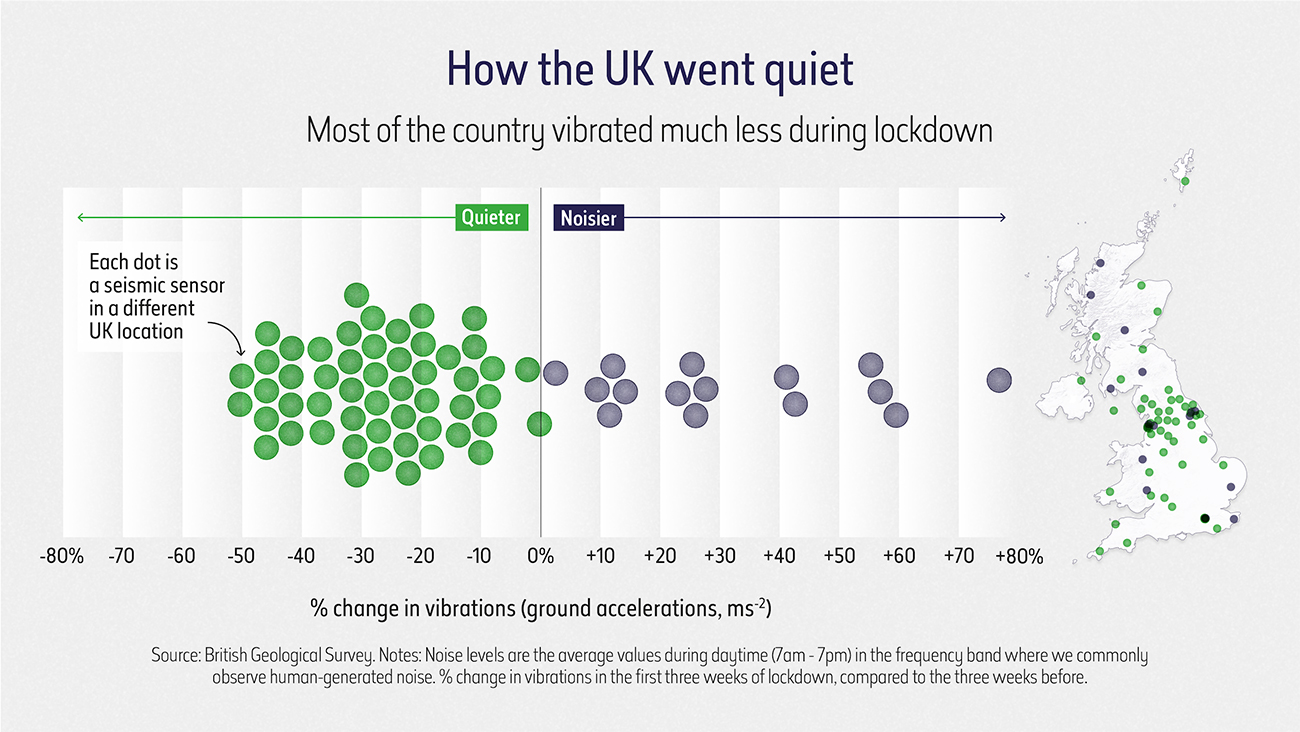

How the UK went quiet, copyright Natural History Museum.
As part of the initiative, NHM collaborated with data visualisation company Beyond Words, who approached BGS to help illustrate some of the environmental changes wrought by lockdown.
The seismic data was brought to their attention when BGS seismologists observed a drop in seismic activity throughout March 2020 in some locations across the UK.
Some areas of the UK were noisier during lockdown, but most of the country vibrated less; a pattern also noted by scientists in locations across Europe when entire countries were brought to a standstill.

We compared the average daytime noise levels at seismic stations in the UK in the two week period since the start of the COVID-19 lockdown with the average noise levels for the beginning of the year. The results show reductions in noise levels at most of our stations of between 10 and 50 per cent.
We see that some of the biggest noise reductions are at sites closest to sources of human-generated noise. Much of our understanding about the Earth comes from observations of earthquakes. So in theory, this could lead to new insights about our planet.
Brian Baptie, BGS Seismologist.
The Nature in Lockdown initiative drew on a variety of open-source data and scientific databases and documented the dramatic drop in driving and public transport use, and the changes to sightings of both animals and birds.
The project, which received funding from the Natural Environment Research Council, culminated in a live interactive virtual ‘Lates’ event on Friday 25 September, during which audiences posed questions to young and emerging researchers about those topics.
These fascinating visualisations, the result of a collaboration between scientists, our digital teams and Beyond Words, bring to life some of the astonishing impacts lockdown has had on our environments and how we noticed and experienced nature in a new and different way.
Clare Matterson, NHM’s executive director of engagement.
You can view the illustrations on The Natural History Museum website.
Find out more about how the BGS collects data to improve our understanding of earthquake hazards.
Relative topics
Related news

Updated national 3D model will determine the depth to the solid bedrock beneath our feet
13/07/2026
The BGS Superficial Deposit Thickness Model now includes an elevation model of geological rockhead for the first time, providing important data for civil engineers, geoscientists and environmental scientists.

UK’s world-class research organisations launch new collective
10/07/2026
The launch of the National Research Organisations Group, brings together more than 100 leaders from government, research, industry and funding organisations, providing an authorativive voice on science, research policy and long-term investment.

Cheshire Geoenergy Observatory releases key geological datasets for UK thermal energy storage scheme design
09/07/2026
A new report and data packs from BGS will provide a unique resource for scientists working on the geology and hydrogeology of the Sherwood Sandstone Formation, an important aquifer and reservoir rock.

New geological mapping underway to help manage flooding along the River Tweed
08/07/2026
Scientists are surveying the Tweed catchment for the first time in over 100 years to enhance understanding of localised groundwater and improve flood forecasting.

Geological research in North Sea helping to safeguard subsea cables
06/07/2026
Subsea power and telecommunications cables are critical to the UK’s energy infrastructure and global connectivity, yet they remain vulnerable to damage from ship anchors, fishing activity and natural hazards.

UK Critical Minerals Intelligence Centre makes recommendations for the next UK criticality assessment
01/07/2026
CMIC has outlined the enhancements made to the next assessment update to ensure it is better tailored to the structure of the UK economy.

From archive to discovery: historical mineral reports support gold exploration in Scotland
25/06/2026
Digitised geological records show potential to unlock untapped mineral resources in Ardlochan, Argyllshire.

UK and Philippines scientists investigate natural hydrogen generation processes at atomic scale
22/06/2026
BGS researchers were granted access to use the Diamond Light Source facility in order to study hydrogen in light brighter than the sun.

Shortage of end-of-life materials presents challenge to UK critical minerals security
17/06/2026
A new report by the UK Critical Minerals Intelligence Centre reveals insufficient end-of-life material stocks present a supply risk over the coming decade, but offer significant long-term potential to meet critical mineral demand through recycling.

UK geothermal catalogue receives update
16/06/2026
BGS releases the second digital version of the UK geothermal catalogue of subsurface temperature and rock thermal conductivity measurements and heat flow calculations.

Scientists make new discovery in the history of the Giant’s Causeway
15/06/2026
New research is changing our scientific understanding of the formation of one of the UK’s most iconic landmarks and has revealed that Northern Ireland’s volcanic past occurred over a much shorter period than previously thought.

Latest research emphasises climate-related subsidence risk to millions of British homes
11/06/2026
New data from BGS highlights the projected future impact of warmer, drier summers and underlines the need for mitigation measures in susceptible regions.