Sea level rise and coastal erosion: what’s the real impact?
How much of an issue are coastal vulnerabilities and what do we need to consider to increase our resilience to future events?
05/04/2022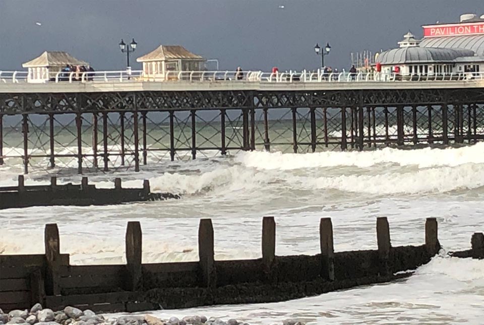
In this new series of blogs, the digital products team looks at the coastline of Great Britain, how it is changing and what important factors we should consider in terms of natural hazards, adaptation and resilience.
Coastal resilience is a key issue for our island nation, especially those who live and work around our coastline. The climate is changing, temperatures are increasing and sea-levels are set to rise. In recent years, we have witnessed numerous examples of coastal flooding, cliff falls and damage to infrastructure, businesses and homes during storms. But how much of an issue are these coastal vulnerabilities and what do we need to consider to increase our resilience to future events?
It is difficult to quantify the threat and potential economic impact of coastal erosion and flooding. The Climate Change Committee’s Adaptation Committee estimated in 2018 that, by the 2080s, over 100 000 properties may be in areas at risk from coastal erosion in England alone.
Various reports have been commissioned over recent years to assist in building a clearer picture of the situation and options to reduce this risk. The UK Government’s latest research on exploratory sea-level projections for the UK provides future projection ranges to the year 2300. Under all scenarios, sea level is expected to continue to rise. Estimates range across (approximately):
- 0.5 m to 2.2 m for low (RCP2.6) emissions
- 0.8 m to 2.6 m for medium-low (RCP4.5) emissions
- 1.4 m to 4.3 m for high (RCP8.5) emissions
To provide some context relating to the societal importance of our coastal regions, aside from their natural significance, we can consider some of the findings of a 2019 report by a Select Committee appointed through the House of Lords. This group and the subsequent report had been set up to focus on the regeneration of seaside towns and communities, which included a review of tourism and hospitality. Based on this report and the associated proceedings, the following numbers can be ascribed to our coastal regions:
- more than eight million people live on the coast, in coastal communities (Select Committee on Regenerating Seaside Towns and Communities (2018))
- according to UKHospitality, the sector employs 2.9 million people and generates £130 billion in economic activity
- VisitBritain stated that tourism was worth £127 billion to the British economy (Select Committee meeting).
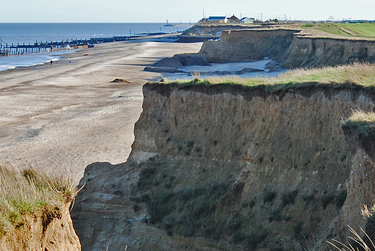
In the UK, current annual damages from coastal flooding are estimated at over £500 million per year (British Antarctic Survey) and costs are likely to increase under projections of future sea-level rise. Historic assets are also under threat: buried archaeology and historic structures, such as the Godwin Battery on Spurn Point, have already been lost to coastal erosion. The National Trust’s repair bill following the 2013/14 winter storms amounted to some £250 000, with other repairs costing many thousands of pounds.
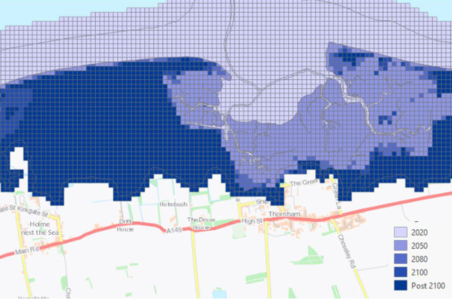
Our new GeoCoast data product can be used to inform and assist users when responding to coastal adaptation and resilience. GeoCoast is an integrated GIS package of datasets designed to inform and support coastal management and adaptation. It includes information about coastal erosion, sea-level rise and inundation, coastal subsidence and the properties of the geological deposits.
Our next post in this series will look at six areas of changing coastlines around Great Britain and how climate change could affect them.
Join us for our GeoCoast launch event
Join our data products team for a live webinar on the 28 April 2022, and discover more about our new data product to underpin coastal decision making, resilience and adaptation. > Register online
About the author

Kathryn Lee
Geologist and BGS Informatics product portfolio manager
Relative topics
You may also be interested in:
GeoCoast Premium
GeoCoast is an integrated GIS package of datasets designed to inform and support coastal management and adaptation.
Coasts and estuaries geohazards
Providing independent and expert geoscientific tools and advice to assess different adaptation options to coastal flooding and erosion.

New BGS datasets for coastal management, planning and adaptation in the face of climate change
BGS GeoCoast is a package of geospatial datasets designed to provide information on the geological conditions and constraints around the coastline of Britain.
Related news

Updated geological assessment of the Southern North Sea set to underpin future offshore infrastructure development
25/03/2026
The first regional assessment for 30 years will support offshore marine and subsurface planning for the UK’s low-carbon energy infrastructure, including the 2030 target of 45 to 50 GW generated through offshore wind.

New research could help provide a more reliable water supply for millions in rural Africa
24/03/2026
A new BGS-led study has revealed crucial insights into the longstanding challenges affecting the reliability and performance of rural water supply infrastructure in sub-Saharan Africa.

Call for new members and Chair to join the NERC facilities steering committees
25/02/2026
New members are needed to join the committees over the next four years.

Your views wanted: developing a geothermal energy subsurface data portfolio
24/02/2026
BGS is aiming to support the growth of the sector by providing the best-available, location-specific geothermal and ground source heat information as an accessible product or service.

Map of BGS BritPits showing the distribution of worked mineral commodities across the country
18/02/2026
BGS’s data scientists have generated a summary map of the most commonly extracted mineral commodities by local authority area, demonstrating the diverse nature of British mineral resources.

Funding awarded to map the stocks and flows of technology metals in everyday electronic devices
12/02/2026
A new BGS project has been awarded Circular Electricals funding from Material Focus to investigate the use of technology metals in everyday electrical items.

New UK/Chile partnership prioritises sustainable practices around critical raw materials
09/02/2026
BGS and Chile’s Servicio Nacional de Geología y Minería have signed a bilateral scientific partnership to support research into critical raw materials and sustainable practices.

Extensive freshened water confirmed beneath the ocean floor off the coast of New England for the first time
09/02/2026
BGS is part of the international team that has discovered the first detailed evidence of long-suspected, hidden, freshwater aquifers.

Funding secured to help mitigate ground risk in UK construction sector
05/02/2026
The BGS Common Ground project has been awarded new funding to help unlock the value of ground investigation data.

Can sandstones under the North Sea unlock the UK’s carbon storage potential?
02/02/2026
For the UK to reach its ambitious target of storing 170 million tonnes of carbon dioxide per year by 2050, it will need to look beyond the current well-studied geographical areas.

Quaternary UK offshore data digitised for the first time
21/01/2026
The offshore wind industry will be boosted by the digitisation of a dataset showing the Quaternary geology at the seabed and the UK’s shallow subsurface.

Suite of ten new soil reference materials released
02/01/2026
BGS has a longstanding track record of producing high-quality reference materials and has released ten new soil reference materials.