Nearly three million people in Indonesia’s second city could be affected by an earthquake
BGS-led research reveals the number of people in the Bandung metropolitan region who could be exposed to a major earthquake.
17/07/2024 By BGS Press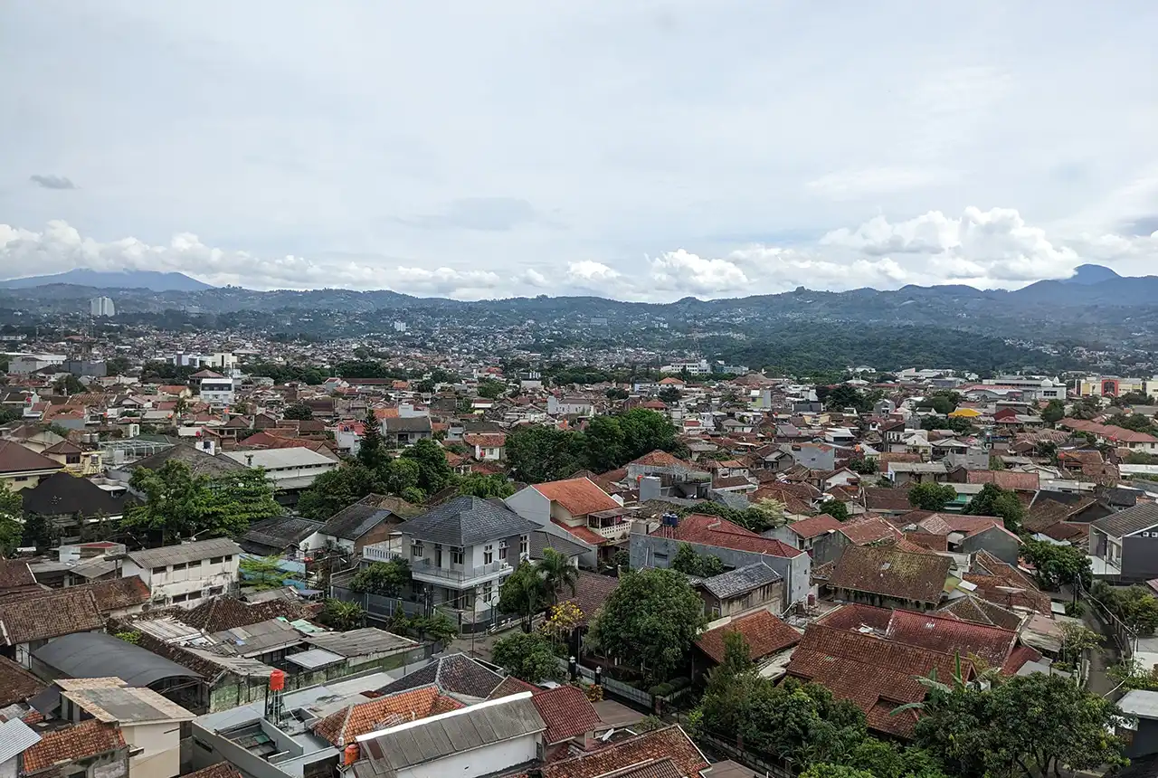

Research led by a BGS scientist has revealed that an estimated 1.9 to 2.7 million people in the Bandung metropolitan region of Indonesia would be exposed to high levels of ground shaking from an earthquake on the nearby Lembang Fault.
Over the past five years, Ekbal Hussain, a remote sensing geoscientist at BGS, has worked alongside scientists in Indonesia to research and produce deformation maps for the Bandung metropolitan region. To do this, they used a combination of data from satellites and GPS measurements made around the fault.
Bandung is the capital of West Java, Indonesia, and has a population of approximately 8.4 million people. The centre of the city lies less than 10 km south of the Lembang Fault, a major fracture between two blocks of rock in West Java. Although there are no documented records of large historical earthquakes, the Lembang Fault shows geomorphological evidence of significant earthquakes in the 15th century.
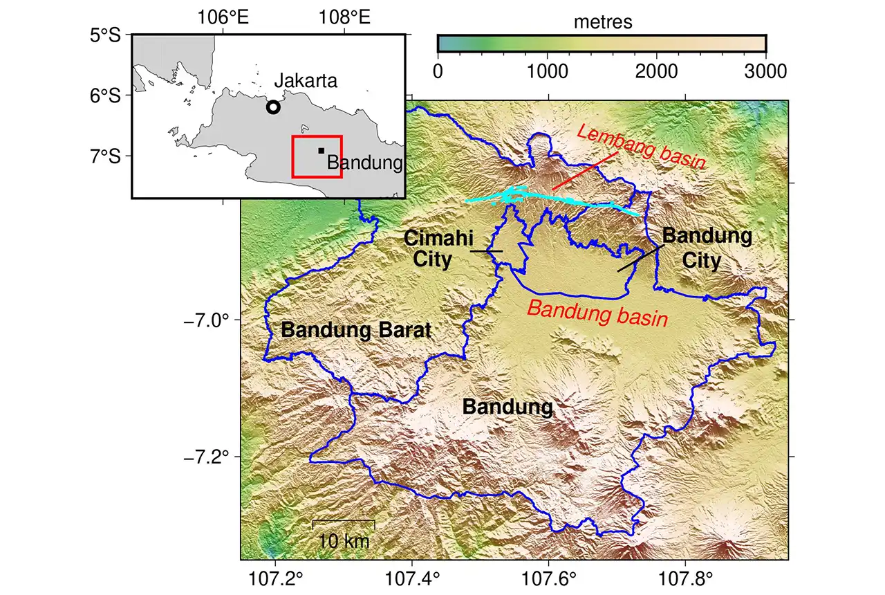
The Bandung metropolitan region and the Lembang Fault. BGS © UKRI.
A fault’s slip rate is the average amount of earthquake energy accumulation each year; using different techniques, this had previously been estimated to either be between 1.95 to 3.45 mm a year or 6 mm a year for the Lembang Fault. This new study has found that the slip rate is 4.7 mm a year.
Using this new slip rate alongside previous studies, which estimated the recurrence period of large earthquakes on the fault at between 170 and 670 years, it can be estimated that the magnitude of an earthquake will be between 6.6 and 7.0. If such earthquakes were to occur on the fault today they would expose approximately 1.9 million to 2.7 million people within the Bandung metropolitan region to high levels of ground shaking, greater than 0.3 g, or 30 per cent of the strength of gravity.
The research highlights the importance of not forgetting local crustal faults located near large urban centres, which also pose a high risk to communities.

In Indonesia, the perceived risk of earthquakes is from large events on the subduction zone. However, in this paper, we show that shorter faults like the Lembang Fault, located much closer to major cities, can also be extremely dangerous.
Ekbal Hussain, BGS Remote Sensing Geoscientist.
Funding
This is work is funded by the UK National Capability ‘Geoscience to tackle global environmental challenges’ programme. The BGS and Indonesian researchers involved in this study are continuing their engagement with local government to address the hazard challenges raised in this work.
More information
Access the full paper: The seismic hazard from the Lembang Fault, Indonesia, derived from InSAR and GNSS data
Relative topics
Related news

Building Europe’s geological future
20/07/2026
BGS scientists are contributing to a continent-wide initiative that is strengthening collaboration across borders to tackle shared subsurface challenges and unlock new opportunities.

Delving deep into mountains for future water security
16/07/2026
A BGS-led project is using new water-tracing investigation methods, geophysics and modelling to understand how water moves from mountains to the lowlands, helping to improve water security for billions of people.

Ukraine and the UK strengthen their commitment to geological cooperation
10/06/2026
A new Memorandum of Understanding reaffirms the UK’s support of Ukraine’s ambitions to develop its critical mineral resources, paving the way for collaboration through capacity-building programmes.

International science consortium to survey the health, economic value and social importance of Lake Victoria
22/05/2026
The project will replicate the 1927 survey to assess changes in the lake’s health, economic value and social importance.

BGS contributes to UN sand and sustainability report
19/05/2026
The new report highlights the impact of poor governance and unsustainable sand mining practices, calling on policymakers to take action.
BGS engineering geologist elected to CCOP
29/04/2026
Marcus Dobbs has been elected as vice-chair of the advisory group for the Coordinating Committee for Geoscience Programmes in East and Southeast Asia.

Strengthening capacity through partnership: a critical minerals perspective
28/04/2026
BGS has been working in partnership with the Geological Survey Department of Zambia (GSD) to build national capacity, improve data accessibility and support long-term, sustainable development.

New research could help provide a more reliable water supply for millions in rural Africa
24/03/2026
A new BGS-led study has revealed crucial insights into the longstanding challenges affecting the reliability and performance of rural water supply infrastructure in sub-Saharan Africa.

New UK/Chile partnership prioritises sustainable practices around critical raw materials
09/02/2026
BGS and Chile’s Servicio Nacional de Geología y Minería have signed a bilateral scientific partnership to support research into critical raw materials and sustainable practices.

Extensive freshened water confirmed beneath the ocean floor off the coast of New England for the first time
09/02/2026
BGS is part of the international team that has discovered the first detailed evidence of long-suspected, hidden, freshwater aquifers.
Perth and Kinross tops the UK’s earthquake activity charts for 2025
29/12/2025
Seismologists at BGS have published data on the number of seismic events over the past 12 months with over 300 earthquakes recorded.

Hole-y c*@p! How bat excrement is sculpting Borneo’s hidden caves
23/12/2025
BGS researchers have delved into Borneo’s underworld to learn more about how guano deposited by bats and cave-dwelling birds is shaping the subsurface.