BGS launches new Geology Viewer
A new app providing easy access to the subsurface of Britain has been released by BGS.
30/06/2022 By BGS Press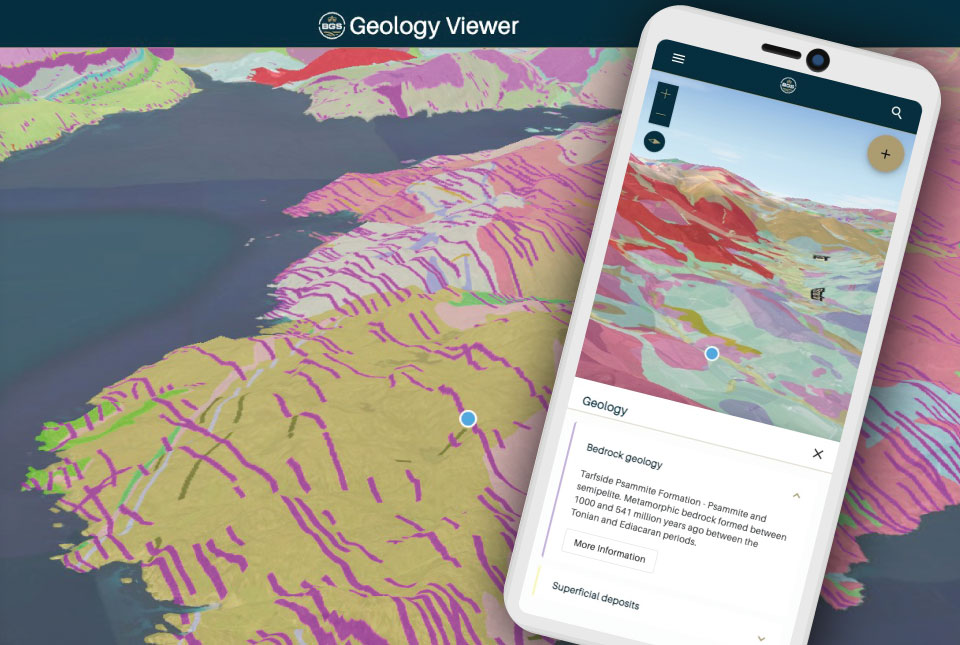

The BGS Geology Viewer has been designed to provide geology enthusiasts and the general public with bedrock and superficial geology maps of Great Britain. Anyone with a browser-enabled device — including mobiles, tablets and laptops — can use the free application.
The GPS-enabled viewer allows users to zoom to their location and tap the 3D map for information on each geology layer and how it was formed. The dynamic map legend updates to display only the visible rock formations and users can access further information with links to additional records in the BGS Lexicon. The viewer is also customisable, with a range of different base maps to choose from.
The application has been designed as a streamlined successor to some of BGS’s existing viewers. The mobile-first design is intended to make the new viewer available to a much wider range of users across different devices.
It will not be found in the Apple or Google App stores; instead, users can access the viewer through the BGS website.
Mobile users can also choose to add the app to their home screen and launch it like a native app. Initially launched in beta, further development is planned over the coming years to provide exciting new functionality to meet the evolving needs of our data users.
Following the launch, two older BGS applications, iGeology and the Geology of Britain Viewer, will be retired on 1 August.
For professional users who need to access BGS data as part of their business requirements, BGS GeoIndex is also available, containing borehole records and a comprehensive BGS data catalogue.
For further information, including frequently asked questions, troubleshooting and where to send feedback, please visit the BGS Geology Viewer application page.
Relative topics
Related news

Delving deep into mountains for future water security
16/07/2026
A BGS-led project is using new water-tracing investigation methods, geophysics and modelling to understand how water moves from mountains to the lowlands, helping to improve water security for billions of people.

Updated national 3D model will determine the depth to the solid bedrock beneath our feet
13/07/2026
The BGS Superficial Deposit Thickness Model now includes an elevation model of geological rockhead for the first time, providing important data for civil engineers, geoscientists and environmental scientists.

UK’s world-class research organisations launch new collective
10/07/2026
The launch of the National Research Organisations Group brings together more than 100 science leaders to provide an authorativive voice on science, research policy and long-term investment.

Cheshire Geoenergy Observatory releases key geological datasets for UK thermal energy storage scheme design
09/07/2026
A new report and data packs from BGS will provide a unique resource for scientists working on the geology and hydrogeology of the Sherwood Sandstone Formation, an important aquifer and reservoir rock.

New geological mapping underway to help manage flooding along the River Tweed
08/07/2026
Scientists are surveying the Tweed catchment for the first time in over 100 years to enhance understanding of localised groundwater and improve flood forecasting.

Geological research in North Sea helping to safeguard subsea cables
06/07/2026
Subsea power and telecommunications cables are critical to the UK’s energy infrastructure and global connectivity, yet they remain vulnerable to damage from ship anchors, fishing activity and natural hazards.

UK Critical Minerals Intelligence Centre makes recommendations for the next UK criticality assessment
01/07/2026
CMIC has outlined the enhancements made to the next assessment update to ensure it is better tailored to the structure of the UK economy.

From archive to discovery: historical mineral reports support gold exploration in Scotland
25/06/2026
Digitised geological records show potential to unlock untapped mineral resources in Ardlochan, Argyllshire.

UK and Philippines scientists investigate natural hydrogen generation processes at atomic scale
22/06/2026
BGS researchers were granted access to use the Diamond Light Source facility in order to study hydrogen in light brighter than the sun.

Shortage of end-of-life materials presents challenge to UK critical minerals security
17/06/2026
A new report by the UK Critical Minerals Intelligence Centre reveals insufficient end-of-life material stocks present a supply risk over the coming decade, but offer significant long-term potential to meet critical mineral demand through recycling.

UK geothermal catalogue receives update
16/06/2026
BGS releases the second digital version of the UK geothermal catalogue of subsurface temperature and rock thermal conductivity measurements and heat flow calculations.

Scientists make new discovery in the history of the Giant’s Causeway
15/06/2026
New research is changing our scientific understanding of the formation of one of the UK’s most iconic landmarks and has revealed that Northern Ireland’s volcanic past occurred over a much shorter period than previously thought.