Below the bonnie banks: mapping Loch Lomond’s underwater landslides
Using high-resolution, multibeam bathymetry and shallow seismic imaging, BGS’s marine geoscience and landslides teams are mapping historic landslides under the waters of Loch Lomond.
07/03/2023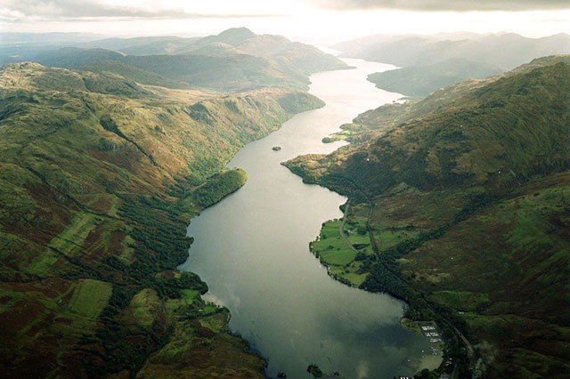

Loch Lomond is an iconic part of Scotland’s scenery, surrounded by a variety of landforms that tell us about the region’s glacial past. But hidden beneath the water is a less well-known landscape that also has an important story to tell. Researchers from BGS’s marine geoscience and landslides teams have been studying evidence for landslides that have occurred under the water since the retreat of the last glaciers in the area, around 11 700 years ago.
Landslides around and in Loch Lomond
Onshore, evidence for landslides is quite common in steep highland areas like that around Loch Lomond. Most activity occurred soon after the last glaciers melted, when the landscape was adjusting to the removal of the thick ice cover after the end of the last ice age. Today, landslides are less frequent. They mainly go unnoticed in remote hills but can still be extremely disruptive when they coincide with infrastructure.
Like their onshore counterparts, most of the underwater landslide activity appears to have occurred in the centuries immediately following glacier retreat and the underwater landscape is far more stable now. What we didn’t know is how this activity has affected the beds of lochs such as Loch Lomond. Using high-resolution, multibeam bathymetry and shallow seismic images collected by BGS, the team have detected evidence for widespread, underwater landslide activity in the loch itself. The locations of these past landslides can give clues to where underwater slopes may still be susceptible.
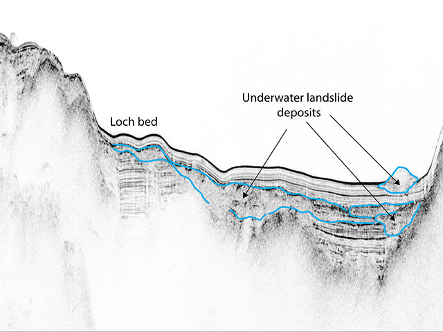
Seismic image showing deposits below the bed of Loch Lomond. Old, buried landslide deposits can be identified as well as a smaller, more recent one on the loch bed surface. BGS © UKRI.
Recent activity
The team has found some evidence for more recent underwater landslide activity, too. They were particularly interested in a site known as Wade’s Bridge Bank. A report from the 1980s (Trunk Road A82: the Loch Lomondside road: conception to implementation) describes a displacement of rockfill during the construction of an embankment for the A82. The embankment was completed and settled as planned before work began on the road, but little was reported on the impact that the earlier rockfill displacement had on the loch bed, primarily because high-resolution bathymetric survey technology didn’t exist at the time.
BGS’s research
This is where the new multibeam and shallow seismic data come in. The teams’ findings, published in the Quarterly Journal of Engineering Geology and Hydrogeology, show that the event likely initiated a series of underwater landslides travelling some 700 m and reaching almost halfway across the loch. Using information from the original report alongside interpretations from the new data, the teams were also able to run computer models to simulate the underwater landslide runout following the embankment displacement.
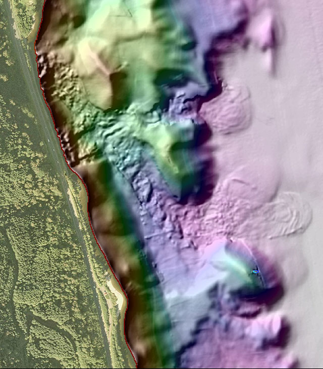
The track of a more recent underwater landslide can be seen using multibeam imagery of the loch bed. BGS © UKRI.
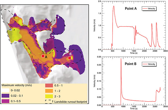
Computer models are used to simulate the runout of the landslide. BGS © UKRI.
Work is continuing to build a database of past landslides in Loch Lomond, which we hope to extend to include other lochs and steep, near-shore sites in Britain. The techniques used in Loch Lomond also open excellent opportunities to investigate underwater slope processes at near-shore sites in steep glaciated settings. This is valuable not only in locations where infrastructure is planned along steep shorelines, but also where cables and pipelines associated with offshore energy could be severely damaged by such slope movements.
Further reading
- Carter, G D, Cooper, R, Gafeira, J, Howe, J A, and Long, D. 2020. Morphology of small-scale submarine mass movement events across the northwest United Kingdom. Geomorphology, Vol. 365, 107282. DOI: https://doi.org/10.1016/j.geomorph.2020.107282
- Finlayson, A, Nedumpallile-Vasu, N, Carter, G, Dakin, N, and Cooper, R. In press. Subaqueous landslides associated with historic road improvements in steep glaciated terrain, Loch Lomond, Western Scotland. Quarterly Journal of Engineering Geology and Hydrogeology. DOI: https://doi.org/10.1144/qjegh2022-075
- Howison, J A, and MacDonald, A. 1988. Trunk Road A82: Loch Lomondside Road: Conception To Implementation. Proceedings of the Institution of Civil Engineers, Vol. 84(3), 497–518. DOI: https://doi.org/10.1680/iicep.1988.32
About the author

Dr Andrew Finlayson
Head of BGS Marine Geoscience