The experience of the team in electrical resistivity tomography and other geophysical techniques is applied to a varied range of applications. Electrical resistivity tomography (ERT) monitoring as a technique is cutting edge, and the leaders in this field within the team mean that BGS Geophysical Tomography (GTom) is ideally placed to study a large number of dynamic situations.
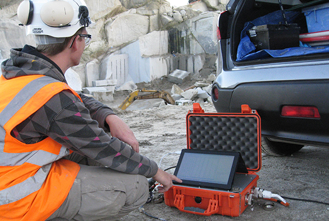

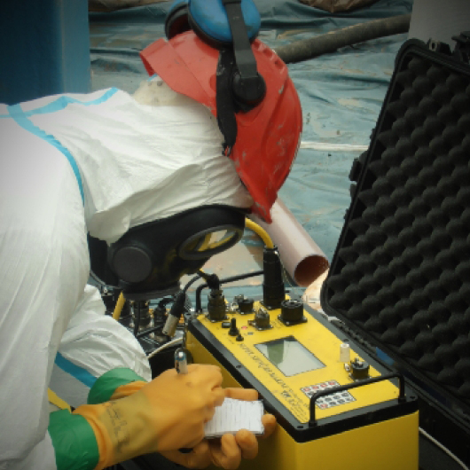
Data collection in a quarry.
Applications range from mineral exploration and waste management to monitoring active processes within the subsurface, such as the movement of pollutants or the flow of groundwater in unstable slopes affecting infrastructure.
Quick links
- Infrastructure and asset management
- Energy
- Hydrogeophysics
- Mineral exploration and mining
- Radioactive containment
- Non-destructive evaluation
- Contaminated land and mine waste
- Geohazards
- Waste management
Infrastructure and asset management
Geotechnical and related assets (e.g. cuttings, embankments, foundations, and dams) underpin tens of thousands of kilometres of UK transportation and utilities infrastructure. Many of these assets were constructed over 100 years ago and are typically very poorly engineered compared to modern standards. These assets are experiencing increasingly high levels of failure and require considerable resources to maintain — hundreds of millions of pounds per year in the UK alone — a situation that is being exacerbated by the greater frequency of extreme rainfall events (e.g. winter 2013–2014, February 2020).
Early identification of deteriorating condition generally allows low-cost preventative remediation to be undertaken and reduces the risk of catastrophic failures. However, conventional approaches (e.g. walkover surveys or intrusive sampling) to condition monitoring are often inadequate for predicting failure events.
GTom is developing novel geophysical approaches to characterise and monitor geotechnical assets with the aim of improving asset management. The key benefits of geophysical methods such as ERT are that they can provide non-invasive spatial subsurface information; they can be very sensitive to moisture-driven deterioration processes, and they can be configured to enable remote condition monitoring of assets.
The team has developed novel geophysical monitoring technology to enable cost-effective remote condition monitoring of assets. This technology is called Proactive Infrastructure Monitoring and Evaluation (PRIME) and was developed through NERC’s Environmental Risks to Infrastructure Innovation Programme. More information can be found on our dedicated PRIME page, or our research highlight page BGS PRIME: An early warning system for slope failure.
The BGS is contributing geophysical expertise to the EPSRC-funded ACHILLES project, which is led by Prof Stephanie Glendinning at Newcastle University. The project is investigating how we can improve the resilience of long, linear infrastructure assets (e.g. railways; flood embankments) to environmental pressures.
Jessica Holmes is a joint PhD student with Queens University Belfast (supervisor: Dr Shane Donohue) and the BGS. Her research project is concerned with developing geophysical methodologies for slope stability assessment in the context of rail infrastructure. She has test sites in British Columbia (Canada) and Nottingham (UK).
John Ball is a joint PhD student with Lancaster University (supervisor: Prof Andy Binley) and the BGS. He is researching the use of geoelectrical monitoring for assessing the integrity of water-retaining structures, such as dams and flood embankments.
Chambers, J E, Gunn, D A, Wilkinson, P B, Meldrum, P I, Haslam, E, Holyoake, S, Kirkham, M, Kuras, O, Merritt, A, and Wragg, J. 2014. 4D electrical resistivity tomography monitoring of soil moisture dynamics in an operational railway embankment. Near Surface Geophysics, Vol. 12(1), 61–72.
Glendinning, S, Hughes, P, Helm, P, Chambers, J, Mendes, J, Gunn, D, Wilkinson, P, and Uhlemann, S. 2014. Construction, management and maintenance of embankments used for road and rail infrastructure: implications of weather induced pore water pressures. Acta Geotechnica, Vol. 9, 799–816.
Gunn, D A, Chambers, J E, Uhlemann, S, Wilkinson, P B, Meldrum, P I, Dijkstra, T A, Haslam, E, Kirkham, M, Wragg, J, Holyoake, S, Hughes, P N, Hen-Jones, R, and Glendinning, S. 2015. Moisture monitoring in clay embankments using electrical resistivity tomography. Construction and Building Materials, Vol. 92, 82–94.
Gunn, D A, Chambers, J E, Dashwood, B E, Lacinska, A, Dijkstra, T, Uhlemann, S, Swift, R, Kirkham, M, Milodowski, A ,Wragg, J, and Donohue, S. 2018. Deterioration model and condition monitoring of aged railway embankment using non-invasive geophysics. Construction and Building Materials, Vol. 170, 668–678.
Hen-Jones, R M, Hughes, P N, Stirling, R A, Glendinning, S, Chambers, J E, Gunn, D A, and Cui, Y J. 2017. Seasonal effects on geophysical-geotechnical relationships and their implications for electrical resistivity tomography monitoring of slopes. Acta Geotechnica, Vol. 12, 1159–1173.
Smethurst, J A, Smith, A, Uhlemann, S, Wooff, C, Chambers, J, Hughes, P, Lenart, S, Saraglou, H, Springman, S M, Löfroth, H, and Hughes, D. 2017. Current and future role of instrumentation and monitoring in the performance of transport infrastructure slopes. Quarterly Journal of Engineering Geology and Hydrogeology, Vol. 50(3), 271–286.
If you want to discover more then please contact Jonathan Chambers.
Energy
We apply geoelectrical monitoring and associated techniques in boreholes and at the surface to address geoscience challenges related to energy (e.g. conventional and unconventional hydrocarbons; carbon capture, utilisation and storage; geothermal). Key research questions focus around subsurface fluid flow and monitoring of the near-surface environment (e.g. aquifers).
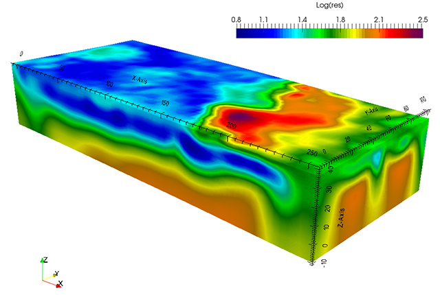
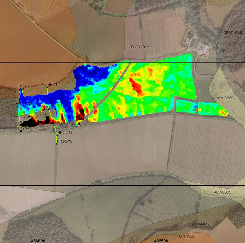
3D resistivity model of the geoenergy test bed site at Sutton Bonington, Nottinghamshire.
GTom is playing a key role in the UK Geoenergy Observatories in Glasgow and Cheshire, studying geothermal heating capacity and subsurface fluid flow at the sites.
Cross-borehole ERT arrays have been installed by the team at the GeoEnergy Test Bed, with the aim of monitoring fluid and gas flow in the near surface.
If you want to discover more then please contact Oliver Kuras or Jonathan Chambers.
Hydrogeophysics
ERT is ideally suited to hydrogeological assessment and monitoring. Its sensitivity to fluids mean that it is able to image groundwater at a high spatial and temporal resolution.
Our work within the CEPHaS project involves using ERT monitoring to image changing hydrodynamics through the growing season under differing agricultural techniques in southern Africa. The aim is to better understand the how conservation agriculture may provide drought and climate change resilience, enabling policymakers and stakeholders to make increasingly informed decisions.
In the IMAGER project, time-lapse ERT has been used to monitor groundwater changes caused by pump-driven dewatering in a sand aquifer in a quarry environment.
Chambers, J, Meldrum, P I, Wilkinson, P B, Ward, W, Jackson, C, Matthews, B, Joel, P, Kuras, O, Bai, L, Uhlemann, S, and Gunn, D. 2015. Spatial monitoring of groundwater drawdown and rebound associated with quarry dewatering using automated time-lapse electrical resistivity tomography and distribution guided clustering. Engineering Geology, Vol. 193, 412–420.
Uhlemann, S, Chambers, J, Wilkinson, P, Maurer, H, Merritt, A, Meldrum, P, Kuras, O, Gunn, D, Smith, A, and Dijkstra, T. 2017. Four-dimensional imaging of moisture dynamics during landslide reactivation. Journal of Geophysical Reasearch: Earth Science, Vol. 122(1), 398–418.
Uhlemann, S, Kuras, O, Richards, L A, Naden, E, and Polya, D A. 2017. Electrical resistivity tomography determines the spatial distribution of clay layer thickness and aquifer vulnerability, Kandal Province, Cambodia. Journal of Asian Earth Sciences, Vol. 147, 402–414.
If you want to discover more then please contact Jonathan Chambers.
Mineral exploration and mining
Although geophysical methods such as ERT have long been used to support mineral exploration, the full benefits of emerging geophysical imaging technologies have yet to be fully realised in the industry.
The principal advantages of ERT for this application are that it is a cost-effective, non-invasive method that can provide 2D or 3D spatial models of the subsurface throughout the full region of interest. This complements intrusive sampling methods, which typically provide information only at discrete locations.
Provided that suitable resistivity contrasts are present, ERT has the potential to reveal mineral and overburden thickness and quality variations as well as discontinuities within the body of the deposit. In addition, ERT can be used to monitor the effect of groundwater abstraction and dewatering due to its sensitivity to changing moisture levels. Consequently, we are developing electrical imaging methods for a range of mining-related characterisation and monitoring applications.
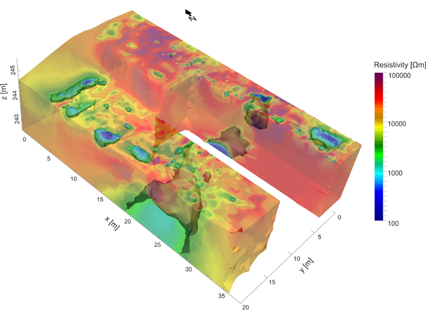
3D ERT model showing major cavities and discontinuities within a marble deposit in northern Italy.
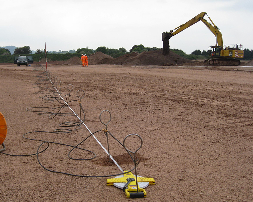
ERT data collection in an aggregate quarry.
The IMAGER project, funded by Defra, was concerned with developing resistivity imaging for soft-rock exploration, reserve estimation and water management in the context of quarrying.
SUSTAMINING was an EU-funded project established to develop non-invasive geophysical approaches for enhanced dimension stone (hard rock) resource investigation and exploitation.
Chambers, J E, Wilkinson, P B, Wardrop, D, Hameed, A, Hill, I, Jeffrey, C, Loke, M H, Meldrum, P I, Kuras, O, Cave, M, and Gunn, D A. 2012. Bedrock detection beneath river terrace deposits using three-dimensional electrical resistivity tomography. Geomorphology, Vols. 177–178, 17–25.
Chambers, J E, Wikinson, P B, Penn, S, Meldrum, P I, Kuras, O, Loke, M H, and Gunn, D A. 2013. River terrace sand and gravel deposit reserve estimation using three-dimensional electrical resistivity tomography for bedrock surface detection. Journal of Applied Geophysics, Vol. 93, 25–32.
Chambers, J, Meldrum, P I, Wilkinson, P B, Ward, W, Jackson, C, Matthews, B, Joel, P, Kuras, O, Bai, L, Uhlemann, S, and Gunn, D. 2015. Spatial monitoring of groundwater drawdown and rebound associated with quarry dewatering using automated time-lapse electrical resistivity tomography and distribution guided clustering. Engineering Geology, Vol. 193, 412–420.
Uhlemann, S, Chambers, J, Eberhard Falck, W, Tirado Alonso, A, Fernández González, J L, and Espín de Gea, A. 2018. Applying electrical resistivity tomography in ornamental stone mining: challenges and solutions. Minerals, Vol. 8(11), 491.
If you want to discover more then please contact Jonathan Chambers.
Radioactive containment
We have developed leak detection and monitoring capability to ensure radioactive containment based on cross-borehole geoelectrical monitoring and associated techniques. Research is undertaken to support hazard reduction in nuclear decommissioning (e.g. at Sellafield) as well as to prepare for potential future geological disposal of radioactive waste.
ERT data collection at Sellafield, UK.
Kuras, O, Wilkinson, P B, Meldrum, P I, Oxby, L S, Uhlemann, S, Chambers, J E, Binley, A, Graham, J, Smith, N T, and Atherton, N. 2016. Geoelectrical monitoring of simulated subsurface leakage to support high-hazard nuclear decommissioning at the Sellafield Site, UK. Science of the Total Environment, Vols. 566–567, 350–359.
If would like to discover more then please contact Oliver Kuras or Jonathan Chambers.
Non-destructive evaluation
We exploit the unique benefits of near-surface geophysical techniques to develop novel approaches to non-destructive testing (NDT) and evaluation (NDE) of advanced materials and engineered structures. Technology transfer from earth science to other domains (e.g. defence; security; material testing; engineering) is the wider aim of these efforts.
Calibration of CRI equipment for evaluating composites.
If you would like to discover more then please contact Oliver Kuras or Jonathan Chambers.
Contaminated land and mine waste
Geoelectrical methods are well suited to the characterisation and monitoring of subsurface contaminant transport. We are working on a range of projects developing resistivity and induced polarisation methods for pollution and waste applications.
The CLARET project involved 4D cross-borehole monitoring of a contaminated land site that had recently been remediated. The trace-test results showed good resolution of a simulated contaminate plume, while the project results showed that the land had been successfully remediated.
If you would like to discover more then please contact Jonathan Chambers.
Geohazards
In the context of ground instability, the observation of surface morphology tells us about failure events that have already happened or are happening. Consequently, many of the conventional investigative techniques (e.g. remote sensing; LiDAR; inclinometers) that rely upon such observations will not necessarily provide us with a prior warning of when the next failure event is going to occur. The reason for this is that such methods only monitor the physical expression rather than the causal process.
As a team, we are interested in developing geoelectrical methods to investigate a range of processes relating to ground instability, including classical landslides and slope instability, sinkhole development, and even frozen ground (freeze–thaw)-related hazards. A common link between many of these processes is the role of moisture-driven change in the subsurface. Our research is concerned with developing geophysical approaches to detect and characterise these processes, thereby providing early warning of surface expressions of failure.
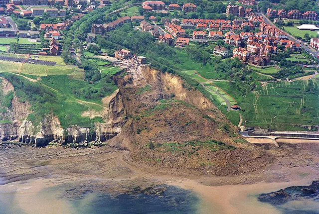
Electro-magnetic survey of a landslide in Yorkshire, UK. Contains Ordnance Data © Crown Copyright and database rights 2020 . Ordnance Survey Licence no. 100021290.
The team has developed novel geophysical monitoring technology that is able to remotely monitor geohazards. This technology is called Proactive Infrastructure Monitoring and Evaluation (PRIME) and was developed through NERC’s Environmental Risks to Infrastructure Innovation Programme. More information can be found on our dedicated PRIME page, or our research highlight page BGS PRIME: An early warning system for slope failure.
Together with BGS Landslides, GTom have been monitoring the landslide at Hollin Hill, Yorkshire since 2008, with its ALERT system forming one of the elements of the long term BGS landslide observatory at the site.
The GTom team are working in partnership with Amrita Center for Wireless Networks and Applications (AWNA), using PRIME technology to monitor a landslide in Munnar (Kerala, India) as part of the Official Development Assistance (ODA) programme.
A PRIME system is installed at the Aldbrough coastal landslide observatory. GTom work closely with BGS Landslides, providing ERT data to complement the suite of measurements collected at this site.
Chambers, J E, Wilkinson, P B, Kuras, O, Ford, J R, Gunn, D A, Meldrum, P I, Pennington, C V L, Weller, A L, Hobbs, P R N, and Olgivy, R D. 2011. Three-dimensional geophysical anatomy of an active landslide in Lias Group mudrocks, Cleveland Basin, UK. Geomorphology, Vol. 125(4), 472–;484.
Gunn, D A, Chambers, J E, Hobbs, P R N, Wilkinson, P B, Jenkins, G O, and Merritt, A. 2013. Rapid observations to guide the design of systems for long-term monitoring of a complex landslide in the Upper Lias clays of North Yorkshire, UK. Quarterly Journal of Engineering Geology and Hydrogeology, Vol. 46(3), 323–336.
Merritt, A J, Chambers, J E, Murphy, W, Wilkinson, P B, West, L J, Gunn, D A, Meldrum, P I, Kirkham, M, and Dixon, N. 2013. 3D ground model development for an active landslide in Lias mudrocks using geophysical, remote sensing and geotechnical methods. Landslides, Vol. 11, 537–550.
Uhlemann, S, Smith, A, Chambers, J, Dixon, N, Dijkstra, T, Haslam, E, Meldrum, P, Merritt, A, Gun,, D, and Mackay, J. 2016. Assessment of ground-based monitoring techniques applied to landslide investigations. Geomorphology, Vol. 253, 438–451.
Uhlemann, S, Chambers, J, Wilkinson, P, Maurer, H, Merritt, A, Meldrum, P, Kuras, O, Gunn, D, Smith, A, and Dijkstra, T. 2017. Four-dimensional imaging of moisture dynamics during landslide reactivation. Journal of Geophysical Reasearch: Earth Science, Vol. 122(1), 398–418.
Whiteley, J S, Chambers, J E, Uhlemann, S, Boyd, J, Cimpoiasu, M O, Holmes, J L, Inauen, C M, Watlet, A, Hawley-Sibbett, L R, Sujitapan, C, Swift, R T, and Kendall, J M. 2020. Landslide monitoring using seismic refraction tomography — the importance of incorporating topographic variations. Engineering Geology, Vol. 268, 105525.
If you would like to discover more then please contact Jonathan Chambers.
Waste management
Geoelectrical methods are highly applicable to waste management problems. They provide solutions both for landfill monitoring and characterisation. Due to its non-invasive manner, valuable information can be gained, minimising the amount of required boreholes, which are a potential risk to penetrate natural barriers, opening up new pathways, or changing the hydraulic model.
We are involved in using resistivity and induced polarisation (IP) imaging in combination with other geophysical methods to characterise landfills in the Interreg RAWFILL project. A detailed knowledge about existing landfills is essential to evaluate the potential for landfill mining and to plan remediation activities.
We have developed a novel automated time-lapse electrical resistivity tomography (ALERT) monitoring concept to facilitate an improved operational control of gas/leachate generation with the Waste Management ALERT project.
If you would like to discover more then please contact Cornelia Inauen or Jonathan Chambers.
Our current research

Landslides
Building resilience both in the UK and internationally to landslides and carrying out many aspects of landslide research.
BGS PRIME: an early warning system for slope failure
Dam and slope failures can lead to the wide-scale destruction of property and, in some cases, catastrophic loss of life.
Engineering and Geotechnical Capability
Leading the development and application of field and laboratory infrastructure and long-term management of geophysical and geotechnical property data.